Bridge Statistics for Redfield, Texas (TX)
Condition, Traffic, Stress, Structural Evaluation, Project Costs
- National Bridge Inventory (NBI) Statistics
- 11Number of bridges
- 118ft / 35.5mTotal length
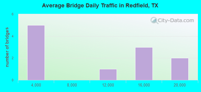
- 89,825Total average daily traffic
- 20,394Total average daily truck traffic
- National Bridge Inventory (NBI) Registered Bridges for Redfield
- No street view available for this location
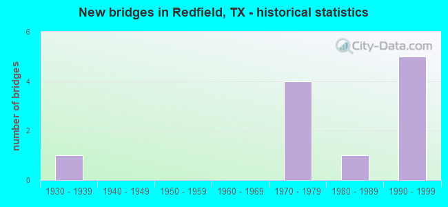
- New bridges - historical statistics
- 11930-1939
- 41970-1979
- 11980-1989
- 51990-1999
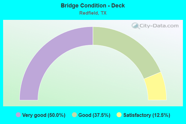
- Bridge Condition - Deck
- 50.0%Very good
- 37.5%Good
- 12.5%Satisfactory
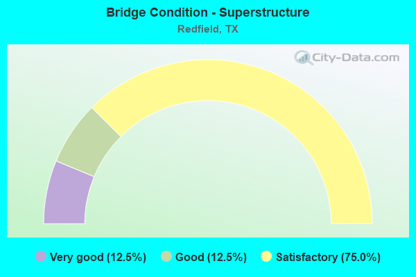
- Bridge Condition - Superstructure
- 12.5%Very good
- 12.5%Good
- 75.0%Satisfactory
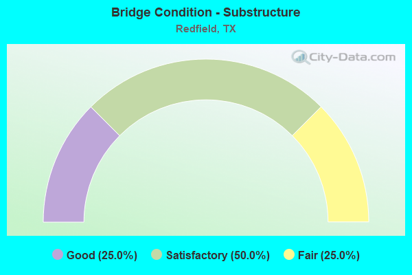
- Bridge Condition - Substructure
- 25.0%Good
- 50.0%Satisfactory
- 25.0%Fair
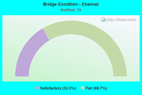
- Bridge Condition - Channel
- 33.3%Satisfactory
- 66.7%Fair
Find on map >> Show street view
Structure Number: 111740017507021, Location: 14.0 MI S OF RUSK CO LI (Lat: 31.703100, Lng: -94.640239), Route carried "on" structure: US 59, Year Built: 1935, Year Reconstructed: 1994, Status: Open, Structure Length: 1.34m (4.40ft), Average Daily Traffic: 12,754 (year 2019), Truck Traffic: 22%, Average Future Daily Traffic: 17,950 (year 2033), Features Intersected: BANITA CREEK
Minimum Vertical Clearance: 30+ m (98+ ft), Kilometerpoint: 22.577, Lanes on structure: 4, Owner: State Highway Agency, Approaching Roadway Width: 25.6m (84.0ft), Material/Design: Concrete, Design/Construction: Culvert, Number Of Spans In Main Unit: 4, Length of Maximum Span: 3.0m (9.8ft), Curb-To-Curb Width: 25.6m (84.0ft), Out-to-Out Width: 43.9m (144.0ft)
Condition: Channel: Fair, Culverts: Satisfactory, Operating Rating: 39.9 metric tons, Method Used To Determine Operating Rating: Load Factor (LF), Inventory Rating: 23.6 metric tons, Method Used To Determine Inventory Rating: Load Factor (LF), Structural Evaluation: Somewhat better than minimum adequacy, Deck Geometry: Superior to present desirable criteria, Waterway Adequacy: Superior to present desirable criteria, Approach Roadway Alignment: Equal to present desirable criteria, Designated Inspection Frequency: Every 24 months, Inspection Date: May 2020
Find on map >> Show street view
Structure Number: 111740017507079, Location: INT US 59 & US 259 (Lat: 31.681575, Lng: -94.665825), Route carried "on" structure: US 259, Year Built: 1970, Status: Open, Structure Length: 6.77m (22.21ft), Average Daily Traffic: 12,820 (year 2013), Truck Traffic: 24%, Average Future Daily Traffic: 17,950 (year 2033), Design Load: HS 20, Features Intersected: US 59
Minimum Vertical Clearance: 30+ m (98+ ft), Kilometerpoint: 18.379, Lanes on structure: 2, Lanes under structure: 4, Base Highway Network: Yes, Owner: State Highway Agency, Approaching Roadway Width: 11.6m (38.1ft), Skew: 2 degrees, Material/Design: Prestressed concrete, Design/Construction: Stringer/Multi-beam, Number Of Spans In Main Unit: 2, Number Of Approach Spans: 2, Length of Maximum Span: 21.6m (70.9ft), Curb-To-Curb Width: 12.4m (40.7ft), Out-to-Out Width: 12.9m (42.3ft)
Condition: Deck: Satisfactory, Superstructure: Satisfactory, Substructure: Good, Operating Rating: 62.6 metric tons, Method Used To Determine Operating Rating: Load Factor (LF), Inventory Rating: 32.7 metric tons, Method Used To Determine Inventory Rating: Load Factor (LF), Structural Evaluation: Equal to present minimum criteria, Deck Geometry: Better than present minimum criteria, Underclear: Equal to present minimum criteria, Approach Roadway Alignment: Equal to present desirable criteria, Designated Inspection Frequency: Every 24 months, Inspection Date: April 2020, Deck Structure Type: Concrete Cast-file-Place
Find on map >> Show street view
Structure Number: 111740256001025, Location: 4.0 MI N OF SH 21 (Lat: 31.670228, Lng: -94.672669), Route carried "on" structure: US 59, Year Built: 1984, Status: Open, Structure Length: 9.14m (29.99ft), Average Daily Traffic: 10,121 (year 2020), Truck Traffic: 23%, Average Future Daily Traffic: 27,900 (year 2033), Design Load: HS 20, Features Intersected: UPRR (ABANDONED)
Minimum Vertical Clearance: 30+ m (98+ ft), Kilometerpoint: 4.693, Lanes on structure: 2, Owner: State Highway Agency, Approaching Roadway Width: 11.0m (36.1ft), Skew: 4 degrees, Material/Design: Prestressed concrete, Design/Construction: Stringer/Multi-beam, Number Of Spans In Main Unit: 1, Number Of Approach Spans: 4, Length of Maximum Span: 23.2m (76.1ft), Curb-To-Curb Width: 10.9m (35.8ft), Out-to-Out Width: 11.6m (38.1ft)
Condition: Deck: Good, Superstructure: Very good, Substructure: Satisfactory, Operating Rating: 54.4 metric tons, Method Used To Determine Operating Rating: Assigned rating based on Load Factor Design (LFD) reported in metric tons, Inventory Rating: 32.7 metric tons, Method Used To Determine Inventory Rating: Assigned rating based on Load Factor Design (LFD) reported in metric tons, Structural Evaluation: Equal to present minimum criteria, Deck Geometry: Somewhat better than minimum adequacy, Underclear: Superior to present desirable criteria, Approach Roadway Alignment: Equal to present desirable criteria, Designated Inspection Frequency: Every 24 months, Inspection Date: April 2020, Deck Structure Type: Concrete Precast Panels
Find on map >> Show street view
Structure Number: 111740256001087, Location: INT US 59 & US 259 (Lat: 31.681814, Lng: -94.666431), Route carried "on" structure: US 259, Year Built: 1970, Status: Open, Structure Length: 6.77m (22.21ft), Average Daily Traffic: 19,930 (year 2013), Truck Traffic: 24%, Average Future Daily Traffic: 27,900 (year 2033), Design Load: HS 20, Features Intersected: US 59
Minimum Vertical Clearance: 30+ m (98+ ft), Kilometerpoint: 18.379, Lanes on structure: 2, Lanes under structure: 5, Base Highway Network: Yes, Owner: State Highway Agency, Approaching Roadway Width: 12.2m (40.0ft), Skew: 2 degrees, Material/Design: Prestressed concrete, Design/Construction: Stringer/Multi-beam, Number Of Spans In Main Unit: 2, Number Of Approach Spans: 2, Length of Maximum Span: 21.6m (70.9ft), Curb-To-Curb Width: 12.3m (40.4ft), Out-to-Out Width: 12.8m (42.0ft)
Condition: Deck: Good, Superstructure: Good, Substructure: Good, Operating Rating: 62.6 metric tons, Method Used To Determine Operating Rating: Load Factor (LF), Inventory Rating: 32.7 metric tons, Method Used To Determine Inventory Rating: Load Factor (LF), Structural Evaluation: Better than present minimum criteria, Deck Geometry: Better than present minimum criteria, Underclear: Equal to present minimum criteria, Approach Roadway Alignment: Equal to present desirable criteria, Designated Inspection Frequency: Every 24 months, Inspection Date: April 2020, Deck Structure Type: Concrete Cast-file-Place
Find on map >> Show street view
Structure Number: 111740AA0154001, Location: 1.4 MI N OF FM 698 (Lat: 31.717161, Lng: -94.710311), Route carried "on" structure: County highway 813, Year Built: 1993, Status: Open, Structure Length: 2.26m (7.41ft), Average Daily Traffic: 750 (year 2018), Average Future Daily Traffic: 50 (year 2033), Features Intersected: BAILEY CREEK
Minimum Vertical Clearance: 30+ m (98+ ft), Kilometerpoint: 2.253, Lanes on structure: 1, Owner: County Highway Agency, Approaching Roadway Width: 4.3m (14.1ft), Material/Design: Steel continuous, Design/Construction: Stringer/Multi-beam, Number Of Spans In Main Unit: 2, Number Of Approach Spans: 1, Length of Maximum Span: 7.3m (24.0ft), Curb-To-Curb Width: 4.4m (14.4ft), Out-to-Out Width: 4.9m (16.1ft)
Condition: Deck: Very good, Superstructure: Satisfactory, Substructure: Satisfactory, Channel: Fair, Operating Rating: 41.7 metric tons, Method Used To Determine Operating Rating: Allowable Stress (AS), Inventory Rating: 27.2 metric tons, Method Used To Determine Inventory Rating: Allowable Stress (AS), Structural Evaluation: Equal to present minimum criteria, Deck Geometry: High priority of replacement, Waterway Adequacy: Equal to present minimum criteria, Approach Roadway Alignment: Better than present minimum criteria, Designated Inspection Frequency: Every 24 months, Inspection Date: April 2021, Deck Structure Type: Wood or Timber, Wearing Surface/Protective System: Wearing Surface: Wood or Timber
Find on map >> Show street view
Structure Number: 111740AA0170001, Location: 0.8 MI W OF FM2864 (Lat: 31.711531, Lng: -94.649250), Route carried "on" structure: County highway 104, Year Built: 1992, Status: Open, Structure Length: 3.72m (12.20ft), Average Daily Traffic: 400 (year 2018), Average Future Daily Traffic: 165 (year 2033), Features Intersected: BANITA CREEK
Minimum Vertical Clearance: 30+ m (98+ ft), Kilometerpoint: 1.368, Lanes on structure: 1, Owner: County Highway Agency, Approaching Roadway Width: 4.6m (15.1ft), Material/Design: Steel continuous, Design/Construction: Stringer/Multi-beam, Number Of Spans In Main Unit: 4, Number Of Approach Spans: 1, Length of Maximum Span: 8.5m (27.9ft), Curb-To-Curb Width: 4.4m (14.4ft), Out-to-Out Width: 4.9m (16.1ft)
Condition: Deck: Very good, Superstructure: Satisfactory, Substructure: Satisfactory, Channel: Satisfactory, Operating Rating: 43.5 metric tons, Method Used To Determine Operating Rating: Allowable Stress (AS), Inventory Rating: 29.0 metric tons, Method Used To Determine Inventory Rating: Allowable Stress (AS), Structural Evaluation: Equal to present minimum criteria, Deck Geometry: High priority of replacement, Waterway Adequacy: Equal to present minimum criteria, Approach Roadway Alignment: Better than present minimum criteria, Designated Inspection Frequency: Every 24 months, Inspection Date: May 2021, Deck Structure Type: Wood or Timber, Wearing Surface/Protective System: Wearing Surface: Wood or Timber
Find on map >> Show street view
Structure Number: 111740AA0434001, Location: 0.4 MI WEST OF US 59 (Lat: 31.674597, Lng: -94.675711), Route carried "on" structure: County highway 809, Year Built: 1994, Status: Open, Structure Length: 2.23m (7.32ft), Average Daily Traffic: 100 (year 2018), Average Future Daily Traffic: 75 (year 2033), Features Intersected: BONITA CREEK
Minimum Vertical Clearance: 30+ m (98+ ft), Kilometerpoint: 0.644, Lanes on structure: 1, Owner: County Highway Agency, Approaching Roadway Width: 3.9m (12.8ft), Skew: 1 degrees, Material/Design: Steel continuous, Design/Construction: Stringer/Multi-beam, Number Of Spans In Main Unit: 2, Number Of Approach Spans: 1, Length of Maximum Span: 7.3m (24.0ft), Curb-To-Curb Width: 4.2m (13.8ft), Out-to-Out Width: 4.8m (15.7ft)
Condition: Deck: Good, Superstructure: Satisfactory, Substructure: Fair, Channel: Fair, Operating Rating: 59.9 metric tons, Method Used To Determine Operating Rating: Allowable Stress (AS), Inventory Rating: 36.3 metric tons, Method Used To Determine Inventory Rating: Allowable Stress (AS), Structural Evaluation: Somewhat better than minimum adequacy, Deck Geometry: Somewhat better than minimum adequacy, Waterway Adequacy: Equal to present minimum criteria, Approach Roadway Alignment: Equal to present minimum criteria, Designated Inspection Frequency: Every 24 months, Inspection Date: May 2021, Deck Structure Type: Wood or Timber, Wearing Surface/Protective System: Wearing Surface: Wood or Timber
Find on map >> Show street view
Structure Number: 111740AA0436001, Location: 1.4 MI W OF US 259 (Lat: 31.688042, Lng: -94.696000), Route carried "on" structure: County highway 810, Year Built: 1992, Status: Open, Structure Length: 1.52m (4.99ft), Average Daily Traffic: 100 (year 2018), Average Future Daily Traffic: 75 (year 2033), Features Intersected: BONITA CREEK
Minimum Vertical Clearance: 30+ m (98+ ft), Kilometerpoint: 2.092, Lanes on structure: 1, Owner: County Highway Agency, Approaching Roadway Width: 3.7m (12.1ft), Material/Design: Steel continuous, Design/Construction: Stringer/Multi-beam, Number Of Spans In Main Unit: 2, Length of Maximum Span: 8.2m (26.9ft), Curb-To-Curb Width: 4.4m (14.4ft), Out-to-Out Width: 4.9m (16.1ft)
Condition: Deck: Very good, Superstructure: Satisfactory, Substructure: Satisfactory, Channel: Satisfactory, Operating Rating: 38.1 metric tons, Method Used To Determine Operating Rating: Allowable Stress (AS), Inventory Rating: 25.4 metric tons, Method Used To Determine Inventory Rating: Allowable Stress (AS), Structural Evaluation: Equal to present minimum criteria, Deck Geometry: Equal to present minimum criteria, Waterway Adequacy: Equal to present minimum criteria, Approach Roadway Alignment: Equal to present minimum criteria, Designated Inspection Frequency: Every 24 months, Inspection Date: May 2021, Deck Structure Type: Wood or Timber, Wearing Surface/Protective System: Wearing Surface: Wood or Timber
Find on map >> Show street view
Structure Number: 111740AA0965001, Location: 0.5 MI E OF CR 205 (Lat: 31.668789, Lng: -94.649314), Route carried "on" structure: County highway 202, Year Built: 1993, Status: Open, Structure Length: 1.80m (5.91ft), Average Daily Traffic: 100 (year 2018), Average Future Daily Traffic: 75 (year 2033), Features Intersected: TOLIVER BRANCH
Minimum Vertical Clearance: 30+ m (98+ ft), Kilometerpoint: 0.805, Lanes on structure: 1, Owner: County Highway Agency, Approaching Roadway Width: 3.7m (12.1ft), Material/Design: Steel continuous, Design/Construction: Stringer/Multi-beam, Number Of Spans In Main Unit: 2, Number Of Approach Spans: 1, Length of Maximum Span: 7.3m (24.0ft), Curb-To-Curb Width: 4.4m (14.4ft), Out-to-Out Width: 4.9m (16.1ft)
Condition: Deck: Very good, Superstructure: Satisfactory, Substructure: Fair, Channel: Fair, Operating Rating: 44.4 metric tons, Method Used To Determine Operating Rating: Allowable Stress (AS), Inventory Rating: 29.0 metric tons, Method Used To Determine Inventory Rating: Allowable Stress (AS), Structural Evaluation: Somewhat better than minimum adequacy, Deck Geometry: Equal to present minimum criteria, Waterway Adequacy: Equal to present minimum criteria, Approach Roadway Alignment: Equal to present minimum criteria, Designated Inspection Frequency: Every 24 months, Inspection Date: May 2021, Deck Structure Type: Wood or Timber, Wearing Surface/Protective System: Wearing Surface: Wood or Timber
Find on map >> Show street view
Structure Number: 111740017507079, Location: INT US 59 & US 259 (Lat: 31.681575, Lng: -94.665825), Route carried "under" structure: US 59, Year Built: 1970, Structure Length: 0. m, Average Daily Traffic: 12,820 (year 2013), Truck Traffic: 22%, Features Intersected: US 59
Minimum Vertical Clearance: 4.95m (16.24ft), Kilometerpoint: 25.967, Lanes on structure: 2, Lanes under structure: 4, Material/Design: Prestressed concrete, Design/Construction: Stringer/Multi-beam, Length of Maximum Span: 21.6m (70.9ft)
Find on map >> Show street view
Structure Number: 111740256001087, Location: INT US 59 & US 259 (Lat: 31.681814, Lng: -94.666431), Route carried "under" structure: US 59, Year Built: 1970, Structure Length: 0. m, Average Daily Traffic: 19,930 (year 2013), Truck Traffic: 23%, Features Intersected: US 59
Minimum Vertical Clearance: 5.31m (17.42ft), Kilometerpoint: 4.828, Lanes on structure: 2, Lanes under structure: 5, Material/Design: Prestressed concrete, Design/Construction: Stringer/Multi-beam, Length of Maximum Span: 21.6m (70.9ft)