Bridge Statistics for Reevesville, South Carolina (SC)
Condition, Traffic, Stress, Structural Evaluation, Project Costs
- National Bridge Inventory (NBI) Statistics
- 12Number of bridges
- 85ft / 26.1mTotal length
- $850,000Total costs
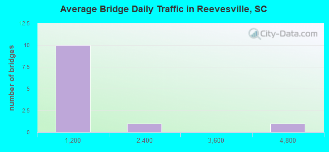
- 8,800Total average daily traffic
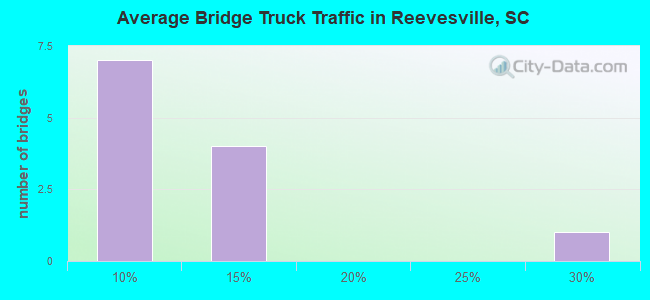
- 1,033Total average daily truck traffic
- 15,017Total future (year 2040) average daily traffic
- National Bridge Inventory (NBI) Registered Bridges for Reevesville
- No street view available for this location
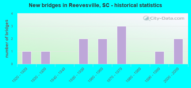
- New bridges - historical statistics
- 11920-1929
- 11930-1939
- 21950-1959
- 21960-1969
- 31970-1979
- 11990-1999
- 22000-2009
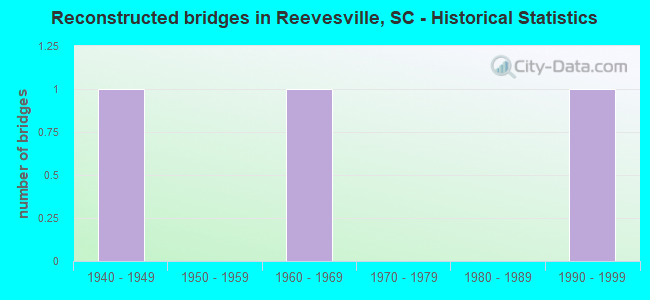
- Reconstructed bridges - Historical Statistics
- 11940-1949
- 01950-1959
- 11960-1969
- 01970-1979
- 01980-1989
- 11990-1999
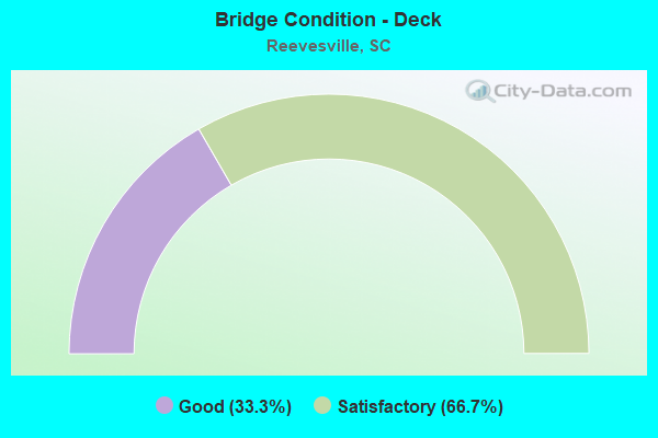
- Bridge Condition - Deck
- 33.3%Good
- 66.7%Satisfactory
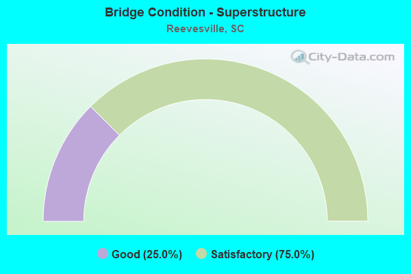
- Bridge Condition - Superstructure
- 25.0%Good
- 75.0%Satisfactory
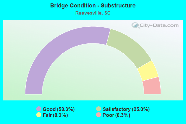
- Bridge Condition - Substructure
- 58.3%Good
- 25.0%Satisfactory
- 8.3%Fair
- 8.3%Poor
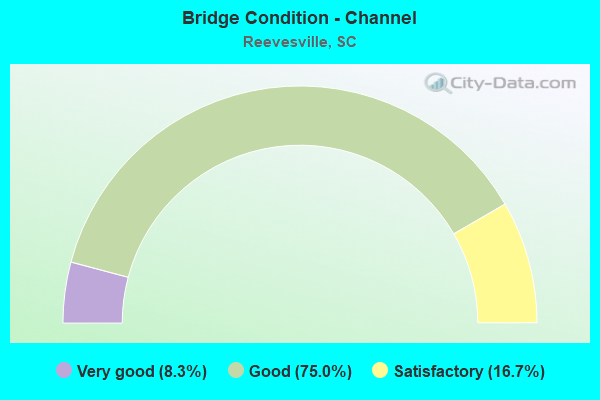
- Bridge Condition - Channel
- 8.3%Very good
- 75.0%Good
- 16.7%Satisfactory
Find on map >> Show street view
Structure Number: 24, Location: 7 MI NW OF ST GEORGE (Lat: 33.221936, Lng: -80.698136), Route carried "on" structure: US 78, Year Built: 1922, Year Reconstructed: 1951, Status: Open, Structure Length: 3.35m (10.99ft), Average Daily Traffic: 2,000 (year 2020), Truck Traffic: 26%, Average Future Daily Traffic: 3,480 (year 2040), Design Load: H 15, Features Intersected: CATTLE CREEK
Minimum Vertical Clearance: 30+ m (98+ ft), Kilometerpoint: 1.342, Lanes on structure: 2, Base Highway Network: Yes, Owner: State Highway Agency, Approaching Roadway Width: 7.0m (23.0ft), Material/Design: Concrete, Design/Construction: Tee Beam, Number Of Spans In Main Unit: 5, Length of Maximum Span: 6.7m (22.0ft), Curb or Sidewalk Widths: Left: 0.5m (1.6ft), Right: 0.5m (1.6ft), Curb-To-Curb Width: 7.9m (25.9ft), Out-to-Out Width: 8.9m (29.2ft)
Condition: Deck: Satisfactory, Superstructure: Satisfactory, Substructure: Satisfactory, Channel: Satisfactory, Operating Rating: 20.7 metric tons, Method Used To Determine Operating Rating: Load and Resistance Factor Rating (LRFR) rating reported by rating factor(RF) method using HL-93 loadings, Inventory Rating: 15.9 metric tons, Method Used To Determine Inventory Rating: Load and Resistance Factor Rating (LRFR) rating reported by rating factor(RF) method using HL-93 loadings, Structural Evaluation: Meets minimum limits, Deck Geometry: Meets minimum limits, Waterway Adequacy: Equal to present desirable criteria, Approach Roadway Alignment: Equal to present desirable criteria, Bridge Posting: Required (Relationship of Operating Rating to Maximum Legal Load: > 39.9% below), Length Of Structure Improvement: 4.22m (13.85ft), Designated Inspection Frequency: Every 24 months, Underwater Inspection Frequency: Every 60 months, Inspection Date: April 2020, Underwater Inspection Date: June 2021, Bridge Improvement Cost: $426,000, Roadway Improvement Cost: $107,000, Total Project Cost: $639,000 ( Estimate for 2021), Deck Structure Type: Concrete Cast-file-Place, Wearing Surface/Protective System: Wearing Surface: Bituminous
Find on map >> Show street view
Structure Number: 697, Location: 3 MI N OF CHAPIN (Lat: 34.186442, Lng: -81.296619), Route carried "on" structure: US 176, Year Built: 1935, Year Reconstructed: 1972, Status: Open, Structure Length: 3.72m (12.20ft), Average Daily Traffic: 3,800 (year 2021), Truck Traffic: 7%, Average Future Daily Traffic: 7,372 (year 2041), Design Load: H 15, Features Intersected: WATEREE CREEK
Minimum Vertical Clearance: 30+ m (98+ ft), Kilometerpoint: 5.922, Lanes on structure: 2, Owner: State Highway Agency, Approaching Roadway Width: 7.5m (24.6ft), Material/Design: Steel continuous, Design/Construction: Stringer/Multi-beam, Number Of Spans In Main Unit: 3, Length of Maximum Span: 15.2m (49.9ft), Curb-To-Curb Width: 13.4m (44.0ft), Out-to-Out Width: 14.4m (47.2ft)
Condition: Deck: Good, Superstructure: Satisfactory, Substructure: Good, Channel: Very good, Operating Rating: 28.2 metric tons, Method Used To Determine Operating Rating: Load and Resistance Factor Rating (LRFR) rating reported by rating factor(RF) method using HL-93 loadings, Inventory Rating: 21.4 metric tons, Method Used To Determine Inventory Rating: Load and Resistance Factor Rating (LRFR) rating reported by rating factor(RF) method using HL-93 loadings, Structural Evaluation: Somewhat better than minimum adequacy, Deck Geometry: Better than present minimum criteria, Waterway Adequacy: Superior to present desirable criteria, Approach Roadway Alignment: Equal to present desirable criteria, Length Of Structure Improvement: 3.72m (12.20ft), Designated Inspection Frequency: Every 24 months, Inspection Date: December 2021, Deck Structure Type: Concrete Cast-file-Place, Wearing Surface/Protective System: Wearing Surface: Bituminous
Find on map >> Show street view
Structure Number: 1873, Location: 4.6MI NW OF ST GEORGE (Lat: 33.212922, Lng: -80.644203), Route carried "on" structure: State highway 16, Year Built: 1952, Year Reconstructed: 1995, Status: Open, Structure Length: 1.28m (4.20ft), Average Daily Traffic: 500 (year 2020), Truck Traffic: 11%, Average Future Daily Traffic: 730 (year 2040), Design Load: H 10, Features Intersected: POLK SWAMP
Minimum Vertical Clearance: 30+ m (98+ ft), Kilometerpoint: 8.946, Lanes on structure: 2, Owner: State Highway Agency, Approaching Roadway Width: 5.7m (18.7ft), Material/Design: Concrete, Design/Construction: Slab, Number Of Spans In Main Unit: 3, Length of Maximum Span: 4.3m (14.1ft), Curb-To-Curb Width: 6.4m (21.0ft), Out-to-Out Width: 7.8m (25.6ft)
Condition: Deck: Satisfactory, Superstructure: Satisfactory, Substructure: Satisfactory, Channel: Good, Operating Rating: 22.0 metric tons, Method Used To Determine Operating Rating: Load and Resistance Factor Rating (LRFR) rating reported by rating factor(RF) method using HL-93 loadings, Inventory Rating: 17.2 metric tons, Method Used To Determine Inventory Rating: Load and Resistance Factor Rating (LRFR) rating reported by rating factor(RF) method using HL-93 loadings, Structural Evaluation: Somewhat better than minimum adequacy, Deck Geometry: High priority of corrective action, Waterway Adequacy: Equal to present minimum criteria, Approach Roadway Alignment: Equal to present desirable criteria, Bridge Posting: Required (Relationship of Operating Rating to Maximum Legal Load: 20.0 - 29.9% below), Length Of Structure Improvement: 1.96m (6.43ft), Designated Inspection Frequency: Every 24 months, Inspection Date: May 2021, Bridge Improvement Cost: $102,000, Roadway Improvement Cost: $26,000, Total Project Cost: $153,000 ( Estimate for 2021), Deck Structure Type: Concrete Precast Panels, Wearing Surface/Protective System: Wearing Surface: Bituminous
Find on map >> Show street view
Structure Number: 2331, Location: 4.6MI NW OF ST GEORGE (Lat: 33.213892, Lng: -80.643950), Route carried "on" structure: State highway 16, Year Built: 2004, Status: Open, Structure Length: 2.13m (6.99ft), Average Daily Traffic: 500 (year 2020), Truck Traffic: 11%, Average Future Daily Traffic: 730 (year 2040), Design Load: HS 20, Features Intersected: POLK SWAMP
Minimum Vertical Clearance: 30+ m (98+ ft), Kilometerpoint: 8.832, Lanes on structure: 2, Owner: State Highway Agency, Approaching Roadway Width: 5.7m (18.7ft), Material/Design: Prestressed concrete, Design/Construction: Box Beam or Girders - Multiple, Number Of Spans In Main Unit: 2, Length of Maximum Span: 12.2m (40.0ft), Curb-To-Curb Width: 10.1m (33.1ft), Out-to-Out Width: 11.0m (36.1ft)
Condition: Deck: Good, Superstructure: Good, Substructure: Good, Channel: Good, Operating Rating: 52.8 metric tons, Method Used To Determine Operating Rating: Load and Resistance Factor Rating (LRFR) rating reported by rating factor(RF) method using HL-93 loadings, Inventory Rating: 40.8 metric tons, Method Used To Determine Inventory Rating: Load and Resistance Factor Rating (LRFR) rating reported by rating factor(RF) method using HL-93 loadings, Structural Evaluation: Better than present minimum criteria, Deck Geometry: Equal to present minimum criteria, Waterway Adequacy: Equal to present minimum criteria, Approach Roadway Alignment: Equal to present desirable criteria, Length Of Structure Improvement: 2.13m (6.99ft), Designated Inspection Frequency: Every 24 months, Inspection Date: May 2021, Deck Structure Type: Concrete Precast Panels, Wearing Surface/Protective System: Wearing Surface: Bituminous
Find on map >> Show street view
Structure Number: 2332, Location: 8.4 MI W OF ST GEORGE (Lat: 33.215353, Lng: -80.709497), Route carried "on" structure: State highway 18, Year Built: 2004, Status: Open, Structure Length: 1.52m (4.99ft), Average Daily Traffic: 250 (year 2020), Truck Traffic: 5%, Average Future Daily Traffic: 320 (year 2040), Design Load: HS 20, Features Intersected: TRIB TO CATTLE CREEK
Minimum Vertical Clearance: 30+ m (98+ ft), Kilometerpoint: 0.874, Lanes on structure: 2, Owner: State Highway Agency, Approaching Roadway Width: 5.9m (19.4ft), Material/Design: Prestressed concrete, Design/Construction: Box Beam or Girders - Multiple, Number Of Spans In Main Unit: 1, Length of Maximum Span: 15.2m (49.9ft), Curb-To-Curb Width: 10.1m (33.1ft), Out-to-Out Width: 11.0m (36.1ft)
Condition: Deck: Good, Superstructure: Good, Substructure: Good, Channel: Good, Operating Rating: 41.8 metric tons, Method Used To Determine Operating Rating: Load and Resistance Factor Rating (LRFR) rating reported by rating factor(RF) method using HL-93 loadings, Inventory Rating: 25.3 metric tons, Method Used To Determine Inventory Rating: Load and Resistance Factor Rating (LRFR) rating reported by rating factor(RF) method using HL-93 loadings, Structural Evaluation: Equal to present minimum criteria, Deck Geometry: Better than present minimum criteria, Waterway Adequacy: Equal to present desirable criteria, Approach Roadway Alignment: Equal to present desirable criteria, Length Of Structure Improvement: 1.52m (4.99ft), Designated Inspection Frequency: Every 24 months, Inspection Date: April 2021, Deck Structure Type: Concrete Precast Panels, Wearing Surface/Protective System: Wearing Surface: Bituminous
Find on map >> Show street view
Structure Number: 2339, Location: 6.2 MI NW ST GEORGE (Lat: 33.237064, Lng: -80.656897), Route carried "on" structure: State highway 192, Year Built: 1956, Status: Open, Structure Length: 1.71m (5.61ft), Average Daily Traffic: 300 (year 2020), Truck Traffic: 7%, Average Future Daily Traffic: 438 (year 2040), Design Load: H 10, Features Intersected: POLK SWAMP
Minimum Vertical Clearance: 30+ m (98+ ft), Kilometerpoint: 1.461, Lanes on structure: 2, Owner: State Highway Agency, Approaching Roadway Width: 5.5m (18.0ft), Material/Design: Concrete, Design/Construction: Slab, Number Of Spans In Main Unit: 4, Length of Maximum Span: 4.3m (14.1ft), Curb or Sidewalk Widths: Left: 0.2m (0.7ft), Right: 0.2m (0.7ft), Curb-To-Curb Width: 7.3m (24.0ft), Out-to-Out Width: 7.8m (25.6ft)
Condition: Deck: Satisfactory, Superstructure: Satisfactory, Substructure: Good, Channel: Good, Operating Rating: 22.0 metric tons, Method Used To Determine Operating Rating: Load and Resistance Factor Rating (LRFR) rating reported by rating factor(RF) method using HL-93 loadings, Inventory Rating: 17.2 metric tons, Method Used To Determine Inventory Rating: Load and Resistance Factor Rating (LRFR) rating reported by rating factor(RF) method using HL-93 loadings, Structural Evaluation: Somewhat better than minimum adequacy, Deck Geometry: Somewhat better than minimum adequacy, Waterway Adequacy: Better than present minimum criteria, Approach Roadway Alignment: Equal to present desirable criteria, Bridge Posting: Required (Relationship of Operating Rating to Maximum Legal Load: 20.0 - 29.9% below), Length Of Structure Improvement: 1.71m (5.61ft), Designated Inspection Frequency: Every 24 months, Inspection Date: May 2021, Deck Structure Type: Concrete Precast Panels, Wearing Surface/Protective System: Wearing Surface: Bituminous
Find on map >> Show street view
Structure Number: 3636, Location: 3.5 MI W OF ST GEORGE (Lat: 33.191225, Lng: -80.629681), Route carried "on" structure: State highway 53, Year Built: 1961, Status: Open, Structure Length: 0.91m (2.99ft), Average Daily Traffic: 225 (year 2020), Truck Traffic: 10%, Average Future Daily Traffic: 313 (year 2040), Design Load: H 15, Features Intersected: BEAR BRANCH
Minimum Vertical Clearance: 30+ m (98+ ft), Kilometerpoint: 2.087, Lanes on structure: 2, Owner: State Highway Agency, Approaching Roadway Width: 6.1m (20.0ft), Material/Design: Concrete, Design/Construction: Slab, Number Of Spans In Main Unit: 2, Length of Maximum Span: 4.6m (15.1ft), Curb or Sidewalk Widths: Left: 0.2m (0.7ft), Right: 0.2m (0.7ft), Curb-To-Curb Width: 7.9m (25.9ft), Out-to-Out Width: 8.4m (27.6ft)
Condition: Deck: Satisfactory, Superstructure: Satisfactory, Substructure: Poor, Channel: Satisfactory, Operating Rating: 31.8 metric tons, Method Used To Determine Operating Rating: Load and Resistance Factor Rating (LRFR) rating reported by rating factor(RF) method using HL-93 loadings, Inventory Rating: 24.3 metric tons, Method Used To Determine Inventory Rating: Load and Resistance Factor Rating (LRFR) rating reported by rating factor(RF) method using HL-93 loadings, Structural Evaluation: Meets minimum limits, Deck Geometry: Somewhat better than minimum adequacy, Waterway Adequacy: Equal to present minimum criteria, Approach Roadway Alignment: Equal to present desirable criteria, Length Of Structure Improvement: 1.55m (5.09ft), Designated Inspection Frequency: Every 12 months, Underwater Inspection Frequency: Every 60 months, Inspection Date: April 2021, Underwater Inspection Date: June 2021, Bridge Improvement Cost: $53,000, Roadway Improvement Cost: $3,000, Total Project Cost: $58,000 ( Estimate for 2021), Deck Structure Type: Concrete Precast Panels, Wearing Surface/Protective System: Wearing Surface: Bituminous
Find on map >> Show street view
Structure Number: 4101, Location: 4.6MI SW OF ST GEORGE (Lat: 33.162319, Lng: -80.644556), Route carried "on" structure: State highway 16, Year Built: 1963, Status: Open, Structure Length: 1.37m (4.49ft), Average Daily Traffic: 250 (year 2020), Truck Traffic: 5%, Average Future Daily Traffic: 320 (year 2040), Design Load: H 15, Features Intersected: COW TAIL CREEK
Minimum Vertical Clearance: 30+ m (98+ ft), Kilometerpoint: 15.426, Lanes on structure: 2, Owner: State Highway Agency, Approaching Roadway Width: 5.8m (19.0ft), Material/Design: Concrete, Design/Construction: Slab, Number Of Spans In Main Unit: 3, Length of Maximum Span: 4.6m (15.1ft), Curb or Sidewalk Widths: Left: 0.2m (0.7ft), Right: 0.2m (0.7ft), Curb-To-Curb Width: 7.9m (25.9ft), Out-to-Out Width: 8.4m (27.6ft)
Condition: Deck: Satisfactory, Superstructure: Satisfactory, Substructure: Fair, Channel: Good, Operating Rating: 29.8 metric tons, Method Used To Determine Operating Rating: Load and Resistance Factor Rating (LRFR) rating reported by rating factor(RF) method using HL-93 loadings, Inventory Rating: 23.0 metric tons, Method Used To Determine Inventory Rating: Load and Resistance Factor Rating (LRFR) rating reported by rating factor(RF) method using HL-93 loadings, Structural Evaluation: Somewhat better than minimum adequacy, Deck Geometry: Somewhat better than minimum adequacy, Waterway Adequacy: Equal to present minimum criteria, Approach Roadway Alignment: Equal to present desirable criteria, Length Of Structure Improvement: 1.37m (4.49ft), Designated Inspection Frequency: Every 24 months, Inspection Date: April 2021, Deck Structure Type: Concrete Precast Panels, Wearing Surface/Protective System: Wearing Surface: Bituminous
Find on map >> Show street view
Structure Number: 6284, Location: 3.5 MI SW ST GEORGE (Lat: 33.162075, Lng: -80.624775), Route carried "on" structure: State highway 71, Year Built: 1973, Status: Open, Structure Length: 1.83m (6.00ft), Average Daily Traffic: 200 (year 2020), Truck Traffic: 7%, Average Future Daily Traffic: 278 (year 2040), Design Load: H 10, Features Intersected: COWTAIL CREEK
Minimum Vertical Clearance: 30+ m (98+ ft), Kilometerpoint: 4.064, Lanes on structure: 2, Owner: State Highway Agency, Approaching Roadway Width: 5.6m (18.4ft), Material/Design: Concrete, Design/Construction: Slab, Number Of Spans In Main Unit: 4, Length of Maximum Span: 4.6m (15.1ft), Curb-To-Curb Width: 9.6m (31.5ft), Out-to-Out Width: 10.1m (33.1ft)
Condition: Deck: Satisfactory, Superstructure: Satisfactory, Substructure: Good, Channel: Good, Operating Rating: 21.7 metric tons, Method Used To Determine Operating Rating: Load and Resistance Factor Rating (LRFR) rating reported by rating factor(RF) method using HL-93 loadings, Inventory Rating: 16.5 metric tons, Method Used To Determine Inventory Rating: Load and Resistance Factor Rating (LRFR) rating reported by rating factor(RF) method using HL-93 loadings, Structural Evaluation: Somewhat better than minimum adequacy, Deck Geometry: Equal to present minimum criteria, Waterway Adequacy: Better than present minimum criteria, Approach Roadway Alignment: Better than present minimum criteria, Bridge Posting: Required (Relationship of Operating Rating to Maximum Legal Load: 20.0 - 29.9% below), Length Of Structure Improvement: 1.83m (6.00ft), Designated Inspection Frequency: Every 24 months, Inspection Date: April 2021, Deck Structure Type: Concrete Precast Panels, Wearing Surface/Protective System: Wearing Surface: Bituminous
Find on map >> Show street view
Structure Number: 6656, Location: 4.5 MI SW ST GEORGE (Lat: 33.151694, Lng: -80.628231), Route carried "on" structure: State highway 71, Year Built: 1975, Status: Open, Structure Length: 1.37m (4.49ft), Average Daily Traffic: 200 (year 2020), Truck Traffic: 7%, Average Future Daily Traffic: 278 (year 2040), Design Load: H 15, Features Intersected: UNNAMED STREAM
Minimum Vertical Clearance: 30+ m (98+ ft), Kilometerpoint: 2.858, Lanes on structure: 2, Owner: State Highway Agency, Approaching Roadway Width: 5.5m (18.0ft), Material/Design: Concrete, Design/Construction: Slab, Number Of Spans In Main Unit: 3, Length of Maximum Span: 4.6m (15.1ft), Curb-To-Curb Width: 9.6m (31.5ft), Out-to-Out Width: 10.1m (33.1ft)
Condition: Deck: Good, Superstructure: Good, Substructure: Satisfactory, Channel: Good, Operating Rating: 30.1 metric tons, Method Used To Determine Operating Rating: Load and Resistance Factor Rating (LRFR) rating reported by rating factor(RF) method using HL-93 loadings, Inventory Rating: 23.3 metric tons, Method Used To Determine Inventory Rating: Load and Resistance Factor Rating (LRFR) rating reported by rating factor(RF) method using HL-93 loadings, Structural Evaluation: Equal to present minimum criteria, Deck Geometry: Equal to present minimum criteria, Waterway Adequacy: Equal to present minimum criteria, Approach Roadway Alignment: Equal to present desirable criteria, Length Of Structure Improvement: 1.37m (4.49ft), Designated Inspection Frequency: Every 24 months, Inspection Date: April 2021, Deck Structure Type: Concrete Precast Panels, Wearing Surface/Protective System: Wearing Surface: Bituminous
Find on map >> Show street view
Structure Number: 697, Location: 4.2 MI W ST GEORGE (Lat: 33.207303, Lng: -80.637033), Route carried "on" structure: State highway 471, Year Built: 1977, Status: Open, Structure Length: 1.37m (4.49ft), Average Daily Traffic: 375 (year 2020), Truck Traffic: 5%, Average Future Daily Traffic: 480 (year 2040), Design Load: H 10, Features Intersected: POLK SWAMP
Minimum Vertical Clearance: 30+ m (98+ ft), Kilometerpoint: 0.439, Lanes on structure: 2, Owner: State Highway Agency, Approaching Roadway Width: 5.9m (19.4ft), Skew: 10 degrees, Material/Design: Concrete, Design/Construction: Slab, Number Of Spans In Main Unit: 3, Length of Maximum Span: 4.6m (15.1ft), Curb-To-Curb Width: 9.6m (31.5ft), Out-to-Out Width: 10.1m (33.1ft)
Condition: Deck: Satisfactory, Superstructure: Satisfactory, Substructure: Good, Channel: Good, Operating Rating: 21.7 metric tons, Method Used To Determine Operating Rating: Load and Resistance Factor Rating (LRFR) rating reported by rating factor(RF) method using HL-93 loadings, Inventory Rating: 16.5 metric tons, Method Used To Determine Inventory Rating: Load and Resistance Factor Rating (LRFR) rating reported by rating factor(RF) method using HL-93 loadings, Structural Evaluation: Somewhat better than minimum adequacy, Deck Geometry: Equal to present minimum criteria, Waterway Adequacy: Equal to present minimum criteria, Approach Roadway Alignment: Equal to present desirable criteria, Bridge Posting: Required (Relationship of Operating Rating to Maximum Legal Load: 20.0 - 29.9% below), Length Of Structure Improvement: 1.37m (4.49ft), Designated Inspection Frequency: Every 24 months, Inspection Date: May 2021, Deck Structure Type: Concrete Precast Panels, Wearing Surface/Protective System: Wearing Surface: Bituminous
Find on map >> Show street view
Structure Number: 8735, Location: 8.4MI W OF ST GEORGE (Lat: 33.198583, Lng: -80.692625), Route carried "on" structure: State highway 18, Year Built: 1994, Status: Open, Structure Length: 5.49m (18.01ft), Average Daily Traffic: 200 (year 2020), Truck Traffic: 12%, Average Future Daily Traffic: 278 (year 2040), Design Load: HS 20, Features Intersected: CATTLE CREEK
Minimum Vertical Clearance: 30+ m (98+ ft), Kilometerpoint: 3.537, Lanes on structure: 2, Owner: State Highway Agency, Approaching Roadway Width: 6.1m (20.0ft), Material/Design: Concrete continuous, Design/Construction: Slab, Number Of Spans In Main Unit: 6, Length of Maximum Span: 9.1m (29.9ft), Curb-To-Curb Width: 9.1m (29.9ft), Out-to-Out Width: 10.1m (33.1ft)
Condition: Deck: Satisfactory, Superstructure: Satisfactory, Substructure: Good, Channel: Good, Operating Rating: 52.5 metric tons, Method Used To Determine Operating Rating: Load and Resistance Factor Rating (LRFR) rating reported by rating factor(RF) method using HL-93 loadings, Inventory Rating: 40.5 metric tons, Method Used To Determine Inventory Rating: Load and Resistance Factor Rating (LRFR) rating reported by rating factor(RF) method using HL-93 loadings, Structural Evaluation: Equal to present minimum criteria, Deck Geometry: Equal to present minimum criteria, Waterway Adequacy: Equal to present desirable criteria, Approach Roadway Alignment: Better than present minimum criteria, Length Of Structure Improvement: 5.49m (18.01ft), Designated Inspection Frequency: Every 24 months, Inspection Date: Febuary 2021, Deck Structure Type: Concrete Precast Panels, Wearing Surface/Protective System: Wearing Surface: Monolithic Concrete