Bridge Statistics for Richton Park, Illinois (IL)
Condition, Traffic, Stress, Structural Evaluation, Project Costs
- National Bridge Inventory (NBI) Statistics
- 10Number of bridges
- 112ft / 34.3mTotal length
- 204,900Total average daily traffic
- 25,759Total average daily truck traffic
- National Bridge Inventory (NBI) Registered Bridges for Richton Park
- No street view available for this location
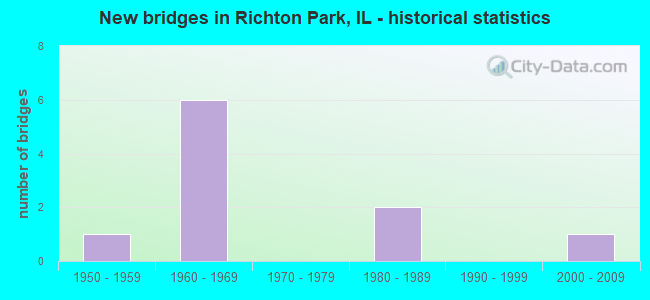
- New bridges - historical statistics
- 11950-1959
- 61960-1969
- 21980-1989
- 12000-2009
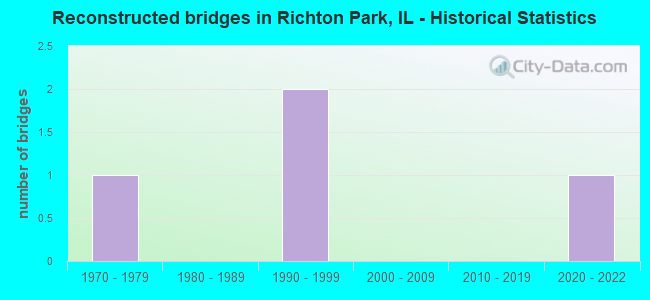
- Reconstructed bridges - Historical Statistics
- 11970-1979
- 01980-1989
- 21990-1999
- 02000-2009
- 02010-2019
- 12020-2022

- Bridge Condition - Deck
- 33.3%Excellent
- 66.7%Fair
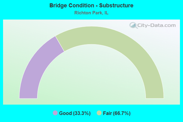
- Bridge Condition - Substructure
- 33.3%Good
- 66.7%Fair
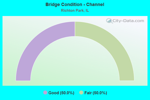
- Bridge Condition - Channel
- 50.0%Good
- 50.0%Fair
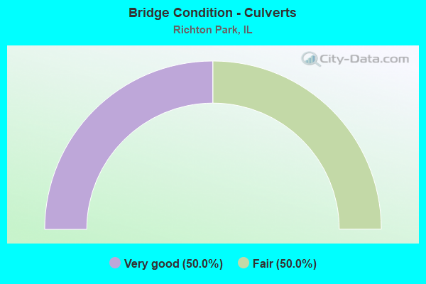
- Bridge Condition - Culverts
- 50.0%Very good
- 50.0%Fair
Find on map >> Show street view
Structure Number: 160048, Location: 1 M S US 30 (Lat: 41.491261, Lng: -87.743994), Route carried "on" structure: Interstate 57, Year Built: 1966, Year Reconstructed: 1996, Status: Open, Structure Length: 12.65m (41.50ft), Average Daily Traffic: 33,000 (year 2021), Truck Traffic: 17%, Average Future Daily Traffic: 20,806 (year 2032), Design Load: HS 20, Features Intersected: RR - EJ&E
Minimum Vertical Clearance: 30+ m (98+ ft), Kilometerpoint: 546.647, Lanes on structure: 2, Base Highway Network: Yes, Owner: State Highway Agency, Approaching Roadway Width: 12.2m (40.0ft), Skew: 1 degrees, Material/Design: Steel continuous, Design/Construction: Stringer/Multi-beam, Number Of Spans In Main Unit: 6, Length of Maximum Span: 25.2m (82.7ft), Curb-To-Curb Width: 12.2m (40.0ft), Out-to-Out Width: 13.2m (43.3ft)
Condition: Deck: Fair, Superstructure: Fair, Substructure: Fair, Operating Rating: 74.8 metric tons, Method Used To Determine Operating Rating: Load Factor (LF) rating reported by rating factor (RF) method using MS18 loading, Inventory Rating: 44.7 metric tons, Method Used To Determine Inventory Rating: Load Factor (LF) rating reported by rating factor (RF) method using MS18 loading, Structural Evaluation: Somewhat better than minimum adequacy, Deck Geometry: Better than present minimum criteria, Underclear: Equal to present desirable criteria, Approach Roadway Alignment: Equal to present desirable criteria, Designated Inspection Frequency: Every 24 months, Inspection Date: May 2020, Deck Structure Type: Concrete Cast-file-Place, Wearing Surface/Protective System: Deck Protection: Epoxy Coated Reinforcing
Find on map >> Show street view
Structure Number: 160049, Location: 1 M S US 30 (Lat: 41.491119, Lng: -87.744033), Route carried "on" structure: Interstate 57, Year Built: 1966, Year Reconstructed: 1996, Status: Open, Structure Length: 12.65m (41.50ft), Average Daily Traffic: 33,000 (year 2021), Truck Traffic: 17%, Average Future Daily Traffic: 20,806 (year 2032), Design Load: HS 20+Mod, Features Intersected: RR - EJ&E
Minimum Vertical Clearance: 30+ m (98+ ft), Kilometerpoint: 546.631, Lanes on structure: 2, Base Highway Network: Yes, Owner: State Highway Agency, Approaching Roadway Width: 12.2m (40.0ft), Skew: 1 degrees, Material/Design: Steel continuous, Design/Construction: Stringer/Multi-beam, Number Of Spans In Main Unit: 6, Length of Maximum Span: 25.2m (82.7ft), Curb-To-Curb Width: 12.2m (40.0ft), Out-to-Out Width: 13.2m (43.3ft)
Condition: Deck: Fair, Superstructure: Fair, Substructure: Fair, Operating Rating: 74.8 metric tons, Method Used To Determine Operating Rating: Load Factor (LF) rating reported by rating factor (RF) method using MS18 loading, Inventory Rating: 44.7 metric tons, Method Used To Determine Inventory Rating: Load Factor (LF) rating reported by rating factor (RF) method using MS18 loading, Structural Evaluation: Somewhat better than minimum adequacy, Deck Geometry: Better than present minimum criteria, Underclear: Superior to present desirable criteria, Approach Roadway Alignment: Equal to present desirable criteria, Designated Inspection Frequency: Every 24 months, Inspection Date: May 2020, Deck Structure Type: Concrete Cast-file-Place, Wearing Surface/Protective System: Deck Protection: Epoxy Coated Reinforcing
Find on map >> Show street view
Structure Number: 160575, Location: 1.6 M S US 30 (Lat: 41.484319, Lng: -87.747050), Route carried "on" structure: Other road , Year Built: 1966, Year Reconstructed: 2020, Status: Open, Structure Length: 7.41m (24.31ft), Average Daily Traffic: 10,800 (year 2018), Truck Traffic: 9%, Average Future Daily Traffic: 10,815 (year 2032), Design Load: HS 20, Features Intersected: I- 57, Facility Carried by Structure: SAUK TRAIL
Minimum Vertical Clearance: 30+ m (98+ ft), Kilometerpoint: 3.476, Lanes on structure: 4, Lanes under structure: 12, Base Highway Network: Yes, Owner: State Highway Agency, Approaching Roadway Width: 16.5m (54.1ft), Skew: 31 degrees, Material/Design: Steel continuous, Design/Construction: Stringer/Multi-beam, Number Of Spans In Main Unit: 2, Number Of Approach Spans: 2, Length of Maximum Span: 27.2m (89.2ft), Curb or Sidewalk Widths: Left: 1.5m (4.9ft), Right: 1.5m (4.9ft), Curb-To-Curb Width: 16.8m (55.1ft), Out-to-Out Width: 25.0m (82.0ft)
Condition: Deck: Excellent, Superstructure: Fair, Substructure: Good, Operating Rating: 51.5 metric tons, Method Used To Determine Operating Rating: Load Factor (LF) rating reported by rating factor (RF) method using MS18 loading, Inventory Rating: 30.8 metric tons, Method Used To Determine Inventory Rating: Load Factor (LF) rating reported by rating factor (RF) method using MS18 loading, Structural Evaluation: Somewhat better than minimum adequacy, Deck Geometry: Somewhat better than minimum adequacy, Underclear: High priority of corrective action, Approach Roadway Alignment: Equal to present desirable criteria, Designated Inspection Frequency: Every 24 months, Inspection Date: December 2020, Deck Structure Type: Concrete Cast-file-Place, Wearing Surface/Protective System: Deck Protection: Epoxy Coated Reinforcing
Find on map >> Show street view
Structure Number: 161278, Location: 1.6 M S OF US 30 (Lat: 41.482750, Lng: -87.732356), Route carried "on" structure: State highway 50, Year Built: 1950, Year Reconstructed: 1970, Status: Open, Structure Length: 0.77m (2.53ft), Average Daily Traffic: 8,300 (year 2021), Truck Traffic: 5%, Average Future Daily Traffic: 17,819 (year 2032), Features Intersected: LAKE GEORGE OVERFLOW
Minimum Vertical Clearance: 30+ m (98+ ft), Kilometerpoint: 45.463, Lanes on structure: 4, Base Highway Network: Yes, Owner: State Highway Agency, Approaching Roadway Width: 14.6m (47.9ft), Skew: 4 degrees, Material/Design: Concrete continuous, Design/Construction: Culvert, Number Of Spans In Main Unit: 2, Length of Maximum Span: 3.0m (9.8ft)
Condition: Channel: Good, Culverts: Fair, Operating Rating: 43.1 metric tons, Method Used To Determine Operating Rating: Field evaluation and documented engineering judgment, Inventory Rating: 25.9 metric tons, Method Used To Determine Inventory Rating: Field evaluation and documented engineering judgment, Structural Evaluation: Somewhat better than minimum adequacy, Waterway Adequacy: Superior to present desirable criteria, Approach Roadway Alignment: Equal to present desirable criteria, Designated Inspection Frequency: Every 24 months, Inspection Date: April 2021
Find on map >> Show street view
Structure Number: 163268, Location: .20M W CENTRAL AV (Lat: 41.484336, Lng: -87.755294), Route carried "on" structure: Other road , Year Built: 2001, Status: Open, Structure Length: 0.86m (2.82ft), Average Daily Traffic: 5,400 (year 2018), Truck Traffic: 9%, Average Future Daily Traffic: 5,408 (year 2032), Design Load: HS 20, Features Intersected: HICKORY CREEK, Facility Carried by Structure: SAUK TRAIL RD
Minimum Vertical Clearance: 30+ m (98+ ft), Kilometerpoint: 2.913, Lanes on structure: 2, Base Highway Network: Yes, Owner: County Highway Agency, Approaching Roadway Width: 19.5m (64.0ft), Skew: 20 degrees, Material/Design: Concrete, Design/Construction: Culvert, Number Of Spans In Main Unit: 3, Length of Maximum Span: 3.0m (9.8ft)
Condition: Channel: Fair, Culverts: Very good, Operating Rating: 44.1 metric tons, Method Used To Determine Operating Rating: Assigned rating based on Load Factor Design (LFD) reported by rating factor (RF) using MS18 loading, Inventory Rating: 32.4 metric tons, Method Used To Determine Inventory Rating: Assigned rating based on Load Factor Design (LFD) reported by rating factor (RF) using MS18 loading, Structural Evaluation: Equal to present desirable criteria, Waterway Adequacy: Superior to present desirable criteria, Approach Roadway Alignment: Equal to present desirable criteria, Designated Inspection Frequency: Every 48 months, Inspection Date: June 2021
Find on map >> Show street view
Structure Number: 160575, Location: 1.6 M S US 30 (Lat: 41.484319, Lng: -87.746331), Route carried "under" structure: Other road , Year Built: 1966, Structure Length: 0. m, Average Daily Traffic: 100 (year 2001), Features Intersected: I- 57, Facility Carried by Structure: SAUK TRAIL
Minimum Vertical Clearance: 4.80m (15.75ft), Kilometerpoint: 0.177, Lanes on structure: 4, Lanes under structure: 4, Material/Design: Steel continuous, Design/Construction: Stringer/Multi-beam, Length of Maximum Span: 27.2m (89.2ft)
Find on map >> Show street view
Structure Number: 160575, Location: 1.6 M S US 30 (Lat: 41.484319, Lng: -87.746867), Route carried "under" structure: Other road , Year Built: 1966, Structure Length: 0. m, Average Daily Traffic: 100 (year 2001), Features Intersected: I- 57, Facility Carried by Structure: SAUK TRAIL
Minimum Vertical Clearance: 4.80m (15.75ft), Kilometerpoint: 0.113, Lanes on structure: 4, Lanes under structure: 4, Material/Design: Steel continuous, Design/Construction: Stringer/Multi-beam, Length of Maximum Span: 27.2m (89.2ft)
Find on map >> Show street view
Structure Number: 160575, Location: 1.6 M S US 30 (Lat: 41.484319, Lng: -87.746439), Route carried "under" structure: Interstate 57, Year Built: 1966, Structure Length: 0. m, Average Daily Traffic: 66,000 (year 2021), Truck Traffic: 17%, Features Intersected: I- 57, Facility Carried by Structure: SAUK TRAIL
Minimum Vertical Clearance: 4.80m (15.75ft), Kilometerpoint: 545.858, Lanes on structure: 4, Lanes under structure: 4, Material/Design: Steel continuous, Design/Construction: Stringer/Multi-beam, Length of Maximum Span: 27.2m (89.2ft)
Find on map >> Show street view
Structure Number: 163207, Location: 1.2 MI E CICERO AVE (Lat: 41.484336, Lng: -87.709683), Route carried "under" structure: Other road , Year Built: 1983, Structure Length: 0. m, Average Daily Traffic: 24,100 (year 2018), Truck Traffic: 3%, Features Intersected: SAUK TRAIL, Facility Carried by Structure: I.C.G. RR MAIN LIN
Minimum Vertical Clearance: 5.49m (18.01ft), Kilometerpoint: 6.759, Lanes under structure: 4, Material/Design: Steel, Design/Construction: Stringer/Multi-beam, Length of Maximum Span: 18.6m (61.0ft)
Find on map >> Show street view
Structure Number: 163208, Location: 1.2 MI E CICERO AVE (Lat: 41.484333, Lng: -87.709847), Route carried "under" structure: Other road , Year Built: 1983, Structure Length: 0. m, Average Daily Traffic: 24,100 (year 2018), Truck Traffic: 3%, Features Intersected: SAUK TRAIL, Facility Carried by Structure: I.C.G.RR COMMUTER
Minimum Vertical Clearance: 5.49m (18.01ft), Kilometerpoint: 6.743, Lanes under structure: 4, Material/Design: Steel, Design/Construction: Stringer/Multi-beam, Length of Maximum Span: 18.6m (61.0ft)