Bridge Statistics for Richwood, New Jersey (NJ)
Condition, Traffic, Stress, Structural Evaluation, Project Costs
- National Bridge Inventory (NBI) Statistics
- 11Number of bridges
- 125ft / 38.0mTotal length
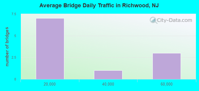
- 214,594Total average daily traffic
- 9,535Total average daily truck traffic
- National Bridge Inventory (NBI) Registered Bridges for Richwood
- No street view available for this location
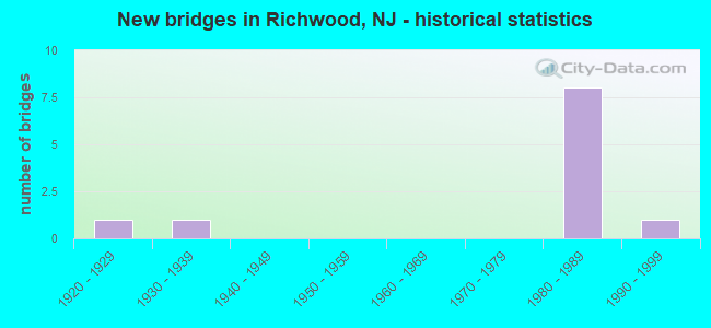
- New bridges - historical statistics
- 11920-1929
- 11930-1939
- 81980-1989
- 11990-1999
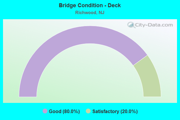
- Bridge Condition - Deck
- 80.0%Good
- 20.0%Satisfactory
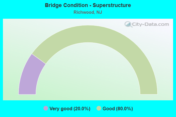
- Bridge Condition - Superstructure
- 20.0%Very good
- 80.0%Good
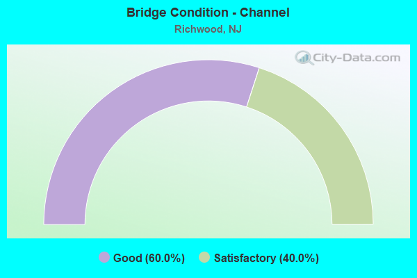
- Bridge Condition - Channel
- 60.0%Good
- 40.0%Satisfactory
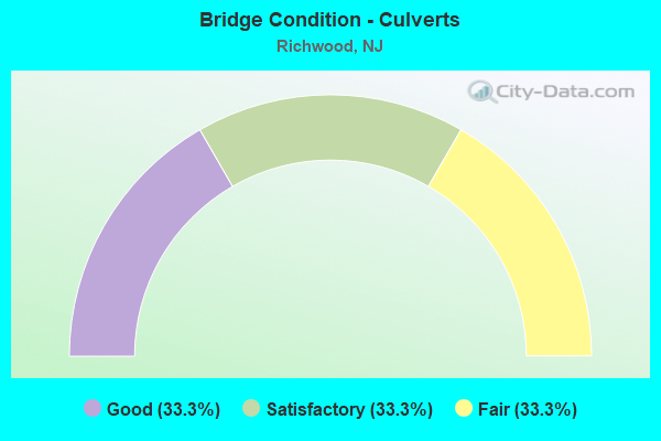
- Bridge Condition - Culverts
- 33.3%Good
- 33.3%Satisfactory
- 33.3%Fair
Find on map >> Show street view
Structure Number: 804H09, Location: 0.8 mi East of NJ RT 45 (Lat: 39.766269, Lng: -75.189731), Route carried "on" structure: County highway 626, Year Built: 1983, Status: Open, Structure Length: 1.74m (5.71ft), Average Daily Traffic: 1,151 (year 2020), Truck Traffic: 3%, Average Future Daily Traffic: 1,381 (year 2040), Design Load: HS 20+Mod, Features Intersected: EDWARDS RUN
Minimum Vertical Clearance: 30+ m (98+ ft), Kilometerpoint: 1.255, Lanes on structure: 2, Owner: County Highway Agency, Approaching Roadway Width: 9.1m (29.9ft), Material/Design: Wood or Timber, Design/Construction: Stringer/Multi-beam, Number Of Spans In Main Unit: 1, Length of Maximum Span: 17.1m (56.1ft), Curb-To-Curb Width: 10.5m (34.4ft), Out-to-Out Width: 11.2m (36.7ft)
Condition: Deck: Good, Superstructure: Good, Substructure: Good, Channel: Satisfactory, Operating Rating: 78.9 metric tons, Method Used To Determine Operating Rating: Allowable Stress (AS), Inventory Rating: 54.4 metric tons, Method Used To Determine Inventory Rating: Allowable Stress (AS), Structural Evaluation: Better than present minimum criteria, Deck Geometry: Equal to present minimum criteria, Waterway Adequacy: Equal to present desirable criteria, Approach Roadway Alignment: Equal to present desirable criteria, Designated Inspection Frequency: Every 24 months, Inspection Date: April 2020, Deck Structure Type: Wood or Timber, Wearing Surface/Protective System: Wearing Surface: Bituminous, Membrane: Other
Find on map >> Show street view
Structure Number: 805H03, Location: 1.3 mi East of NJ RT 45 (Lat: 39.754981, Lng: -75.190981), Route carried "on" structure: County highway 603, Year Built: 1998, Status: Open, Structure Length: 0.76m (2.49ft), Average Daily Traffic: 9,503 (year 2020), Truck Traffic: 3%, Average Future Daily Traffic: 11,746 (year 2020), Features Intersected: EDWARDS RUN
Minimum Vertical Clearance: 30+ m (98+ ft), Kilometerpoint: 2.044, Lanes on structure: 2, Owner: County Highway Agency, Approaching Roadway Width: 8.5m (27.9ft), Material/Design: Aluminum, Iron, Design/Construction: Culvert, Number Of Spans In Main Unit: 2, Length of Maximum Span: 3.0m (9.8ft)
Condition: Channel: Good, Culverts: Good, Operating Rating: 84.4 metric tons, Method Used To Determine Operating Rating: Load Factor (LF), Inventory Rating: 54.4 metric tons, Method Used To Determine Inventory Rating: Load Factor (LF), Structural Evaluation: Better than present minimum criteria, Waterway Adequacy: Equal to present desirable criteria, Approach Roadway Alignment: Equal to present desirable criteria, Designated Inspection Frequency: Every 24 months, Inspection Date: April 2020
Find on map >> Show street view
Structure Number: 806G06, Location: 0.28m E 77&1.6m S 322 (Lat: 39.708711, Lng: -75.200931), Route carried "on" structure: County highway 618, Year Built: 1985, Status: Open, Structure Length: 1.86m (6.10ft), Average Daily Traffic: 8,159 (year 2020), Truck Traffic: 1%, Average Future Daily Traffic: 9,791 (year 2040), Design Load: HS 20, Features Intersected: RACCOON CREEK
Minimum Vertical Clearance: 30+ m (98+ ft), Kilometerpoint: 2.623, Lanes on structure: 2, Owner: County Highway Agency, Approaching Roadway Width: 10.4m (34.1ft), Material/Design: Prestressed concrete, Design/Construction: Box Beam or Girders - Multiple, Number Of Spans In Main Unit: 1, Length of Maximum Span: 18.3m (60.0ft), Curb-To-Curb Width: 12.2m (40.0ft), Out-to-Out Width: 13.1m (43.0ft)
Condition: Deck: Good, Superstructure: Good, Substructure: Good, Channel: Good, Inventory Rating: 64.4 metric tons, Method Used To Determine Inventory Rating: Load Factor (LF), Structural Evaluation: Better than present minimum criteria, Deck Geometry: Somewhat better than minimum adequacy, Waterway Adequacy: Equal to present desirable criteria, Approach Roadway Alignment: Equal to present desirable criteria, Designated Inspection Frequency: Every 24 months, Inspection Date: October 2020, Deck Structure Type: Concrete Precast Panels, Wearing Surface/Protective System: Wearing Surface: Bituminous
Find on map >> Show street view
Structure Number: 806H05, Location: 2.0 mi. West of US RT 322 (Lat: 39.707289, Lng: -75.190250), Route carried "on" structure: County highway 623, Year Built: 1926, Status: Open, Structure Length: 0.61m (2.00ft), Average Daily Traffic: 900 (year 2020), Truck Traffic: 4%, Average Future Daily Traffic: 1,080 (year 2040), Features Intersected: CLEMS RUN
Minimum Vertical Clearance: 30+ m (98+ ft), Kilometerpoint: 3.187, Lanes on structure: 2, Owner: County Highway Agency, Approaching Roadway Width: 9.1m (29.9ft), Material/Design: Concrete, Design/Construction: Culvert, Number Of Spans In Main Unit: 1, Length of Maximum Span: 6.1m (20.0ft), Curb-To-Curb Width: 8.8m (28.9ft), Out-to-Out Width: 10.1m (33.1ft)
Condition: Channel: Good, Culverts: Satisfactory, Structural Evaluation: Equal to present minimum criteria, Deck Geometry: Somewhat better than minimum adequacy, Waterway Adequacy: Somewhat better than minimum adequacy, Approach Roadway Alignment: Equal to present desirable criteria, Designated Inspection Frequency: Every 24 months, Inspection Date: April 2020
Find on map >> Show street view
Structure Number: 807H01, Location: 0.35 MI West of CR 623 (Lat: 39.697650, Lng: -75.192919), Route carried "on" structure: County highway 622, Year Built: 1938, Status: Open, Structure Length: 0.61m (2.00ft), Average Daily Traffic: 3,047 (year 2020), Truck Traffic: 1%, Average Future Daily Traffic: 3,656 (year 2040), Features Intersected: RACCOON CR @ EWAN LAKE
Minimum Vertical Clearance: 30+ m (98+ ft), Kilometerpoint: 0.002, Lanes on structure: 2, Owner: County Highway Agency, Approaching Roadway Width: 8.2m (26.9ft), Material/Design: Concrete, Design/Construction: Culvert, Number Of Spans In Main Unit: 1, Length of Maximum Span: 6.1m (20.0ft), Curb-To-Curb Width: 9.0m (29.5ft), Out-to-Out Width: 10.2m (33.5ft)
Condition: Channel: Satisfactory, Culverts: Fair, Structural Evaluation: Somewhat better than minimum adequacy, Deck Geometry: Meets minimum limits, Waterway Adequacy: Somewhat better than minimum adequacy, Approach Roadway Alignment: Equal to present desirable criteria, Designated Inspection Frequency: Every 24 months, Inspection Date: April 2020
Find on map >> Show street view
Structure Number: 828186, Location: 5.9 MI SOUTH OF NJ 47 JCT (Lat: 39.719239, Lng: -75.154850), Route carried "on" structure: US 322, Year Built: 1989, Status: Open, Structure Length: 8.14m (26.71ft), Average Daily Traffic: 23,614 (year 2019), Truck Traffic: 4%, Average Future Daily Traffic: 28,814 (year 2039), Design Load: HS 20+Mod, Features Intersected: NJ ROUTE 55
Minimum Vertical Clearance: 30+ m (98+ ft), Kilometerpoint: 24.221, Lanes on structure: 6, Lanes under structure: 6, Base Highway Network: Yes, Owner: State Highway Agency, Approaching Roadway Width: 23.8m (78.1ft), Material/Design: Steel continuous, Design/Construction: Stringer/Multi-beam, Number Of Spans In Main Unit: 2, Length of Maximum Span: 40.2m (131.9ft), Curb or Sidewalk Widths: Left: 1.8m (5.9ft), Right: 1.8m (5.9ft), Curb-To-Curb Width: 23.8m (78.1ft), Out-to-Out Width: 28.0m (91.9ft)
Condition: Deck: Satisfactory, Superstructure: Good, Substructure: Good, Operating Rating: 80.7 metric tons, Method Used To Determine Operating Rating: Load Factor (LF), Inventory Rating: 48.1 metric tons, Method Used To Determine Inventory Rating: Load Factor (LF), Structural Evaluation: Better than present minimum criteria, Deck Geometry: Somewhat better than minimum adequacy, Underclear: Equal to present minimum criteria, Approach Roadway Alignment: Equal to present desirable criteria, Designated Inspection Frequency: Every 24 months, Inspection Date: October 2021, Deck Structure Type: Concrete Cast-file-Place, Wearing Surface/Protective System: Wearing Surface: Latex Concrete, Deck Protection: Epoxy Coated Reinforcing
Find on map >> Show street view
Structure Number: 828187, Location: 0.73MILE NORTH OF U.S 322 (Lat: 39.730300, Lng: -75.151489), Route carried "on" structure: County highway 635, Year Built: 1988, Status: Open, Structure Length: 16.40m (53.81ft), Average Daily Traffic: 4,249 (year 2020), Truck Traffic: 3%, Average Future Daily Traffic: 5,099 (year 2040), Design Load: HS 20+Mod, Features Intersected: NJ 55
Minimum Vertical Clearance: 30+ m (98+ ft), Kilometerpoint: 1.416, Lanes on structure: 2, Lanes under structure: 4, Owner: State Highway Agency, Approaching Roadway Width: 12.2m (40.0ft), Skew: 6 degrees, Material/Design: Steel continuous, Design/Construction: Stringer/Multi-beam, Number Of Spans In Main Unit: 4, Length of Maximum Span: 64.0m (210.0ft), Curb or Sidewalk Widths: Left: 1.8m (5.9ft), Right: 1.8m (5.9ft), Curb-To-Curb Width: 12.2m (40.0ft), Out-to-Out Width: 16.5m (54.1ft)
Condition: Deck: Good, Superstructure: Good, Substructure: Good, Operating Rating: 85.3 metric tons, Method Used To Determine Operating Rating: Load Factor (LF), Inventory Rating: 50.8 metric tons, Method Used To Determine Inventory Rating: Load Factor (LF), Structural Evaluation: Better than present minimum criteria, Deck Geometry: Equal to present minimum criteria, Underclear: Equal to present minimum criteria, Approach Roadway Alignment: Equal to present desirable criteria, Designated Inspection Frequency: Every 24 months, Inspection Date: November 2021, Deck Structure Type: Concrete Cast-file-Place, Wearing Surface/Protective System: Deck Protection: Epoxy Coated Reinforcing
Find on map >> Show street view
Structure Number: 828188, Location: 1 M.NORTH OF NJ 55 EX-50 (Lat: 39.733961, Lng: -75.149950), Route carried "on" structure: County highway 624, Year Built: 1988, Status: Open, Structure Length: 7.86m (25.79ft), Average Daily Traffic: 4,980 (year 2021), Truck Traffic: 1%, Average Future Daily Traffic: 5,975 (year 2041), Design Load: HS 20+Mod, Features Intersected: NJ ROUTE 55
Minimum Vertical Clearance: 30+ m (98+ ft), Kilometerpoint: 6.244, Lanes on structure: 2, Lanes under structure: 4, Owner: State Highway Agency, Approaching Roadway Width: 12.2m (40.0ft), Skew: 1 degrees, Material/Design: Steel continuous, Design/Construction: Stringer/Multi-beam, Number Of Spans In Main Unit: 2, Length of Maximum Span: 39.3m (128.9ft), Curb or Sidewalk Widths: Left: 1.8m (5.9ft), Right: 1.8m (5.9ft), Curb-To-Curb Width: 12.2m (40.0ft), Out-to-Out Width: 16.5m (54.1ft)
Condition: Deck: Good, Superstructure: Very good, Substructure: Good, Operating Rating: 87.1 metric tons, Method Used To Determine Operating Rating: Load Factor (LF), Inventory Rating: 51.7 metric tons, Method Used To Determine Inventory Rating: Load Factor (LF), Structural Evaluation: Better than present minimum criteria, Deck Geometry: Equal to present minimum criteria, Underclear: Equal to present minimum criteria, Approach Roadway Alignment: Better than present minimum criteria, Designated Inspection Frequency: Every 24 months, Inspection Date: November 2021, Deck Structure Type: Concrete Cast-file-Place, Wearing Surface/Protective System: Wearing Surface: Monolithic Concrete, Deck Protection: Epoxy Coated Reinforcing
Find on map >> Show street view
Structure Number: 828186, Location: 5.9 MI SOUTH OF NJ 47 JCT (Lat: 39.719239, Lng: -75.154850), Route carried "under" structure: State highway 55, Year Built: 1989, Structure Length: 0. m, Average Daily Traffic: 55,900 (year 2019), Truck Traffic: 5%, Features Intersected: NJ ROUTE 55, Facility Carried by Structure: U.S. 322
Minimum Vertical Clearance: 5.31m (17.42ft), Kilometerpoint: 81.272, Lanes on structure: 6, Lanes under structure: 6, Material/Design: Steel continuous, Design/Construction: Stringer/Multi-beam, Length of Maximum Span: 40.2m (131.9ft)
Find on map >> Show street view
Structure Number: 828187, Location: 0.73MILE NORTH OF U.S 322 (Lat: 39.730300, Lng: -75.151489), Route carried "under" structure: State highway 55, Year Built: 1988, Structure Length: 0. m, Average Daily Traffic: 53,061 (year 2020), Truck Traffic: 5%, Features Intersected: NJ 55, Facility Carried by Structure: LAMBS RD(CO.635)
Minimum Vertical Clearance: 5.18m (16.99ft), Kilometerpoint: 82.640, Lanes on structure: 2, Lanes under structure: 4, Material/Design: Steel continuous, Design/Construction: Stringer/Multi-beam, Length of Maximum Span: 64.0m (210.0ft)
Find on map >> Show street view
Structure Number: 828188, Location: 1 M.NORTH OF NJ 55 EX-50 (Lat: 39.733961, Lng: -75.149950), Route carried "under" structure: State highway 55, Year Built: 1988, Structure Length: 0. m, Average Daily Traffic: 50,030 (year 2021), Truck Traffic: 5%, Features Intersected: NJ ROUTE 55, Facility Carried by Structure: COUNTY ROUTE 624
Minimum Vertical Clearance: 5.54m (18.18ft), Kilometerpoint: 82.978, Lanes on structure: 2, Lanes under structure: 4, Material/Design: Steel continuous, Design/Construction: Stringer/Multi-beam, Length of Maximum Span: 39.3m (128.9ft)