Bridge Statistics for Ripley, Ohio (OH)
Condition, Traffic, Stress, Structural Evaluation, Project Costs
- National Bridge Inventory (NBI) Statistics
- 19Number of bridges
- 177ft / 53.6mTotal length
- $70,000Total costs
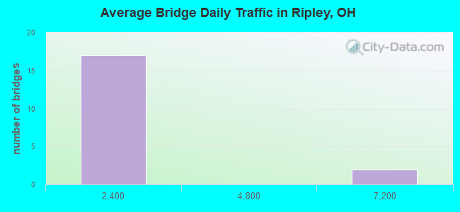
- 20,999Total average daily traffic
- 1,913Total average daily truck traffic
- 29,145Total future (year 1971) average daily traffic
- National Bridge Inventory (NBI) Registered Bridges for Ripley
- No street view available for this location
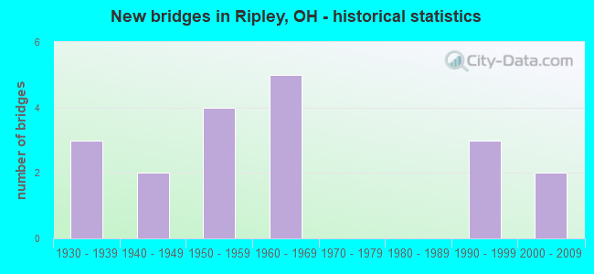
- New bridges - historical statistics
- 31930-1939
- 21940-1949
- 41950-1959
- 51960-1969
- 31990-1999
- 22000-2009

- Reconstructed bridges - Historical Statistics
- 11960-1969
- 01970-1979
- 11980-1989
- 21990-1999
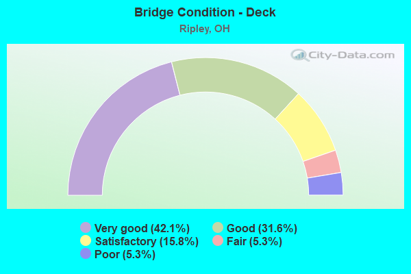
- Bridge Condition - Deck
- 42.1%Very good
- 31.6%Good
- 15.8%Satisfactory
- 5.3%Fair
- 5.3%Poor
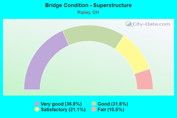
- Bridge Condition - Superstructure
- 36.8%Very good
- 31.6%Good
- 21.1%Satisfactory
- 10.5%Fair
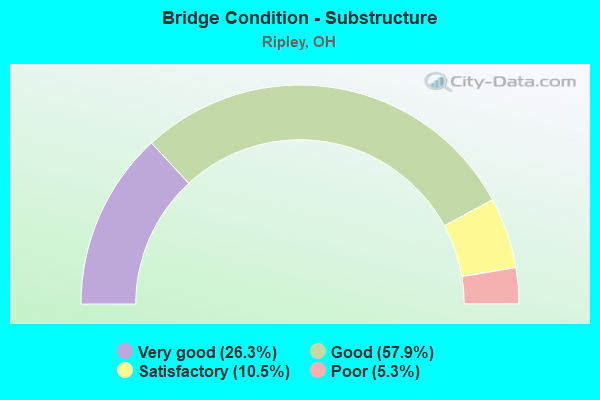
- Bridge Condition - Substructure
- 26.3%Very good
- 57.9%Good
- 10.5%Satisfactory
- 5.3%Poor
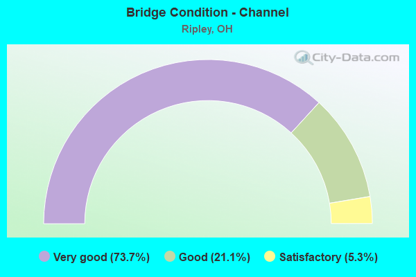
- Bridge Condition - Channel
- 73.7%Very good
- 21.1%Good
- 5.3%Satisfactory
Find on map >> Show street view
Structure Number: 801119, Location: RIPLEY (Lat: 38.743481, Lng: -83.844031), Route carried "on" structure: US 52, Year Built: 1940, Status: Open, Structure Length: 8.20m (26.90ft), Average Daily Traffic: 6,173 (year 2015), Truck Traffic: 3%, Average Future Daily Traffic: 8,568 (year 2035), Design Load: H 15, Features Intersected: RED OAK CREEK
Minimum Vertical Clearance: 30+ m (98+ ft), Kilometerpoint: 20.101, Lanes on structure: 2, Base Highway Network: Yes, Owner: State Highway Agency, Approaching Roadway Width: 11.0m (36.1ft), Skew: 2 degrees, Material/Design: Steel, Design/Construction: Girder and Floorbeam System, Number Of Spans In Main Unit: 3, Length of Maximum Span: 30.2m (99.1ft), Curb or Sidewalk Widths: Left: 1.1m (3.6ft), Right: 1.1m (3.6ft), Curb-To-Curb Width: 11.0m (36.1ft), Out-to-Out Width: 11.7m (38.4ft)
Condition: Deck: Fair, Superstructure: Fair, Substructure: Satisfactory, Channel: Good, Operating Rating: 42.1 metric tons, Method Used To Determine Operating Rating: Allowable Stress (AS) rating reported by rating factor (RF) method using MS18 loading, Inventory Rating: 32.4 metric tons, Method Used To Determine Inventory Rating: Allowable Stress (AS) rating reported by rating factor (RF) method using MS18 loading, Structural Evaluation: Somewhat better than minimum adequacy, Deck Geometry: Meets minimum limits, Waterway Adequacy: Better than present minimum criteria, Approach Roadway Alignment: Better than present minimum criteria, Length Of Structure Improvement: 8.20m (26.90ft), Designated Inspection Frequency: Every 12 months, Underwater Inspection Frequency: Every 60 months, Inspection Date: March 2021, Underwater Inspection Date: July 2019, Bridge Improvement Cost: $8,000, Roadway Improvement Cost: $1,000, Total Project Cost: $10,000, Deck Structure Type: Concrete Cast-file-Place, Wearing Surface/Protective System: Wearing Surface: Integral Concrete
Find on map >> Show street view
Structure Number: 801178, Location: .48 MI E OF RIPLEY (Lat: 38.720819, Lng: -83.826700), Route carried "on" structure: US 52, Year Built: 1956, Status: Open, Structure Length: 11.31m (37.11ft), Average Daily Traffic: 6,397 (year 2015), Truck Traffic: 14%, Average Future Daily Traffic: 8,879 (year 2035), Design Load: HS 20, Features Intersected: EAGLE CREEK
Minimum Vertical Clearance: 30+ m (98+ ft), Kilometerpoint: 23.062, Lanes on structure: 2, Base Highway Network: Yes, Owner: State Highway Agency, Approaching Roadway Width: 10.4m (34.1ft), Skew: 2 degrees, Material/Design: Steel continuous, Design/Construction: Stringer/Multi-beam, Number Of Spans In Main Unit: 5, Length of Maximum Span: 23.8m (78.1ft), Curb or Sidewalk Widths: Left: 0.3m (1.0ft), Right: 0.3m (1.0ft), Curb-To-Curb Width: 9.2m (30.2ft), Out-to-Out Width: 10.4m (34.1ft)
Condition: Deck: Satisfactory, Superstructure: Satisfactory, Substructure: Good, Channel: Very good, Operating Rating: 35.6 metric tons, Method Used To Determine Operating Rating: Load and Resistance Factor Rating (LRFR) rating reported by rating factor(RF) method using HL-93 loadings, Inventory Rating: 25.9 metric tons, Method Used To Determine Inventory Rating: Load and Resistance Factor Rating (LRFR) rating reported by rating factor(RF) method using HL-93 loadings, Structural Evaluation: Equal to present minimum criteria, Deck Geometry: Meets minimum limits, Waterway Adequacy: Equal to present desirable criteria, Approach Roadway Alignment: Equal to present desirable criteria, Designated Inspection Frequency: Every 12 months, Underwater Inspection Frequency: Every 60 months, Inspection Date: August 2021, Underwater Inspection Date: July 2019, Deck Structure Type: Concrete Cast-file-Place, Wearing Surface/Protective System: Wearing Surface: Integral Concrete
Find on map >> Show street view
Structure Number: 801356, Location: .59 MI W OF US 68 (Lat: 38.793100, Lng: -83.799731), Route carried "on" structure: US 62, Year Built: 1966, Status: Open, Structure Length: 4.45m (14.60ft), Average Daily Traffic: 1,985 (year 2015), Truck Traffic: 14%, Average Future Daily Traffic: 2,755 (year 2035), Design Load: H 20, Features Intersected: TRIB OF RED OAK CREEK
Minimum Vertical Clearance: 30+ m (98+ ft), Kilometerpoint: 17.687, Lanes on structure: 2, Base Highway Network: Yes, Owner: State Highway Agency, Approaching Roadway Width: 12.2m (40.0ft), Skew: 3 degrees, Material/Design: Steel continuous, Design/Construction: Stringer/Multi-beam, Number Of Spans In Main Unit: 3, Length of Maximum Span: 15.9m (52.2ft), Curb-To-Curb Width: 12.2m (40.0ft), Out-to-Out Width: 12.2m (40.0ft)
Condition: Deck: Good, Superstructure: Good, Substructure: Good, Channel: Very good, Operating Rating: 42.1 metric tons, Method Used To Determine Operating Rating: Allowable Stress (AS) rating reported by rating factor (RF) method using MS18 loading, Inventory Rating: 32.4 metric tons, Method Used To Determine Inventory Rating: Allowable Stress (AS) rating reported by rating factor (RF) method using MS18 loading, Structural Evaluation: Better than present minimum criteria, Deck Geometry: Better than present minimum criteria, Waterway Adequacy: Equal to present desirable criteria, Approach Roadway Alignment: Equal to present desirable criteria, Designated Inspection Frequency: Every 24 months, Inspection Date: April 2021, Deck Structure Type: Concrete Cast-file-Place, Wearing Surface/Protective System: Wearing Surface: Integral Concrete
Find on map >> Show street view
Structure Number: 80138, Location: .59 MI W OF US 68 (Lat: 38.793131, Lng: -83.799419), Route carried "on" structure: US 62, Year Built: 1966, Status: Open, Structure Length: 4.45m (14.60ft), Average Daily Traffic: 1,985 (year 2015), Truck Traffic: 14%, Average Future Daily Traffic: 2,755 (year 2035), Design Load: H 20, Features Intersected: TRIB OF RED OAK CREEK
Minimum Vertical Clearance: 30+ m (98+ ft), Kilometerpoint: 17.687, Lanes on structure: 2, Base Highway Network: Yes, Owner: State Highway Agency, Approaching Roadway Width: 12.2m (40.0ft), Skew: 3 degrees, Material/Design: Steel continuous, Design/Construction: Stringer/Multi-beam, Number Of Spans In Main Unit: 3, Length of Maximum Span: 15.9m (52.2ft), Curb-To-Curb Width: 12.2m (40.0ft), Out-to-Out Width: 12.2m (40.0ft)
Condition: Deck: Good, Superstructure: Good, Substructure: Good, Channel: Very good, Operating Rating: 42.1 metric tons, Method Used To Determine Operating Rating: Allowable Stress (AS) rating reported by rating factor (RF) method using MS18 loading, Inventory Rating: 32.4 metric tons, Method Used To Determine Inventory Rating: Allowable Stress (AS) rating reported by rating factor (RF) method using MS18 loading, Structural Evaluation: Better than present minimum criteria, Deck Geometry: Better than present minimum criteria, Waterway Adequacy: Equal to present desirable criteria, Approach Roadway Alignment: Better than present minimum criteria, Designated Inspection Frequency: Every 24 months, Inspection Date: April 2021, Deck Structure Type: Concrete Cast-file-Place, Wearing Surface/Protective System: Wearing Surface: Integral Concrete
Find on map >> Show street view
Structure Number: 830097, Location: .87 MI. N. OF JCT. US 52 (Lat: 38.765800, Lng: -83.851561), Route carried "on" structure: County highway C0030, Year Built: 1956, Year Reconstructed: 1999, Status: Open, Structure Length: 0.82m (2.69ft), Average Daily Traffic: 379 (year 2015), Truck Traffic: 8%, Average Future Daily Traffic: 526 (year 2035), Design Load: HS 20+Mod, Features Intersected: CORNICK RUN, Facility Carried by Structure: OLD 68
Minimum Vertical Clearance: 30+ m (98+ ft), Kilometerpoint: 1.400, Lanes on structure: 2, Owner: County Highway Agency, Approaching Roadway Width: 6.1m (20.0ft), Skew: 3 degrees, Material/Design: Concrete, Design/Construction: Box Beam or Girders - Multiple, Number Of Spans In Main Unit: 1, Length of Maximum Span: 7.6m (24.9ft), Curb-To-Curb Width: 7.3m (24.0ft), Out-to-Out Width: 7.3m (24.0ft)
Condition: Deck: Very good, Superstructure: Very good, Substructure: Good, Channel: Satisfactory, Operating Rating: 51.8 metric tons, Method Used To Determine Operating Rating: Load Factor (LF) rating reported by rating factor (RF) method using MS18 loading, Inventory Rating: 29.2 metric tons, Method Used To Determine Inventory Rating: Load Factor (LF) rating reported by rating factor (RF) method using MS18 loading, Structural Evaluation: Better than present minimum criteria, Deck Geometry: Somewhat better than minimum adequacy, Waterway Adequacy: Equal to present desirable criteria, Approach Roadway Alignment: Meets minimum limits, Length Of Structure Improvement: 3.05m (10.01ft), Designated Inspection Frequency: Every 24 months, Inspection Date: November 2021, Roadway Improvement Cost: $5,000, Total Project Cost: $60,000, Deck Structure Type: Concrete Cast-file-Place, Wearing Surface/Protective System: Wearing Surface: Bituminous, Deck Protection: Bituminous
Find on map >> Show street view
Structure Number: 830585, Location: .45 MI. E. OF JCT. US 68 (Lat: 38.771300, Lng: -83.806550), Route carried "on" structure: County highway C0019, Year Built: 1950, Status: Open, Structure Length: 1.10m (3.61ft), Average Daily Traffic: 385 (year 2015), Truck Traffic: 8%, Average Future Daily Traffic: 534 (year 2035), Design Load: H 10, Features Intersected: CHICKEN HOLLOW, Facility Carried by Structure: CHICKEN HOLLOW RD
Minimum Vertical Clearance: 30+ m (98+ ft), Kilometerpoint: 0.982, Lanes on structure: 2, Owner: County Highway Agency, Approaching Roadway Width: 6.1m (20.0ft), Skew: 4 degrees, Material/Design: Steel, Design/Construction: Stringer/Multi-beam, Number Of Spans In Main Unit: 1, Length of Maximum Span: 8.5m (27.9ft), Curb-To-Curb Width: 7.3m (24.0ft), Out-to-Out Width: 7.5m (24.6ft)
Condition: Deck: Satisfactory, Superstructure: Satisfactory, Substructure: Good, Channel: Good, Operating Rating: 25.9 metric tons, Method Used To Determine Operating Rating: Allowable Stress (AS) rating reported by rating factor (RF) method using MS18 loading, Inventory Rating: 19.4 metric tons, Method Used To Determine Inventory Rating: Allowable Stress (AS) rating reported by rating factor (RF) method using MS18 loading, Structural Evaluation: Somewhat better than minimum adequacy, Deck Geometry: Somewhat better than minimum adequacy, Waterway Adequacy: Equal to present minimum criteria, Approach Roadway Alignment: Meets minimum limits, Designated Inspection Frequency: Every 12 months, Inspection Date: October 2021, Deck Structure Type: Concrete Cast-file-Place, Wearing Surface/Protective System: Wearing Surface: Bituminous
Find on map >> Show street view
Structure Number: 830593, Location: .57 MI. E. OF JCT. US 68 (Lat: 38.771550, Lng: -83.804381), Route carried "on" structure: County highway C0019, Year Built: 1960, Status: Open, Structure Length: 0.98m (3.22ft), Average Daily Traffic: 385 (year 2015), Truck Traffic: 8%, Average Future Daily Traffic: 534 (year 2035), Design Load: H 10, Features Intersected: CHICKEN HOLLOW, Facility Carried by Structure: CHICKEN HOLLOW RD
Minimum Vertical Clearance: 30+ m (98+ ft), Kilometerpoint: 1.175, Lanes on structure: 2, Owner: County Highway Agency, Approaching Roadway Width: 7.6m (24.9ft), Skew: 4 degrees, Material/Design: Steel, Design/Construction: Stringer/Multi-beam, Number Of Spans In Main Unit: 1, Length of Maximum Span: 8.5m (27.9ft), Curb-To-Curb Width: 7.3m (24.0ft), Out-to-Out Width: 7.6m (24.9ft)
Condition: Deck: Satisfactory, Superstructure: Satisfactory, Substructure: Good, Channel: Very good, Operating Rating: 25.9 metric tons, Method Used To Determine Operating Rating: Allowable Stress (AS) rating reported by rating factor (RF) method using MS18 loading, Inventory Rating: 19.4 metric tons, Method Used To Determine Inventory Rating: Allowable Stress (AS) rating reported by rating factor (RF) method using MS18 loading, Structural Evaluation: Somewhat better than minimum adequacy, Deck Geometry: Somewhat better than minimum adequacy, Waterway Adequacy: Equal to present desirable criteria, Approach Roadway Alignment: Meets minimum limits, Designated Inspection Frequency: Every 12 months, Inspection Date: October 2021, Deck Structure Type: Concrete Cast-file-Place, Wearing Surface/Protective System: Wearing Surface: Bituminous
Find on map >> Show street view
Structure Number: 831042, Location: .27 MI. W. OF JCT. C13 (Lat: 38.746989, Lng: -83.781339), Route carried "on" structure: County highway T0028, Year Built: 1964, Status: Posted for load, Structure Length: 1.40m (4.59ft), Average Daily Traffic: 100 (year 1951), Average Future Daily Traffic: 139 (year 1971), Design Load: HS 20+Mod, Features Intersected: FOX HOLLOW, Facility Carried by Structure: EAGLE CREEK ROAD
Minimum Vertical Clearance: 30+ m (98+ ft), Kilometerpoint: 3.782, Lanes on structure: 1, Owner: County Highway Agency, Approaching Roadway Width: 4.3m (14.1ft), Skew: 3 degrees, Material/Design: Steel, Design/Construction: Stringer/Multi-beam, Number Of Spans In Main Unit: 1, Length of Maximum Span: 12.5m (41.0ft), Curb-To-Curb Width: 4.9m (16.1ft), Out-to-Out Width: 5.1m (16.7ft)
Condition: Deck: Good, Superstructure: Very good, Substructure: Good, Channel: Very good, Operating Rating: 22.7 metric tons, Method Used To Determine Operating Rating: Load Factor (LF) rating reported by rating factor (RF) method using MS18 loading, Inventory Rating: 13.0 metric tons, Method Used To Determine Inventory Rating: Load Factor (LF) rating reported by rating factor (RF) method using MS18 loading, Structural Evaluation: Meets minimum limits, Deck Geometry: High priority of corrective action, Waterway Adequacy: Equal to present minimum criteria, Approach Roadway Alignment: Meets minimum limits, Bridge Posting: Required (Relationship of Operating Rating to Maximum Legal Load: 30.0 - 39.9% below), Designated Inspection Frequency: Every 12 months, Inspection Date: October 2021, Deck Structure Type: Concrete Cast-file-Place, Wearing Surface/Protective System: Wearing Surface: Bituminous
Find on map >> Show street view
Structure Number: 832308, Location: .54 MI. E. OF JCT. US62 (Lat: 38.794831, Lng: -83.789461), Route carried "on" structure: County highway T0231, Year Built: 1958, Status: Posted for load, Structure Length: 1.10m (3.61ft), Average Daily Traffic: 324 (year 2015), Truck Traffic: 7%, Average Future Daily Traffic: 450 (year 2035), Design Load: HS 15, Features Intersected: STREAM, Facility Carried by Structure: HARTMAN ROAD
Minimum Vertical Clearance: 30+ m (98+ ft), Kilometerpoint: 4.651, Lanes on structure: 2, Owner: County Highway Agency, Approaching Roadway Width: 5.8m (19.0ft), Skew: 3 degrees, Material/Design: Steel, Design/Construction: Stringer/Multi-beam, Number Of Spans In Main Unit: 1, Length of Maximum Span: 9.1m (29.9ft), Curb-To-Curb Width: 6.1m (20.0ft), Out-to-Out Width: 6.2m (20.3ft)
Condition: Deck: Good, Superstructure: Good, Substructure: Good, Channel: Good, Operating Rating: 25.9 metric tons, Method Used To Determine Operating Rating: Load Factor (LF) rating reported by rating factor (RF) method using MS18 loading, Inventory Rating: 16.2 metric tons, Method Used To Determine Inventory Rating: Load Factor (LF) rating reported by rating factor (RF) method using MS18 loading, Structural Evaluation: Somewhat better than minimum adequacy, Deck Geometry: Meets minimum limits, Waterway Adequacy: Better than present minimum criteria, Approach Roadway Alignment: Better than present minimum criteria, Bridge Posting: Required (Relationship of Operating Rating to Maximum Legal Load: > 39.9% below), Designated Inspection Frequency: Every 12 months, Inspection Date: October 2021, Deck Structure Type: Concrete Cast-file-Place, Wearing Surface/Protective System: Wearing Surface: Bituminous
Find on map >> Show street view
Structure Number: 833053, Location: .08 MI. E. OF JCT C62 (Lat: 38.754261, Lng: -83.827350), Route carried "on" structure: County highway C0013, Year Built: 1945, Year Reconstructed: 1965, Status: Open, Structure Length: 1.95m (6.40ft), Average Daily Traffic: 104 (year 2015), Truck Traffic: 8%, Average Future Daily Traffic: 144 (year 2035), Design Load: H 20, Features Intersected: RED OAK CREEK, Facility Carried by Structure: KLINKER RD
Minimum Vertical Clearance: 30+ m (98+ ft), Kilometerpoint: 0.129, Lanes on structure: 1, Owner: County Highway Agency, Approaching Roadway Width: 4.9m (16.1ft), Material/Design: Steel, Design/Construction: Truss - Thru, Number Of Spans In Main Unit: 1, Length of Maximum Span: 18.6m (61.0ft), Curb-To-Curb Width: 4.9m (16.1ft), Out-to-Out Width: 4.9m (16.1ft)
Condition: Deck: Good, Superstructure: Good, Substructure: Good, Channel: Very good, Operating Rating: 38.9 metric tons, Method Used To Determine Operating Rating: Load Factor (LF) rating reported by rating factor (RF) method using MS18 loading, Inventory Rating: 22.7 metric tons, Method Used To Determine Inventory Rating: Load Factor (LF) rating reported by rating factor (RF) method using MS18 loading, Structural Evaluation: Equal to present minimum criteria, Deck Geometry: High priority of replacement, Waterway Adequacy: Better than present minimum criteria, Approach Roadway Alignment: Somewhat better than minimum adequacy, Designated Inspection Frequency: Every 12 months, Critical Feature Inspection Frequency: Every 24 months, Inspection Date: August 2021, Critical Feature Inspection Date: August 2020, Deck Structure Type: Concrete Cast-file-Place, Wearing Surface/Protective System: Wearing Surface: Bituminous
Find on map >> Show street view
Structure Number: 833096, Location: .1 MI. W. OF JCT. T28 (Lat: 38.749661, Lng: -83.780781), Route carried "on" structure: County highway C0013, Year Built: 1968, Status: Open, Structure Length: 1.19m (3.90ft), Average Daily Traffic: 104 (year 2015), Truck Traffic: 8%, Average Future Daily Traffic: 144 (year 2035), Design Load: H 20, Features Intersected: FOX HOLLOW RUN, Facility Carried by Structure: NORTHPOLE RD
Minimum Vertical Clearance: 30+ m (98+ ft), Kilometerpoint: 4.474, Lanes on structure: 2, Owner: County Highway Agency, Approaching Roadway Width: 5.8m (19.0ft), Skew: 2 degrees, Material/Design: Prestressed concrete, Design/Construction: Box Beam or Girders - Multiple, Number Of Spans In Main Unit: 1, Length of Maximum Span: 11.6m (38.1ft), Curb-To-Curb Width: 6.5m (21.3ft), Out-to-Out Width: 6.5m (21.3ft)
Condition: Deck: Good, Superstructure: Good, Substructure: Very good, Channel: Very good, Operating Rating: 81.0 metric tons, Method Used To Determine Operating Rating: Load Factor (LF) rating reported by rating factor (RF) method using MS18 loading, Inventory Rating: 77.8 metric tons, Method Used To Determine Inventory Rating: Load Factor (LF) rating reported by rating factor (RF) method using MS18 loading, Structural Evaluation: Better than present minimum criteria, Deck Geometry: Meets minimum limits, Waterway Adequacy: Somewhat better than minimum adequacy, Approach Roadway Alignment: Equal to present minimum criteria, Designated Inspection Frequency: Every 24 months, Inspection Date: October 2021, Deck Structure Type: Concrete Cast-file-Place, Wearing Surface/Protective System: Wearing Surface: Bituminous
Find on map >> Show street view
Structure Number: 833568, Location: 50 FEET S. OF JCT. T263 (Lat: 38.762450, Lng: -83.824511), Route carried "on" structure: County highway C0062, Year Built: 1931, Year Reconstructed: 1989, Status: Open, Structure Length: 0.64m (2.10ft), Average Daily Traffic: 268 (year 2015), Truck Traffic: 5%, Average Future Daily Traffic: 372 (year 2035), Design Load: HS 20, Features Intersected: STREAM, Facility Carried by Structure: RIPLEY RD
Minimum Vertical Clearance: 30+ m (98+ ft), Kilometerpoint: 1.416, Lanes on structure: 2, Owner: County Highway Agency, Approaching Roadway Width: 7.6m (24.9ft), Material/Design: Concrete, Design/Construction: Box Beam or Girders - Multiple, Number Of Spans In Main Unit: 1, Length of Maximum Span: 6.4m (21.0ft), Curb-To-Curb Width: 9.1m (29.9ft), Out-to-Out Width: 9.1m (29.9ft)
Condition: Deck: Very good, Superstructure: Very good, Substructure: Good, Channel: Very good, Operating Rating: 42.1 metric tons, Method Used To Determine Operating Rating: Load Factor (LF) rating reported by rating factor (RF) method using MS18 loading, Inventory Rating: 25.9 metric tons, Method Used To Determine Inventory Rating: Load Factor (LF) rating reported by rating factor (RF) method using MS18 loading, Structural Evaluation: Equal to present minimum criteria, Deck Geometry: Equal to present minimum criteria, Waterway Adequacy: Equal to present desirable criteria, Approach Roadway Alignment: Better than present minimum criteria, Designated Inspection Frequency: Every 24 months, Inspection Date: November 2021, Deck Structure Type: Concrete Cast-file-Place, Wearing Surface/Protective System: Wearing Surface: Integral Concrete
Find on map >> Show street view
Structure Number: 833576, Location: 1.43 MI.N.OF RIPLEY CORP. (Lat: 38.765081, Lng: -83.815431), Route carried "on" structure: County highway C0062, Year Built: 1930, Year Reconstructed: 1995, Status: Open, Structure Length: 3.41m (11.19ft), Average Daily Traffic: 268 (year 2015), Truck Traffic: 7%, Average Future Daily Traffic: 372 (year 2035), Design Load: HS 20+Mod, Features Intersected: RED OAK CREEK, Facility Carried by Structure: RIPLEY RD
Minimum Vertical Clearance: 30+ m (98+ ft), Kilometerpoint: 2.301, Lanes on structure: 2, Owner: County Highway Agency, Approaching Roadway Width: 10.1m (33.1ft), Skew: 4 degrees, Material/Design: Prestressed concrete, Design/Construction: Box Beam or Girders - Multiple, Number Of Spans In Main Unit: 2, Length of Maximum Span: 16.8m (55.1ft), Curb-To-Curb Width: 9.9m (32.5ft), Out-to-Out Width: 9.9m (32.5ft)
Condition: Deck: Very good, Superstructure: Satisfactory, Substructure: Satisfactory, Channel: Good, Operating Rating: 42.1 metric tons, Method Used To Determine Operating Rating: Allowable Stress (AS) rating reported by rating factor (RF) method using MS18 loading, Inventory Rating: 32.4 metric tons, Method Used To Determine Inventory Rating: Allowable Stress (AS) rating reported by rating factor (RF) method using MS18 loading, Structural Evaluation: Equal to present minimum criteria, Deck Geometry: Better than present minimum criteria, Waterway Adequacy: Superior to present desirable criteria, Approach Roadway Alignment: Equal to present desirable criteria, Designated Inspection Frequency: Every 12 months, Inspection Date: November 2021, Deck Structure Type: Concrete Cast-file-Place, Wearing Surface/Protective System: Wearing Surface: Bituminous, Deck Protection: Bituminous
Find on map >> Show street view
Structure Number: 834238, Location: .15 MI.W. OF RIPLEY CORP. (Lat: 38.727139, Lng: -83.830019), Route carried "on" structure: County highway C1007, Year Built: 1930, Status: Open, Structure Length: 0.64m (2.10ft), Average Daily Traffic: 951 (year 2015), Truck Traffic: 5%, Average Future Daily Traffic: 1,320 (year 2035), Design Load: HS 15, Features Intersected: STREAM, Facility Carried by Structure: STEPHENSON ROAD
Minimum Vertical Clearance: 30+ m (98+ ft), Kilometerpoint: 0.515, Lanes on structure: 2, Owner: County Highway Agency, Approaching Roadway Width: 8.2m (26.9ft), Material/Design: Concrete, Design/Construction: Slab, Number Of Spans In Main Unit: 1, Length of Maximum Span: 6.4m (21.0ft), Curb-To-Curb Width: 7.6m (24.9ft), Out-to-Out Width: 8.3m (27.2ft)
Condition: Deck: Poor, Superstructure: Fair, Substructure: Poor, Channel: Very good, Operating Rating: 55.1 metric tons, Method Used To Determine Operating Rating: Load Factor (LF) rating reported by rating factor (RF) method using MS18 loading, Inventory Rating: 32.4 metric tons, Method Used To Determine Inventory Rating: Load Factor (LF) rating reported by rating factor (RF) method using MS18 loading, Structural Evaluation: Meets minimum limits, Deck Geometry: Meets minimum limits, Waterway Adequacy: Equal to present desirable criteria, Approach Roadway Alignment: Equal to present minimum criteria, Designated Inspection Frequency: Every 12 months, Inspection Date: October 2021, Deck Structure Type: Concrete Cast-file-Place, Wearing Surface/Protective System: Wearing Surface: Bituminous
Find on map >> Show street view
Structure Number: 834637, Location: 2.83 MI E US 52 (Lat: 38.726711, Lng: -83.786769), Route carried "on" structure: County highway C049A, Year Built: 1990, Status: Open, Structure Length: 6.52m (21.39ft), Average Daily Traffic: 348 (year 2015), Truck Traffic: 7%, Average Future Daily Traffic: 483 (year 2035), Design Load: HS 20, Features Intersected: EAGLE CREEK, Facility Carried by Structure: SCOFFIELD RD
Minimum Vertical Clearance: 30+ m (98+ ft), Kilometerpoint: 4.554, Lanes on structure: 2, Owner: County Highway Agency, Approaching Roadway Width: 8.5m (27.9ft), Skew: 2 degrees, Material/Design: Prestressed concrete, Design/Construction: Box Beam or Girders - Multiple, Number Of Spans In Main Unit: 3, Length of Maximum Span: 21.9m (71.9ft), Curb-To-Curb Width: 8.5m (27.9ft), Out-to-Out Width: 8.5m (27.9ft)
Condition: Deck: Very good, Superstructure: Good, Substructure: Very good, Channel: Very good, Operating Rating: 42.1 metric tons, Method Used To Determine Operating Rating: Allowable Stress (AS) rating reported by rating factor (RF) method using MS18 loading, Inventory Rating: 32.4 metric tons, Method Used To Determine Inventory Rating: Allowable Stress (AS) rating reported by rating factor (RF) method using MS18 loading, Structural Evaluation: Better than present minimum criteria, Deck Geometry: Equal to present minimum criteria, Waterway Adequacy: Superior to present desirable criteria, Approach Roadway Alignment: Equal to present desirable criteria, Designated Inspection Frequency: Every 24 months, Inspection Date: October 2021, Deck Structure Type: Concrete Cast-file-Place, Wearing Surface/Protective System: Wearing Surface: Bituminous, Membrane: Built-up, Deck Protection: Epoxy Coated Reinforcing
Find on map >> Show street view
Structure Number: 83492, Location: 0.62 MI N RIPLEY CORP (Lat: 38.759819, Lng: -83.827950), Route carried "on" structure: County highway C0062, Year Built: 1994, Status: Open, Structure Length: 2.74m (8.99ft), Average Daily Traffic: 268 (year 2015), Truck Traffic: 5%, Average Future Daily Traffic: 372 (year 2035), Design Load: HS 20+Mod, Features Intersected: RED OAK CREEK, Facility Carried by Structure: RIPLEY RD
Minimum Vertical Clearance: 30+ m (98+ ft), Kilometerpoint: 0.998, Lanes on structure: 2, Owner: County Highway Agency, Approaching Roadway Width: 6.1m (20.0ft), Skew: 3 degrees, Material/Design: Prestressed concrete, Design/Construction: Box Beam or Girders - Multiple, Number Of Spans In Main Unit: 1, Length of Maximum Span: 26.8m (87.9ft), Curb-To-Curb Width: 8.3m (27.2ft), Out-to-Out Width: 8.3m (27.2ft)
Condition: Deck: Very good, Superstructure: Very good, Substructure: Good, Channel: Very good, Operating Rating: 42.1 metric tons, Method Used To Determine Operating Rating: Allowable Stress (AS) rating reported by rating factor (RF) method using MS18 loading, Inventory Rating: 32.4 metric tons, Method Used To Determine Inventory Rating: Allowable Stress (AS) rating reported by rating factor (RF) method using MS18 loading, Structural Evaluation: Better than present minimum criteria, Deck Geometry: Somewhat better than minimum adequacy, Waterway Adequacy: Equal to present desirable criteria, Approach Roadway Alignment: Equal to present desirable criteria, Designated Inspection Frequency: Every 24 months, Inspection Date: November 2021, Deck Structure Type: Concrete Cast-file-Place, Wearing Surface/Protective System: Wearing Surface: Bituminous
Find on map >> Show street view
Structure Number: 83508, Location: 0.22 MI. S. OF BEALER RD. (Lat: 38.793019, Lng: -83.801189), Route carried "on" structure: County highway T0008, Year Built: 1998, Status: Open, Structure Length: 0.91m (2.99ft), Average Daily Traffic: 96 (year 2015), Truck Traffic: 7%, Average Future Daily Traffic: 133 (year 2035), Design Load: HS 20+Mod, Features Intersected: RED OAK CREEK, Facility Carried by Structure: CLUXTON SOUTH
Minimum Vertical Clearance: 30+ m (98+ ft), Kilometerpoint: 0.354, Lanes on structure: 2, Owner: County Highway Agency, Approaching Roadway Width: 7.3m (24.0ft), Material/Design: Concrete, Design/Construction: Box Beam or Girders - Multiple, Number Of Spans In Main Unit: 1, Length of Maximum Span: 8.5m (27.9ft), Curb-To-Curb Width: 7.3m (24.0ft), Out-to-Out Width: 7.3m (24.0ft)
Condition: Deck: Very good, Superstructure: Very good, Substructure: Very good, Channel: Very good, Operating Rating: 42.1 metric tons, Method Used To Determine Operating Rating: Load Factor (LF) rating reported by rating factor (RF) method using MS18 loading, Inventory Rating: 25.9 metric tons, Method Used To Determine Inventory Rating: Load Factor (LF) rating reported by rating factor (RF) method using MS18 loading, Structural Evaluation: Equal to present minimum criteria, Deck Geometry: Equal to present minimum criteria, Waterway Adequacy: Superior to present desirable criteria, Approach Roadway Alignment: Superior to present desirable criteria, Designated Inspection Frequency: Every 24 months, Inspection Date: October 2021, Deck Structure Type: Concrete Cast-file-Place, Wearing Surface/Protective System: Wearing Surface: Bituminous, Deck Protection: Bituminous
Find on map >> Show street view
Structure Number: 835366, Location: 1.01 M. N. OF US 52 (Lat: 38.767419, Lng: -83.850389), Route carried "on" structure: County highway C0030, Year Built: 2004, Status: Open, Structure Length: 0.91m (2.99ft), Average Daily Traffic: 379 (year 2015), Truck Traffic: 8%, Average Future Daily Traffic: 526 (year 2035), Design Load: HS 20+Mod, Features Intersected: CREEK, Facility Carried by Structure: OLD 68
Minimum Vertical Clearance: 30+ m (98+ ft), Kilometerpoint: 1.625, Lanes on structure: 2, Owner: County Highway Agency, Approaching Roadway Width: 6.1m (20.0ft), Skew: 2 degrees, Material/Design: Concrete, Design/Construction: Box Beam or Girders - Multiple, Number Of Spans In Main Unit: 1, Length of Maximum Span: 8.8m (28.9ft), Curb-To-Curb Width: 8.2m (26.9ft), Out-to-Out Width: 8.2m (26.9ft)
Condition: Deck: Very good, Superstructure: Very good, Substructure: Very good, Channel: Very good, Operating Rating: 42.1 metric tons, Method Used To Determine Operating Rating: Load Factor (LF) rating reported by rating factor (RF) method using MS18 loading, Inventory Rating: 32.4 metric tons, Method Used To Determine Inventory Rating: Load Factor (LF) rating reported by rating factor (RF) method using MS18 loading, Structural Evaluation: Equal to present desirable criteria, Deck Geometry: Somewhat better than minimum adequacy, Waterway Adequacy: Equal to present desirable criteria, Approach Roadway Alignment: Equal to present desirable criteria, Designated Inspection Frequency: Every 24 months, Inspection Date: November 2021, Deck Structure Type: Concrete Cast-file-Place, Wearing Surface/Protective System: Wearing Surface: Bituminous, Deck Protection: Other
Find on map >> Show street view
Structure Number: 835544, Location: 500 FT. EAST OF US68 (Lat: 38.794431, Lng: -83.795619), Route carried "on" structure: County highway T0231, Year Built: 2007, Status: Open, Structure Length: 0.91m (2.99ft), Average Daily Traffic: 100 (year 2008), Average Future Daily Traffic: 139 (year 2028), Design Load: HS 20+Mod, Features Intersected: REDOAK CREEK, Facility Carried by Structure: HARTMAN RD.
Minimum Vertical Clearance: 30+ m (98+ ft), Kilometerpoint: 4.088, Lanes on structure: 2, Owner: County Highway Agency, Approaching Roadway Width: 4.9m (16.1ft), Skew: 2 degrees, Material/Design: Concrete, Design/Construction: Box Beam or Girders - Multiple, Number Of Spans In Main Unit: 1, Length of Maximum Span: 8.8m (28.9ft), Curb-To-Curb Width: 6.1m (20.0ft), Out-to-Out Width: 8.2m (26.9ft)
Condition: Deck: Very good, Superstructure: Very good, Substructure: Very good, Channel: Very good, Operating Rating: 42.1 metric tons, Method Used To Determine Operating Rating: Load Factor (LF) rating reported by rating factor (RF) method using MS18 loading, Inventory Rating: 32.4 metric tons, Method Used To Determine Inventory Rating: Load Factor (LF) rating reported by rating factor (RF) method using MS18 loading, Structural Evaluation: Equal to present desirable criteria, Deck Geometry: Somewhat better than minimum adequacy, Waterway Adequacy: Equal to present desirable criteria, Approach Roadway Alignment: Equal to present desirable criteria, Designated Inspection Frequency: Every 24 months, Inspection Date: October 2021, Deck Structure Type: Concrete Cast-file-Place, Wearing Surface/Protective System: Wearing Surface: Bituminous, Deck Protection: Other