Bridge Statistics for Riverside, Pennsylvania (PA)
Condition, Traffic, Stress, Structural Evaluation, Project Costs
- National Bridge Inventory (NBI) Statistics
- 19Number of bridges
- 131ft / 40.4mTotal length
- $585,000Total costs
- 70,090Total average daily traffic
- 25,320Total average daily truck traffic
- National Bridge Inventory (NBI) Registered Bridges for Riverside
- No street view available for this location
- New bridges - historical statistics
- 11910-1919
- 21930-1939
- 21940-1949
- 11950-1959
- 91960-1969
- 11970-1979
- 31980-1989
- Reconstructed bridges - Historical Statistics
- 31980-1989
- 21990-1999
- 22000-2009
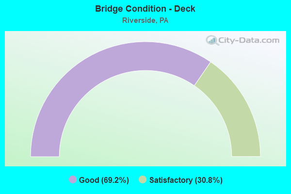
- Bridge Condition - Deck
- 69.2%Good
- 30.8%Satisfactory
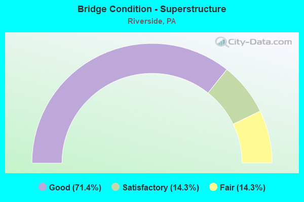
- Bridge Condition - Superstructure
- 71.4%Good
- 14.3%Satisfactory
- 14.3%Fair
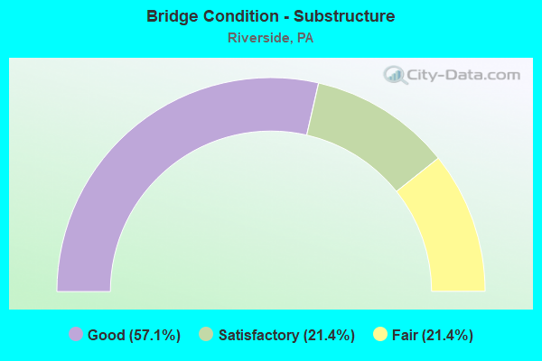
- Bridge Condition - Substructure
- 57.1%Good
- 21.4%Satisfactory
- 21.4%Fair
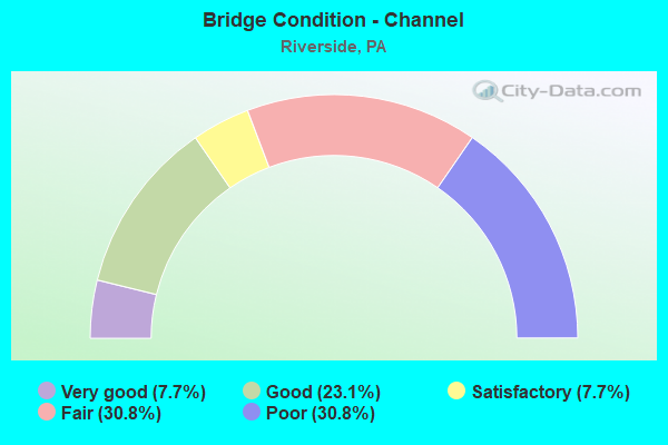
- Bridge Condition - Channel
- 7.7%Very good
- 23.1%Good
- 7.7%Satisfactory
- 30.8%Fair
- 30.8%Poor
Find on map >> Show street view
Structure Number: 2927, Location: NEAR CLARK BUILDING (Lat: 40.466667, Lng: -80.016667), Route carried "on" structure: Ramp State highway , Year Built: 1986, Status: Open, Structure Length: 14.81m (48.59ft), Average Daily Traffic: 2,278 (year 2021), Truck Traffic: 7%, Average Future Daily Traffic: 9,145 (year 2032), Design Load: HS 20, Features Intersected: PARKING AREA, Facility Carried by Structure: RAMP B from 279 SB
Minimum Vertical Clearance: 30+ m (98+ ft), Kilometerpoint: 0.000, Lanes on structure: 1, Base Highway Network: Yes, Owner: State Highway Agency, Approaching Roadway Width: 9.4m (30.8ft), Material/Design: Prestressed concrete continuous, Design/Construction: Stringer/Multi-beam, Number Of Spans In Main Unit: 5, Length of Maximum Span: 29.9m (98.1ft), Curb or Sidewalk Widths: Left: 0.2m (0.7ft), Right: 0.2m (0.7ft), Curb-To-Curb Width: 9.4m (30.8ft), Out-to-Out Width: 10.5m (34.4ft)
Condition: Deck: Satisfactory, Superstructure: Good, Substructure: Satisfactory, Operating Rating: 81.6 metric tons, Method Used To Determine Operating Rating: Load Factor (LF), Inventory Rating: 34.5 metric tons, Method Used To Determine Inventory Rating: Load Factor (LF), Structural Evaluation: Equal to present minimum criteria, Deck Geometry: Superior to present desirable criteria, Approach Roadway Alignment: Equal to present desirable criteria, Length Of Structure Improvement: 15.70m (51.51ft), Designated Inspection Frequency: Every 24 months, Inspection Date: January 2021, Deck Structure Type: Concrete Cast-file-Place, Wearing Surface/Protective System: Wearing Surface: Monolithic Concrete, Deck Protection: Epoxy Coated Reinforcing
Find on map >> Show street view
Structure Number: 28345, Location: 2.1 MI. W DANVILLE EXIT (Lat: 40.989103, Lng: -76.683011), Route carried "on" structure: Interstate 80, Year Built: 1963, Year Reconstructed: 1988, Status: Open, Structure Length: 4.15m (13.62ft), Average Daily Traffic: 14,966 (year 2021), Truck Traffic: 44%, Average Future Daily Traffic: 19,254 (year 2032), Design Load: HS 20+Mod, Features Intersected: TRIB MAUSES CR & SR 3007
Minimum Vertical Clearance: 30+ m (98+ ft), Kilometerpoint: 8.229, Lanes on structure: 2, Lanes under structure: 2, Base Highway Network: Yes, Owner: State Highway Agency, Approaching Roadway Width: 13.4m (44.0ft), Skew: 10 degrees, Material/Design: Prestressed concrete, Design/Construction: Box Beam or Girders - Single/Spread, Number Of Spans In Main Unit: 2, Length of Maximum Span: 19.8m (65.0ft), Curb or Sidewalk Widths: Left: 0.2m (0.7ft), Right: 0.2m (0.7ft), Curb-To-Curb Width: 13.0m (42.7ft), Out-to-Out Width: 13.9m (45.6ft)
Condition: Deck: Satisfactory, Superstructure: Fair, Substructure: Good, Channel: Good, Inventory Rating: 29.0 metric tons, Method Used To Determine Inventory Rating: Load Factor (LF), Structural Evaluation: Somewhat better than minimum adequacy, Deck Geometry: Superior to present desirable criteria, Underclear: Somewhat better than minimum adequacy, Waterway Adequacy: Superior to present desirable criteria, Approach Roadway Alignment: Equal to present desirable criteria, Length Of Structure Improvement: 5.00m (16.40ft), Designated Inspection Frequency: Every 24 months, Inspection Date: May 2020, Deck Structure Type: Concrete Cast-file-Place, Wearing Surface/Protective System: Wearing Surface: Monolithic Concrete
Find on map >> Show street view
Structure Number: 28346, Location: 2.1 MI. W DANVILLE EXIT (Lat: 40.989472, Lng: -76.683394), Route carried "on" structure: Interstate 80, Year Built: 1963, Year Reconstructed: 1993, Status: Open, Structure Length: 4.15m (13.62ft), Average Daily Traffic: 15,726 (year 2021), Truck Traffic: 37%, Average Future Daily Traffic: 19,130 (year 2032), Design Load: HS 20+Mod, Features Intersected: MAUSES CR-AND SR 3007
Minimum Vertical Clearance: 30+ m (98+ ft), Kilometerpoint: 8.156, Lanes on structure: 2, Lanes under structure: 2, Base Highway Network: Yes, Owner: State Highway Agency, Approaching Roadway Width: 11.6m (38.1ft), Skew: 10 degrees, Material/Design: Prestressed concrete continuous, Design/Construction: Box Beam or Girders - Single/Spread, Number Of Spans In Main Unit: 2, Length of Maximum Span: 19.8m (65.0ft), Curb or Sidewalk Widths: Left: 0.2m (0.7ft), Right: 0.2m (0.7ft), Curb-To-Curb Width: 12.9m (42.3ft), Out-to-Out Width: 13.9m (45.6ft)
Condition: Deck: Good, Superstructure: Good, Substructure: Satisfactory, Channel: Very good, Operating Rating: 92.5 metric tons, Method Used To Determine Operating Rating: Load Factor (LF), Inventory Rating: 49.0 metric tons, Method Used To Determine Inventory Rating: Load Factor (LF), Structural Evaluation: Equal to present minimum criteria, Deck Geometry: Superior to present desirable criteria, Underclear: Equal to present minimum criteria, Waterway Adequacy: Superior to present desirable criteria, Approach Roadway Alignment: Equal to present desirable criteria, Length Of Structure Improvement: 4.10m (13.45ft), Designated Inspection Frequency: Every 48 months, Inspection Date: May 2020, Deck Structure Type: Concrete Cast-file-Place, Wearing Surface/Protective System: Wearing Surface: Epoxy Overlay, Deck Protection: Epoxy Coated Reinforcing
Find on map >> Show street view
Structure Number: 28418, Location: 2.8 MI W OF DANVILLE EXIT (Lat: 40.986978, Lng: -76.706692), Route carried "on" structure: State highway , Year Built: 1962, Year Reconstructed: 1999, Status: Open, Structure Length: 7.86m (25.79ft), Average Daily Traffic: 203 (year 2022), Truck Traffic: 6%, Average Future Daily Traffic: 253 (year 2032), Design Load: H 20, Features Intersected: SR 3006 OVER I-80 EB,WB, Facility Carried by Structure: SR 3006
Minimum Vertical Clearance: 30+ m (98+ ft), Kilometerpoint: 3.750, Lanes on structure: 2, Lanes under structure: 8, Owner: State Highway Agency, Approaching Roadway Width: 5.2m (17.1ft), Material/Design: Steel continuous, Design/Construction: Stringer/Multi-beam, Number Of Spans In Main Unit: 5, Length of Maximum Span: 17.7m (58.1ft), Curb or Sidewalk Widths: Left: 0.5m (1.6ft), Right: 0.5m (1.6ft), Curb-To-Curb Width: 9.8m (32.2ft), Out-to-Out Width: 11.4m (37.4ft)
Condition: Deck: Satisfactory, Superstructure: Good, Substructure: Good, Operating Rating: 58.1 metric tons, Method Used To Determine Operating Rating: Load Factor (LF), Inventory Rating: 34.5 metric tons, Method Used To Determine Inventory Rating: Load Factor (LF), Structural Evaluation: Better than present minimum criteria, Deck Geometry: Better than present minimum criteria, Underclear: Better than present minimum criteria, Approach Roadway Alignment: Equal to present desirable criteria, Length Of Structure Improvement: 8.60m (28.22ft), Designated Inspection Frequency: Every 24 months, Inspection Date: October 2021, Deck Structure Type: Concrete Cast-file-Place, Wearing Surface/Protective System: Wearing Surface: Latex Concrete
Find on map >> Show street view
Structure Number: 28419, Location: 2.5 MI.WEST OF MAUSDALE (Lat: 40.986286, Lng: -76.681658), Route carried "on" structure: State highway , Year Built: 1985, Status: Open, Structure Length: 0.82m (2.69ft), Average Daily Traffic: 223 (year 2022), Truck Traffic: 8%, Average Future Daily Traffic: 354 (year 2032), Design Load: HS 20+Mod, Features Intersected: MAUSES CREEK, Facility Carried by Structure: SR 3007
Minimum Vertical Clearance: 30+ m (98+ ft), Kilometerpoint: 0.000, Lanes on structure: 2, Owner: State Highway Agency, Approaching Roadway Width: 6.7m (22.0ft), Material/Design: Prestressed concrete, Design/Construction: Box Beam or Girders - Multiple, Number Of Spans In Main Unit: 1, Length of Maximum Span: 7.9m (25.9ft), Curb or Sidewalk Widths: Left: 0.2m (0.7ft), Right: 0.2m (0.7ft), Curb-To-Curb Width: 9.1m (29.9ft), Out-to-Out Width: 10.2m (33.5ft)
Condition: Deck: Good, Superstructure: Good, Substructure: Good, Channel: Fair, Inventory Rating: 65.3 metric tons, Method Used To Determine Inventory Rating: Load Factor (LF), Structural Evaluation: Better than present minimum criteria, Deck Geometry: Equal to present minimum criteria, Waterway Adequacy: Better than present minimum criteria, Approach Roadway Alignment: Equal to present desirable criteria, Length Of Structure Improvement: 1.40m (4.59ft), Designated Inspection Frequency: Every 48 months, Inspection Date: October 2019, Deck Structure Type: Concrete Cast-file-Place, Wearing Surface/Protective System: Wearing Surface: Bituminous, Membrane: Preformed Fabric
Find on map >> Show street view
Structure Number: 28453, Location: 0.9 MI. W. OF MAUSDALE (Lat: 40.989089, Lng: -76.653286), Route carried "on" structure: City street , Year Built: 1915, Status: Open, Structure Length: 1.22m (4.00ft), Average Daily Traffic: 25 (year 2019), Average Future Daily Traffic: 38 (year 2041), Features Intersected: MAUSES CREEK, Facility Carried by Structure: T-362 CTY # 18
Minimum Vertical Clearance: 30+ m (98+ ft), Kilometerpoint: 0.000, Lanes on structure: 2, Owner: County Highway Agency, Approaching Roadway Width: 5.8m (19.0ft), Material/Design: Concrete, Design/Construction: Arch - Deck, Number Of Spans In Main Unit: 1, Length of Maximum Span: 12.2m (40.0ft), Curb or Sidewalk Widths: Left: 0.2m (0.7ft), Right: 0.2m (0.7ft), Curb-To-Curb Width: 4.9m (16.1ft), Out-to-Out Width: 6.2m (20.3ft)
Condition: Superstructure: Fair, Substructure: Fair, Channel: Fair, Operating Rating: 51.7 metric tons, Method Used To Determine Operating Rating: Field evaluation and documented engineering judgment, Inventory Rating: 30.8 metric tons, Method Used To Determine Inventory Rating: Field evaluation and documented engineering judgment, Structural Evaluation: Somewhat better than minimum adequacy, Waterway Adequacy: Equal to present minimum criteria, Approach Roadway Alignment: Equal to present desirable criteria, Length Of Structure Improvement: 1.50m (4.92ft), Designated Inspection Frequency: Every 24 months, Inspection Date: May 2021, Bridge Improvement Cost: $27,000, Roadway Improvement Cost: $79,000, Total Project Cost: $361,000
Find on map >> Show street view
Structure Number: 29169, Location: 6 MI E OF NORTH'D. BORO (Lat: 40.929900, Lng: -76.723717), Route carried "on" structure: State highway , Year Built: 1940, Year Reconstructed: 2006, Status: Open, Structure Length: 0.82m (2.69ft), Average Daily Traffic: 1,518 (year 2022), Truck Traffic: 5%, Average Future Daily Traffic: 1,734 (year 2032), Design Load: HS 25 or greater, Features Intersected: TRIB NORTH BR SUSQ RVR, Facility Carried by Structure: SR 1024
Minimum Vertical Clearance: 30+ m (98+ ft), Kilometerpoint: 10.171, Lanes on structure: 2, Owner: State Highway Agency, Approaching Roadway Width: 7.3m (24.0ft), Skew: 4 degrees, Material/Design: Concrete, Design/Construction: Channel Beam, Number Of Spans In Main Unit: 1, Length of Maximum Span: 7.9m (25.9ft), Curb-To-Curb Width: 7.8m (25.6ft), Out-to-Out Width: 8.4m (27.6ft)
Condition: Deck: Good, Superstructure: Good, Substructure: Good, Channel: Satisfactory, Inventory Rating: 85.3 metric tons, Method Used To Determine Inventory Rating: Load Factor (LF), Structural Evaluation: Better than present minimum criteria, Deck Geometry: Meets minimum limits, Waterway Adequacy: Equal to present minimum criteria, Approach Roadway Alignment: Equal to present desirable criteria, Length Of Structure Improvement: 0.80m (2.62ft), Designated Inspection Frequency: Every 24 months, Inspection Date: November 2021, Wearing Surface/Protective System: Wearing Surface: Bituminous, Membrane: Preformed Fabric
Find on map >> Show street view
Structure Number: 29186, Location: 4 MI S OF RIVERSIDE BORO (Lat: 40.914794, Lng: -76.612264), Route carried "on" structure: State highway , Year Built: 1934, Year Reconstructed: 1992, Status: Open, Structure Length: 0.64m (2.10ft), Average Daily Traffic: 234 (year 2022), Truck Traffic: 7%, Average Future Daily Traffic: 172 (year 2032), Features Intersected: OVER LOGAN RUN, Facility Carried by Structure: SR 2003
Minimum Vertical Clearance: 30+ m (98+ ft), Kilometerpoint: 0.000, Lanes on structure: 2, Owner: State Highway Agency, Approaching Roadway Width: 5.8m (19.0ft), Skew: 2 degrees, Material/Design: Concrete, Design/Construction: Slab, Number Of Spans In Main Unit: 1, Length of Maximum Span: 6.1m (20.0ft), Curb or Sidewalk Widths: Left: 0.1m (0.3ft), Right: 0.1m (0.3ft), Curb-To-Curb Width: 8.5m (27.9ft), Out-to-Out Width: 9.8m (32.2ft)
Condition: Deck: Good, Superstructure: Good, Substructure: Good, Channel: Good, Inventory Rating: 70.8 metric tons, Method Used To Determine Inventory Rating: Load Factor (LF), Structural Evaluation: Better than present minimum criteria, Deck Geometry: Equal to present minimum criteria, Waterway Adequacy: Better than present minimum criteria, Approach Roadway Alignment: Equal to present desirable criteria, Length Of Structure Improvement: 0.90m (2.95ft), Designated Inspection Frequency: Every 48 months, Inspection Date: November 2019, Wearing Surface/Protective System: Wearing Surface: Bituminous, Membrane: Preformed Fabric, Deck Protection: Epoxy Coated Reinforcing
Find on map >> Show street view
Structure Number: 29267, Location: RIVERSIDE BORO (Lat: 40.946403, Lng: -76.659933), Route carried "on" structure: State highway , Year Built: 1941, Status: Open, Structure Length: 0.76m (2.49ft), Average Daily Traffic: 1,472 (year 2021), Truck Traffic: 6%, Average Future Daily Traffic: 1,948 (year 2032), Features Intersected: KIPPS RUN, Facility Carried by Structure: SR 4001
Minimum Vertical Clearance: 30+ m (98+ ft), Kilometerpoint: 4.806, Lanes on structure: 2, Owner: State Highway Agency, Approaching Roadway Width: 6.7m (22.0ft), Skew: 2 degrees, Material/Design: Concrete, Design/Construction: Tee Beam, Number Of Spans In Main Unit: 1, Length of Maximum Span: 7.3m (24.0ft), Curb or Sidewalk Widths: Left: 0.2m (0.7ft), Right: 0.2m (0.7ft), Curb-To-Curb Width: 7.2m (23.6ft), Out-to-Out Width: 7.9m (25.9ft)
Condition: Deck: Satisfactory, Superstructure: Satisfactory, Substructure: Fair, Channel: Poor, Operating Rating: 50.8 metric tons, Method Used To Determine Operating Rating: Load Factor (LF), Inventory Rating: 30.8 metric tons, Method Used To Determine Inventory Rating: Load Factor (LF), Structural Evaluation: Somewhat better than minimum adequacy, Deck Geometry: High priority of corrective action, Waterway Adequacy: Superior to present desirable criteria, Approach Roadway Alignment: Better than present minimum criteria, Length Of Structure Improvement: 0.80m (2.62ft), Designated Inspection Frequency: Every 24 months, Inspection Date: November 2021, Bridge Improvement Cost: $11,000, Roadway Improvement Cost: $50,000, Total Project Cost: $152,000, Deck Structure Type: Concrete Cast-file-Place, Wearing Surface/Protective System: Wearing Surface: Bituminous, Membrane: Preformed Fabric
Find on map >> Show street view
Structure Number: 29269, Location: BORO OF RIVERSIDE (Lat: 40.944167, Lng: -76.649167), Route carried "on" structure: State highway , Year Built: 1986, Status: Open, Structure Length: 0.70m (2.30ft), Average Daily Traffic: 63 (year 2021), Truck Traffic: 13%, Average Future Daily Traffic: 82 (year 2032), Features Intersected: OVER WILSON RUN, Facility Carried by Structure: S.R. 4002
Minimum Vertical Clearance: 30+ m (98+ ft), Kilometerpoint: 0.000, Lanes on structure: 2, Owner: State Highway Agency, Approaching Roadway Width: 7.9m (25.9ft), Skew: 1 degrees, Material/Design: Concrete, Design/Construction: Slab, Number Of Spans In Main Unit: 1, Length of Maximum Span: 6.7m (22.0ft), Curb-To-Curb Width: 8.6m (28.2ft), Out-to-Out Width: 9.9m (32.5ft)
Condition: Deck: Good, Superstructure: Good, Substructure: Good, Channel: Good, Operating Rating: 54.4 metric tons, Method Used To Determine Operating Rating: Field evaluation and documented engineering judgment, Inventory Rating: 32.7 metric tons, Method Used To Determine Inventory Rating: Field evaluation and documented engineering judgment, Structural Evaluation: Better than present minimum criteria, Deck Geometry: Better than present minimum criteria, Waterway Adequacy: Better than present minimum criteria, Approach Roadway Alignment: Equal to present desirable criteria, Length Of Structure Improvement: 0.70m (2.30ft), Designated Inspection Frequency: Every 24 months, Inspection Date: November 2021, Wearing Surface/Protective System: Wearing Surface: Bituminous, Membrane: Preformed Fabric, Deck Protection: Epoxy Coated Reinforcing
Find on map >> Show street view
Structure Number: 2927, Location: RIVERSIDE BORO (Lat: 40.944156, Lng: -76.649161), Route carried "on" structure: State highway , Year Built: 1961, Year Reconstructed: 2012, Status: Open, Structure Length: 0.98m (3.22ft), Average Daily Traffic: 63 (year 2021), Truck Traffic: 13%, Average Future Daily Traffic: 82 (year 2032), Design Load: HS 20, Features Intersected: OVER WILSON RUN, Facility Carried by Structure: SR 4002
Minimum Vertical Clearance: 30+ m (98+ ft), Kilometerpoint: 1.194, Lanes on structure: 2, Owner: State Highway Agency, Approaching Roadway Width: 6.7m (22.0ft), Skew: 9 degrees, Material/Design: Prestressed concrete, Design/Construction: Box Beam or Girders - Multiple, Number Of Spans In Main Unit: 1, Length of Maximum Span: 9.1m (29.9ft), Curb or Sidewalk Widths: Left: 0.5m (1.6ft), Right: 0.5m (1.6ft), Curb-To-Curb Width: 9.4m (30.8ft), Out-to-Out Width: 11.4m (37.4ft)
Condition: Deck: Good, Superstructure: Satisfactory, Substructure: Good, Channel: Fair, Operating Rating: 92.5 metric tons, Method Used To Determine Operating Rating: Assigned rating based on Load Factor Design (LFD) reported in metric tons, Inventory Rating: 55.3 metric tons, Method Used To Determine Inventory Rating: Assigned rating based on Load Factor Design (LFD) reported in metric tons, Structural Evaluation: Equal to present minimum criteria, Deck Geometry: Better than present minimum criteria, Waterway Adequacy: Better than present minimum criteria, Approach Roadway Alignment: Better than present minimum criteria, Length Of Structure Improvement: 1.60m (5.25ft), Designated Inspection Frequency: Every 48 months, Inspection Date: November 2019, Bridge Improvement Cost: $5,000, Roadway Improvement Cost: $40,000, Total Project Cost: $72,000, Deck Structure Type: Concrete Cast-file-Place, Wearing Surface/Protective System: Wearing Surface: Epoxy Overlay, Deck Protection: Epoxy Coated Reinforcing
Find on map >> Show street view
Structure Number: 29271, Location: BORO OF RIVERSIDE (Lat: 40.940522, Lng: -76.637167), Route carried "on" structure: State highway , Year Built: 1974, Status: Open, Structure Length: 0.98m (3.22ft), Average Daily Traffic: 63 (year 2021), Truck Traffic: 13%, Average Future Daily Traffic: 82 (year 2032), Design Load: HS 20, Features Intersected: OVER KIPP'S RUN, Facility Carried by Structure: SR 4002
Minimum Vertical Clearance: 30+ m (98+ ft), Kilometerpoint: 1.194, Lanes on structure: 2, Owner: State Highway Agency, Approaching Roadway Width: 6.7m (22.0ft), Skew: 4 degrees, Material/Design: Concrete, Design/Construction: Culvert, Number Of Spans In Main Unit: 1, Length of Maximum Span: 9.8m (32.2ft)
Condition: Channel: Poor, Culverts: Good, Operating Rating: 54.4 metric tons, Method Used To Determine Operating Rating: Field evaluation and documented engineering judgment, Inventory Rating: 32.7 metric tons, Method Used To Determine Inventory Rating: Field evaluation and documented engineering judgment, Structural Evaluation: Better than present minimum criteria, Waterway Adequacy: Superior to present desirable criteria, Approach Roadway Alignment: Equal to present desirable criteria, Length Of Structure Improvement: 1.00m (3.28ft), Designated Inspection Frequency: Every 24 months, Inspection Date: November 2021
Find on map >> Show street view
Structure Number: 29275, Location: 6 MI.W.OF RIVERSIDE (Lat: 40.913292, Lng: -76.694197), Route carried "on" structure: State highway , Year Built: 1939, Year Reconstructed: 2003, Status: Open, Structure Length: 0.88m (2.89ft), Average Daily Traffic: 486 (year 2022), Truck Traffic: 5%, Average Future Daily Traffic: 528 (year 2032), Features Intersected: GRAVEL RUN, Facility Carried by Structure: SR 4004
Minimum Vertical Clearance: 30+ m (98+ ft), Kilometerpoint: 11.148, Lanes on structure: 2, Owner: State Highway Agency, Approaching Roadway Width: 6.4m (21.0ft), Skew: 1 degrees, Material/Design: Concrete, Design/Construction: Channel Beam, Number Of Spans In Main Unit: 1, Length of Maximum Span: 8.5m (27.9ft), Curb-To-Curb Width: 7.7m (25.3ft), Out-to-Out Width: 8.2m (26.9ft)
Condition: Deck: Good, Superstructure: Good, Substructure: Fair, Channel: Poor, Inventory Rating: 64.4 metric tons, Method Used To Determine Inventory Rating: Load Factor (LF), Structural Evaluation: Somewhat better than minimum adequacy, Deck Geometry: Meets minimum limits, Waterway Adequacy: Superior to present desirable criteria, Approach Roadway Alignment: Equal to present desirable criteria, Length Of Structure Improvement: 0.90m (2.95ft), Designated Inspection Frequency: Every 24 months, Other Special Inspection Frequency: Every 12 months, Inspection Date: November 2021, Other Special Inspection Date: November 2021, Wearing Surface/Protective System: Wearing Surface: Bituminous, Membrane: Preformed Fabric
Find on map >> Show street view
Structure Number: 29276, Location: 4 MI.S OF RIVERSIDE (Lat: 40.912922, Lng: -76.640403), Route carried "on" structure: State highway , Year Built: 1957, Status: Open, Structure Length: 0.82m (2.69ft), Average Daily Traffic: 1,182 (year 2020), Truck Traffic: 4%, Average Future Daily Traffic: 1,045 (year 2032), Features Intersected: OVER WILSON RUN, Facility Carried by Structure: SR 4004
Minimum Vertical Clearance: 30+ m (98+ ft), Kilometerpoint: 15.839, Lanes on structure: 2, Owner: State Highway Agency, Approaching Roadway Width: 6.1m (20.0ft), Skew: 4 degrees, Material/Design: Concrete, Design/Construction: Tee Beam, Number Of Spans In Main Unit: 1, Length of Maximum Span: 7.9m (25.9ft), Curb or Sidewalk Widths: Left: 0.5m (1.6ft), Right: 0.5m (1.6ft), Curb-To-Curb Width: 7.5m (24.6ft), Out-to-Out Width: 8.5m (27.9ft)
Condition: Deck: Good, Superstructure: Good, Substructure: Satisfactory, Channel: Fair, Operating Rating: 54.4 metric tons, Method Used To Determine Operating Rating: Load Factor (LF), Inventory Rating: 32.7 metric tons, Method Used To Determine Inventory Rating: Load Factor (LF), Structural Evaluation: Equal to present minimum criteria, Deck Geometry: Meets minimum limits, Waterway Adequacy: Better than present minimum criteria, Approach Roadway Alignment: Equal to present desirable criteria, Length Of Structure Improvement: 0.80m (2.62ft), Designated Inspection Frequency: Every 24 months, Other Special Inspection Frequency: Every 12 months, Inspection Date: November 2021, Other Special Inspection Date: November 2021, Deck Structure Type: Concrete Cast-file-Place, Wearing Surface/Protective System: Wearing Surface: Bituminous, Membrane: Preformed Fabric
Find on map >> Show street view
Structure Number: 29279, Location: 4.5 MI SW OF RIVERSIDE (Lat: 40.908317, Lng: -76.692633), Route carried "on" structure: State highway , Year Built: 1960, Status: Open, Structure Length: 0.82m (2.69ft), Average Daily Traffic: 450 (year 2022), Truck Traffic: 4%, Average Future Daily Traffic: 391 (year 2032), Features Intersected: GRAVEL RUN, Facility Carried by Structure: SR 4006
Minimum Vertical Clearance: 30+ m (98+ ft), Kilometerpoint: 10.271, Lanes on structure: 2, Owner: State Highway Agency, Approaching Roadway Width: 9.1m (29.9ft), Skew: 2 degrees, Material/Design: Concrete, Design/Construction: Tee Beam, Number Of Spans In Main Unit: 1, Length of Maximum Span: 7.6m (24.9ft), Out-to-Out Width: 17.8m (58.4ft)
Condition: Deck: Good, Superstructure: Good, Substructure: Good, Channel: Poor, Operating Rating: 54.4 metric tons, Method Used To Determine Operating Rating: Field evaluation and documented engineering judgment, Inventory Rating: 32.7 metric tons, Method Used To Determine Inventory Rating: Field evaluation and documented engineering judgment, Structural Evaluation: Better than present minimum criteria, Waterway Adequacy: Superior to present desirable criteria, Approach Roadway Alignment: Equal to present desirable criteria, Length Of Structure Improvement: 0.80m (2.62ft), Designated Inspection Frequency: Every 24 months, Other Special Inspection Frequency: Every 12 months, Inspection Date: November 2021, Other Special Inspection Date: November 2021
Find on map >> Show street view
Structure Number: 28345, Location: 2.1 MI. W DANVILLE EXIT (Lat: 40.989103, Lng: -76.683011), Route carried "under" structure: State highway , Year Built: 1963, Structure Length: 0. m, Average Daily Traffic: 223 (year 2022), Truck Traffic: 8%, Features Intersected: TRIB MAUSES CR & SR 3007, Facility Carried by Structure: I-80 EB
Minimum Vertical Clearance: 4.42m (14.50ft), Kilometerpoint: 0.000, Lanes on structure: 2, Lanes under structure: 2, Material/Design: Prestressed concrete, Design/Construction: Box Beam or Girders - Single/Spread, Length of Maximum Span: 19.8m (65.0ft)
Find on map >> Show street view
Structure Number: 28346, Location: 2.1 MI. W DANVILLE EXIT (Lat: 40.989472, Lng: -76.683394), Route carried "under" structure: State highway , Year Built: 1963, Structure Length: 0. m, Average Daily Traffic: 223 (year 2022), Truck Traffic: 8%, Features Intersected: MAUSES CR-AND SR 3007, Facility Carried by Structure: I-80 WB
Minimum Vertical Clearance: 4.47m (14.67ft), Kilometerpoint: 0.000, Lanes on structure: 2, Lanes under structure: 2, Material/Design: Prestressed concrete continuous, Design/Construction: Box Beam or Girders - Single/Spread, Length of Maximum Span: 19.8m (65.0ft)
Find on map >> Show street view
Structure Number: 28418, Location: 2.8 MI W OF DANVILLE EXIT (Lat: 40.986978, Lng: -76.706692), Route carried "under" structure: Interstate 80, Year Built: 1962, Structure Length: 0. m, Average Daily Traffic: 14,966 (year 2021), Truck Traffic: 44%, Features Intersected: SR 3006 OVER I-80 EB,WB, Facility Carried by Structure: SR 3006
Minimum Vertical Clearance: 5.23m (17.16ft), Kilometerpoint: 6.632, Lanes on structure: 2, Lanes under structure: 4, Material/Design: Steel continuous, Design/Construction: Stringer/Multi-beam, Length of Maximum Span: 17.7m (58.1ft)
Find on map >> Show street view
Structure Number: 28418, Location: 2.8 MI W OF DANVILLE EXIT (Lat: 40.986978, Lng: -76.706692), Route carried "under" structure: Interstate 80, Year Built: 1962, Structure Length: 0. m, Average Daily Traffic: 15,726 (year 2021), Truck Traffic: 37%, Features Intersected: SR 3006 OVER I-80 EB,WB, Facility Carried by Structure: SR 3006
Minimum Vertical Clearance: 5.26m (17.26ft), Kilometerpoint: 6.556, Lanes on structure: 2, Lanes under structure: 4, Material/Design: Steel continuous, Design/Construction: Stringer/Multi-beam, Length of Maximum Span: 17.7m (58.1ft)