Bridge Statistics for Rock House, Arizona (AZ)
Condition, Traffic, Stress, Structural Evaluation, Project Costs
- National Bridge Inventory (NBI) Statistics
- 11Number of bridges
- 177ft / 53.6mTotal length
- $1,000Total costs
- 36,631Total average daily traffic
- 4,936Total average daily truck traffic
- 36,741Total future (year 2037) average daily traffic
- National Bridge Inventory (NBI) Registered Bridges for Rock House
- No street view available for this location
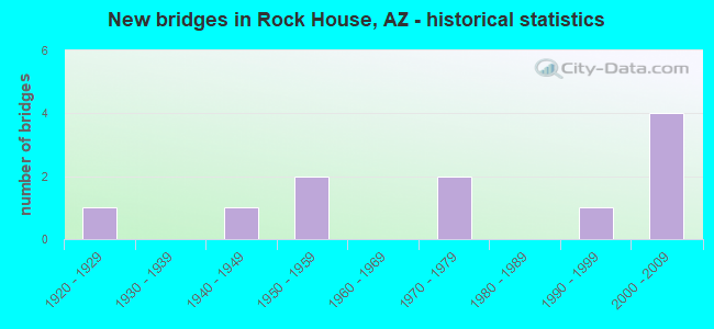
- New bridges - historical statistics
- 11920-1929
- 11940-1949
- 21950-1959
- 21970-1979
- 11990-1999
- 42000-2009
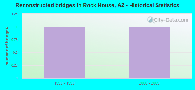
- Reconstructed bridges - Historical Statistics
- 11990-1999
- 12000-2009
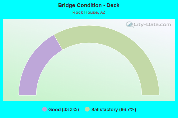
- Bridge Condition - Deck
- 33.3%Good
- 66.7%Satisfactory
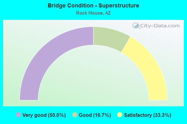
- Bridge Condition - Superstructure
- 50.0%Very good
- 16.7%Good
- 33.3%Satisfactory
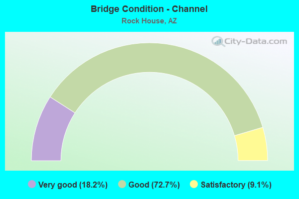
- Bridge Condition - Channel
- 18.2%Very good
- 72.7%Good
- 9.1%Satisfactory
Find on map >> Show street view
Structure Number: 37, Location: 04.3 Mi N Jct SR 88 (Lat: 33.619200, Lng: -110.921800), Route carried "on" structure: State highway 288, Year Built: 1920, Status: Open, Structure Length: 6.71m (22.01ft), Average Daily Traffic: 114 (year 2017), Truck Traffic: 9%, Average Future Daily Traffic: 124 (year 2037), Design Load: H 15, Features Intersected: Salt River
Minimum Vertical Clearance: 3.79m (12.43ft), Kilometerpoint: 422.356, Lanes on structure: 1, Owner: State Highway Agency, Approaching Roadway Width: 5.5m (18.0ft), Material/Design: Steel, Design/Construction: Truss - Thru, Number Of Spans In Main Unit: 1, Length of Maximum Span: 65.5m (214.9ft), Curb or Sidewalk Widths: Left: 0.2m (0.7ft), Right: 0.2m (0.7ft), Curb-To-Curb Width: 5.5m (18.0ft), Out-to-Out Width: 5.9m (19.4ft)
Condition: Deck: Satisfactory, Superstructure: Satisfactory, Substructure: Good, Channel: Very good, Operating Rating: 52.6 metric tons, Method Used To Determine Operating Rating: Allowable Stress (AS), Inventory Rating: 35.4 metric tons, Method Used To Determine Inventory Rating: Allowable Stress (AS), Structural Evaluation: Equal to present minimum criteria, Deck Geometry: High priority of corrective action, Waterway Adequacy: Equal to present desirable criteria, Approach Roadway Alignment: High priority of corrective action, Length Of Structure Improvement: 7.65m (25.10ft), Designated Inspection Frequency: Every 24 months, Critical Feature Inspection Frequency: Every 24 months, Inspection Date: May 2020, Critical Feature Inspection Date: May 2020, Total Project Cost: $1,000 ( Estimate for 2020), Deck Structure Type: Concrete Cast-file-Place, Wearing Surface/Protective System: Wearing Surface: Monolithic Concrete
Find on map >> Show street view
Structure Number: 1751, Location: 7.3 mi S Jct B 19 (Lat: 31.803900, Lng: -111.014500), Route carried "on" structure: Interstate 19, Year Built: 1976, Status: Open, Structure Length: 5.15m (16.90ft), Average Daily Traffic: 25,499 (year 2017), Truck Traffic: 15%, Average Future Daily Traffic: 25,509 (year 2037), Design Load: HS 20+Mod, Features Intersected: Esperanza Wash
Minimum Vertical Clearance: 30+ m (98+ ft), Kilometerpoint: 57.808, Lanes on structure: 2, Owner: State Highway Agency, Approaching Roadway Width: 11.6m (38.1ft), Skew: 3 degrees, Material/Design: Concrete continuous, Design/Construction: Slab, Number Of Spans In Main Unit: 7, Length of Maximum Span: 7.6m (24.9ft), Curb-To-Curb Width: 12.8m (42.0ft), Out-to-Out Width: 13.6m (44.6ft)
Condition: Deck: Satisfactory, Superstructure: Good, Substructure: Good, Channel: Good, Operating Rating: 51.7 metric tons, Method Used To Determine Operating Rating: Load Factor (LF), Inventory Rating: 30.8 metric tons, Method Used To Determine Inventory Rating: Load Factor (LF), Structural Evaluation: Better than present minimum criteria, Deck Geometry: Equal to present desirable criteria, Waterway Adequacy: Better than present minimum criteria, Approach Roadway Alignment: Equal to present desirable criteria, Designated Inspection Frequency: Every 24 months, Inspection Date: April 2021, Deck Structure Type: Concrete Cast-file-Place, Wearing Surface/Protective System: Wearing Surface: Bituminous
Find on map >> Show street view
Structure Number: 2582, Location: 1.70 mi W Jct SR288 (Lat: 33.581806, Lng: -110.970806), Route carried "on" structure: State highway 188, Year Built: 2005, Status: Open, Structure Length: 16.28m (53.41ft), Average Daily Traffic: 1,066 (year 2018), Truck Traffic: 10%, Average Future Daily Traffic: 1,076 (year 2040), Design Load: HS 20, Features Intersected: Quail Springs Wash
Minimum Vertical Clearance: 30+ m (98+ ft), Kilometerpoint: 372.180, Lanes on structure: 3, Owner: State Highway Agency, Approaching Roadway Width: 15.8m (51.8ft), Skew: 2 degrees, Material/Design: Prestressed concrete continuous, Design/Construction: Stringer/Multi-beam, Number Of Spans In Main Unit: 4, Length of Maximum Span: 40.5m (132.9ft), Curb-To-Curb Width: 15.8m (51.8ft), Out-to-Out Width: 16.8m (55.1ft)
Condition: Deck: Good, Superstructure: Very good, Substructure: Good, Channel: Good, Operating Rating: 89.8 metric tons, Method Used To Determine Operating Rating: Load Factor (LF), Inventory Rating: 36.3 metric tons, Method Used To Determine Inventory Rating: Load Factor (LF), Structural Evaluation: Better than present minimum criteria, Deck Geometry: Better than present minimum criteria, Waterway Adequacy: Better than present minimum criteria, Approach Roadway Alignment: Equal to present desirable criteria, Designated Inspection Frequency: Every 24 months, Inspection Date: March 2020, Deck Structure Type: Concrete Cast-file-Place, Wearing Surface/Protective System: Wearing Surface: Monolithic Concrete
Find on map >> Show street view
Structure Number: 2583, Location: 0.35 mi W Jct SR288 (Lat: 33.570139, Lng: -110.954111), Route carried "on" structure: State highway 188, Year Built: 2005, Status: Open, Structure Length: 7.96m (26.12ft), Average Daily Traffic: 1,066 (year 2018), Truck Traffic: 10%, Average Future Daily Traffic: 1,076 (year 2040), Design Load: HS 20, Features Intersected: Apprentice Wash
Minimum Vertical Clearance: 30+ m (98+ ft), Kilometerpoint: 370.170, Lanes on structure: 3, Owner: State Highway Agency, Approaching Roadway Width: 15.8m (51.8ft), Skew: 3 degrees, Material/Design: Prestressed concrete continuous, Design/Construction: Stringer/Multi-beam, Number Of Spans In Main Unit: 3, Length of Maximum Span: 28.7m (94.2ft), Curb-To-Curb Width: 15.8m (51.8ft), Out-to-Out Width: 16.8m (55.1ft)
Condition: Deck: Satisfactory, Superstructure: Very good, Substructure: Good, Channel: Good, Operating Rating: 89.8 metric tons, Method Used To Determine Operating Rating: Load Factor (LF), Inventory Rating: 38.1 metric tons, Method Used To Determine Inventory Rating: Load Factor (LF), Structural Evaluation: Better than present minimum criteria, Deck Geometry: Better than present minimum criteria, Waterway Adequacy: Better than present minimum criteria, Approach Roadway Alignment: Equal to present desirable criteria, Designated Inspection Frequency: Every 24 months, Inspection Date: March 2020, Deck Structure Type: Concrete Cast-file-Place, Wearing Surface/Protective System: Wearing Surface: Monolithic Concrete
Find on map >> Show street view
Structure Number: 2587, Location: 0.45 mi N Jct SR188 (Lat: 33.569661, Lng: -110.948039), Route carried "on" structure: State highway 288, Year Built: 2005, Status: Open, Structure Length: 11.43m (37.50ft), Average Daily Traffic: 110 (year 2018), Truck Traffic: 11%, Average Future Daily Traffic: 120 (year 2038), Design Load: HS 20, Features Intersected: Poison Springs Wash
Minimum Vertical Clearance: 30+ m (98+ ft), Kilometerpoint: 416.015, Lanes on structure: 2, Owner: State Highway Agency, Approaching Roadway Width: 11.0m (36.1ft), Skew: 2 degrees, Material/Design: Prestressed concrete continuous, Design/Construction: Stringer/Multi-beam, Number Of Spans In Main Unit: 4, Length of Maximum Span: 28.3m (92.8ft), Curb-To-Curb Width: 13.4m (44.0ft), Out-to-Out Width: 14.4m (47.2ft)
Condition: Deck: Good, Superstructure: Very good, Substructure: Good, Channel: Very good, Operating Rating: 89.8 metric tons, Method Used To Determine Operating Rating: Load Factor (LF), Inventory Rating: 35.4 metric tons, Method Used To Determine Inventory Rating: Load Factor (LF), Structural Evaluation: Better than present minimum criteria, Deck Geometry: Superior to present desirable criteria, Waterway Adequacy: Equal to present desirable criteria, Approach Roadway Alignment: Equal to present desirable criteria, Designated Inspection Frequency: Every 24 months, Inspection Date: March 2020, Deck Structure Type: Concrete Cast-file-Place, Wearing Surface/Protective System: Wearing Surface: Monolithic Concrete
Find on map >> Show street view
Structure Number: 4695, Location: 11.9 mi South Co Bdry (Lat: 31.563600, Lng: -111.052700), Route carried "on" structure: ServiceState highway 19, Year Built: 1952, Status: Open, Structure Length: 0.64m (2.10ft), Average Daily Traffic: 350 (year 2020), Truck Traffic: 8%, Average Future Daily Traffic: 360 (year 2040), Design Load: HS 20, Features Intersected: Rock Corral Canyon
Minimum Vertical Clearance: 30+ m (98+ ft), Kilometerpoint: 29.161, Lanes on structure: 2, Owner: State Highway Agency, Approaching Roadway Width: 12.2m (40.0ft), Material/Design: Concrete continuous, Design/Construction: Culvert, Number Of Spans In Main Unit: 2, Length of Maximum Span: 3.0m (9.8ft)
Condition: Channel: Good, Culverts: Good, Operating Rating: 89.8 metric tons, Method Used To Determine Operating Rating: Load Factor (LF), Inventory Rating: 89.8 metric tons, Method Used To Determine Inventory Rating: Load Factor (LF), Structural Evaluation: Better than present minimum criteria, Waterway Adequacy: Equal to present desirable criteria, Approach Roadway Alignment: Equal to present desirable criteria, Designated Inspection Frequency: Every 48 months, Inspection Date: May 2020
Find on map >> Show street view
Structure Number: 6237, Location: 11.6 mi E Jct SR 188 (Lat: 33.603500, Lng: -111.008100), Route carried "on" structure: State highway 188, Year Built: 1972, Year Reconstructed: 2004, Status: Open, Structure Length: 1.13m (3.71ft), Average Daily Traffic: 956 (year 2016), Truck Traffic: 11%, Average Future Daily Traffic: 966 (year 2038), Design Load: HS 20, Features Intersected: Spring Creek
Minimum Vertical Clearance: 30+ m (98+ ft), Kilometerpoint: 376.580, Lanes on structure: 2, Owner: State Highway Agency, Approaching Roadway Width: 17.1m (56.1ft), Skew: 3 degrees, Material/Design: Concrete continuous, Design/Construction: Culvert, Number Of Spans In Main Unit: 3, Length of Maximum Span: 3.0m (9.8ft)
Condition: Channel: Good, Culverts: Good, Operating Rating: 89.8 metric tons, Method Used To Determine Operating Rating: Load Factor (LF), Inventory Rating: 89.8 metric tons, Method Used To Determine Inventory Rating: Load Factor (LF), Structural Evaluation: Better than present minimum criteria, Waterway Adequacy: Better than present minimum criteria, Approach Roadway Alignment: Equal to present desirable criteria, Designated Inspection Frequency: Every 48 months, Inspection Date: March 2018
Find on map >> Show street view
Structure Number: 6838, Location: 2.4 mi N Jct SR 188 (Lat: 33.596650, Lng: -110.942392), Route carried "on" structure: State highway 288, Year Built: 1942, Year Reconstructed: 2014, Status: Open, Structure Length: 0.61m (2.00ft), Average Daily Traffic: 3,207 (year 2018), Truck Traffic: 10%, Average Future Daily Traffic: 3,217 (year 2040), Design Load: HS 20, Features Intersected: Eads Wash
Minimum Vertical Clearance: 30+ m (98+ ft), Kilometerpoint: 419.041, Lanes on structure: 2, Owner: State Highway Agency, Approaching Roadway Width: 7.3m (24.0ft), Material/Design: Concrete, Design/Construction: Culvert, Number Of Spans In Main Unit: 1, Length of Maximum Span: 6.1m (20.0ft)
Condition: Channel: Good, Culverts: Good, Operating Rating: 89.8 metric tons, Method Used To Determine Operating Rating: Load Factor (LF), Inventory Rating: 89.8 metric tons, Method Used To Determine Inventory Rating: Load Factor (LF), Structural Evaluation: Better than present minimum criteria, Waterway Adequacy: Equal to present desirable criteria, Approach Roadway Alignment: Equal to present minimum criteria, Designated Inspection Frequency: Every 48 months, Inspection Date: Febuary 2020
Find on map >> Show street view
Structure Number: 7011, Location: 10.2 mi N Jct SR 188 (Lat: 33.681950, Lng: -110.977431), Route carried "on" structure: State highway 288, Year Built: 1995, Status: Open, Structure Length: 1.40m (4.59ft), Average Daily Traffic: 3,207 (year 2018), Truck Traffic: 10%, Average Future Daily Traffic: 3,217 (year 2040), Design Load: HS 20, Features Intersected: Griffin Wash
Minimum Vertical Clearance: 30+ m (98+ ft), Kilometerpoint: 431.513, Lanes on structure: 2, Owner: State Highway Agency, Approaching Roadway Width: 7.9m (25.9ft), Skew: 2 degrees, Material/Design: Concrete continuous, Design/Construction: Culvert, Number Of Spans In Main Unit: 4, Length of Maximum Span: 3.0m (9.8ft)
Condition: Channel: Good, Culverts: Good, Operating Rating: 89.8 metric tons, Method Used To Determine Operating Rating: Load Factor (LF), Inventory Rating: 89.8 metric tons, Method Used To Determine Inventory Rating: Load Factor (LF), Structural Evaluation: Better than present minimum criteria, Waterway Adequacy: Equal to present desirable criteria, Approach Roadway Alignment: Equal to present desirable criteria, Designated Inspection Frequency: Every 48 months, Inspection Date: Febuary 2020
Find on map >> Show street view
Structure Number: 7133, Location: 2.55 mi. W. Jct. SR288 (Lat: 33.588500, Lng: -110.984000), Route carried "on" structure: State highway 188, Year Built: 2005, Status: Open, Structure Length: 1.10m (3.61ft), Average Daily Traffic: 956 (year 2016), Truck Traffic: 11%, Average Future Daily Traffic: 966 (year 2038), Design Load: HS 20, Features Intersected: Wash
Minimum Vertical Clearance: 30+ m (98+ ft), Kilometerpoint: 373.710, Lanes on structure: 3, Owner: State Highway Agency, Approaching Roadway Width: 14.6m (47.9ft), Skew: 5 degrees, Material/Design: Concrete continuous, Design/Construction: Culvert, Number Of Spans In Main Unit: 2, Length of Maximum Span: 3.0m (9.8ft)
Condition: Channel: Good, Culverts: Good, Operating Rating: 74.4 metric tons, Method Used To Determine Operating Rating: Load Factor (LF), Inventory Rating: 44.5 metric tons, Method Used To Determine Inventory Rating: Load Factor (LF), Structural Evaluation: Better than present minimum criteria, Waterway Adequacy: Better than present minimum criteria, Approach Roadway Alignment: Equal to present desirable criteria, Designated Inspection Frequency: Every 48 months, Inspection Date: March 2018
Find on map >> Show street view
Structure Number: 20075, Location: 500 ft N Jct SR 188 (Lat: 33.604831, Lng: -111.008208), Route carried "on" structure: ServiceState highway 188, Year Built: 1954, Status: Open, Structure Length: 1.22m (4.00ft), Average Daily Traffic: 100 (year 2020), Average Future Daily Traffic: 110 (year 2040), Design Load: HS 20, Features Intersected: Spring Creek, Facility Carried by Structure: Hayhook Rd
Minimum Vertical Clearance: 30+ m (98+ ft), Kilometerpoint: 376.586, Lanes on structure: 2, Owner: State Highway Agency, Approaching Roadway Width: 6.1m (20.0ft), Material/Design: Concrete, Design/Construction: Tee Beam, Number Of Spans In Main Unit: 1, Length of Maximum Span: 11.9m (39.0ft), Curb or Sidewalk Widths: Left: 0.2m (0.7ft), Right: 0.2m (0.7ft), Curb-To-Curb Width: 6.1m (20.0ft), Out-to-Out Width: 7.0m (23.0ft)
Condition: Deck: Satisfactory, Superstructure: Satisfactory, Substructure: Good, Channel: Satisfactory, Operating Rating: 33.6 metric tons, Method Used To Determine Operating Rating: Load Factor (LF), Inventory Rating: 20.0 metric tons, Method Used To Determine Inventory Rating: Load Factor (LF), Structural Evaluation: Somewhat better than minimum adequacy, Deck Geometry: Somewhat better than minimum adequacy, Waterway Adequacy: Better than present minimum criteria, Approach Roadway Alignment: Equal to present minimum criteria, Designated Inspection Frequency: Every 24 months, Inspection Date: March 2020, Deck Structure Type: Concrete Cast-file-Place, Wearing Surface/Protective System: Wearing Surface: Monolithic Concrete