Bridge Statistics for Rockport, Texas (TX)
Condition, Traffic, Stress, Structural Evaluation, Project Costs
- National Bridge Inventory (NBI) Statistics
- 16Number of bridges
- 262ft / 79.7mTotal length
- $8,000Total costs
- 65,789Total average daily traffic
- 6,200Total average daily truck traffic
- National Bridge Inventory (NBI) Registered Bridges for Rockport
- No street view available for this location
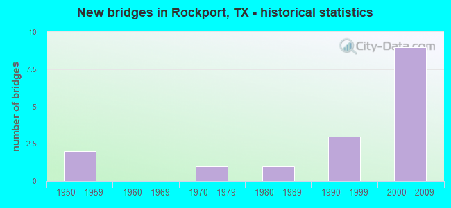
- New bridges - historical statistics
- 21950-1959
- 11970-1979
- 11980-1989
- 31990-1999
- 92000-2009
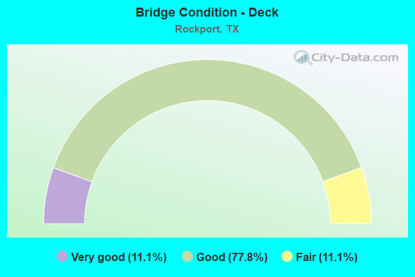
- Bridge Condition - Deck
- 11.1%Very good
- 77.8%Good
- 11.1%Fair
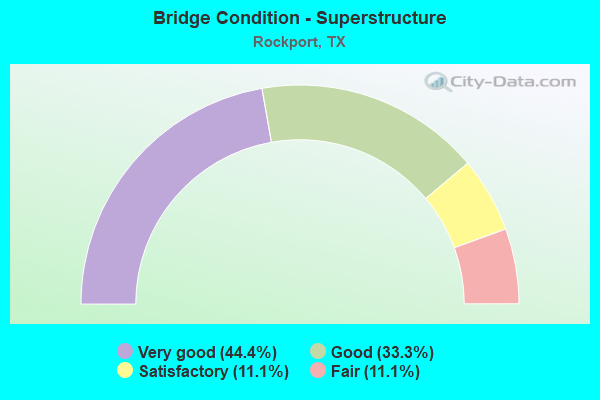
- Bridge Condition - Superstructure
- 44.4%Very good
- 33.3%Good
- 11.1%Satisfactory
- 11.1%Fair
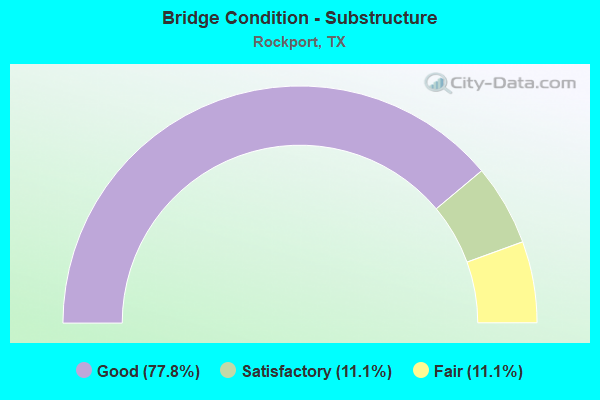
- Bridge Condition - Substructure
- 77.8%Good
- 11.1%Satisfactory
- 11.1%Fair
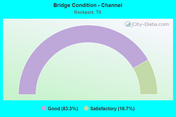
- Bridge Condition - Channel
- 83.3%Good
- 16.7%Satisfactory
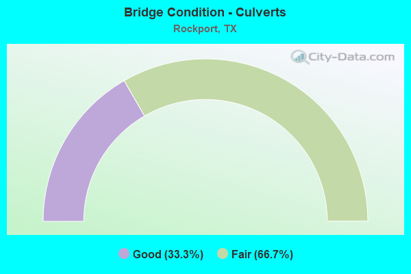
- Bridge Condition - Culverts
- 33.3%Good
- 66.7%Fair
Find on map >> Show street view
Structure Number: 160040018003071, Location: 5.6 MI N OF PR 13 (Lat: 28.217392, Lng: -96.987875), Route carried "on" structure: State highway 35, Year Built: 2006, Status: Open, Structure Length: 21.79m (71.49ft), Average Daily Traffic: 4,026 (year 2020), Truck Traffic: 15%, Average Future Daily Traffic: 4,640 (year 2033), Design Load: HS 20, Features Intersected: CAVASSO CREEK
Minimum Vertical Clearance: 30+ m (98+ ft), Kilometerpoint: 9.700, Lanes on structure: 2, Owner: State Highway Agency, Approaching Roadway Width: 13.4m (44.0ft), Material/Design: Prestressed concrete, Number Of Spans In Main Unit: 13, Length of Maximum Span: 16.8m (55.1ft), Curb-To-Curb Width: 13.4m (44.0ft), Out-to-Out Width: 14.0m (45.9ft)
Condition: Deck: Good, Superstructure: Good, Substructure: Good, Channel: Good, Operating Rating: 54.4 metric tons, Method Used To Determine Operating Rating: Assigned rating based on Load Factor Design (LFD) reported in metric tons, Inventory Rating: 32.7 metric tons, Method Used To Determine Inventory Rating: Assigned rating based on Load Factor Design (LFD) reported in metric tons, Structural Evaluation: Better than present minimum criteria, Deck Geometry: Better than present minimum criteria, Waterway Adequacy: Superior to present desirable criteria, Approach Roadway Alignment: Equal to present desirable criteria, Designated Inspection Frequency: Every 24 months, Inspection Date: Febuary 2020, Deck Structure Type: Concrete Cast-file-Place
Find on map >> Show street view
Structure Number: 160040018004056, Location: 2.7 MI S OF FM 3036 (Lat: 28.029561, Lng: -97.082219), Route carried "on" structure: State highway 35, Year Built: 1995, Status: Open, Structure Length: 8.23m (27.00ft), Average Daily Traffic: 4,883 (year 2020), Truck Traffic: 9%, Average Future Daily Traffic: 24,640 (year 2030), Design Load: HS 20, Features Intersected: FM 1069
Minimum Vertical Clearance: 30+ m (98+ ft), Kilometerpoint: 12.585, Lanes on structure: 2, Lanes under structure: 6, Owner: State Highway Agency, Approaching Roadway Width: 13.4m (44.0ft), Material/Design: Prestressed concrete, Design/Construction: Stringer/Multi-beam, Number Of Spans In Main Unit: 3, Length of Maximum Span: 30.5m (100.1ft), Curb-To-Curb Width: 11.3m (37.1ft), Out-to-Out Width: 12.2m (40.0ft)
Condition: Deck: Good, Superstructure: Good, Substructure: Good, Operating Rating: 54.4 metric tons, Method Used To Determine Operating Rating: Assigned rating based on Load Factor Design (LFD) reported in metric tons, Inventory Rating: 32.7 metric tons, Method Used To Determine Inventory Rating: Assigned rating based on Load Factor Design (LFD) reported in metric tons, Structural Evaluation: Better than present minimum criteria, Deck Geometry: Equal to present minimum criteria, Underclear: Superior to present desirable criteria, Approach Roadway Alignment: Equal to present desirable criteria, Designated Inspection Frequency: Every 24 months, Inspection Date: Febuary 2020, Deck Structure Type: Concrete Precast Panels
Find on map >> Show street view
Structure Number: 160040018004064, Location: 0.75 MI S OF FM 3036 (Lat: 28.050022, Lng: -97.041803), Route carried "on" structure: Business State highway 35, Year Built: 1996, Status: Open, Structure Length: 1.19m (3.90ft), Average Daily Traffic: 7,240 (year 2016), Truck Traffic: 14%, Average Future Daily Traffic: 12,150 (year 2038), Design Load: HS 20, Features Intersected: TULE CREEK
Minimum Vertical Clearance: 30+ m (98+ ft), Kilometerpoint: 2.395, Lanes on structure: 4, Owner: State Highway Agency, Approaching Roadway Width: 18.9m (62.0ft), Material/Design: Concrete, Design/Construction: Culvert, Number Of Spans In Main Unit: 4, Length of Maximum Span: 2.4m (7.9ft), Curb or Sidewalk Widths: Left: 1.6m (5.2ft), Right: 1.4m (4.6ft), Curb-To-Curb Width: 19.1m (62.7ft), Out-to-Out Width: 22.9m (75.1ft)
Condition: Channel: Good, Culverts: Good, Operating Rating: 39.9 metric tons, Method Used To Determine Operating Rating: Load Factor (LF), Inventory Rating: 23.6 metric tons, Method Used To Determine Inventory Rating: Load Factor (LF), Structural Evaluation: Somewhat better than minimum adequacy, Deck Geometry: Equal to present minimum criteria, Waterway Adequacy: Equal to present minimum criteria, Approach Roadway Alignment: Equal to present desirable criteria, Designated Inspection Frequency: Every 48 months, Inspection Date: Febuary 2020, Deck Structure Type: Concrete Cast-file-Place, Wearing Surface/Protective System: Wearing Surface: Bituminous
Find on map >> Show street view
Structure Number: 160040018004066, Location: INT OF US 35 & SH 188 (Lat: 27.968519, Lng: -97.124547), Route carried "on" structure: State highway 35, Year Built: 2004, Status: Open, Structure Length: 8.23m (27.00ft), Average Daily Traffic: 8,162 (year 2019), Truck Traffic: 10%, Average Future Daily Traffic: 5,750 (year 2033), Design Load: HS 20, Features Intersected: SH 188
Minimum Vertical Clearance: 30+ m (98+ ft), Kilometerpoint: 28.336, Lanes on structure: 2, Lanes under structure: 4, Owner: State Highway Agency, Approaching Roadway Width: 12.8m (42.0ft), Material/Design: Prestressed concrete, Design/Construction: Stringer/Multi-beam, Number Of Spans In Main Unit: 3, Length of Maximum Span: 30.5m (100.1ft), Curb-To-Curb Width: 11.1m (36.4ft), Out-to-Out Width: 12.0m (39.4ft)
Condition: Deck: Good, Superstructure: Good, Substructure: Good, Operating Rating: 54.4 metric tons, Method Used To Determine Operating Rating: Assigned rating based on Load Factor Design (LFD) reported in metric tons, Inventory Rating: 32.7 metric tons, Method Used To Determine Inventory Rating: Assigned rating based on Load Factor Design (LFD) reported in metric tons, Structural Evaluation: Better than present minimum criteria, Deck Geometry: Equal to present minimum criteria, Underclear: Equal to present minimum criteria, Approach Roadway Alignment: Equal to present desirable criteria, Designated Inspection Frequency: Every 24 months, Inspection Date: Febuary 2020, Deck Structure Type: Concrete Precast Panels
Find on map >> Show street view
Structure Number: 160040018004067, Location: INT OF US 35 & SH 188 (Lat: 27.968661, Lng: -97.124842), Route carried "on" structure: State highway 35, Year Built: 2004, Status: Open, Structure Length: 8.23m (27.00ft), Average Daily Traffic: 7,475 (year 2019), Truck Traffic: 10%, Average Future Daily Traffic: 5,750 (year 2033), Design Load: HS 20, Features Intersected: SH 188
Minimum Vertical Clearance: 30+ m (98+ ft), Kilometerpoint: 28.336, Lanes on structure: 2, Lanes under structure: 4, Owner: State Highway Agency, Approaching Roadway Width: 11.6m (38.1ft), Material/Design: Prestressed concrete, Design/Construction: Stringer/Multi-beam, Number Of Spans In Main Unit: 3, Length of Maximum Span: 30.5m (100.1ft), Curb-To-Curb Width: 11.1m (36.4ft), Out-to-Out Width: 12.0m (39.4ft)
Condition: Deck: Good, Superstructure: Very good, Substructure: Good, Operating Rating: 54.4 metric tons, Method Used To Determine Operating Rating: Assigned rating based on Load Factor Design (LFD) reported in metric tons, Inventory Rating: 32.7 metric tons, Method Used To Determine Inventory Rating: Assigned rating based on Load Factor Design (LFD) reported in metric tons, Structural Evaluation: Better than present minimum criteria, Deck Geometry: Equal to present minimum criteria, Underclear: Equal to present minimum criteria, Approach Roadway Alignment: Equal to present desirable criteria, Designated Inspection Frequency: Every 24 months, Inspection Date: Febuary 2020, Deck Structure Type: Concrete Precast Panels
Find on map >> Show street view
Structure Number: 160040018004068, Location: 2.7 MI S OF FM 3036 (Lat: 28.029447, Lng: -97.081911), Route carried "on" structure: State highway 35, Year Built: 2004, Status: Open, Structure Length: 8.23m (27.00ft), Average Daily Traffic: 4,774 (year 2020), Truck Traffic: 10%, Average Future Daily Traffic: 4,470 (year 2033), Design Load: HS 20, Features Intersected: FM 1069
Minimum Vertical Clearance: 30+ m (98+ ft), Kilometerpoint: 20.352, Lanes on structure: 2, Lanes under structure: 6, Owner: State Highway Agency, Approaching Roadway Width: 11.6m (38.1ft), Material/Design: Prestressed concrete, Design/Construction: Stringer/Multi-beam, Number Of Spans In Main Unit: 3, Length of Maximum Span: 30.5m (100.1ft), Curb-To-Curb Width: 11.1m (36.4ft), Out-to-Out Width: 12.0m (39.4ft)
Condition: Deck: Good, Superstructure: Very good, Substructure: Good, Operating Rating: 54.4 metric tons, Method Used To Determine Operating Rating: Assigned rating based on Load Factor Design (LFD) reported in metric tons, Inventory Rating: 32.7 metric tons, Method Used To Determine Inventory Rating: Assigned rating based on Load Factor Design (LFD) reported in metric tons, Structural Evaluation: Better than present minimum criteria, Deck Geometry: Equal to present minimum criteria, Underclear: Meets minimum limits, Approach Roadway Alignment: Equal to present desirable criteria, Designated Inspection Frequency: Every 24 months, Inspection Date: Febuary 2020, Deck Structure Type: Concrete Precast Panels
Find on map >> Show street view
Structure Number: 160040018004069, Location: 0.8 MI SW OF FM 3036 (Lat: 28.053364, Lng: -97.068703), Route carried "on" structure: State highway 35, Year Built: 2004, Status: Open, Structure Length: 8.84m (29.00ft), Average Daily Traffic: 4,774 (year 2020), Truck Traffic: 11%, Average Future Daily Traffic: 4,450 (year 2033), Design Load: HS 20, Features Intersected: FM 2165
Minimum Vertical Clearance: 30+ m (98+ ft), Kilometerpoint: 17.379, Lanes on structure: 2, Lanes under structure: 4, Owner: State Highway Agency, Approaching Roadway Width: 11.6m (38.1ft), Skew: 2 degrees, Material/Design: Prestressed concrete, Design/Construction: Stringer/Multi-beam, Number Of Spans In Main Unit: 3, Length of Maximum Span: 30.5m (100.1ft), Curb-To-Curb Width: 11.4m (37.4ft), Out-to-Out Width: 12.0m (39.4ft)
Condition: Deck: Good, Superstructure: Very good, Substructure: Good, Operating Rating: 54.4 metric tons, Method Used To Determine Operating Rating: Assigned rating based on Load Factor Design (LFD) reported in metric tons, Inventory Rating: 32.7 metric tons, Method Used To Determine Inventory Rating: Assigned rating based on Load Factor Design (LFD) reported in metric tons, Structural Evaluation: Better than present minimum criteria, Deck Geometry: Equal to present minimum criteria, Underclear: Superior to present desirable criteria, Approach Roadway Alignment: Equal to present desirable criteria, Designated Inspection Frequency: Every 24 months, Inspection Date: Febuary 2020, Deck Structure Type: Concrete Precast Panels
Find on map >> Show street view
Structure Number: 16004001800407, Location: 0.8 MI SW OF FM 3036 (Lat: 28.053633, Lng: -97.068928), Route carried "on" structure: State highway 35, Year Built: 2004, Status: Open, Structure Length: 8.84m (29.00ft), Average Daily Traffic: 4,877 (year 2020), Truck Traffic: 11%, Average Future Daily Traffic: 4,450 (year 2033), Design Load: HS 20, Features Intersected: FM 2165
Minimum Vertical Clearance: 30+ m (98+ ft), Kilometerpoint: 17.379, Lanes on structure: 2, Lanes under structure: 4, Owner: State Highway Agency, Approaching Roadway Width: 11.6m (38.1ft), Skew: 2 degrees, Material/Design: Prestressed concrete, Design/Construction: Stringer/Multi-beam, Number Of Spans In Main Unit: 3, Length of Maximum Span: 30.5m (100.1ft), Curb-To-Curb Width: 11.1m (36.4ft), Out-to-Out Width: 12.0m (39.4ft)
Condition: Deck: Good, Superstructure: Very good, Substructure: Good, Operating Rating: 54.4 metric tons, Method Used To Determine Operating Rating: Assigned rating based on Load Factor Design (LFD) reported in metric tons, Inventory Rating: 32.7 metric tons, Method Used To Determine Inventory Rating: Assigned rating based on Load Factor Design (LFD) reported in metric tons, Structural Evaluation: Better than present minimum criteria, Deck Geometry: Equal to present minimum criteria, Underclear: Equal to present desirable criteria, Approach Roadway Alignment: Equal to present desirable criteria, Designated Inspection Frequency: Every 24 months, Inspection Date: Febuary 2020, Deck Structure Type: Concrete Precast Panels
Find on map >> Show street view
Structure Number: 160040050704006, Location: 3.25 MI N OF SH 188 (Lat: 28.020192, Lng: -97.119375), Route carried "on" structure: State highway 1069, Year Built: 1950, Status: Open, Structure Length: 0.67m (2.20ft), Average Daily Traffic: 2,314 (year 2020), Truck Traffic: 8%, Average Future Daily Traffic: 4,430 (year 2033), Features Intersected: DRAW
Minimum Vertical Clearance: 30+ m (98+ ft), Kilometerpoint: 17.255, Lanes on structure: 2, Owner: State Highway Agency, Approaching Roadway Width: 7.9m (25.9ft), Material/Design: Concrete, Design/Construction: Culvert, Number Of Spans In Main Unit: 4, Length of Maximum Span: 1.5m (4.9ft), Curb-To-Curb Width: 11.0m (36.1ft), Out-to-Out Width: 11.4m (37.4ft)
Condition: Channel: Good, Culverts: Fair, Operating Rating: 39.9 metric tons, Method Used To Determine Operating Rating: Load Factor (LF), Inventory Rating: 23.6 metric tons, Method Used To Determine Inventory Rating: Load Factor (LF), Structural Evaluation: Somewhat better than minimum adequacy, Deck Geometry: Somewhat better than minimum adequacy, Waterway Adequacy: Equal to present minimum criteria, Approach Roadway Alignment: Equal to present desirable criteria, Length Of Structure Improvement: 0.67m (2.20ft), Designated Inspection Frequency: Every 24 months, Inspection Date: Febuary 2020, Deck Structure Type: Concrete Cast-file-Place, Wearing Surface/Protective System: Wearing Surface: Bituminous
Find on map >> Show street view
Structure Number: 160040050704007, Location: 4.1 MI N OF SH 188 (Lat: 28.025797, Lng: -97.107450), Route carried "on" structure: State highway 1069, Year Built: 1950, Status: Open, Structure Length: 0.67m (2.20ft), Average Daily Traffic: 2,314 (year 2020), Truck Traffic: 8%, Average Future Daily Traffic: 4,430 (year 2033), Features Intersected: DRAW
Minimum Vertical Clearance: 30+ m (98+ ft), Kilometerpoint: 15.894, Lanes on structure: 2, Owner: State Highway Agency, Approaching Roadway Width: 7.6m (24.9ft), Material/Design: Concrete, Design/Construction: Culvert, Number Of Spans In Main Unit: 4, Length of Maximum Span: 1.5m (4.9ft), Curb-To-Curb Width: 10.9m (35.8ft), Out-to-Out Width: 11.4m (37.4ft)
Condition: Channel: Good, Culverts: Fair, Operating Rating: 39.9 metric tons, Method Used To Determine Operating Rating: Load Factor (LF), Inventory Rating: 23.6 metric tons, Method Used To Determine Inventory Rating: Load Factor (LF), Structural Evaluation: Somewhat better than minimum adequacy, Deck Geometry: Somewhat better than minimum adequacy, Waterway Adequacy: Equal to present minimum criteria, Approach Roadway Alignment: Equal to present desirable criteria, Length Of Structure Improvement: 0.67m (2.20ft), Designated Inspection Frequency: Every 24 months, Inspection Date: Febuary 2020, Deck Structure Type: Concrete Cast-file-Place, Wearing Surface/Protective System: Wearing Surface: Bituminous
Find on map >> Show street view
Structure Number: 160040B00310001, Location: 1.10 MI NE OF SH 35 BUS (Lat: 28.048075, Lng: -97.033306), Route carried "on" structure: City street , Year Built: 1985, Status: Open, Structure Length: 3.60m (11.81ft), Average Daily Traffic: 2,500 (year 2015), Average Future Daily Traffic: 3,000 (year 2035), Features Intersected: CANAL, Facility Carried by Structure: BROADWAY ST
Minimum Vertical Clearance: 30+ m (98+ ft), Kilometerpoint: 1.770, Lanes on structure: 2, Owner: City or Municipal Highway Agency, Approaching Roadway Width: 7.9m (25.9ft), Material/Design: Prestressed concrete, Design/Construction: Box Beam or Girders - Multiple, Number Of Spans In Main Unit: 1, Number Of Approach Spans: 2, Length of Maximum Span: 15.2m (49.9ft), Curb-To-Curb Width: 8.0m (26.2ft), Out-to-Out Width: 8.5m (27.9ft)
Condition: Deck: Very good, Superstructure: Satisfactory, Substructure: Satisfactory, Channel: Good, Operating Rating: 32.7 metric tons, Method Used To Determine Operating Rating: Field evaluation and documented engineering judgment, Inventory Rating: 24.5 metric tons, Method Used To Determine Inventory Rating: Field evaluation and documented engineering judgment, Structural Evaluation: Equal to present minimum criteria, Deck Geometry: High priority of corrective action, Waterway Adequacy: Equal to present desirable criteria, Approach Roadway Alignment: Equal to present minimum criteria, Length Of Structure Improvement: 3.60m (11.81ft), Designated Inspection Frequency: Every 24 months, Underwater Inspection Frequency: Every 60 months, Inspection Date: May 2021, Underwater Inspection Date: September 2020, Bridge Improvement Cost: $6,000, Roadway Improvement Cost: $2,000, Total Project Cost: $8,000, Deck Structure Type: Concrete Precast Panels, Wearing Surface/Protective System: Wearing Surface: Bituminous
Find on map >> Show street view
Structure Number: 160040B00460001, Location: 0.05 MI E OF BROADWAY ST (Lat: 28.049497, Lng: -97.031033), Route carried "on" structure: City street , Year Built: 1975, Status: Posted for load, Structure Length: 1.13m (3.71ft), Average Daily Traffic: 1,000 (year 2015), Average Future Daily Traffic: 1,500 (year 2035), Features Intersected: CANAL, Facility Carried by Structure: BAYSHORE DR
Minimum Vertical Clearance: 30+ m (98+ ft), Kilometerpoint: 0.483, Lanes on structure: 2, Owner: City or Municipal Highway Agency, Approaching Roadway Width: 7.6m (24.9ft), Material/Design: Concrete, Number Of Spans In Main Unit: 1, Length of Maximum Span: 9.8m (32.2ft), Curb or Sidewalk Widths: Left: 1.1m (3.6ft), Right: 1.1m (3.6ft), Curb-To-Curb Width: 7.6m (24.9ft), Out-to-Out Width: 10.1m (33.1ft)
Condition: Deck: Fair, Superstructure: Fair, Substructure: Fair, Channel: Satisfactory, Operating Rating: 32.7 metric tons, Method Used To Determine Operating Rating: Field evaluation and documented engineering judgment, Inventory Rating: 24.5 metric tons, Method Used To Determine Inventory Rating: Field evaluation and documented engineering judgment, Structural Evaluation: Somewhat better than minimum adequacy, Deck Geometry: Meets minimum limits, Waterway Adequacy: Equal to present desirable criteria, Approach Roadway Alignment: Better than present minimum criteria, Designated Inspection Frequency: Every 24 months, Underwater Inspection Frequency: Every 60 months, Inspection Date: May 2021, Underwater Inspection Date: September 2018, Deck Structure Type: Concrete Precast Panels, Wearing Surface/Protective System: Wearing Surface: Bituminous
Structure Number: 160040018004056, Location: 2.7 MI S OF FM 3036, Route carried "under" structure: State highway 1069, Year Built: 1995, Structure Length: 0. m, Average Daily Traffic: 9,300 (year 2013), Truck Traffic: 7%, Features Intersected: FM 1069, Facility Carried by Structure: SH 35 SB
Minimum Vertical Clearance: 5.51m (18.08ft), Kilometerpoint: 13.222, Material/Design: Prestressed concrete, Design/Construction: Stringer/Multi-beam, Length of Maximum Span: 30.5m (100.1ft)
Minimum Vertical Clearance: 5.51m (18.08ft), Kilometerpoint: 13.222, Material/Design: Prestressed concrete, Design/Construction: Stringer/Multi-beam, Length of Maximum Span: 30.5m (100.1ft)
Structure Number: 160040018004068, Location: 2.7 MI S OF FM 3036, Route carried "under" structure: State highway 1069, Year Built: 2004, Structure Length: 0. m, Average Daily Traffic: 1,150 (year 2011), Truck Traffic: 2%, Features Intersected: FM 1069, Facility Carried by Structure: SH 35 NB
Minimum Vertical Clearance: 5.26m (17.26ft), Kilometerpoint: 2.897, Material/Design: Prestressed concrete, Design/Construction: Stringer/Multi-beam, Length of Maximum Span: 30.5m (100.1ft)
Minimum Vertical Clearance: 5.26m (17.26ft), Kilometerpoint: 2.897, Material/Design: Prestressed concrete, Design/Construction: Stringer/Multi-beam, Length of Maximum Span: 30.5m (100.1ft)
Structure Number: 160040018004069, Location: 0.8 MI SW OF FM 3036, Route carried "under" structure: State highway 2165, Year Built: 2004, Structure Length: 0. m, Average Daily Traffic: 500 (year 2010), Features Intersected: FM 2165, Facility Carried by Structure: SH 35 NB
Minimum Vertical Clearance: 5.16m (16.93ft), Kilometerpoint: 0.463, Material/Design: Prestressed concrete, Design/Construction: Stringer/Multi-beam, Length of Maximum Span: 30.5m (100.1ft)
Minimum Vertical Clearance: 5.16m (16.93ft), Kilometerpoint: 0.463, Material/Design: Prestressed concrete, Design/Construction: Stringer/Multi-beam, Length of Maximum Span: 30.5m (100.1ft)
Structure Number: 16004001800407, Location: 0.8 MI SW OF FM 3036, Route carried "under" structure: State highway 2165, Year Built: 2004, Structure Length: 0. m, Average Daily Traffic: 500 (year 2010), Features Intersected: FM 2165, Facility Carried by Structure: SH 35 SB
Minimum Vertical Clearance: 5.16m (16.93ft), Kilometerpoint: 0.463, Material/Design: Prestressed concrete, Design/Construction: Stringer/Multi-beam, Length of Maximum Span: 30.5m (100.1ft)
Minimum Vertical Clearance: 5.16m (16.93ft), Kilometerpoint: 0.463, Material/Design: Prestressed concrete, Design/Construction: Stringer/Multi-beam, Length of Maximum Span: 30.5m (100.1ft)