Bridge Statistics for Roebling, New Jersey (NJ)
Condition, Traffic, Stress, Structural Evaluation, Project Costs
- National Bridge Inventory (NBI) Statistics
- 46Number of bridges
- 495ft / 151mTotal length
- $6,644,000Total costs
- 1,522,151Total average daily traffic
- 164,093Total average daily truck traffic
- National Bridge Inventory (NBI) Registered Bridges for Roebling
- No street view available for this location
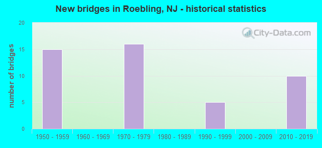
- New bridges - historical statistics
- 151950-1959
- 161970-1979
- 51990-1999
- 102010-2019
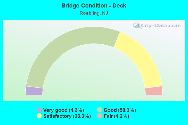
- Bridge Condition - Deck
- 4.2%Very good
- 58.3%Good
- 33.3%Satisfactory
- 4.2%Fair
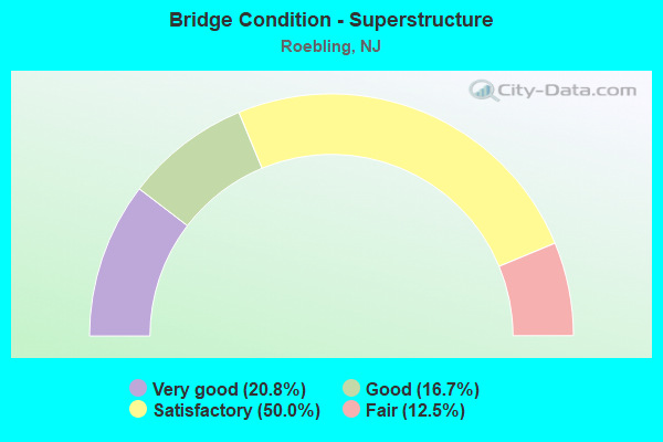
- Bridge Condition - Superstructure
- 20.8%Very good
- 16.7%Good
- 50.0%Satisfactory
- 12.5%Fair
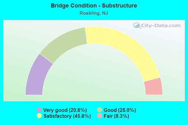
- Bridge Condition - Substructure
- 20.8%Very good
- 25.0%Good
- 45.8%Satisfactory
- 8.3%Fair
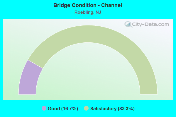
- Bridge Condition - Channel
- 16.7%Good
- 83.3%Satisfactory
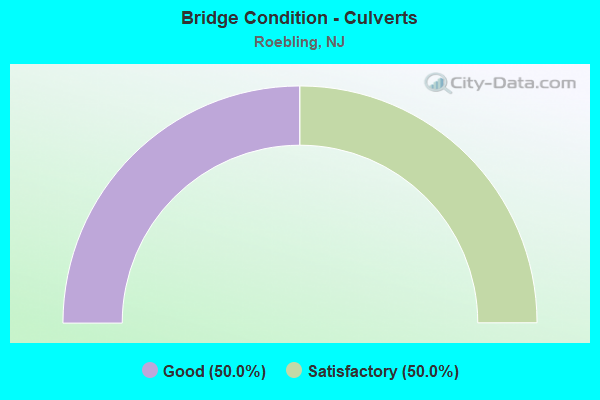
- Bridge Condition - Culverts
- 50.0%Good
- 50.0%Satisfactory
Find on map >> Show street view
Structure Number: 328156, Location: 0.47 MI S OF I-295 EXIT52 (Lat: 40.079381, Lng: -74.768581), Route carried "on" structure: County highway 543, Year Built: 1971, Status: Open, Structure Length: 9.39m (30.81ft), Average Daily Traffic: 3,581 (year 2020), Truck Traffic: 3%, Average Future Daily Traffic: 4,296 (year 2020), Design Load: HS 20, Features Intersected: I-295, Facility Carried by Structure: BURL-COLUMBUS RD
Minimum Vertical Clearance: 30.45m (99.90ft), Kilometerpoint: 35.196, Lanes on structure: 2, Lanes under structure: 6, Owner: State Highway Agency, Approaching Roadway Width: 9.1m (29.9ft), Skew: 5 degrees, Material/Design: Steel, Design/Construction: Stringer/Multi-beam, Number Of Spans In Main Unit: 2, Length of Maximum Span: 45.4m (149.0ft), Curb or Sidewalk Widths: Left: 0.3m (1.0ft), Right: 1.7m (5.6ft), Curb-To-Curb Width: 9.1m (29.9ft), Out-to-Out Width: 12.0m (39.4ft)
Condition: Deck: Satisfactory, Superstructure: Good, Substructure: Satisfactory, Operating Rating: 88.9 metric tons, Method Used To Determine Operating Rating: Load Factor (LF), Inventory Rating: 52.6 metric tons, Method Used To Determine Inventory Rating: Load Factor (LF), Structural Evaluation: Equal to present minimum criteria, Deck Geometry: Meets minimum limits, Underclear: High priority of corrective action, Approach Roadway Alignment: Better than present minimum criteria, Length Of Structure Improvement: 9.39m (30.81ft), Designated Inspection Frequency: Every 24 months, Inspection Date: August 2020, Bridge Improvement Cost: $1,243,000, Roadway Improvement Cost: $233,000, Total Project Cost: $1,809,000 ( Estimate for 2020), Deck Structure Type: Concrete Cast-file-Place, Wearing Surface/Protective System: Wearing Surface: Monolithic Concrete
Find on map >> Show street view
Structure Number: 328157, Location: 1 MI SW OF 295&NJTPK EXT (Lat: 40.083769, Lng: -74.761169), Route carried "on" structure: County highway 656, Year Built: 1971, Status: Open, Structure Length: 6.34m (20.80ft), Average Daily Traffic: 16,806 (year 2020), Truck Traffic: 4%, Average Future Daily Traffic: 20,167 (year 2040), Design Load: HL 93, Features Intersected: I-295, Facility Carried by Structure: FLORENCE-COLUM RD
Minimum Vertical Clearance: 30+ m (98+ ft), Kilometerpoint: 13.197, Lanes on structure: 4, Lanes under structure: 8, Owner: State Highway Agency, Approaching Roadway Width: 15.3m (50.2ft), Material/Design: Steel, Design/Construction: Stringer/Multi-beam, Number Of Spans In Main Unit: 2, Length of Maximum Span: 30.8m (101.0ft), Curb or Sidewalk Widths: Left: 0.5m (1.6ft), Right: 1.3m (4.3ft), Curb-To-Curb Width: 15.3m (50.2ft), Out-to-Out Width: 18.2m (59.7ft)
Condition: Deck: Satisfactory, Superstructure: Satisfactory, Substructure: Good, Operating Rating: 43.4 metric tons, Method Used To Determine Operating Rating: Load and Resistance Factor Rating (LRFR) rating reported by rating factor(RF) method using HL-93 loadings, Inventory Rating: 33.4 metric tons, Method Used To Determine Inventory Rating: Load and Resistance Factor Rating (LRFR) rating reported by rating factor(RF) method using HL-93 loadings, Structural Evaluation: Equal to present minimum criteria, Deck Geometry: High priority of corrective action, Underclear: Somewhat better than minimum adequacy, Approach Roadway Alignment: Equal to present minimum criteria, Length Of Structure Improvement: 6.34m (20.80ft), Designated Inspection Frequency: Every 24 months, Inspection Date: July 2020, Bridge Improvement Cost: $52,000, Roadway Improvement Cost: $6,000, Total Project Cost: $90,000 ( Estimate for 2020), Deck Structure Type: Concrete Cast-file-Place, Wearing Surface/Protective System: Wearing Surface: Monolithic Concrete
Find on map >> Show street view
Structure Number: 328158, Location: 3.9 MI SOUTH OF RT 130 (Lat: 40.089419, Lng: -74.754850), Route carried "on" structure: Interstate 295, Year Built: 1971, Status: Open, Structure Length: 1.04m (3.41ft), Average Daily Traffic: 90,010 (year 2021), Truck Traffic: 14%, Average Future Daily Traffic: 109,829 (year 2041), Design Load: HS 20+Mod, Features Intersected: CRAFTS CREEK
Minimum Vertical Clearance: 30+ m (98+ ft), Kilometerpoint: 85.118, Lanes on structure: 6, Base Highway Network: Yes, Owner: State Highway Agency, Approaching Roadway Width: 43.6m (143.0ft), Skew: 1 degrees, Material/Design: Concrete, Design/Construction: Culvert, Number Of Spans In Main Unit: 2, Length of Maximum Span: 4.6m (15.1ft)
Condition: Channel: Satisfactory, Culverts: Good, Inventory Rating: 89.8 metric tons, Method Used To Determine Inventory Rating: Load Factor (LF), Structural Evaluation: Better than present minimum criteria, Waterway Adequacy: Equal to present minimum criteria, Approach Roadway Alignment: Equal to present desirable criteria, Designated Inspection Frequency: Every 24 months, Inspection Date: October 2021
Find on map >> Show street view
Structure Number: 328159, Location: 3.51 MI SOUTH OF RT 130 (Lat: 40.094919, Lng: -74.751039), Route carried "on" structure: Interstate 295, Year Built: 1971, Status: Open, Structure Length: 6.28m (20.60ft), Average Daily Traffic: 44,991 (year 2021), Truck Traffic: 9%, Average Future Daily Traffic: 53,989 (year 2041), Design Load: HS 20, Features Intersected: NJ TURNPIKE (I-95)
Minimum Vertical Clearance: 30+ m (98+ ft), Kilometerpoint: 85.794, Lanes on structure: 3, Lanes under structure: 6, Base Highway Network: Yes, Owner: State Highway Agency, Approaching Roadway Width: 15.8m (51.8ft), Skew: 3 degrees, Material/Design: Steel, Design/Construction: Stringer/Multi-beam, Number Of Spans In Main Unit: 2, Length of Maximum Span: 30.5m (100.1ft), Curb or Sidewalk Widths: Left: 0.2m (0.7ft), Right: 0.2m (0.7ft), Curb-To-Curb Width: 15.9m (52.2ft), Out-to-Out Width: 17.1m (56.1ft)
Condition: Deck: Good, Superstructure: Fair, Substructure: Fair, Operating Rating: 66.2 metric tons, Method Used To Determine Operating Rating: Load Factor (LF), Inventory Rating: 39.0 metric tons, Method Used To Determine Inventory Rating: Load Factor (LF), Structural Evaluation: Somewhat better than minimum adequacy, Deck Geometry: Somewhat better than minimum adequacy, Underclear: High priority of corrective action, Approach Roadway Alignment: Better than present minimum criteria, Length Of Structure Improvement: 6.31m (20.70ft), Designated Inspection Frequency: Every 24 months, Inspection Date: April 2021, Bridge Improvement Cost: $1,601,000, Roadway Improvement Cost: $243,000, Total Project Cost: $1,762,000 ( Estimate for 2021), Deck Structure Type: Concrete Cast-file-Place, Wearing Surface/Protective System: Wearing Surface: Bituminous
Find on map >> Show street view
Structure Number: 32816, Location: 3.5 MI SOUTH OF RT 130 (Lat: 40.094811, Lng: -74.751489), Route carried "on" structure: Interstate 295, Year Built: 1971, Status: Open, Structure Length: 6.28m (20.60ft), Average Daily Traffic: 44,600 (year 2020), Truck Traffic: 9%, Average Future Daily Traffic: 53,500 (year 2040), Design Load: HS 20, Features Intersected: NJ TURNPIKE EXT. (I-95)
Minimum Vertical Clearance: 30+ m (98+ ft), Kilometerpoint: 85.794, Lanes on structure: 3, Lanes under structure: 6, Base Highway Network: Yes, Owner: State Highway Agency, Approaching Roadway Width: 16.3m (53.5ft), Skew: 3 degrees, Material/Design: Steel, Design/Construction: Stringer/Multi-beam, Number Of Spans In Main Unit: 2, Length of Maximum Span: 30.5m (100.1ft), Curb or Sidewalk Widths: Left: 0.2m (0.7ft), Right: 0.2m (0.7ft), Curb-To-Curb Width: 16.0m (52.5ft), Out-to-Out Width: 17.1m (56.1ft)
Condition: Deck: Good, Superstructure: Satisfactory, Substructure: Satisfactory, Operating Rating: 57.2 metric tons, Method Used To Determine Operating Rating: Load Factor (LF), Inventory Rating: 33.6 metric tons, Method Used To Determine Inventory Rating: Load Factor (LF), Structural Evaluation: Equal to present minimum criteria, Deck Geometry: Equal to present minimum criteria, Underclear: High priority of corrective action, Approach Roadway Alignment: Better than present minimum criteria, Length Of Structure Improvement: 6.28m (20.60ft), Designated Inspection Frequency: Every 24 months, Inspection Date: June 2020, Bridge Improvement Cost: $1,425,000, Roadway Improvement Cost: $300,000, Total Project Cost: $2,174,000 ( Estimate for 2020), Deck Structure Type: Concrete Cast-file-Place, Wearing Surface/Protective System: Wearing Surface: Bituminous
Find on map >> Show street view
Structure Number: 328162, Location: 2.9 MI S OF RT 130 JCT (Lat: 40.102911, Lng: -74.744711), Route carried "on" structure: Interstate 295, Year Built: 1971, Status: Open, Structure Length: 3.44m (11.29ft), Average Daily Traffic: 44,559 (year 2020), Truck Traffic: 9%, Average Future Daily Traffic: 54,371 (year 2040), Design Load: HS 20, Features Intersected: HEDDING RD (CR628)
Minimum Vertical Clearance: 30+ m (98+ ft), Kilometerpoint: 86.760, Lanes on structure: 3, Lanes under structure: 2, Base Highway Network: Yes, Owner: State Highway Agency, Approaching Roadway Width: 16.1m (52.8ft), Skew: 3 degrees, Material/Design: Steel, Design/Construction: Stringer/Multi-beam, Number Of Spans In Main Unit: 1, Length of Maximum Span: 32.9m (107.9ft), Curb or Sidewalk Widths: Left: 0.2m (0.7ft), Right: 0.2m (0.7ft), Curb-To-Curb Width: 16.1m (52.8ft), Out-to-Out Width: 17.3m (56.8ft)
Condition: Deck: Good, Superstructure: Satisfactory, Substructure: Satisfactory, Operating Rating: 59.9 metric tons, Method Used To Determine Operating Rating: Load Factor (LF), Inventory Rating: 35.4 metric tons, Method Used To Determine Inventory Rating: Load Factor (LF), Structural Evaluation: Equal to present minimum criteria, Deck Geometry: Equal to present minimum criteria, Underclear: Equal to present minimum criteria, Approach Roadway Alignment: Equal to present desirable criteria, Designated Inspection Frequency: Every 24 months, Inspection Date: June 2020, Deck Structure Type: Concrete Cast-file-Place, Wearing Surface/Protective System: Wearing Surface: Bituminous
Find on map >> Show street view
Structure Number: 328163, Location: 2.8 MI SOUTH OF RT 130 (Lat: 40.103039, Lng: -74.744431), Route carried "on" structure: Interstate 295, Year Built: 1971, Status: Open, Structure Length: 3.38m (11.09ft), Average Daily Traffic: 45,225 (year 2020), Truck Traffic: 9%, Average Future Daily Traffic: 55,183 (year 2040), Design Load: HS 20, Features Intersected: HEDDING ROAD
Minimum Vertical Clearance: 30+ m (98+ ft), Kilometerpoint: 86.760, Lanes on structure: 3, Lanes under structure: 2, Base Highway Network: Yes, Owner: State Highway Agency, Approaching Roadway Width: 16.2m (53.1ft), Skew: 3 degrees, Material/Design: Steel, Design/Construction: Stringer/Multi-beam, Number Of Spans In Main Unit: 1, Length of Maximum Span: 32.9m (107.9ft), Curb or Sidewalk Widths: Left: 0.2m (0.7ft), Right: 0.2m (0.7ft), Curb-To-Curb Width: 16.2m (53.1ft), Out-to-Out Width: 17.3m (56.8ft)
Condition: Deck: Good, Superstructure: Satisfactory, Substructure: Satisfactory, Operating Rating: 59.0 metric tons, Method Used To Determine Operating Rating: Load Factor (LF), Inventory Rating: 35.4 metric tons, Method Used To Determine Inventory Rating: Load Factor (LF), Structural Evaluation: Equal to present minimum criteria, Deck Geometry: Equal to present minimum criteria, Underclear: Equal to present minimum criteria, Approach Roadway Alignment: Equal to present desirable criteria, Designated Inspection Frequency: Every 24 months, Inspection Date: June 2020, Deck Structure Type: Concrete Cast-file-Place, Wearing Surface/Protective System: Wearing Surface: Bituminous
Find on map >> Show street view
Structure Number: 328164, Location: 2.5 MI S OF 130&295 JCt (Lat: 40.105281, Lng: -74.740861), Route carried "on" structure: County highway 678, Year Built: 1971, Status: Open, Structure Length: 6.37m (20.90ft), Average Daily Traffic: 684 (year 2021), Truck Traffic: 1%, Average Future Daily Traffic: 822 (year 2041), Design Load: HS 20, Features Intersected: I-295
Minimum Vertical Clearance: 30+ m (98+ ft), Kilometerpoint: 3.428, Lanes on structure: 2, Lanes under structure: 6, Owner: State Highway Agency, Approaching Roadway Width: 9.1m (29.9ft), Material/Design: Steel, Design/Construction: Stringer/Multi-beam, Number Of Spans In Main Unit: 2, Length of Maximum Span: 30.8m (101.0ft), Curb or Sidewalk Widths: Left: 0.5m (1.6ft), Right: 1.8m (5.9ft), Curb-To-Curb Width: 9.1m (29.9ft), Out-to-Out Width: 12.0m (39.4ft)
Condition: Deck: Satisfactory, Superstructure: Satisfactory, Substructure: Good, Operating Rating: 73.5 metric tons, Method Used To Determine Operating Rating: Load Factor (LF), Inventory Rating: 44.5 metric tons, Method Used To Determine Inventory Rating: Load Factor (LF), Structural Evaluation: Equal to present minimum criteria, Deck Geometry: Equal to present minimum criteria, Underclear: High priority of corrective action, Approach Roadway Alignment: Equal to present desirable criteria, Length Of Structure Improvement: 30.48m (100.00ft), Designated Inspection Frequency: Every 24 months, Inspection Date: May 2021, Roadway Improvement Cost: $205,000, Total Project Cost: $225,000 ( Estimate for 2021), Deck Structure Type: Concrete Cast-file-Place, Wearing Surface/Protective System: Wearing Surface: Monolithic Concrete
Find on map >> Show street view
Structure Number: 3D2001, Location: 0.67 M. W. OF C.R.628 (Lat: 40.100431, Lng: -74.756161), Route carried "on" structure: County highway 660, Year Built: 1978, Status: Open, Structure Length: 0.70m (2.30ft), Average Daily Traffic: 1,520 (year 2020), Truck Traffic: 3%, Average Future Daily Traffic: 1,855 (year 2040), Design Load: HS 20, Features Intersected: CRAFTS CREEK
Minimum Vertical Clearance: 30+ m (98+ ft), Kilometerpoint: 8.192, Lanes on structure: 2, Owner: County Highway Agency, Approaching Roadway Width: 6.7m (22.0ft), Material/Design: Prestressed concrete, Design/Construction: Slab, Number Of Spans In Main Unit: 1, Length of Maximum Span: 6.7m (22.0ft), Curb-To-Curb Width: 7.9m (25.9ft), Out-to-Out Width: 8.8m (28.9ft)
Condition: Deck: Fair, Superstructure: Fair, Substructure: Fair, Channel: Satisfactory, Operating Rating: 48.1 metric tons, Method Used To Determine Operating Rating: Load Factor (LF), Inventory Rating: 28.1 metric tons, Method Used To Determine Inventory Rating: Load Factor (LF), Structural Evaluation: Somewhat better than minimum adequacy, Deck Geometry: Meets minimum limits, Waterway Adequacy: Equal to present minimum criteria, Approach Roadway Alignment: Equal to present minimum criteria, Length Of Structure Improvement: 1.49m (4.89ft), Designated Inspection Frequency: Every 24 months, Underwater Inspection Frequency: Every 24 months, Inspection Date: September 2020, Underwater Inspection Date: October 2020, Bridge Improvement Cost: $65,000, Total Project Cost: $184,000 ( Estimate for 2018), Deck Structure Type: Concrete Precast Panels, Wearing Surface/Protective System: Wearing Surface: Bituminous
Find on map >> Show street view
Structure Number: 3D3002, Location: .5 MI E NJTP & ASSIC CK (Lat: 40.064661, Lng: -74.756619), Route carried "on" structure: County highway 628, Year Built: 1998, Status: Open, Structure Length: 4.18m (13.71ft), Average Daily Traffic: 5,980 (year 2020), Truck Traffic: 3%, Average Future Daily Traffic: 7,300 (year 2040), Design Load: HS 20+Mod, Features Intersected: ASSISCUNK CREEK, Facility Carried by Structure: JACKSNVLLE HEDDING
Minimum Vertical Clearance: 30+ m (98+ ft), Kilometerpoint: 7.467, Lanes on structure: 2, Owner: County Highway Agency, Approaching Roadway Width: 11.9m (39.0ft), Skew: 4 degrees, Material/Design: Prestressed concrete, Design/Construction: Slab, Number Of Spans In Main Unit: 3, Length of Maximum Span: 12.8m (42.0ft), Curb-To-Curb Width: 11.9m (39.0ft), Out-to-Out Width: 13.1m (43.0ft)
Condition: Deck: Good, Superstructure: Good, Substructure: Good, Channel: Satisfactory, Operating Rating: 69.9 metric tons, Method Used To Determine Operating Rating: Load Factor (LF), Inventory Rating: 41.7 metric tons, Method Used To Determine Inventory Rating: Load Factor (LF), Structural Evaluation: Better than present minimum criteria, Deck Geometry: Somewhat better than minimum adequacy, Waterway Adequacy: Superior to present desirable criteria, Approach Roadway Alignment: Equal to present desirable criteria, Designated Inspection Frequency: Every 24 months, Underwater Inspection Frequency: Every 48 months, Inspection Date: September 2020, Underwater Inspection Date: October 2020, Deck Structure Type: Concrete Cast-file-Place, Wearing Surface/Protective System: Wearing Surface: Monolithic Concrete, Deck Protection: Epoxy Coated Reinforcing
Find on map >> Show street view
Structure Number: M04821, Location: 5 MI NORTH OF EXIT 5 (Lat: 40.066556, Lng: -74.765750), Route carried "on" structure: Other road NJTPK, Year Built: 1950, Status: Open, Structure Length: 2.71m (8.89ft), Average Daily Traffic: 90,772 (year 2020), Truck Traffic: 16%, Average Future Daily Traffic: 110,758 (year 2040), Design Load: HS 20, Features Intersected: ASSISCUNK CREEK, Facility Carried by Structure: NJ TURNPIKE
Minimum Vertical Clearance: 30+ m (98+ ft), Kilometerpoint: 78.005, Lanes on structure: 6, Base Highway Network: Yes, Toll: On toll road, Owner: State Toll Authority, Approaching Roadway Width: 37.2m (122.0ft), Skew: 31 degrees, Material/Design: Steel, Design/Construction: Stringer/Multi-beam, Number Of Spans In Main Unit: 1, Length of Maximum Span: 25.9m (85.0ft), Curb or Sidewalk Widths: Left: 0.6m (2.0ft), Right: 0.6m (2.0ft), Curb-To-Curb Width: 37.2m (122.0ft), Out-to-Out Width: 39.0m (128.0ft)
Condition: Deck: Good, Superstructure: Fair, Substructure: Satisfactory, Channel: Good, Operating Rating: 33.7 metric tons, Method Used To Determine Operating Rating: Load and Resistance Factor Rating (LRFR) rating reported by rating factor(RF) method using HL-93 loadings, Inventory Rating: 25.9 metric tons, Method Used To Determine Inventory Rating: Load and Resistance Factor Rating (LRFR) rating reported by rating factor(RF) method using HL-93 loadings, Structural Evaluation: Somewhat better than minimum adequacy, Deck Geometry: Superior to present desirable criteria, Waterway Adequacy: Equal to present desirable criteria, Approach Roadway Alignment: Equal to present desirable criteria, Designated Inspection Frequency: Every 24 months, Inspection Date: April 2020, Deck Structure Type: Concrete Cast-file-Place, Wearing Surface/Protective System: Wearing Surface: Latex Concrete
Find on map >> Show street view
Structure Number: M04915R, Location: 1.7 MI SOUTH OF EXIT 6 (Lat: 40.076425, Lng: -74.752958), Route carried "on" structure: County highway 543, Year Built: 2012, Status: Open, Structure Length: 6.52m (21.39ft), Average Daily Traffic: 14,792 (year 2020), Truck Traffic: 3%, Average Future Daily Traffic: 18,050 (year 2040), Design Load: HL 93, Features Intersected: NJ TURNPIKE, Facility Carried by Structure: COLUMBUS FLORENCE
Minimum Vertical Clearance: 30+ m (98+ ft), Kilometerpoint: 36.532, Lanes on structure: 2, Lanes under structure: 10, Owner: State Toll Authority, Approaching Roadway Width: 11.0m (36.1ft), Material/Design: Steel continuous, Design/Construction: Stringer/Multi-beam, Number Of Spans In Main Unit: 2, Length of Maximum Span: 32.6m (107.0ft), Curb or Sidewalk Widths: Left: 1.8m (5.9ft), Right: 1.8m (5.9ft), Curb-To-Curb Width: 11.0m (36.1ft), Out-to-Out Width: 15.2m (49.9ft)
Condition: Deck: Good, Superstructure: Very good, Substructure: Very good, Operating Rating: 59.3 metric tons, Method Used To Determine Operating Rating: Load and Resistance Factor Rating (LRFR) rating reported by rating factor(RF) method using HL-93 loadings, Inventory Rating: 45.7 metric tons, Method Used To Determine Inventory Rating: Load and Resistance Factor Rating (LRFR) rating reported by rating factor(RF) method using HL-93 loadings, Structural Evaluation: Equal to present desirable criteria, Deck Geometry: Meets minimum limits, Underclear: Equal to present minimum criteria, Approach Roadway Alignment: Equal to present desirable criteria, Designated Inspection Frequency: Every 24 months, Inspection Date: April 2020, Deck Structure Type: Concrete Cast-file-Place, Wearing Surface/Protective System: Wearing Surface: Monolithic Concrete, Deck Protection: Epoxy Coated Reinforcing
Find on map >> Show street view
Structure Number: M04973, Location: 1 MI SOUTH OF EXIT 6 (Lat: 40.081856, Lng: -74.745281), Route carried "on" structure: Other road NJTPK, Year Built: 1950, Year Reconstructed: 2012, Status: Open, Structure Length: 0.91m (2.99ft), Average Daily Traffic: 90,772 (year 2020), Truck Traffic: 14%, Average Future Daily Traffic: 110,758 (year 2040), Design Load: HS 20, Features Intersected: CRAFTS CREEK, Facility Carried by Structure: NJ TURNPIKE
Minimum Vertical Clearance: 30+ m (98+ ft), Kilometerpoint: 80.387, Lanes on structure: 12, Base Highway Network: Yes, Toll: On toll road, Owner: State Toll Authority, Approaching Roadway Width: 77.1m (253.0ft), Skew: 33 degrees, Material/Design: Steel, Design/Construction: Stringer/Multi-beam, Number Of Spans In Main Unit: 1, Length of Maximum Span: 9.1m (29.9ft), Curb-To-Curb Width: 77.1m (253.0ft), Out-to-Out Width: 79.2m (259.8ft)
Condition: Deck: Satisfactory, Superstructure: Good, Substructure: Good, Channel: Satisfactory, Operating Rating: 80.0 metric tons, Method Used To Determine Operating Rating: Load and Resistance Factor Rating (LRFR) rating reported by rating factor(RF) method using HL-93 loadings, Inventory Rating: 51.5 metric tons, Method Used To Determine Inventory Rating: Load and Resistance Factor Rating (LRFR) rating reported by rating factor(RF) method using HL-93 loadings, Structural Evaluation: Better than present minimum criteria, Deck Geometry: Superior to present desirable criteria, Waterway Adequacy: Equal to present desirable criteria, Approach Roadway Alignment: Equal to present desirable criteria, Designated Inspection Frequency: Every 24 months, Inspection Date: April 2020, Deck Structure Type: Concrete Cast-file-Place, Wearing Surface/Protective System: Wearing Surface: Bituminous, Membrane: Preformed Fabric
Find on map >> Show street view
Structure Number: M05006R, Location: 0.8 MI South of Exit 6 (Lat: 40.085589, Lng: -74.741278), Route carried "on" structure: County highway 628, Year Built: 2013, Status: Open, Structure Length: 11.77m (38.62ft), Average Daily Traffic: 5,982 (year 2020), Truck Traffic: 3%, Average Future Daily Traffic: 7,300 (year 2040), Design Load: HL 93, Features Intersected: NJ Turnpike, Facility Carried by Structure: Jacksnvlle-Hedding
Minimum Vertical Clearance: 30+ m (98+ ft), Kilometerpoint: 10.815, Lanes on structure: 2, Lanes under structure: 12, Owner: State Toll Authority, Approaching Roadway Width: 10.4m (34.1ft), Skew: 4 degrees, Material/Design: Steel continuous, Design/Construction: Stringer/Multi-beam, Number Of Spans In Main Unit: 4, Length of Maximum Span: 32.6m (107.0ft), Curb-To-Curb Width: 10.4m (34.1ft), Out-to-Out Width: 11.4m (37.4ft)
Condition: Deck: Very good, Superstructure: Very good, Substructure: Very good, Operating Rating: 42.1 metric tons, Method Used To Determine Operating Rating: Load and Resistance Factor Rating (LRFR) rating reported by rating factor(RF) method using HL-93 loadings, Inventory Rating: 32.4 metric tons, Method Used To Determine Inventory Rating: Load and Resistance Factor Rating (LRFR) rating reported by rating factor(RF) method using HL-93 loadings, Structural Evaluation: Equal to present desirable criteria, Deck Geometry: Meets minimum limits, Underclear: Meets minimum limits, Approach Roadway Alignment: Equal to present desirable criteria, Designated Inspection Frequency: Every 24 months, Inspection Date: May 2020, Deck Structure Type: Concrete Cast-file-Place, Wearing Surface/Protective System: Wearing Surface: Monolithic Concrete, Deck Protection: Epoxy Coated Reinforcing
Find on map >> Show street view
Structure Number: M05043N, Location: 0.2 MI SOUTH OF EXIT 8 (Lat: 40.089528, Lng: -74.736758), Route carried "on" structure: Interstate NJTPK, Year Built: 2013, Status: Open, Structure Length: 3.66m (12.01ft), Average Daily Traffic: 26,624 (year 2020), Truck Traffic: 13%, Average Future Daily Traffic: 32,487 (year 2040), Design Load: HL 93, Features Intersected: Mill Lane
Minimum Vertical Clearance: 30+ m (98+ ft), Kilometerpoint: 81.465, Lanes on structure: 4, Lanes under structure: 2, Base Highway Network: Yes, Toll: On toll road, Owner: State Toll Authority, Approaching Roadway Width: 20.4m (66.9ft), Skew: 1 degrees, Material/Design: Prestressed concrete, Design/Construction: Stringer/Multi-beam, Number Of Spans In Main Unit: 1, Length of Maximum Span: 36.6m (120.1ft), Curb-To-Curb Width: 20.5m (67.3ft), Out-to-Out Width: 21.6m (70.9ft)
Condition: Deck: Good, Superstructure: Very good, Substructure: Very good, Operating Rating: 83.9 metric tons, Method Used To Determine Operating Rating: Load and Resistance Factor Rating (LRFR) rating reported by rating factor(RF) method using HL-93 loadings, Inventory Rating: 57.0 metric tons, Method Used To Determine Inventory Rating: Load and Resistance Factor Rating (LRFR) rating reported by rating factor(RF) method using HL-93 loadings, Structural Evaluation: Equal to present desirable criteria, Deck Geometry: Equal to present minimum criteria, Underclear: Superior to present desirable criteria, Approach Roadway Alignment: Equal to present desirable criteria, Designated Inspection Frequency: Every 24 months, Inspection Date: June 2020, Deck Structure Type: Concrete Cast-file-Place, Wearing Surface/Protective System: Wearing Surface: Monolithic Concrete, Deck Protection: Epoxy Coated Reinforcing
Find on map >> Show street view
Structure Number: M05043S, Location: 0.2 MI SOUTH OF EXIT 6 (Lat: 40.090489, Lng: -74.736892), Route carried "on" structure: Interstate NJTPK, Year Built: 2013, Status: Open, Structure Length: 3.66m (12.01ft), Average Daily Traffic: 25,823 (year 2020), Truck Traffic: 14%, Average Future Daily Traffic: 31,509 (year 2040), Design Load: HL 93, Features Intersected: Mill Lane
Minimum Vertical Clearance: 30+ m (98+ ft), Kilometerpoint: 9.045, Lanes on structure: 3, Lanes under structure: 2, Base Highway Network: Yes, Toll: On toll road, Owner: State Toll Authority, Approaching Roadway Width: 16.8m (55.1ft), Skew: 2 degrees, Material/Design: Prestressed concrete, Design/Construction: Stringer/Multi-beam, Number Of Spans In Main Unit: 1, Length of Maximum Span: 36.6m (120.1ft), Curb-To-Curb Width: 16.9m (55.4ft), Out-to-Out Width: 18.0m (59.1ft)
Condition: Deck: Good, Superstructure: Very good, Substructure: Very good, Operating Rating: 82.6 metric tons, Method Used To Determine Operating Rating: Load and Resistance Factor Rating (LRFR) rating reported by rating factor(RF) method using HL-93 loadings, Inventory Rating: 54.8 metric tons, Method Used To Determine Inventory Rating: Load and Resistance Factor Rating (LRFR) rating reported by rating factor(RF) method using HL-93 loadings, Structural Evaluation: Equal to present desirable criteria, Deck Geometry: Equal to present minimum criteria, Underclear: Superior to present desirable criteria, Approach Roadway Alignment: Equal to present desirable criteria, Designated Inspection Frequency: Every 24 months, Inspection Date: June 2020, Deck Structure Type: Concrete Cast-file-Place, Wearing Surface/Protective System: Wearing Surface: Monolithic Concrete, Deck Protection: Epoxy Coated Reinforcing
Find on map >> Show street view
Structure Number: M05116, Location: End of Penn Extension (Lat: 40.099258, Lng: -74.741922), Route carried "on" structure: Ramp Interstate 95, Year Built: 2013, Status: Open, Structure Length: 15.82m (51.90ft), Average Daily Traffic: 8,304 (year 2020), Truck Traffic: 1%, Average Future Daily Traffic: 10,133 (year 2040), Design Load: HL 93, Features Intersected: NJTPK (I-95), Facility Carried by Structure: Ramp NIT
Minimum Vertical Clearance: 30+ m (98+ ft), Kilometerpoint: 9.382, Lanes on structure: 2, Lanes under structure: 3, Toll: On toll road, Owner: State Toll Authority, Approaching Roadway Width: 12.2m (40.0ft), Material/Design: Steel continuous, Design/Construction: Stringer/Multi-beam, Number Of Spans In Main Unit: 3, Length of Maximum Span: 60.4m (198.2ft), Curb-To-Curb Width: 12.3m (40.4ft), Out-to-Out Width: 13.4m (44.0ft)
Condition: Deck: Good, Superstructure: Good, Substructure: Very good, Operating Rating: 61.2 metric tons, Method Used To Determine Operating Rating: Load and Resistance Factor Rating (LRFR) rating reported by rating factor(RF) method using HL-93 loadings, Inventory Rating: 47.3 metric tons, Method Used To Determine Inventory Rating: Load and Resistance Factor Rating (LRFR) rating reported by rating factor(RF) method using HL-93 loadings, Structural Evaluation: Better than present minimum criteria, Deck Geometry: Superior to present desirable criteria, Underclear: Somewhat better than minimum adequacy, Approach Roadway Alignment: Equal to present desirable criteria, Designated Inspection Frequency: Every 24 months, Critical Feature Inspection Frequency: Every 24 months, Inspection Date: April 2020, Critical Feature Inspection Date: April 2020, Deck Structure Type: Concrete Cast-file-Place, Wearing Surface/Protective System: Wearing Surface: Monolithic Concrete, Deck Protection: Epoxy Coated Reinforcing
Find on map >> Show street view
Structure Number: P00227E, Location: 3.7 MI WEST OF EXIT 6 (Lat: 40.102708, Lng: -74.792444), Route carried "on" structure: Other road 95, Year Built: 1956, Status: Open, Structure Length: 6.83m (22.41ft), Average Daily Traffic: 44,286 (year 2020), Truck Traffic: 15%, Average Future Daily Traffic: 54,037 (year 2040), Design Load: HS 20, Features Intersected: US 130 (BURL.-BORD. RD)
Minimum Vertical Clearance: 30+ m (98+ ft), Kilometerpoint: 3.653, Lanes on structure: 3, Lanes under structure: 5, Base Highway Network: Yes, Toll: On toll road, Owner: State Toll Authority, Approaching Roadway Width: 15.8m (51.8ft), Skew: 2 degrees, Material/Design: Steel continuous, Design/Construction: Stringer/Multi-beam, Number Of Spans In Main Unit: 4, Length of Maximum Span: 18.3m (60.0ft), Curb or Sidewalk Widths: Left: 0.6m (2.0ft), Right: 0.6m (2.0ft), Curb-To-Curb Width: 15.8m (51.8ft), Out-to-Out Width: 17.7m (58.1ft)
Condition: Deck: Satisfactory, Superstructure: Satisfactory, Substructure: Satisfactory, Operating Rating: 33.4 metric tons, Method Used To Determine Operating Rating: Load and Resistance Factor Rating (LRFR) rating reported by rating factor(RF) method using HL-93 loadings, Inventory Rating: 25.6 metric tons, Method Used To Determine Inventory Rating: Load and Resistance Factor Rating (LRFR) rating reported by rating factor(RF) method using HL-93 loadings, Structural Evaluation: Equal to present minimum criteria, Deck Geometry: Somewhat better than minimum adequacy, Underclear: Meets minimum limits, Approach Roadway Alignment: Equal to present desirable criteria, Designated Inspection Frequency: Every 24 months, Inspection Date: April 2020, Deck Structure Type: Concrete Cast-file-Place, Wearing Surface/Protective System: Wearing Surface: Bituminous, Membrane: Preformed Fabric
Find on map >> Show street view
Structure Number: P00227W, Location: 3.7 MI WEST OF EXIT 6 (Lat: 40.102825, Lng: -74.792147), Route carried "on" structure: Other road 95, Year Built: 1956, Status: Open, Structure Length: 6.83m (22.41ft), Average Daily Traffic: 6,110 (year 2020), Truck Traffic: 15%, Average Future Daily Traffic: 7,456 (year 2040), Design Load: HS 20, Features Intersected: US ROUTE 130
Minimum Vertical Clearance: 30+ m (98+ ft), Kilometerpoint: 3.653, Lanes on structure: 3, Lanes under structure: 5, Base Highway Network: Yes, Toll: On toll road, Owner: State Toll Authority, Approaching Roadway Width: 16.2m (53.1ft), Skew: 2 degrees, Material/Design: Steel continuous, Design/Construction: Stringer/Multi-beam, Number Of Spans In Main Unit: 4, Length of Maximum Span: 18.3m (60.0ft), Curb or Sidewalk Widths: Left: 0.6m (2.0ft), Right: 0.0m, Curb-To-Curb Width: 16.2m (53.1ft), Out-to-Out Width: 17.7m (58.1ft)
Condition: Deck: Good, Superstructure: Satisfactory, Substructure: Satisfactory, Operating Rating: 33.4 metric tons, Method Used To Determine Operating Rating: Load and Resistance Factor Rating (LRFR) rating reported by rating factor(RF) method using HL-93 loadings, Inventory Rating: 25.6 metric tons, Method Used To Determine Inventory Rating: Load and Resistance Factor Rating (LRFR) rating reported by rating factor(RF) method using HL-93 loadings, Structural Evaluation: Equal to present minimum criteria, Deck Geometry: Equal to present minimum criteria, Underclear: Meets minimum limits, Approach Roadway Alignment: Equal to present desirable criteria, Designated Inspection Frequency: Every 24 months, Inspection Date: April 2020, Deck Structure Type: Concrete Cast-file-Place, Wearing Surface/Protective System: Wearing Surface: Bituminous, Membrane: Preformed Fabric
Find on map >> Show street view
Structure Number: P00235A, Location: AT INTERCHANGE 6 (Lat: 40.104067, Lng: -74.789192), Route carried "on" structure: Ramp Other road 95, Year Built: 1998, Status: Open, Structure Length: 4.02m (13.19ft), Average Daily Traffic: 2,230 (year 2020), Truck Traffic: 15%, Average Future Daily Traffic: 2,721 (year 2040), Design Load: HS 25 or greater, Features Intersected: US 130, Facility Carried by Structure: NJ TPK RAMP NT/WS
Minimum Vertical Clearance: 30+ m (98+ ft), Kilometerpoint: 3.782, Lanes on structure: 2, Lanes under structure: 4, Toll: On toll road, Owner: State Toll Authority, Approaching Roadway Width: 15.8m (51.8ft), Skew: 31 degrees, Material/Design: Steel, Design/Construction: Stringer/Multi-beam, Number Of Spans In Main Unit: 1, Length of Maximum Span: 38.4m (126.0ft), Curb-To-Curb Width: 15.8m (51.8ft), Out-to-Out Width: 17.7m (58.1ft)
Condition: Deck: Good, Superstructure: Very good, Substructure: Good, Operating Rating: 54.4 metric tons, Method Used To Determine Operating Rating: Load and Resistance Factor Rating (LRFR) rating reported by rating factor(RF) method using HL-93 loadings, Inventory Rating: 41.8 metric tons, Method Used To Determine Inventory Rating: Load and Resistance Factor Rating (LRFR) rating reported by rating factor(RF) method using HL-93 loadings, Structural Evaluation: Better than present minimum criteria, Deck Geometry: Superior to present desirable criteria, Underclear: Equal to present minimum criteria, Approach Roadway Alignment: Equal to present desirable criteria, Designated Inspection Frequency: Every 24 months, Inspection Date: April 2020, Deck Structure Type: Concrete Cast-file-Place, Wearing Surface/Protective System: Wearing Surface: Latex Concrete, Deck Protection: Epoxy Coated Reinforcing
Find on map >> Show street view
Structure Number: P00261, Location: AT INTERCHANGE 6 (Lat: 40.103389, Lng: -74.786928), Route carried "on" structure: Ramp Other road 95, Year Built: 1999, Status: Open, Structure Length: 6.74m (22.11ft), Average Daily Traffic: 4,856 (year 2020), Truck Traffic: 15%, Average Future Daily Traffic: 5,925 (year 2040), Design Load: HS 25 or greater, Features Intersected: NJ TPK PA EXT, Facility Carried by Structure: NJ TPK RAMPS WN/NT
Minimum Vertical Clearance: 30+ m (98+ ft), Kilometerpoint: 4.200, Lanes on structure: 2, Lanes under structure: 7, Toll: On toll road, Owner: State Toll Authority, Approaching Roadway Width: 17.1m (56.1ft), Skew: 30 degrees, Material/Design: Steel continuous, Design/Construction: Stringer/Multi-beam, Number Of Spans In Main Unit: 2, Length of Maximum Span: 34.1m (111.9ft), Curb-To-Curb Width: 15.8m (51.8ft), Out-to-Out Width: 17.7m (58.1ft)
Condition: Deck: Good, Superstructure: Satisfactory, Substructure: Good, Operating Rating: 59.9 metric tons, Method Used To Determine Operating Rating: Load and Resistance Factor Rating (LRFR) rating reported by rating factor(RF) method using HL-93 loadings, Inventory Rating: 46.3 metric tons, Method Used To Determine Inventory Rating: Load and Resistance Factor Rating (LRFR) rating reported by rating factor(RF) method using HL-93 loadings, Structural Evaluation: Equal to present minimum criteria, Deck Geometry: Superior to present desirable criteria, Underclear: Meets minimum limits, Approach Roadway Alignment: Equal to present desirable criteria, Designated Inspection Frequency: Every 24 months, Inspection Date: May 2020, Deck Structure Type: Concrete Cast-file-Place, Wearing Surface/Protective System: Wearing Surface: Latex Concrete, Deck Protection: Epoxy Coated Reinforcing
Find on map >> Show street view
Structure Number: P00341, Location: 2.6 MI WEST OF EXIT 6 (Lat: 40.096214, Lng: -74.772906), Route carried "on" structure: County highway 656, Year Built: 1956, Status: Open, Structure Length: 10.70m (35.10ft), Average Daily Traffic: 12,546 (year 2020), Truck Traffic: 5%, Average Future Daily Traffic: 15,308 (year 2040), Design Load: H 20, Features Intersected: NJ TPK (I-95), Facility Carried by Structure: FLORENCE COLUMBUS
Minimum Vertical Clearance: 30+ m (98+ ft), Kilometerpoint: 11.539, Lanes on structure: 2, Lanes under structure: 5, Owner: State Toll Authority, Approaching Roadway Width: 11.0m (36.1ft), Skew: 4 degrees, Material/Design: Steel continuous, Design/Construction: Stringer/Multi-beam, Number Of Spans In Main Unit: 4, Length of Maximum Span: 31.7m (104.0ft), Curb or Sidewalk Widths: Left: 0.9m (3.0ft), Right: 0.9m (3.0ft), Curb-To-Curb Width: 9.1m (29.9ft), Out-to-Out Width: 11.6m (38.1ft)
Condition: Deck: Good, Superstructure: Satisfactory, Substructure: Satisfactory, Operating Rating: 24.0 metric tons, Method Used To Determine Operating Rating: Load and Resistance Factor Rating (LRFR) rating reported by rating factor(RF) method using HL-93 loadings, Inventory Rating: 18.5 metric tons, Method Used To Determine Inventory Rating: Load and Resistance Factor Rating (LRFR) rating reported by rating factor(RF) method using HL-93 loadings, Structural Evaluation: Meets minimum limits, Deck Geometry: Meets minimum limits, Underclear: High priority of corrective action, Approach Roadway Alignment: Equal to present desirable criteria, Length Of Structure Improvement: 10.70m (35.10ft), Designated Inspection Frequency: Every 24 months, Inspection Date: May 2020, Roadway Improvement Cost: $350,000, Total Project Cost: $400,000 ( Estimate for 2016), Deck Structure Type: Concrete Cast-file-Place, Wearing Surface/Protective System: Wearing Surface: Bituminous, Membrane: Preformed Fabric
Find on map >> Show street view
Structure Number: P00367, Location: 2.3 MI WEST OF EXIT 6 (Lat: 40.094894, Lng: -74.768092), Route carried "on" structure: County highway 660, Year Built: 1956, Status: Open, Structure Length: 7.19m (23.59ft), Average Daily Traffic: 4,211 (year 2020), Truck Traffic: 5%, Average Future Daily Traffic: 5,138 (year 2040), Design Load: H 20, Features Intersected: NJ TPK (I-95), Facility Carried by Structure: OLD YORK ROAD
Minimum Vertical Clearance: 30+ m (98+ ft), Kilometerpoint: 6.936, Lanes on structure: 2, Lanes under structure: 6, Owner: State Toll Authority, Approaching Roadway Width: 11.0m (36.1ft), Skew: 3 degrees, Material/Design: Steel continuous, Design/Construction: Stringer/Multi-beam, Number Of Spans In Main Unit: 4, Length of Maximum Span: 24.4m (80.1ft), Curb or Sidewalk Widths: Left: 0.9m (3.0ft), Right: 0.9m (3.0ft), Curb-To-Curb Width: 9.1m (29.9ft), Out-to-Out Width: 11.6m (38.1ft)
Condition: Deck: Satisfactory, Superstructure: Satisfactory, Substructure: Satisfactory, Operating Rating: 27.2 metric tons, Method Used To Determine Operating Rating: Load and Resistance Factor Rating (LRFR) rating reported by rating factor(RF) method using HL-93 loadings, Inventory Rating: 20.7 metric tons, Method Used To Determine Inventory Rating: Load and Resistance Factor Rating (LRFR) rating reported by rating factor(RF) method using HL-93 loadings, Structural Evaluation: Somewhat better than minimum adequacy, Deck Geometry: Meets minimum limits, Underclear: Meets minimum limits, Approach Roadway Alignment: Equal to present desirable criteria, Designated Inspection Frequency: Every 24 months, Inspection Date: June 2020, Deck Structure Type: Concrete Cast-file-Place, Wearing Surface/Protective System: Wearing Surface: Bituminous, Membrane: Preformed Fabric
Find on map >> Show street view
Structure Number: P00423, Location: 1.8 MI WEST OF EXIT 6 (Lat: 40.094222, Lng: -74.757750), Route carried "on" structure: Other road 95, Year Built: 1956, Status: Open, Structure Length: 1.16m (3.81ft), Average Daily Traffic: 39,228 (year 2020), Truck Traffic: 13%, Average Future Daily Traffic: 47,866 (year 2040), Design Load: HS 20, Features Intersected: CRAFTS CREEK, Facility Carried by Structure: NJTPK (PHMTE)
Minimum Vertical Clearance: 30+ m (98+ ft), Kilometerpoint: 6.808, Lanes on structure: 6, Base Highway Network: Yes, Toll: On toll road, Owner: State Toll Authority, Approaching Roadway Width: 32.3m (106.0ft), Skew: 22 degrees, Material/Design: Concrete, Design/Construction: Culvert, Number Of Spans In Main Unit: 3, Length of Maximum Span: 3.7m (12.1ft)
Condition: Channel: Satisfactory, Culverts: Satisfactory, Structural Evaluation: Equal to present minimum criteria, Waterway Adequacy: Better than present minimum criteria, Approach Roadway Alignment: Equal to present desirable criteria, Designated Inspection Frequency: Every 24 months, Inspection Date: June 2020
Find on map >> Show street view
Structure Number: P00500E, Location: 1 MI WEST OF EXIT 6 (Lat: 40.095983, Lng: -74.743197), Route carried "on" structure: Other road 95, Year Built: 1956, Status: Open, Structure Length: 7.47m (24.51ft), Average Daily Traffic: 12,828 (year 2020), Truck Traffic: 18%, Average Future Daily Traffic: 15,652 (year 2040), Design Load: HS 20, Features Intersected: JACKSONVILLE RD (CR 628)
Minimum Vertical Clearance: 30+ m (98+ ft), Kilometerpoint: 8.031, Lanes on structure: 3, Lanes under structure: 2, Base Highway Network: Yes, Toll: On toll road, Owner: State Toll Authority, Approaching Roadway Width: 16.5m (54.1ft), Skew: 1 degrees, Material/Design: Steel continuous, Design/Construction: Stringer/Multi-beam, Number Of Spans In Main Unit: 3, Length of Maximum Span: 29.9m (98.1ft), Curb or Sidewalk Widths: Left: 0.6m (2.0ft), Right: 0.6m (2.0ft), Curb-To-Curb Width: 15.8m (51.8ft), Out-to-Out Width: 17.7m (58.1ft)
Condition: Deck: Satisfactory, Superstructure: Satisfactory, Substructure: Satisfactory, Operating Rating: 19.4 metric tons, Method Used To Determine Operating Rating: Load and Resistance Factor Rating (LRFR) rating reported by rating factor(RF) method using HL-93 loadings, Inventory Rating: 14.9 metric tons, Method Used To Determine Inventory Rating: Load and Resistance Factor Rating (LRFR) rating reported by rating factor(RF) method using HL-93 loadings, Structural Evaluation: High priority of corrective action, Deck Geometry: Somewhat better than minimum adequacy, Underclear: Superior to present desirable criteria, Approach Roadway Alignment: Equal to present desirable criteria, Designated Inspection Frequency: Every 24 months, Inspection Date: April 2020, Deck Structure Type: Concrete Cast-file-Place, Wearing Surface/Protective System: Wearing Surface: Bituminous, Membrane: Preformed Fabric
Find on map >> Show street view
Structure Number: P00500W, Location: 1 MI WEST OF EXIT 6 (Lat: 40.092611, Lng: -74.743253), Route carried "on" structure: Other road 95, Year Built: 1956, Status: Open, Structure Length: 7.44m (24.41ft), Average Daily Traffic: 12,828 (year 2020), Truck Traffic: 18%, Average Future Daily Traffic: 15,652 (year 2040), Design Load: HS 20, Features Intersected: JACKSONVILLE RD (CR 628), Facility Carried by Structure: NJTPK PA EXT. WB
Minimum Vertical Clearance: 30+ m (98+ ft), Kilometerpoint: 8.031, Lanes on structure: 3, Lanes under structure: 2, Base Highway Network: Yes, Toll: On toll road, Owner: State Toll Authority, Approaching Roadway Width: 17.1m (56.1ft), Material/Design: Steel continuous, Design/Construction: Stringer/Multi-beam, Number Of Spans In Main Unit: 3, Length of Maximum Span: 29.9m (98.1ft), Curb or Sidewalk Widths: Left: 0.6m (2.0ft), Right: 0.6m (2.0ft), Curb-To-Curb Width: 17.1m (56.1ft), Out-to-Out Width: 18.9m (62.0ft)
Condition: Deck: Satisfactory, Superstructure: Satisfactory, Substructure: Satisfactory, Operating Rating: 23.0 metric tons, Method Used To Determine Operating Rating: Load and Resistance Factor Rating (LRFR) rating reported by rating factor(RF) method using HL-93 loadings, Inventory Rating: 17.8 metric tons, Method Used To Determine Inventory Rating: Load and Resistance Factor Rating (LRFR) rating reported by rating factor(RF) method using HL-93 loadings, Structural Evaluation: Meets minimum limits, Deck Geometry: Equal to present minimum criteria, Underclear: Superior to present desirable criteria, Approach Roadway Alignment: Equal to present desirable criteria, Designated Inspection Frequency: Every 24 months, Inspection Date: April 2020, Deck Structure Type: Concrete Cast-file-Place, Wearing Surface/Protective System: Wearing Surface: Bituminous, Membrane: Preformed Fabric
Find on map >> Show street view
Structure Number: 328156, Location: 0.47 MI S OF I-295 EXIT52 (Lat: 40.079381, Lng: -74.768581), Route carried "under" structure: Interstate 295, Year Built: 1971, Structure Length: 0. m, Average Daily Traffic: 94,121 (year 2020), Truck Traffic: 9%, Features Intersected: I-295, Facility Carried by Structure: BURL-COLUMBUS RD
Minimum Vertical Clearance: 4.65m (15.26ft), Kilometerpoint: 83.461, Lanes on structure: 2, Lanes under structure: 6, Material/Design: Steel, Design/Construction: Stringer/Multi-beam, Length of Maximum Span: 45.4m (149.0ft)
Find on map >> Show street view
Structure Number: 328157, Location: 1 MI SW OF 295&NJTPK EXT (Lat: 40.083769, Lng: -74.761169), Route carried "under" structure: Interstate 295, Year Built: 1971, Structure Length: 0. m, Average Daily Traffic: 89,690 (year 2020), Truck Traffic: 9%, Features Intersected: I-295, Facility Carried by Structure: FLORENCE-COLUM RD
Minimum Vertical Clearance: 5.00m (16.40ft), Kilometerpoint: 84.217, Lanes on structure: 4, Lanes under structure: 8, Material/Design: Steel, Design/Construction: Stringer/Multi-beam, Length of Maximum Span: 30.8m (101.0ft)
Find on map >> Show street view
Structure Number: 328159, Location: 3.51 MI SOUTH OF RT 130 (Lat: 40.094919, Lng: -74.751039), Route carried "under" structure: Interstate 95, Year Built: 1971, Structure Length: 0. m, Average Daily Traffic: 64,326 (year 2021), Truck Traffic: 9%, Features Intersected: NJ TURNPIKE (I-95)
Minimum Vertical Clearance: 4.88m (16.01ft), Kilometerpoint: 7.323, Lanes on structure: 3, Lanes under structure: 6, Toll: On toll road, Material/Design: Steel, Design/Construction: Stringer/Multi-beam, Length of Maximum Span: 30.5m (100.1ft)
Find on map >> Show street view
Structure Number: 32816, Location: 3.5 MI SOUTH OF RT 130 (Lat: 40.094811, Lng: -74.751489), Route carried "under" structure: Interstate 95, Year Built: 1971, Structure Length: 0. m, Average Daily Traffic: 69,900 (year 2020), Truck Traffic: 9%, Features Intersected: NJ TURNPIKE EXT. (I-95)
Minimum Vertical Clearance: 4.75m (15.58ft), Kilometerpoint: 7.323, Lanes on structure: 3, Lanes under structure: 6, Toll: On toll road, Material/Design: Steel, Design/Construction: Stringer/Multi-beam, Length of Maximum Span: 30.5m (100.1ft)
Find on map >> Show street view
Structure Number: 328162, Location: 2.9 MI S OF RT 130 JCT (Lat: 40.102911, Lng: -74.744711), Route carried "under" structure: County highway 628, Year Built: 1971, Structure Length: 0. m, Average Daily Traffic: 6,042 (year 2020), Truck Traffic: 3%, Features Intersected: HEDDING RD (CR628), Facility Carried by Structure: I-295 NB
Minimum Vertical Clearance: 4.42m (14.50ft), Kilometerpoint: 12.134, Lanes on structure: 3, Lanes under structure: 2, Material/Design: Steel, Design/Construction: Stringer/Multi-beam, Length of Maximum Span: 32.9m (107.9ft)
Find on map >> Show street view
Structure Number: 328163, Location: 2.8 MI SOUTH OF RT 130 (Lat: 40.103039, Lng: -74.744431), Route carried "under" structure: County highway 628, Year Built: 1971, Structure Length: 0. m, Average Daily Traffic: 5,982 (year 2020), Truck Traffic: 3%, Features Intersected: HEDDING ROAD, Facility Carried by Structure: I-295 SB
Minimum Vertical Clearance: 4.50m (14.76ft), Kilometerpoint: 12.134, Lanes on structure: 3, Lanes under structure: 2, Material/Design: Steel, Design/Construction: Stringer/Multi-beam, Length of Maximum Span: 32.9m (107.9ft)
Find on map >> Show street view
Structure Number: 328164, Location: 2.5 MI S OF 130&295 JCt (Lat: 40.105281, Lng: -74.740861), Route carried "under" structure: Interstate 295, Year Built: 1971, Structure Length: 0. m, Average Daily Traffic: 93,000 (year 2021), Truck Traffic: 9%, Features Intersected: I-295, Facility Carried by Structure: KINKORA RD(CR 678)
Minimum Vertical Clearance: 4.75m (15.58ft), Kilometerpoint: 87.194, Lanes on structure: 2, Lanes under structure: 6, Material/Design: Steel, Design/Construction: Stringer/Multi-beam, Length of Maximum Span: 30.8m (101.0ft)
Find on map >> Show street view
Structure Number: M04915R, Location: 1.7 MI SOUTH OF EXIT 6 (Lat: 40.076425, Lng: -74.752958), Route carried "under" structure: Other road NJTPK, Year Built: 2012, Structure Length: 0. m, Average Daily Traffic: 88,984 (year 2020), Truck Traffic: 10%, Features Intersected: NJ TURNPIKE, Facility Carried by Structure: COLUMBUS FLORENCE
Minimum Vertical Clearance: 4.70m (15.42ft), Kilometerpoint: 79.534, Lanes on structure: 2, Lanes under structure: 10, Toll: On toll road, Material/Design: Steel continuous, Design/Construction: Stringer/Multi-beam, Length of Maximum Span: 32.6m (107.0ft)
Find on map >> Show street view
Structure Number: M05006R, Location: 0.8 MI South of Exit 6 (Lat: 40.085589, Lng: -74.741278), Route carried "under" structure: Other road NJTPK, Year Built: 2013, Structure Length: 0. m, Average Daily Traffic: 96,447 (year 2020), Truck Traffic: 14%, Features Intersected: NJ Turnpike, Facility Carried by Structure: Jacksnvlle-Hedding
Minimum Vertical Clearance: 4.93m (16.17ft), Kilometerpoint: 80.515, Lanes on structure: 2, Lanes under structure: 12, Toll: On toll road, Material/Design: Steel continuous, Design/Construction: Stringer/Multi-beam, Length of Maximum Span: 32.6m (107.0ft)
Find on map >> Show street view
Structure Number: M05043N, Location: 0.2 MI SOUTH OF EXIT 8 (Lat: 40.089528, Lng: -74.736758), Route carried "under" structure: City street , Year Built: 2013, Structure Length: 0. m, Average Daily Traffic: 656 (year 2020), Truck Traffic: 2%, Features Intersected: Mill Lane, Facility Carried by Structure: NJTPK (I-95)
Minimum Vertical Clearance: 7.64m (25.07ft), Kilometerpoint: 0.000, Lanes on structure: 4, Lanes under structure: 2, Material/Design: Prestressed concrete, Design/Construction: Stringer/Multi-beam, Length of Maximum Span: 36.6m (120.1ft)
Find on map >> Show street view
Structure Number: M05043S, Location: 0.2 MI SOUTH OF EXIT 6 (Lat: 40.090489, Lng: -74.736892), Route carried "under" structure: City street , Year Built: 2013, Structure Length: 0. m, Average Daily Traffic: 656 (year 2020), Truck Traffic: 2%, Features Intersected: Mill Lane, Facility Carried by Structure: NJTPK (I-95)
Minimum Vertical Clearance: 6.25m (20.51ft), Kilometerpoint: 0.000, Lanes on structure: 3, Lanes under structure: 2, Material/Design: Prestressed concrete, Design/Construction: Stringer/Multi-beam, Length of Maximum Span: 36.6m (120.1ft)
Find on map >> Show street view
Structure Number: M05116, Location: End of Penn Extension (Lat: 40.099258, Lng: -74.741922), Route carried "under" structure: Interstate 95, Year Built: 2013, Structure Length: 0. m, Average Daily Traffic: 26,252 (year 2020), Truck Traffic: 1%, Features Intersected: NJTPK (I-95), Facility Carried by Structure: Ramp NIT
Minimum Vertical Clearance: 5.18m (16.99ft), Kilometerpoint: 9.382, Lanes on structure: 2, Lanes under structure: 3, Toll: On toll road, Material/Design: Steel continuous, Design/Construction: Stringer/Multi-beam, Length of Maximum Span: 60.4m (198.2ft)
Find on map >> Show street view
Structure Number: P00227E, Location: 3.7 MI WEST OF EXIT 6 (Lat: 40.102708, Lng: -74.792444), Route carried "under" structure: US 130, Year Built: 1956, Structure Length: 0. m, Average Daily Traffic: 21,700 (year 2020), Truck Traffic: 4%, Features Intersected: US 130 (BURL.-BORD. RD), Facility Carried by Structure: NJ TPK (I-95) EB
Minimum Vertical Clearance: 6.58m (21.59ft), Kilometerpoint: 80.870, Lanes on structure: 3, Lanes under structure: 5, Material/Design: Steel continuous, Design/Construction: Stringer/Multi-beam, Length of Maximum Span: 18.3m (60.0ft)
Find on map >> Show street view
Structure Number: P00227W, Location: 3.7 MI WEST OF EXIT 6 (Lat: 40.102825, Lng: -74.792147), Route carried "under" structure: US 130, Year Built: 1956, Structure Length: 0. m, Average Daily Traffic: 21,700 (year 2020), Truck Traffic: 4%, Features Intersected: US ROUTE 130, Facility Carried by Structure: NJ TPK (I-95) WB
Minimum Vertical Clearance: 6.07m (19.91ft), Kilometerpoint: 80.870, Lanes on structure: 3, Lanes under structure: 5, Material/Design: Steel continuous, Design/Construction: Stringer/Multi-beam, Length of Maximum Span: 18.3m (60.0ft)
Find on map >> Show street view
Structure Number: P00235A, Location: AT INTERCHANGE 6 (Lat: 40.104067, Lng: -74.789192), Route carried "under" structure: US 130, Year Built: 1998, Structure Length: 0. m, Average Daily Traffic: 21,700 (year 2020), Truck Traffic: 5%, Features Intersected: US 130, Facility Carried by Structure: NJ TPK RAMP NT/WS
Minimum Vertical Clearance: 5.11m (16.77ft), Kilometerpoint: 81.175, Lanes on structure: 2, Lanes under structure: 4, Material/Design: Steel, Design/Construction: Stringer/Multi-beam, Length of Maximum Span: 38.4m (126.0ft)
Find on map >> Show street view
Structure Number: P00261, Location: AT INTERCHANGE 6 (Lat: 40.103389, Lng: -74.786928), Route carried "under" structure: Other road 95, Year Built: 1999, Structure Length: 0. m, Average Daily Traffic: 45,039 (year 2020), Truck Traffic: 16%, Features Intersected: NJ TPK PA EXT, Facility Carried by Structure: NJ TPK RAMPS WN/NT
Minimum Vertical Clearance: 4.85m (15.91ft), Kilometerpoint: 4.200, Lanes on structure: 2, Lanes under structure: 7, Toll: On toll road, Material/Design: Steel continuous, Design/Construction: Stringer/Multi-beam, Length of Maximum Span: 34.1m (111.9ft)
Find on map >> Show street view
Structure Number: P00341, Location: 2.6 MI WEST OF EXIT 6 (Lat: 40.096214, Lng: -74.772906), Route carried "under" structure: Other road 95, Year Built: 1956, Structure Length: 0. m, Average Daily Traffic: 31,258 (year 2020), Truck Traffic: 16%, Features Intersected: NJ TPK (I-95), Facility Carried by Structure: FLORENCE COLUMBUS
Minimum Vertical Clearance: 4.78m (15.68ft), Kilometerpoint: 5.488, Lanes on structure: 2, Lanes under structure: 5, Toll: On toll road, Material/Design: Steel continuous, Design/Construction: Stringer/Multi-beam, Length of Maximum Span: 31.7m (104.0ft)
Find on map >> Show street view
Structure Number: P00367, Location: 2.3 MI WEST OF EXIT 6 (Lat: 40.094894, Lng: -74.768092), Route carried "under" structure: Interstate 95, Year Built: 1956, Structure Length: 0. m, Average Daily Traffic: 31,258 (year 2020), Truck Traffic: 15%, Features Intersected: NJ TPK (I-95), Facility Carried by Structure: OLD YORK ROAD
Minimum Vertical Clearance: 4.72m (15.49ft), Kilometerpoint: 5.906, Lanes on structure: 2, Lanes under structure: 6, Toll: On toll road, Material/Design: Steel continuous, Design/Construction: Stringer/Multi-beam, Length of Maximum Span: 24.4m (80.1ft)
Find on map >> Show street view
Structure Number: P00500E, Location: 1 MI WEST OF EXIT 6 (Lat: 40.095983, Lng: -74.743197), Route carried "under" structure: County highway 628, Year Built: 1956, Structure Length: 0. m, Average Daily Traffic: 6,646 (year 2020), Truck Traffic: 3%, Features Intersected: JACKSONVILLE RD (CR 628), Facility Carried by Structure: NJ TPK (I-95) EB
Minimum Vertical Clearance: 7.24m (23.75ft), Kilometerpoint: 11.362, Lanes on structure: 3, Lanes under structure: 2, Material/Design: Steel continuous, Design/Construction: Stringer/Multi-beam, Length of Maximum Span: 29.9m (98.1ft)
Find on map >> Show street view
Structure Number: P00500W, Location: 1 MI WEST OF EXIT 6 (Lat: 40.092611, Lng: -74.743253), Route carried "under" structure: County highway 628, Year Built: 1956, Structure Length: 0. m, Average Daily Traffic: 6,646 (year 2020), Truck Traffic: 3%, Features Intersected: JACKSONVILLE RD (CR 628), Facility Carried by Structure: NJTPK PA EXT. WB
Minimum Vertical Clearance: 7.52m (24.67ft), Kilometerpoint: 11.410, Lanes on structure: 3, Lanes under structure: 2, Material/Design: Steel continuous, Design/Construction: Stringer/Multi-beam, Length of Maximum Span: 29.9m (98.1ft)