Bridge Statistics for Roland, Arkansas (AR)
Condition, Traffic, Stress, Structural Evaluation, Project Costs
- National Bridge Inventory (NBI) Statistics
- 10Number of bridges
- 56ft / 17mTotal length
- $923,000Total costs
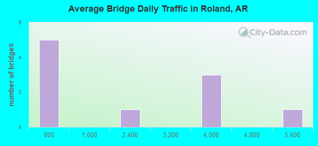
- 17,643Total average daily traffic
- 175Total average daily truck traffic
- 24,578Total future (year 2004) average daily traffic
- National Bridge Inventory (NBI) Registered Bridges for Roland
- No street view available for this location
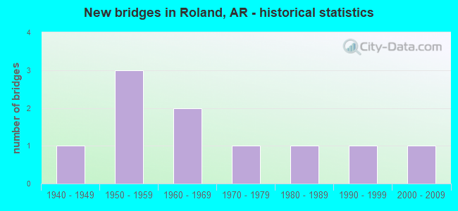
- New bridges - historical statistics
- 11940-1949
- 31950-1959
- 21960-1969
- 11970-1979
- 11980-1989
- 11990-1999
- 12000-2009
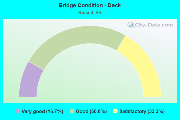
- Bridge Condition - Deck
- 16.7%Very good
- 50.0%Good
- 33.3%Satisfactory
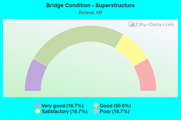
- Bridge Condition - Superstructure
- 16.7%Very good
- 50.0%Good
- 16.7%Satisfactory
- 16.7%Poor
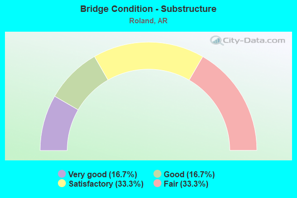
- Bridge Condition - Substructure
- 16.7%Very good
- 16.7%Good
- 33.3%Satisfactory
- 33.3%Fair
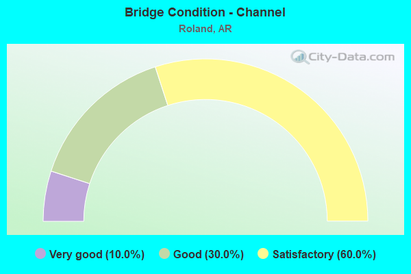
- Bridge Condition - Channel
- 10.0%Very good
- 30.0%Good
- 60.0%Satisfactory
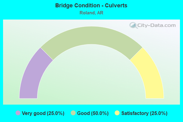
- Bridge Condition - Culverts
- 25.0%Very good
- 50.0%Good
- 25.0%Satisfactory
Find on map >> Show street view
Structure Number: 1726, Location: .01 MI S FAUL CO I-F (Lat: 34.904019, Lng: -92.447961), Route carried "on" structure: State highway 365, Year Built: 1955, Status: Open, Structure Length: 5.21m (17.09ft), Average Daily Traffic: 5,000 (year 2014), Truck Traffic: 1%, Average Future Daily Traffic: 6,481 (year 2028), Design Load: H 20, Features Intersected: PALARM CREEK
Minimum Vertical Clearance: 30+ m (98+ ft), Kilometerpoint: 0.002, Lanes on structure: 2, Owner: State Highway Agency, Approaching Roadway Width: 88.0m (288.7ft), Material/Design: Steel, Design/Construction: Stringer/Multi-beam, Number Of Spans In Main Unit: 3, Number Of Approach Spans: 2, Length of Maximum Span: 18.9m (62.0ft), Curb or Sidewalk Widths: Left: 0.5m (1.6ft), Right: 0.5m (1.6ft), Curb-To-Curb Width: 7.9m (25.9ft), Out-to-Out Width: 9.6m (31.5ft)
Condition: Deck: Satisfactory, Superstructure: Poor, Substructure: Fair, Channel: Satisfactory, Operating Rating: 39.9 metric tons, Method Used To Determine Operating Rating: Load Factor (LF), Inventory Rating: 23.6 metric tons, Method Used To Determine Inventory Rating: Load Factor (LF), Structural Evaluation: Meets minimum limits, Deck Geometry: High priority of corrective action, Waterway Adequacy: Equal to present desirable criteria, Approach Roadway Alignment: Equal to present minimum criteria, Length Of Structure Improvement: 61.60m (202.10ft), Designated Inspection Frequency: Every 24 months, Other Special Inspection Frequency: Every 24 months, Inspection Date: October 2017, Other Special Inspection Date: October 2016, Roadway Improvement Cost: $125,000, Total Project Cost: $489,000, Deck Structure Type: Concrete Cast-file-Place, Wearing Surface/Protective System: Wearing Surface: Bituminous
Find on map >> Show street view
Structure Number: 5811, Location: 7.5 MI NO SH 10 JCT (Lat: 34.896289, Lng: -92.502389), Route carried "on" structure: State highway 300, Year Built: 1981, Status: Open, Structure Length: 4.27m (14.01ft), Average Daily Traffic: 2,000 (year 2014), Truck Traffic: 1%, Average Future Daily Traffic: 2,722 (year 2028), Design Load: HS 20, Features Intersected: MILL BAYOU
Minimum Vertical Clearance: 30+ m (98+ ft), Kilometerpoint: 20.595, Lanes on structure: 2, Owner: State Highway Agency, Approaching Roadway Width: 122.0m (400.3ft), Material/Design: Concrete, Design/Construction: Slab, Number Of Spans In Main Unit: 4, Length of Maximum Span: 10.7m (35.1ft), Curb-To-Curb Width: 9.8m (32.2ft), Out-to-Out Width: 10.7m (35.1ft)
Condition: Deck: Very good, Superstructure: Very good, Substructure: Very good, Channel: Good, Operating Rating: 54.4 metric tons, Method Used To Determine Operating Rating: Load Factor (LF), Inventory Rating: 32.7 metric tons, Method Used To Determine Inventory Rating: Load Factor (LF), Structural Evaluation: Equal to present desirable criteria, Deck Geometry: Somewhat better than minimum adequacy, Waterway Adequacy: Equal to present desirable criteria, Approach Roadway Alignment: Equal to present desirable criteria, Designated Inspection Frequency: Every 24 months, Inspection Date: Febuary 2016, Deck Structure Type: Concrete Cast-file-Place, Wearing Surface/Protective System: Wearing Surface: Monolithic Concrete
Find on map >> Show street view
Structure Number: 16544, Location: 4.05 MI N SH 300 (Lat: 34.941989, Lng: -92.538061), Route carried "on" structure: County highway 408, Year Built: 1969, Status: Open, Structure Length: 0.94m (3.08ft), Average Daily Traffic: 55 (year 1987), Truck Traffic: 1%, Average Future Daily Traffic: 71 (year 2007), Features Intersected: CREEK
Minimum Vertical Clearance: 30+ m (98+ ft), Kilometerpoint: 6.515, Lanes on structure: 2, Owner: County Highway Agency, Approaching Roadway Width: 67.0m (219.8ft), Material/Design: Concrete, Design/Construction: Channel Beam, Number Of Spans In Main Unit: 1, Length of Maximum Span: 8.8m (28.9ft), Curb or Sidewalk Widths: Left: 0.3m (1.0ft), Right: 0.3m (1.0ft), Curb-To-Curb Width: 7.3m (24.0ft), Out-to-Out Width: 7.8m (25.6ft)
Condition: Deck: Good, Superstructure: Good, Substructure: Good, Channel: Good, Operating Rating: 45.4 metric tons, Method Used To Determine Operating Rating: Load Factor (LF), Inventory Rating: 27.2 metric tons, Method Used To Determine Inventory Rating: Load Factor (LF), Structural Evaluation: Equal to present minimum criteria, Deck Geometry: Equal to present minimum criteria, Waterway Adequacy: Equal to present desirable criteria, Approach Roadway Alignment: Equal to present minimum criteria, Designated Inspection Frequency: Every 24 months, Inspection Date: October 2016, Deck Structure Type: Concrete Cast-file-Place, Wearing Surface/Protective System: Wearing Surface: Bituminous
Find on map >> Show street view
Structure Number: 21275, Location: 1.0 M W OF SH 300 (Lat: 34.902597, Lng: -92.508508), Route carried "on" structure: County highway 415, Year Built: 1970, Status: Open, Structure Length: 0.94m (3.08ft), Average Daily Traffic: 55 (year 1987), Truck Traffic: 1%, Average Future Daily Traffic: 71 (year 2007), Features Intersected: MILL BAYOU
Minimum Vertical Clearance: 30+ m (98+ ft), Kilometerpoint: 1.609, Lanes on structure: 2, Owner: County Highway Agency, Approaching Roadway Width: 73.0m (239.5ft), Material/Design: Concrete, Design/Construction: Channel Beam, Number Of Spans In Main Unit: 1, Length of Maximum Span: 9.1m (29.9ft), Curb or Sidewalk Widths: Left: 0.3m (1.0ft), Right: 0.3m (1.0ft), Curb-To-Curb Width: 7.4m (24.3ft), Out-to-Out Width: 0.8m (2.6ft)
Condition: Deck: Good, Superstructure: Good, Substructure: Satisfactory, Channel: Satisfactory, Operating Rating: 54.4 metric tons, Method Used To Determine Operating Rating: Load Factor (LF), Inventory Rating: 32.7 metric tons, Method Used To Determine Inventory Rating: Load Factor (LF), Structural Evaluation: Equal to present minimum criteria, Deck Geometry: Equal to present minimum criteria, Waterway Adequacy: Equal to present desirable criteria, Approach Roadway Alignment: Equal to present minimum criteria, Designated Inspection Frequency: Every 24 months, Inspection Date: January 2016, Deck Structure Type: Concrete Precast Panels, Wearing Surface/Protective System: Wearing Surface: Bituminous
Find on map >> Show street view
Structure Number: 21369, Location: .2 MI SO OF S H 300 (Lat: 34.935033, Lng: -92.602211), Route carried "on" structure: County highway 401, Year Built: 1993, Status: Open, Structure Length: 0.67m (2.20ft), Average Daily Traffic: 23 (year 1984), Truck Traffic: 1%, Average Future Daily Traffic: 30 (year 2004), Features Intersected: CREEK
Minimum Vertical Clearance: 30+ m (98+ ft), Kilometerpoint: 0.322, Lanes on structure: 2, Owner: County Highway Agency, Approaching Roadway Width: 49.0m (160.8ft), Material/Design: Steel, Design/Construction: Culvert, Number Of Spans In Main Unit: 4, Length of Maximum Span: 1.5m (4.9ft)
Condition: Channel: Satisfactory, Culverts: Good, Operating Rating: 54.4 metric tons, Method Used To Determine Operating Rating: Load Factor (LF), Inventory Rating: 32.7 metric tons, Method Used To Determine Inventory Rating: Load Factor (LF), Structural Evaluation: Better than present minimum criteria, Waterway Adequacy: Better than present minimum criteria, Approach Roadway Alignment: Better than present minimum criteria, Designated Inspection Frequency: Every 24 months, Inspection Date: October 2017
Find on map >> Show street view
Structure Number: 22309, Location: 2.9 M W of SH 300 (Lat: 34.908511, Lng: -92.539531), Route carried "on" structure: County highway 415, Year Built: 2001, Status: Open, Structure Length: 0.84m (2.76ft), Average Daily Traffic: 400 (year 2001), Truck Traffic: 1%, Average Future Daily Traffic: 518 (year 2021), Features Intersected: Creek, Facility Carried by Structure: Roland Cut-off
Minimum Vertical Clearance: 30+ m (98+ ft), Kilometerpoint: 4.666, Lanes on structure: 2, Owner: County Highway Agency, Approaching Roadway Width: 61.0m (200.1ft), Material/Design: Steel, Design/Construction: Culvert, Number Of Spans In Main Unit: 1, Length of Maximum Span: 1.8m (5.9ft), Curb-To-Curb Width: 6.1m (20.0ft), Out-to-Out Width: 6.1m (20.0ft)
Condition: Channel: Satisfactory, Culverts: Very good, Operating Rating: 54.4 metric tons, Method Used To Determine Operating Rating: Load Factor (LF), Inventory Rating: 32.7 metric tons, Method Used To Determine Inventory Rating: Load Factor (LF), Structural Evaluation: Equal to present desirable criteria, Deck Geometry: Meets minimum limits, Waterway Adequacy: Equal to present minimum criteria, Approach Roadway Alignment: Equal to present desirable criteria, Designated Inspection Frequency: Every 24 months, Inspection Date: November 2016
Find on map >> Show street view
Structure Number: M0325, Location: 8.35 MI WEST OF SH 300 (Lat: 34.875039, Lng: -92.609781), Route carried "on" structure: State highway 10, Year Built: 1958, Status: Open, Structure Length: 0.07m (0.23ft), Average Daily Traffic: 3,200 (year 2014), Truck Traffic: 1%, Average Future Daily Traffic: 4,666 (year 2028), Design Load: H 20, Features Intersected: TWIN CREEK
Minimum Vertical Clearance: 30+ m (98+ ft), Kilometerpoint: 15.105, Lanes on structure: 2, Base Highway Network: Yes, Owner: State Highway Agency, Approaching Roadway Width: 82.0m (269.0ft), Material/Design: Concrete, Design/Construction: Culvert, Number Of Spans In Main Unit: 2, Length of Maximum Span: 3.4m (11.2ft)
Condition: Channel: Satisfactory, Culverts: Good, Operating Rating: 54.4 metric tons, Method Used To Determine Operating Rating: Load Factor (LF), Inventory Rating: 32.7 metric tons, Method Used To Determine Inventory Rating: Load Factor (LF), Structural Evaluation: Better than present minimum criteria, Waterway Adequacy: Equal to present desirable criteria, Approach Roadway Alignment: Equal to present desirable criteria, Designated Inspection Frequency: Every 24 months, Inspection Date: December 2016
Find on map >> Show street view
Structure Number: M0326, Location: 6.93 MI W SH 300 (Lat: 34.868681, Lng: -92.586139), Route carried "on" structure: State highway 10, Year Built: 1958, Status: Open, Structure Length: 2.07m (6.79ft), Average Daily Traffic: 3,200 (year 2014), Truck Traffic: 1%, Average Future Daily Traffic: 4,666 (year 2028), Design Load: H 20, Features Intersected: WORTHEN CREEK
Minimum Vertical Clearance: 30+ m (98+ ft), Kilometerpoint: 1.739, Lanes on structure: 2, Base Highway Network: Yes, Owner: State Highway Agency, Approaching Roadway Width: 1.1m (3.6ft), Material/Design: Steel, Design/Construction: Stringer/Multi-beam, Number Of Spans In Main Unit: 2, Length of Maximum Span: 10.4m (34.1ft), Curb or Sidewalk Widths: Left: 0.6m (2.0ft), Right: 0.6m (2.0ft), Curb-To-Curb Width: 7.9m (25.9ft), Out-to-Out Width: 9.1m (29.9ft)
Condition: Deck: Good, Superstructure: Good, Substructure: Satisfactory, Channel: Very good, Operating Rating: 3.9 metric tons, Method Used To Determine Operating Rating: Load Factor (LF), Inventory Rating: 23.6 metric tons, Method Used To Determine Inventory Rating: Load Factor (LF), Structural Evaluation: Equal to present minimum criteria, Deck Geometry: High priority of corrective action, Waterway Adequacy: Equal to present desirable criteria, Approach Roadway Alignment: Equal to present desirable criteria, Length Of Structure Improvement: 28.30m (92.85ft), Designated Inspection Frequency: Every 24 months, Inspection Date: October 2017, Roadway Improvement Cost: $156,000, Total Project Cost: $387,000, Deck Structure Type: Concrete Cast-file-Place, Wearing Surface/Protective System: Wearing Surface: Monolithic Concrete
Find on map >> Show street view
Structure Number: M0327, Location: 0.25 M W Jolly Roger Rd. (Lat: 34.863761, Lng: -92.570561), Route carried "on" structure: State highway 10, Year Built: 1947, Status: Open, Structure Length: 0.76m (2.49ft), Average Daily Traffic: 3,200 (year 2014), Truck Traffic: 1%, Average Future Daily Traffic: 4,666 (year 2028), Design Load: H 20, Features Intersected: BRANCH
Minimum Vertical Clearance: 30+ m (98+ ft), Kilometerpoint: 18.935, Lanes on structure: 2, Base Highway Network: Yes (Inventory Route: 100, Subroute: 10), Owner: State Highway Agency, Approaching Roadway Width: 174.0m (570.9ft), Material/Design: Concrete, Design/Construction: Culvert, Number Of Spans In Main Unit: 2, Length of Maximum Span: 3.7m (12.1ft), Curb-To-Curb Width: 17.4m (57.1ft), Out-to-Out Width: 17.7m (58.1ft)
Condition: Channel: Good, Culverts: Satisfactory, Operating Rating: 31.7 metric tons, Method Used To Determine Operating Rating: Load Factor (LF), Inventory Rating: 1.9 metric tons, Method Used To Determine Inventory Rating: Load Factor (LF), Structural Evaluation: Somewhat better than minimum adequacy, Deck Geometry: Superior to present desirable criteria, Waterway Adequacy: Equal to present desirable criteria, Approach Roadway Alignment: Equal to present desirable criteria, Designated Inspection Frequency: Every 24 months, Inspection Date: January 2018
Find on map >> Show street view
Structure Number: M2812, Location: 9.65 MI E OF SH 113 (Lat: 34.917231, Lng: -92.507419), Route carried "on" structure: State highway 300, Year Built: 1962, Status: Open, Structure Length: 1.28m (4.20ft), Average Daily Traffic: 510 (year 2014), Truck Traffic: 1%, Average Future Daily Traffic: 687 (year 2028), Features Intersected: CREEK
Minimum Vertical Clearance: 30+ m (98+ ft), Kilometerpoint: 15.527, Lanes on structure: 2, Owner: State Highway Agency, Approaching Roadway Width: 76.0m (249.3ft), Material/Design: Concrete, Design/Construction: Slab, Number Of Spans In Main Unit: 3, Length of Maximum Span: 4.3m (14.1ft), Curb or Sidewalk Widths: Left: 0.2m (0.7ft), Right: 0.2m (0.7ft), Curb-To-Curb Width: 7.3m (24.0ft), Out-to-Out Width: 7.7m (25.3ft)
Condition: Deck: Satisfactory, Superstructure: Satisfactory, Substructure: Fair, Channel: Satisfactory, Operating Rating: 33.6 metric tons, Method Used To Determine Operating Rating: Load Factor (LF), Inventory Rating: 2.0 metric tons, Method Used To Determine Inventory Rating: Load Factor (LF), Structural Evaluation: Somewhat better than minimum adequacy, Deck Geometry: Meets minimum limits, Waterway Adequacy: Equal to present minimum criteria, Approach Roadway Alignment: Better than present minimum criteria, Length Of Structure Improvement: 12.80m (41.99ft), Designated Inspection Frequency: Every 24 months, Inspection Date: November 2016, Total Project Cost: $47,000, Deck Structure Type: Concrete Cast-file-Place, Wearing Surface/Protective System: Wearing Surface: Monolithic Concrete