Bridge Statistics for Ronceverte, West Virginia (WV)
Condition, Traffic, Stress, Structural Evaluation, Project Costs
- National Bridge Inventory (NBI) Statistics
- 10Number of bridges
- 167ft / 50.7mTotal length
- $5,319,000Total costs
- 15,143Total average daily traffic
- 1,394Total average daily truck traffic
- National Bridge Inventory (NBI) Registered Bridges for Ronceverte
- No street view available for this location
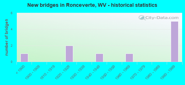
- New bridges - historical statistics
- 1Before 1900
- 21920-1929
- 11940-1949
- 11960-1969
- 51990-1999


- Bridge Condition - Deck
- 50.0%Good
- 33.3%Satisfactory
- 16.7%Fair

- Bridge Condition - Superstructure
- 16.7%Very good
- 50.0%Good
- 16.7%Satisfactory
- 16.7%Fair

- Bridge Condition - Substructure
- 50.0%Good
- 50.0%Fair

- Bridge Condition - Channel
- 16.7%Very good
- 50.0%Good
- 33.3%Satisfactory
Find on map >> Show street view
Structure Number: 13A095, Location: 0.01 Miles N. of CR 43/1 (Lat: 37.744081, Lng: -80.545881), Route carried "on" structure: County highway 4300, Year Built: 1925, Year Reconstructed: 1997, Status: Posted for load, Structure Length: 7.71m (25.30ft), Average Daily Traffic: 677 (year 2019), Truck Traffic: 10%, Average Future Daily Traffic: 879 (year 2039), Design Load: HS 15, Features Intersected: GREENBRIER RIVER, Facility Carried by Structure: COUNTY ROUTE 43
Minimum Vertical Clearance: 4.57m (14.99ft), Kilometerpoint: 6.550, Lanes on structure: 2, Owner: State Highway Agency, Approaching Roadway Width: 6.7m (22.0ft), Material/Design: Steel, Design/Construction: Truss - Thru, Number Of Spans In Main Unit: 1, Number Of Approach Spans: 2, Length of Maximum Span: 51.5m (169.0ft), Curb-To-Curb Width: 6.0m (19.7ft), Out-to-Out Width: 6.5m (21.3ft)
Condition: Deck: Good, Superstructure: Fair, Substructure: Fair, Channel: Good, Operating Rating: 46.3 metric tons, Method Used To Determine Operating Rating: Load Factor (LF), Inventory Rating: 28.1 metric tons, Method Used To Determine Inventory Rating: Load Factor (LF), Structural Evaluation: Somewhat better than minimum adequacy, Deck Geometry: High priority of replacement, Waterway Adequacy: Somewhat better than minimum adequacy, Approach Roadway Alignment: Equal to present minimum criteria, Length Of Structure Improvement: 8.72m (28.61ft), Designated Inspection Frequency: Every 24 months, Critical Feature Inspection Frequency: Every 24 months, Inspection Date: October 2020, Critical Feature Inspection Date: October 2020, Bridge Improvement Cost: $1,165,000, Roadway Improvement Cost: $711,000, Total Project Cost: $1,876,000 ( Estimate for 2020), Deck Structure Type: Open Grating, Wearing Surface/Protective System: Wearing Surface: Other, Deck Protection: Galvanized Reinforcing
Find on map >> Show street view
Structure Number: 13A14, Location: 0.81 Miles N. of CR 62 (Lat: 37.714219, Lng: -80.523600), Route carried "on" structure: County highway 6201, Year Built: 1923, Status: Posted for load, Structure Length: 3.27m (10.73ft), Average Daily Traffic: 55 (year 2019), Truck Traffic: 10%, Average Future Daily Traffic: 70 (year 2039), Features Intersected: SECOND CREEK, Facility Carried by Structure: COUNTY ROUTE 62/1
Minimum Vertical Clearance: 30+ m (98+ ft), Kilometerpoint: 1.304, Lanes on structure: 1, Owner: State Highway Agency, Approaching Roadway Width: 4.3m (14.1ft), Material/Design: Concrete continuous, Design/Construction: Arch - Deck, Number Of Spans In Main Unit: 1, Number Of Approach Spans: 2, Length of Maximum Span: 16.1m (52.8ft), Curb-To-Curb Width: 4.6m (15.1ft), Out-to-Out Width: 5.4m (17.7ft)
Condition: Deck: Fair, Superstructure: Satisfactory, Substructure: Fair, Channel: Satisfactory, Operating Rating: 41.7 metric tons, Method Used To Determine Operating Rating: Field evaluation and documented engineering judgment, Inventory Rating: 17.2 metric tons, Method Used To Determine Inventory Rating: Field evaluation and documented engineering judgment, Structural Evaluation: Somewhat better than minimum adequacy, Deck Geometry: Better than present minimum criteria, Waterway Adequacy: Equal to present desirable criteria, Approach Roadway Alignment: Meets minimum limits, Length Of Structure Improvement: 4.27m (14.01ft), Designated Inspection Frequency: Every 24 months, Inspection Date: July 2020, Bridge Improvement Cost: $658,000, Roadway Improvement Cost: $398,000, Total Project Cost: $1,056,000 ( Estimate for 2020), Deck Structure Type: Concrete Cast-file-Place, Wearing Surface/Protective System: Wearing Surface: Bituminous
Find on map >> Show street view
Structure Number: 13A141, Location: 0.06 Miles W. of CR 43 (Lat: 37.753431, Lng: -80.546669), Route carried "on" structure: State highway 6300, Year Built: 1947, Status: Open, Structure Length: 1.12m (3.67ft), Average Daily Traffic: 2,370 (year 2019), Truck Traffic: 14%, Average Future Daily Traffic: 3,034 (year 2039), Features Intersected: MILLIGAN CREEK, Facility Carried by Structure: WV 63
Minimum Vertical Clearance: 30+ m (98+ ft), Kilometerpoint: 9.656, Lanes on structure: 2, Owner: State Highway Agency, Approaching Roadway Width: 7.3m (24.0ft), Skew: 4 degrees, Material/Design: Concrete continuous, Design/Construction: Culvert, Number Of Spans In Main Unit: 3, Length of Maximum Span: 3.4m (11.2ft)
Condition: Channel: Good, Culverts: Fair, Operating Rating: 88.9 metric tons, Method Used To Determine Operating Rating: Field evaluation and documented engineering judgment, Inventory Rating: 40.8 metric tons, Method Used To Determine Inventory Rating: Field evaluation and documented engineering judgment, Structural Evaluation: Somewhat better than minimum adequacy, Waterway Adequacy: Equal to present desirable criteria, Approach Roadway Alignment: Better than present minimum criteria, Designated Inspection Frequency: Every 24 months, Inspection Date: April 2020
Find on map >> Show street view
Structure Number: 13A18, Location: 0.05 Miles N. of CR 48 (Lat: 37.744431, Lng: -80.468289), Route carried "on" structure: US 21900, Year Built: 1995, Status: Open, Structure Length: 12.96m (42.52ft), Average Daily Traffic: 5,500 (year 2019), Truck Traffic: 8%, Average Future Daily Traffic: 7,290 (year 2039), Design Load: HS 25 or greater, Features Intersected: GREENBRIER RIVER, Facility Carried by Structure: US 219
Minimum Vertical Clearance: 30+ m (98+ ft), Kilometerpoint: 10.364, Lanes on structure: 2, Base Highway Network: Yes, Owner: State Highway Agency, Approaching Roadway Width: 9.1m (29.9ft), Skew: 3 degrees, Material/Design: Steel continuous, Design/Construction: Stringer/Multi-beam, Number Of Spans In Main Unit: 3, Length of Maximum Span: 42.7m (140.1ft), Curb or Sidewalk Widths: Left: 0.0m, Right: 1.5m (4.9ft), Curb-To-Curb Width: 9.1m (29.9ft), Out-to-Out Width: 11.5m (37.7ft)
Condition: Deck: Satisfactory, Superstructure: Good, Substructure: Good, Channel: Good, Operating Rating: 88.9 metric tons, Method Used To Determine Operating Rating: Load Factor (LF), Inventory Rating: 58.0 metric tons, Method Used To Determine Inventory Rating: Load Factor (LF), Structural Evaluation: Better than present minimum criteria, Deck Geometry: Meets minimum limits, Waterway Adequacy: Equal to present desirable criteria, Approach Roadway Alignment: Equal to present minimum criteria, Designated Inspection Frequency: Every 24 months, Inspection Date: April 2020, Deck Structure Type: Concrete Cast-file-Place, Wearing Surface/Protective System: Wearing Surface: Monolithic Concrete, Deck Protection: Epoxy Coated Reinforcing
Find on map >> Show street view
Structure Number: 13A181, Location: 0.15 Miles N. of CR 48 (Lat: 37.745961, Lng: -80.469369), Route carried "on" structure: US 21900, Year Built: 1995, Status: Open, Structure Length: 18.43m (60.47ft), Average Daily Traffic: 5,748 (year 2019), Truck Traffic: 8%, Average Future Daily Traffic: 7,357 (year 2039), Design Load: HS 25 or greater, Features Intersected: MONROE, EDGAR AVE CSX RR, Facility Carried by Structure: US 219
Minimum Vertical Clearance: 30+ m (98+ ft), Kilometerpoint: 10.525, Lanes on structure: 2, Lanes under structure: 3, Base Highway Network: Yes, Owner: State Highway Agency, Approaching Roadway Width: 9.1m (29.9ft), Material/Design: Steel continuous, Design/Construction: Stringer/Multi-beam, Number Of Spans In Main Unit: 5, Length of Maximum Span: 36.6m (120.1ft), Curb or Sidewalk Widths: Left: 1.5m (4.9ft), Right: 1.5m (4.9ft), Curb-To-Curb Width: 9.1m (29.9ft), Out-to-Out Width: 12.8m (42.0ft)
Condition: Deck: Satisfactory, Superstructure: Good, Substructure: Good, Operating Rating: 72.6 metric tons, Method Used To Determine Operating Rating: Load Factor (LF), Inventory Rating: 43.5 metric tons, Method Used To Determine Inventory Rating: Load Factor (LF), Structural Evaluation: Better than present minimum criteria, Deck Geometry: Meets minimum limits, Underclear: High priority of corrective action, Approach Roadway Alignment: Equal to present minimum criteria, Length Of Structure Improvement: 18.44m (60.50ft), Designated Inspection Frequency: Every 24 months, Inspection Date: July 2020, Bridge Improvement Cost: $931,000, Roadway Improvement Cost: $633,000, Total Project Cost: $1,721,000 ( Estimate for 2020), Deck Structure Type: Concrete Cast-file-Place, Wearing Surface/Protective System: Wearing Surface: Monolithic Concrete, Deck Protection: Epoxy Coated Reinforcing
Find on map >> Show street view
Structure Number: 13A206, Location: 0.20 Miles W. of CR 43/3 (Lat: 37.697361, Lng: -80.525281), Route carried "on" structure: County highway 6200, Year Built: 1991, Status: Open, Structure Length: 4.74m (15.55ft), Average Daily Traffic: 443 (year 2019), Truck Traffic: 10%, Average Future Daily Traffic: 567 (year 2039), Design Load: HS 25 or greater, Features Intersected: SECOND CREEK, Facility Carried by Structure: COUNTY ROUTE 62
Minimum Vertical Clearance: 30+ m (98+ ft), Kilometerpoint: 0.225, Lanes on structure: 2, Owner: State Highway Agency, Approaching Roadway Width: 7.6m (24.9ft), Skew: 2 degrees, Material/Design: Steel continuous, Design/Construction: Stringer/Multi-beam, Number Of Spans In Main Unit: 2, Length of Maximum Span: 22.9m (75.1ft), Curb-To-Curb Width: 6.7m (22.0ft), Out-to-Out Width: 7.8m (25.6ft)
Condition: Deck: Good, Superstructure: Very good, Substructure: Good, Channel: Very good, Operating Rating: 79.8 metric tons, Method Used To Determine Operating Rating: Load Factor (LF), Inventory Rating: 48.1 metric tons, Method Used To Determine Inventory Rating: Load Factor (LF), Structural Evaluation: Better than present minimum criteria, Deck Geometry: Meets minimum limits, Waterway Adequacy: Superior to present desirable criteria, Approach Roadway Alignment: Equal to present desirable criteria, Designated Inspection Frequency: Every 48 months, Inspection Date: August 2020, Deck Structure Type: Concrete Cast-file-Place, Wearing Surface/Protective System: Wearing Surface: Monolithic Concrete, Deck Protection: Epoxy Coated Reinforcing
Find on map >> Show street view
Structure Number: 32A014, Location: 0.26 Miles N. of CR 5/1 (Lat: 37.690131, Lng: -80.508219), Route carried "on" structure: County highway 504, Year Built: 1962, Status: Posted for load, Structure Length: 2.51m (8.23ft), Average Daily Traffic: 50 (year 2019), Truck Traffic: 8%, Average Future Daily Traffic: 61 (year 2039), Features Intersected: SECOND CREEK, Facility Carried by Structure: COUNTY ROUTE 5/4
Minimum Vertical Clearance: 30+ m (98+ ft), Kilometerpoint: 0.418, Lanes on structure: 1, Owner: State Highway Agency, Approaching Roadway Width: 4.6m (15.1ft), Material/Design: Steel, Design/Construction: Girder and Floorbeam System, Number Of Spans In Main Unit: 2, Length of Maximum Span: 11.8m (38.7ft), Curb-To-Curb Width: 4.1m (13.5ft), Out-to-Out Width: 4.3m (14.1ft)
Condition: Deck: Good, Superstructure: Good, Substructure: Fair, Channel: Satisfactory, Operating Rating: 37.2 metric tons, Method Used To Determine Operating Rating: Load Factor (LF), Inventory Rating: 22.7 metric tons, Method Used To Determine Inventory Rating: Load Factor (LF), Structural Evaluation: Somewhat better than minimum adequacy, Deck Geometry: Somewhat better than minimum adequacy, Waterway Adequacy: Equal to present desirable criteria, Approach Roadway Alignment: High priority of corrective action, Length Of Structure Improvement: 3.35m (10.99ft), Designated Inspection Frequency: Every 24 months, Critical Feature Inspection Frequency: Every 24 months, Inspection Date: Febuary 2021, Critical Feature Inspection Date: Febuary 2021, Bridge Improvement Cost: $409,000, Roadway Improvement Cost: $257,000, Total Project Cost: $666,000 ( Estimate for 2021), Deck Structure Type: Wood or Timber, Wearing Surface/Protective System: Deck Protection: Other
Find on map >> Show street view
Structure Number: 13A139, Location: 0.04 Miles N. of CR 62 (Lat: 37.697281, Lng: -80.524839), Route carried "under" structure: County highway 625, Year Built: 1899, Structure Length: 0. m, Features Intersected: Second Creek, Facility Carried by Structure: COUNTY ROUTE 62/5
Minimum Vertical Clearance: 2.82m (9.25ft), Kilometerpoint: 0.064, Material/Design: Wood or Timber, Design/Construction: Truss - Thru, Length of Maximum Span: 24.5m (80.4ft)
Find on map >> Show street view
Structure Number: 13A181, Location: 0.15 Miles N. of CR 48 (Lat: 37.746514, Lng: -80.469736), Route carried "under" structure: City street , Year Built: 1995, Structure Length: 0. m, Average Daily Traffic: 150 (year 0011), Truck Traffic: 15%, Features Intersected: MONROE, EDGAR AVE CSX RR, Facility Carried by Structure: US 219
Minimum Vertical Clearance: 4.70m (15.42ft), Kilometerpoint: 0.000, Lanes on structure: 2, Lanes under structure: 1, Length of Maximum Span: 36.6m (120.1ft)
Find on map >> Show street view
Structure Number: 13A181, Location: 0.15 Miles N. of CR 48 (Lat: 37.745469, Lng: -80.469044), Route carried "under" structure: City street , Year Built: 1995, Structure Length: 0. m, Average Daily Traffic: 150 (year 0011), Truck Traffic: 15%, Features Intersected: MONROE, EDGAR AVE CSX RR, Facility Carried by Structure: US 219
Minimum Vertical Clearance: 3.76m (12.34ft), Kilometerpoint: 0.000, Lanes on structure: 2, Lanes under structure: 2, Length of Maximum Span: 36.6m (120.1ft)