Bridge Statistics for Roosevelt, Arizona (AZ)
Condition, Traffic, Stress, Structural Evaluation, Project Costs
- National Bridge Inventory (NBI) Statistics
- 13Number of bridges
- 673ft / 205mTotal length
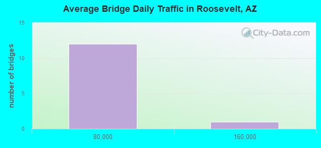
- 166,354Total average daily traffic
- 11,975Total average daily truck traffic
- 134,898Total future (year 2037) average daily traffic
- National Bridge Inventory (NBI) Registered Bridges for Roosevelt
- No street view available for this location
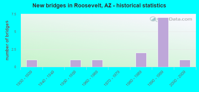
- New bridges - historical statistics
- 11930-1939
- 11950-1959
- 11960-1969
- 21980-1989
- 71990-1999
- 12000-2009
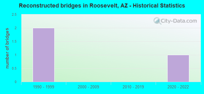
- Reconstructed bridges - Historical Statistics
- 21990-1999
- 02000-2009
- 02010-2019
- 12020-2022
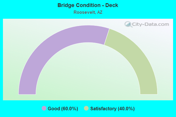
- Bridge Condition - Deck
- 60.0%Good
- 40.0%Satisfactory
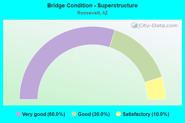
- Bridge Condition - Superstructure
- 60.0%Very good
- 30.0%Good
- 10.0%Satisfactory
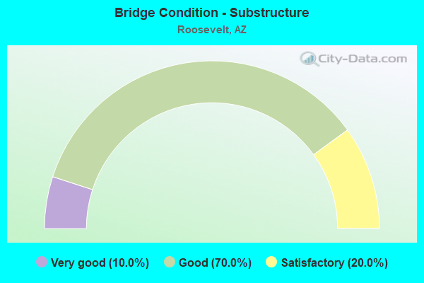
- Bridge Condition - Substructure
- 10.0%Very good
- 70.0%Good
- 20.0%Satisfactory
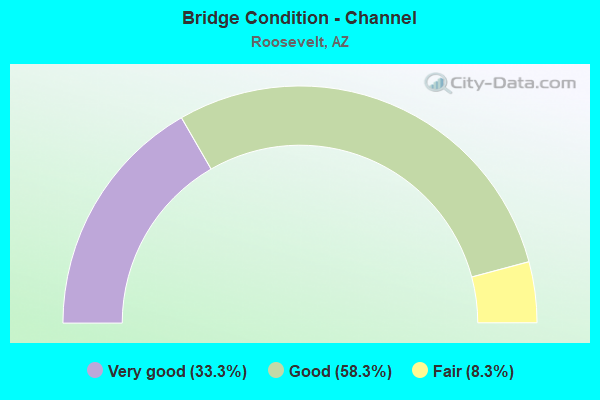
- Bridge Condition - Channel
- 33.3%Very good
- 58.3%Good
- 8.3%Fair
Find on map >> Show street view
Structure Number: 219, Location: 16.2 mi E Jct SR 191 (Lat: 32.778100, Lng: -109.295200), Route carried "on" structure: US 70, Year Built: 1938, Status: Open, Structure Length: 2.32m (7.61ft), Average Daily Traffic: 1,152 (year 2018), Truck Traffic: 10%, Average Future Daily Traffic: 1,162 (year 2038), Design Load: H 15, Features Intersected: Slick Rock Wash
Minimum Vertical Clearance: 30+ m (98+ ft), Kilometerpoint: 588.537, Lanes on structure: 2, Owner: State Highway Agency, Approaching Roadway Width: 11.6m (38.1ft), Skew: 3 degrees, Material/Design: Concrete continuous, Design/Construction: Slab, Number Of Spans In Main Unit: 3, Length of Maximum Span: 7.6m (24.9ft), Curb-To-Curb Width: 10.4m (34.1ft), Out-to-Out Width: 11.3m (37.1ft)
Condition: Deck: Satisfactory, Superstructure: Satisfactory, Substructure: Satisfactory, Channel: Good, Operating Rating: 38.1 metric tons, Method Used To Determine Operating Rating: Load Factor (LF), Inventory Rating: 22.7 metric tons, Method Used To Determine Inventory Rating: Load Factor (LF), Structural Evaluation: Equal to present minimum criteria, Deck Geometry: Equal to present minimum criteria, Waterway Adequacy: Equal to present desirable criteria, Approach Roadway Alignment: Equal to present desirable criteria, Designated Inspection Frequency: Every 24 months, Inspection Date: August 2021, Deck Structure Type: Concrete Cast-file-Place, Wearing Surface/Protective System: Wearing Surface: Bituminous
Find on map >> Show street view
Structure Number: 1443, Location: 47.1 mi E of Jct US 60 (Lat: 33.674381, Lng: -111.147758), Route carried "on" structure: State highway 188, Year Built: 1990, Status: Open, Structure Length: 18.75m (61.52ft), Average Daily Traffic: 696 (year 2018), Truck Traffic: 11%, Average Future Daily Traffic: 706 (year 2038), Design Load: HS 20, Features Intersected: Roosevelt Lake
Minimum Vertical Clearance: 30+ m (98+ ft), Kilometerpoint: 392.358, Lanes on structure: 2, Owner: State Highway Agency, Approaching Roadway Width: 10.4m (34.1ft), Material/Design: Prestressed concrete continuous, Design/Construction: Stringer/Multi-beam, Number Of Spans In Main Unit: 5, Length of Maximum Span: 37.2m (122.0ft), Curb-To-Curb Width: 11.6m (38.1ft), Out-to-Out Width: 12.6m (41.3ft)
Condition: Deck: Satisfactory, Superstructure: Very good, Substructure: Very good, Channel: Good, Operating Rating: 64.4 metric tons, Method Used To Determine Operating Rating: Load Factor (LF), Inventory Rating: 41.7 metric tons, Method Used To Determine Inventory Rating: Load Factor (LF), Structural Evaluation: Equal to present desirable criteria, Deck Geometry: Better than present minimum criteria, Waterway Adequacy: Equal to present desirable criteria, Approach Roadway Alignment: Equal to present desirable criteria, Designated Inspection Frequency: Every 24 months, Inspection Date: March 2020, Deck Structure Type: Concrete Cast-file-Place, Wearing Surface/Protective System: Wearing Surface: Monolithic Concrete
Find on map >> Show street view
Structure Number: 1444, Location: 47.51 mi E of Jct US 60 (Lat: 33.669500, Lng: -111.142600), Route carried "on" structure: State highway 188, Year Built: 1990, Status: Open, Structure Length: 24.08m (79.00ft), Average Daily Traffic: 696 (year 2018), Truck Traffic: 11%, Average Future Daily Traffic: 706 (year 2038), Design Load: HS 20, Features Intersected: Roosevelt Lake
Minimum Vertical Clearance: 30+ m (98+ ft), Kilometerpoint: 391.730, Lanes on structure: 2, Owner: State Highway Agency, Approaching Roadway Width: 10.4m (34.1ft), Material/Design: Prestressed concrete continuous, Design/Construction: Stringer/Multi-beam, Number Of Spans In Main Unit: 7, Length of Maximum Span: 34.1m (111.9ft), Curb-To-Curb Width: 12.2m (40.0ft), Out-to-Out Width: 13.2m (43.3ft)
Condition: Deck: Good, Superstructure: Good, Substructure: Satisfactory, Channel: Very good, Operating Rating: 68.9 metric tons, Method Used To Determine Operating Rating: Load Factor (LF), Inventory Rating: 41.7 metric tons, Method Used To Determine Inventory Rating: Load Factor (LF), Structural Evaluation: Equal to present minimum criteria, Deck Geometry: Equal to present desirable criteria, Waterway Adequacy: Equal to present desirable criteria, Approach Roadway Alignment: Equal to present minimum criteria, Designated Inspection Frequency: Every 24 months, Inspection Date: March 2020, Deck Structure Type: Concrete Cast-file-Place, Wearing Surface/Protective System: Wearing Surface: Monolithic Concrete
Find on map >> Show street view
Structure Number: 1445, Location: 48.26 mi E of Jct US 60 (Lat: 33.666906, Lng: -111.130911), Route carried "on" structure: State highway 188, Year Built: 1990, Status: Open, Structure Length: 19.20m (62.99ft), Average Daily Traffic: 696 (year 2018), Truck Traffic: 11%, Average Future Daily Traffic: 706 (year 2038), Design Load: HS 20, Features Intersected: Roosevelt Lake
Minimum Vertical Clearance: 30+ m (98+ ft), Kilometerpoint: 390.266, Lanes on structure: 2, Owner: State Highway Agency, Approaching Roadway Width: 10.4m (34.1ft), Material/Design: Prestressed concrete continuous, Design/Construction: Stringer/Multi-beam, Number Of Spans In Main Unit: 5, Length of Maximum Span: 38.1m (125.0ft), Curb-To-Curb Width: 11.6m (38.1ft), Out-to-Out Width: 12.6m (41.3ft)
Condition: Deck: Satisfactory, Superstructure: Very good, Substructure: Good, Channel: Very good, Operating Rating: 89.8 metric tons, Method Used To Determine Operating Rating: Load Factor (LF), Inventory Rating: 32.7 metric tons, Method Used To Determine Inventory Rating: Load Factor (LF), Structural Evaluation: Better than present minimum criteria, Deck Geometry: Better than present minimum criteria, Waterway Adequacy: Equal to present desirable criteria, Approach Roadway Alignment: Equal to present desirable criteria, Designated Inspection Frequency: Every 24 months, Inspection Date: March 2020, Deck Structure Type: Concrete Cast-file-Place, Wearing Surface/Protective System: Wearing Surface: Monolithic Concrete
Find on map >> Show street view
Structure Number: 1457, Location: 4.5 mi E Jct SR 51 (Lat: 33.658300, Lng: -111.925700), Route carried "on" structure: State highway 101, Year Built: 2001, Year Reconstructed: 2020, Status: Open, Structure Length: 7.19m (23.59ft), Average Daily Traffic: 157,576 (year 2017), Truck Traffic: 7%, Average Future Daily Traffic: 126,000 (year 2037), Design Load: HS 20, Features Intersected: Scottsdale Road
Minimum Vertical Clearance: 30+ m (98+ ft), Kilometerpoint: 55.555, Lanes on structure: 10, Lanes under structure: 10, Owner: State Highway Agency, Approaching Roadway Width: 41.5m (136.2ft), Skew: 31 degrees, Material/Design: Prestressed concrete continuous, Design/Construction: Box Beam or Girders - Single/Spread, Number Of Spans In Main Unit: 2, Length of Maximum Span: 35.1m (115.2ft), Curb-To-Curb Width: 49.7m (163.1ft), Out-to-Out Width: 51.5m (169.0ft)
Condition: Deck: Good, Superstructure: Good, Substructure: Good, Operating Rating: 89.8 metric tons, Method Used To Determine Operating Rating: Load Factor (LF), Inventory Rating: 49.9 metric tons, Method Used To Determine Inventory Rating: Load Factor (LF), Structural Evaluation: Better than present minimum criteria, Deck Geometry: Superior to present desirable criteria, Underclear: Equal to present minimum criteria, Approach Roadway Alignment: Equal to present desirable criteria, Designated Inspection Frequency: Every 24 months, Inspection Date: October 2020, Deck Structure Type: Concrete Cast-file-Place, Wearing Surface/Protective System: Wearing Surface: Bituminous
Find on map >> Show street view
Structure Number: 2028, Location: 0.1 mi N of Jct SR 88 (Lat: 33.672700, Lng: -111.154900), Route carried "on" structure: State highway 188, Year Built: 1992, Status: Open, Structure Length: 67.03m (219.91ft), Average Daily Traffic: 897 (year 2019), Truck Traffic: 10%, Average Future Daily Traffic: 907 (year 2039), Design Load: HS 20, Features Intersected: Roosevelt Lake
Minimum Vertical Clearance: 6.32m (20.73ft), Kilometerpoint: 393.131, Lanes on structure: 2, Owner: State Highway Agency, Approaching Roadway Width: 11.6m (38.1ft), Material/Design: Steel, Design/Construction: Arch - Thru, Number Of Spans In Main Unit: 1, Number Of Approach Spans: 11, Length of Maximum Span: 329.2m (1,080.1ft), Curb-To-Curb Width: 11.6m (38.1ft), Out-to-Out Width: 12.6m (41.3ft)
Condition: Deck: Satisfactory, Superstructure: Good, Substructure: Good, Channel: Very good, Operating Rating: 68.0 metric tons, Method Used To Determine Operating Rating: Load Factor (LF), Inventory Rating: 32.7 metric tons, Method Used To Determine Inventory Rating: Load Factor (LF), Structural Evaluation: Better than present minimum criteria, Deck Geometry: Better than present minimum criteria, Waterway Adequacy: Equal to present desirable criteria, Approach Roadway Alignment: Equal to present minimum criteria, Designated Inspection Frequency: Every 24 months, Critical Feature Inspection Frequency: Every 24 months, Inspection Date: August 2020, Critical Feature Inspection Date: August 2020, Deck Structure Type: Concrete Cast-file-Place, Wearing Surface/Protective System: Wearing Surface: Monolithic Concrete
Find on map >> Show street view
Structure Number: 2043, Location: Jct SR 88 at SR 188 (Lat: 33.672472, Lng: -111.154319), Route carried "on" structure: State highway 188, Year Built: 1990, Status: Open, Structure Length: 21.18m (69.49ft), Average Daily Traffic: 696 (year 2018), Truck Traffic: 11%, Average Future Daily Traffic: 706 (year 2038), Design Load: HS 20, Features Intersected: SR 188
Minimum Vertical Clearance: 30+ m (98+ ft), Kilometerpoint: 392.905, Lanes on structure: 2, Owner: State Highway Agency, Approaching Roadway Width: 11.6m (38.1ft), Material/Design: Prestressed concrete continuous, Design/Construction: Stringer/Multi-beam, Number Of Spans In Main Unit: 8, Length of Maximum Span: 27.4m (89.9ft), Curb-To-Curb Width: 11.6m (38.1ft), Out-to-Out Width: 12.6m (41.3ft)
Condition: Deck: Good, Superstructure: Very good, Substructure: Good, Channel: Good, Operating Rating: 54.4 metric tons, Method Used To Determine Operating Rating: Load Factor (LF), Inventory Rating: 37.2 metric tons, Method Used To Determine Inventory Rating: Load Factor (LF), Structural Evaluation: Better than present minimum criteria, Deck Geometry: Better than present minimum criteria, Waterway Adequacy: Superior to present desirable criteria, Approach Roadway Alignment: Equal to present minimum criteria, Designated Inspection Frequency: Every 24 months, Inspection Date: March 2020, Deck Structure Type: Concrete Cast-file-Place, Wearing Surface/Protective System: Wearing Surface: Monolithic Concrete
Find on map >> Show street view
Structure Number: 2061, Location: 0.1 mi S Jct SR 188 (Lat: 33.671811, Lng: -111.153936), Route carried "on" structure: State highway 88, Year Built: 1990, Status: Open, Structure Length: 7.04m (23.10ft), Average Daily Traffic: 229 (year 2018), Truck Traffic: 14%, Average Future Daily Traffic: 239 (year 2038), Design Load: HS 20, Features Intersected: Wash
Minimum Vertical Clearance: 30+ m (98+ ft), Kilometerpoint: 389.944, Lanes on structure: 2, Owner: State Highway Agency, Approaching Roadway Width: 12.2m (40.0ft), Material/Design: Prestressed concrete continuous, Design/Construction: Stringer/Multi-beam, Number Of Spans In Main Unit: 3, Length of Maximum Span: 25.6m (84.0ft), Curb-To-Curb Width: 10.4m (34.1ft), Out-to-Out Width: 11.3m (37.1ft)
Condition: Deck: Good, Superstructure: Very good, Substructure: Good, Channel: Good, Operating Rating: 69.9 metric tons, Method Used To Determine Operating Rating: Load Factor (LF), Inventory Rating: 32.7 metric tons, Method Used To Determine Inventory Rating: Load Factor (LF), Structural Evaluation: Better than present minimum criteria, Deck Geometry: Better than present minimum criteria, Waterway Adequacy: Equal to present desirable criteria, Approach Roadway Alignment: Equal to present minimum criteria, Designated Inspection Frequency: Every 24 months, Inspection Date: Febuary 2022, Deck Structure Type: Concrete Cast-file-Place, Wearing Surface/Protective System: Wearing Surface: Monolithic Concrete
Find on map >> Show street view
Structure Number: 2242, Location: 5.5 mi N Jct SR 88 (Lat: 33.695836, Lng: -111.181128), Route carried "on" structure: State highway 188, Year Built: 1988, Status: Open, Structure Length: 19.45m (63.81ft), Average Daily Traffic: 681 (year 2018), Truck Traffic: 11%, Average Future Daily Traffic: 691 (year 2038), Design Load: HS 20, Features Intersected: Roosevelt Lake
Minimum Vertical Clearance: 30+ m (98+ ft), Kilometerpoint: 396.864, Lanes on structure: 2, Owner: State Highway Agency, Approaching Roadway Width: 10.4m (34.1ft), Material/Design: Prestressed concrete continuous, Design/Construction: Stringer/Multi-beam, Number Of Spans In Main Unit: 5, Length of Maximum Span: 39.0m (128.0ft), Curb-To-Curb Width: 11.6m (38.1ft), Out-to-Out Width: 12.4m (40.7ft)
Condition: Deck: Good, Superstructure: Very good, Substructure: Good, Channel: Very good, Operating Rating: 89.8 metric tons, Method Used To Determine Operating Rating: Load Factor (LF), Inventory Rating: 39.0 metric tons, Method Used To Determine Inventory Rating: Load Factor (LF), Structural Evaluation: Better than present minimum criteria, Deck Geometry: Better than present minimum criteria, Waterway Adequacy: Equal to present desirable criteria, Approach Roadway Alignment: Equal to present desirable criteria, Designated Inspection Frequency: Every 24 months, Inspection Date: March 2020, Deck Structure Type: Concrete Cast-file-Place, Wearing Surface/Protective System: Wearing Surface: Monolithic Concrete
Find on map >> Show street view
Structure Number: 2243, Location: 6.1 mi N of Jct SR 88 (Lat: 33.700900, Lng: -111.189000), Route carried "on" structure: State highway 188, Year Built: 1988, Status: Open, Structure Length: 14.94m (49.02ft), Average Daily Traffic: 894 (year 2018), Truck Traffic: 10%, Average Future Daily Traffic: 904 (year 2040), Design Load: HS 20, Features Intersected: Roosevelt Lake
Minimum Vertical Clearance: 30+ m (98+ ft), Kilometerpoint: 397.830, Lanes on structure: 2, Owner: State Highway Agency, Approaching Roadway Width: 10.4m (34.1ft), Material/Design: Prestressed concrete continuous, Design/Construction: Stringer/Multi-beam, Number Of Spans In Main Unit: 4, Length of Maximum Span: 39.6m (129.9ft), Curb-To-Curb Width: 11.6m (38.1ft), Out-to-Out Width: 12.4m (40.7ft)
Condition: Deck: Good, Superstructure: Very good, Substructure: Good, Channel: Fair, Operating Rating: 89.8 metric tons, Method Used To Determine Operating Rating: Load Factor (LF), Inventory Rating: 39.0 metric tons, Method Used To Determine Inventory Rating: Load Factor (LF), Structural Evaluation: Better than present minimum criteria, Deck Geometry: Better than present minimum criteria, Waterway Adequacy: Equal to present desirable criteria, Approach Roadway Alignment: Equal to present desirable criteria, Designated Inspection Frequency: Every 24 months, Inspection Date: March 2020, Deck Structure Type: Concrete Cast-file-Place, Wearing Surface/Protective System: Wearing Surface: Monolithic Concrete
Find on map >> Show street view
Structure Number: 4687, Location: 3.9 mi E Jct SR 188 (Lat: 33.657700, Lng: -111.111300), Route carried "on" structure: State highway 188, Year Built: 1958, Year Reconstructed: 2004, Status: Open, Structure Length: 0.67m (2.20ft), Average Daily Traffic: 956 (year 2016), Truck Traffic: 11%, Average Future Daily Traffic: 966 (year 2038), Design Load: HS 20, Features Intersected: Wash
Minimum Vertical Clearance: 30+ m (98+ ft), Kilometerpoint: 388.360, Lanes on structure: 2, Owner: State Highway Agency, Approaching Roadway Width: 12.2m (40.0ft), Skew: 2 degrees, Material/Design: Concrete continuous, Design/Construction: Culvert, Number Of Spans In Main Unit: 2, Length of Maximum Span: 3.0m (9.8ft)
Condition: Channel: Good, Culverts: Good, Operating Rating: 89.8 metric tons, Method Used To Determine Operating Rating: Load Factor (LF), Inventory Rating: 88.9 metric tons, Method Used To Determine Inventory Rating: Load Factor (LF), Structural Evaluation: Better than present minimum criteria, Waterway Adequacy: Better than present minimum criteria, Approach Roadway Alignment: Equal to present desirable criteria, Designated Inspection Frequency: Every 48 months, Inspection Date: March 2018
Find on map >> Show street view
Structure Number: 6031, Location: 6.6 mi E Jct SR 188 (Lat: 33.636000, Lng: -111.073000), Route carried "on" structure: State highway 188, Year Built: 1960, Year Reconstructed: 2004, Status: Open, Structure Length: 2.07m (6.79ft), Average Daily Traffic: 956 (year 2016), Truck Traffic: 11%, Average Future Daily Traffic: 966 (year 2038), Design Load: HS 20, Features Intersected: Schoolhouse Wash
Minimum Vertical Clearance: 30+ m (98+ ft), Kilometerpoint: 383.820, Lanes on structure: 2, Owner: State Highway Agency, Approaching Roadway Width: 12.2m (40.0ft), Skew: 1 degrees, Material/Design: Concrete continuous, Design/Construction: Culvert, Number Of Spans In Main Unit: 6, Length of Maximum Span: 3.0m (9.8ft)
Condition: Channel: Good, Culverts: Good, Operating Rating: 89.8 metric tons, Method Used To Determine Operating Rating: Load Factor (LF), Inventory Rating: 32.7 metric tons, Method Used To Determine Inventory Rating: Load Factor (LF), Structural Evaluation: Better than present minimum criteria, Waterway Adequacy: Better than present minimum criteria, Approach Roadway Alignment: Equal to present desirable criteria, Designated Inspection Frequency: Every 48 months, Inspection Date: March 2018
Find on map >> Show street view
Structure Number: 6906, Location: 0.9 mi SW Jct SR 188 (Lat: 33.667939, Lng: -111.159331), Route carried "on" structure: State highway 88, Year Built: 1990, Status: Open, Structure Length: 0.76m (2.49ft), Average Daily Traffic: 229 (year 2018), Truck Traffic: 14%, Average Future Daily Traffic: 239 (year 2038), Design Load: HS 20, Features Intersected: Alchesay Canyon
Minimum Vertical Clearance: 30+ m (98+ ft), Kilometerpoint: 388.013, Lanes on structure: 2, Owner: State Highway Agency, Approaching Roadway Width: 11.3m (37.1ft), Material/Design: Concrete continuous, Design/Construction: Culvert, Number Of Spans In Main Unit: 2, Length of Maximum Span: 3.7m (12.1ft)
Condition: Channel: Good, Culverts: Good, Operating Rating: 89.8 metric tons, Method Used To Determine Operating Rating: Load Factor (LF), Inventory Rating: 89.8 metric tons, Method Used To Determine Inventory Rating: Load Factor (LF), Structural Evaluation: Better than present minimum criteria, Waterway Adequacy: Better than present minimum criteria, Approach Roadway Alignment: Equal to present minimum criteria, Designated Inspection Frequency: Every 48 months, Inspection Date: Febuary 2020