Bridge Statistics for Roscoe, Texas (TX)
Condition, Traffic, Stress, Structural Evaluation, Project Costs
- National Bridge Inventory (NBI) Statistics
- 32Number of bridges
- 302ft / 91.7mTotal length
- $737,000Total costs
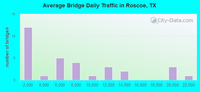
- 207,274Total average daily traffic
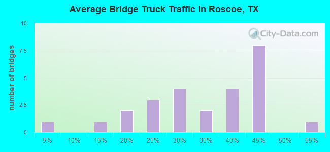
- 73,986Total average daily truck traffic
- National Bridge Inventory (NBI) Registered Bridges for Roscoe
- No street view available for this location
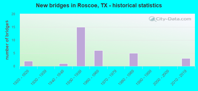
- New bridges - historical statistics
- 21920-1929
- 11940-1949
- 151950-1959
- 61960-1969
- 51980-1989
- 32010-2019
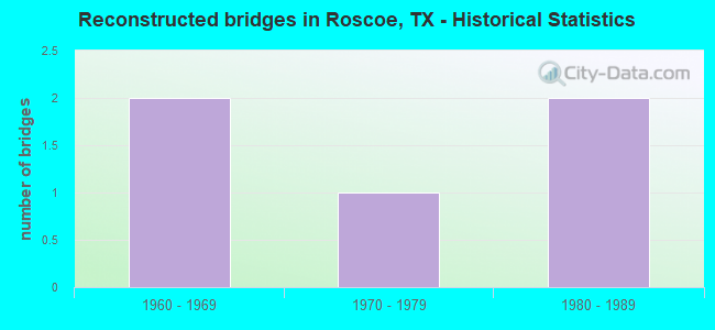
- Reconstructed bridges - Historical Statistics
- 21960-1969
- 11970-1979
- 21980-1989
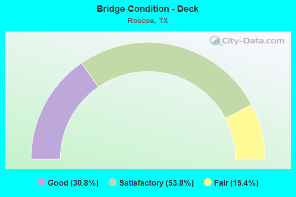
- Bridge Condition - Deck
- 30.8%Good
- 53.8%Satisfactory
- 15.4%Fair
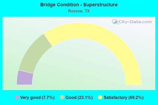
- Bridge Condition - Superstructure
- 7.7%Very good
- 23.1%Good
- 69.2%Satisfactory
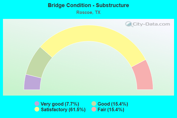
- Bridge Condition - Substructure
- 7.7%Very good
- 15.4%Good
- 61.5%Satisfactory
- 15.4%Fair
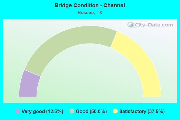
- Bridge Condition - Channel
- 12.5%Very good
- 50.0%Good
- 37.5%Satisfactory
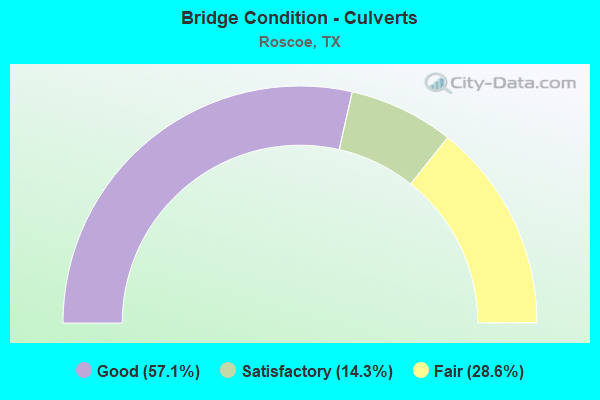
- Bridge Condition - Culverts
- 57.1%Good
- 14.3%Satisfactory
- 28.6%Fair
Find on map >> Show street view
Structure Number: 81770000602006, Location: 5.40 MI E OF MITCHELL C/L (Lat: 32.427325, Lng: -100.571983), Route carried "on" structure: ServiceInterstate 20, Year Built: 1925, Year Reconstructed: 1967, Status: Open, Structure Length: 0.70m (2.30ft), Average Daily Traffic: 90 (year 2013), Truck Traffic: 38%, Average Future Daily Traffic: 130 (year 2033), Design Load: H 15, Features Intersected: Cottonwood Creek Branch
Minimum Vertical Clearance: 30+ m (98+ ft), Kilometerpoint: 8.573, Lanes on structure: 2, Owner: State Highway Agency, Approaching Roadway Width: 7.3m (24.0ft), Material/Design: Concrete, Design/Construction: Culvert, Number Of Spans In Main Unit: 4, Length of Maximum Span: 1.5m (4.9ft), Curb-To-Curb Width: 12.8m (42.0ft), Out-to-Out Width: 13.2m (43.3ft)
Condition: Channel: Good, Culverts: Satisfactory, Operating Rating: 39.9 metric tons, Method Used To Determine Operating Rating: Load Factor (LF), Inventory Rating: 23.6 metric tons, Method Used To Determine Inventory Rating: Load Factor (LF), Structural Evaluation: Equal to present minimum criteria, Deck Geometry: Superior to present desirable criteria, Waterway Adequacy: Equal to present minimum criteria, Approach Roadway Alignment: Equal to present desirable criteria, Designated Inspection Frequency: Every 24 months, Inspection Date: March 2021, Deck Structure Type: Concrete Cast-file-Place, Wearing Surface/Protective System: Wearing Surface: Bituminous
Find on map >> Show street view
Structure Number: 81770000602007, Location: 1.4 MI W OF FM 608 (Lat: 32.430044, Lng: -100.558456), Route carried "on" structure: Interstate 20, Year Built: 1925, Year Reconstructed: 1965, Status: Open, Structure Length: 0.70m (2.30ft), Average Daily Traffic: 18,360 (year 2020), Truck Traffic: 43%, Average Future Daily Traffic: 18,970 (year 2033), Design Load: H 15, Features Intersected: Draw
Minimum Vertical Clearance: 30+ m (98+ ft), Kilometerpoint: 9.877, Lanes on structure: 8, Owner: State Highway Agency, Approaching Roadway Width: 38.4m (126.0ft), Skew: 20 degrees, Material/Design: Concrete, Design/Construction: Culvert, Number Of Spans In Main Unit: 5, Length of Maximum Span: 1.2m (3.9ft)
Condition: Channel: Satisfactory, Culverts: Fair, Operating Rating: 39.9 metric tons, Method Used To Determine Operating Rating: Load Factor (LF), Inventory Rating: 23.6 metric tons, Method Used To Determine Inventory Rating: Load Factor (LF), Structural Evaluation: Somewhat better than minimum adequacy, Waterway Adequacy: Equal to present minimum criteria, Approach Roadway Alignment: Equal to present desirable criteria, Designated Inspection Frequency: Every 24 months, Inspection Date: March 2021
Find on map >> Show street view
Structure Number: 81770000602092, Location: 1.2 MI W OF FM 608 (Lat: 32.430783, Lng: -100.555372), Route carried "on" structure: Interstate 20, Year Built: 1958, Status: Open, Structure Length: 3.47m (11.38ft), Average Daily Traffic: 10,826 (year 2019), Truck Traffic: 43%, Average Future Daily Traffic: 9,480 (year 2033), Design Load: HS 20, Features Intersected: IH 20 BUS
Minimum Vertical Clearance: 30+ m (98+ ft), Kilometerpoint: 10.161, Lanes on structure: 2, Lanes under structure: 2, Owner: State Highway Agency, Approaching Roadway Width: 11.6m (38.1ft), Material/Design: Concrete continuous, Design/Construction: Slab, Number Of Spans In Main Unit: 3, Length of Maximum Span: 13.7m (44.9ft), Curb-To-Curb Width: 11.6m (38.1ft), Out-to-Out Width: 12.2m (40.0ft)
Condition: Deck: Good, Superstructure: Good, Substructure: Good, Operating Rating: 40.8 metric tons, Method Used To Determine Operating Rating: Load Factor (LF), Inventory Rating: 24.5 metric tons, Method Used To Determine Inventory Rating: Load Factor (LF), Structural Evaluation: Equal to present minimum criteria, Deck Geometry: Equal to present minimum criteria, Underclear: High priority of corrective action, Approach Roadway Alignment: Equal to present desirable criteria, Designated Inspection Frequency: Every 24 months, Inspection Date: March 2021, Deck Structure Type: Concrete Cast-file-Place, Wearing Surface/Protective System: Wearing Surface: Bituminous
Find on map >> Show street view
Structure Number: 81770000602093, Location: 1.2 MI W OF FM 608 (Lat: 32.430531, Lng: -100.555308), Route carried "on" structure: Interstate 20, Year Built: 1958, Status: Open, Structure Length: 3.47m (11.38ft), Average Daily Traffic: 10,553 (year 2019), Truck Traffic: 43%, Average Future Daily Traffic: 9,480 (year 2033), Design Load: HS 20, Features Intersected: IH 20 BUS
Minimum Vertical Clearance: 30+ m (98+ ft), Kilometerpoint: 10.161, Lanes on structure: 2, Lanes under structure: 2, Owner: State Highway Agency, Approaching Roadway Width: 11.6m (38.1ft), Material/Design: Concrete continuous, Design/Construction: Slab, Number Of Spans In Main Unit: 3, Length of Maximum Span: 13.7m (44.9ft), Curb-To-Curb Width: 11.5m (37.7ft), Out-to-Out Width: 12.2m (40.0ft)
Condition: Deck: Satisfactory, Superstructure: Satisfactory, Substructure: Satisfactory, Operating Rating: 40.8 metric tons, Method Used To Determine Operating Rating: Load Factor (LF), Inventory Rating: 24.5 metric tons, Method Used To Determine Inventory Rating: Load Factor (LF), Structural Evaluation: Equal to present minimum criteria, Deck Geometry: Somewhat better than minimum adequacy, Underclear: High priority of corrective action, Approach Roadway Alignment: Equal to present desirable criteria, Designated Inspection Frequency: Every 24 months, Inspection Date: March 2021, Deck Structure Type: Concrete Cast-file-Place, Wearing Surface/Protective System: Wearing Surface: Bituminous
Find on map >> Show street view
Structure Number: 81770000602094, Location: 0.5 MI W OF FM 608 (Lat: 32.432733, Lng: -100.543556), Route carried "on" structure: Interstate 20, Year Built: 1958, Year Reconstructed: 1980, Status: Open, Structure Length: 0.67m (2.20ft), Average Daily Traffic: 18,154 (year 2020), Truck Traffic: 36%, Average Future Daily Traffic: 18,840 (year 2033), Features Intersected: CEDAR ST CREEK
Minimum Vertical Clearance: 30+ m (98+ ft), Kilometerpoint: 11.309, Lanes on structure: 6, Owner: State Highway Agency, Approaching Roadway Width: 29.3m (96.1ft), Skew: 20 degrees, Material/Design: Concrete, Design/Construction: Culvert, Number Of Spans In Main Unit: 4, Length of Maximum Span: 1.5m (4.9ft)
Condition: Channel: Good, Culverts: Good, Operating Rating: 39.9 metric tons, Method Used To Determine Operating Rating: Load Factor (LF), Inventory Rating: 23.6 metric tons, Method Used To Determine Inventory Rating: Load Factor (LF), Structural Evaluation: Somewhat better than minimum adequacy, Waterway Adequacy: Equal to present minimum criteria, Approach Roadway Alignment: Equal to present desirable criteria, Designated Inspection Frequency: Every 24 months, Inspection Date: March 2021
Find on map >> Show street view
Structure Number: 81770000602097, Location: 2.0 MI W OF US 84 N (Lat: 32.434522, Lng: -100.534767), Route carried "on" structure: Interstate 20, Year Built: 1958, Status: Open, Structure Length: 3.47m (11.38ft), Average Daily Traffic: 6,730 (year 2013), Truck Traffic: 36%, Average Future Daily Traffic: 9,420 (year 2033), Design Load: HS 20, Features Intersected: FM 608
Minimum Vertical Clearance: 30+ m (98+ ft), Kilometerpoint: 12.143, Lanes on structure: 2, Lanes under structure: 2, Owner: State Highway Agency, Approaching Roadway Width: 11.6m (38.1ft), Material/Design: Concrete continuous, Design/Construction: Slab, Number Of Spans In Main Unit: 3, Length of Maximum Span: 13.7m (44.9ft), Curb-To-Curb Width: 11.5m (37.7ft), Out-to-Out Width: 12.2m (40.0ft)
Condition: Deck: Good, Superstructure: Good, Substructure: Satisfactory, Operating Rating: 40.8 metric tons, Method Used To Determine Operating Rating: Load Factor (LF), Inventory Rating: 30.6 metric tons, Method Used To Determine Inventory Rating: Assigned ratings based on Allowable Stress Design (ASD) reported in metric tons, Structural Evaluation: Equal to present minimum criteria, Deck Geometry: Somewhat better than minimum adequacy, Underclear: Meets minimum limits, Approach Roadway Alignment: Equal to present desirable criteria, Designated Inspection Frequency: Every 24 months, Inspection Date: March 2021, Deck Structure Type: Concrete Cast-file-Place, Wearing Surface/Protective System: Wearing Surface: Bituminous
Find on map >> Show street view
Structure Number: 81770000602098, Location: 2.0 MI W OF US 84 N (Lat: 32.434350, Lng: -100.534736), Route carried "on" structure: Interstate 20, Year Built: 1958, Status: Open, Structure Length: 3.47m (11.38ft), Average Daily Traffic: 6,730 (year 2013), Truck Traffic: 36%, Average Future Daily Traffic: 9,420 (year 2033), Design Load: HS 20, Features Intersected: FM 608
Minimum Vertical Clearance: 30+ m (98+ ft), Kilometerpoint: 12.143, Lanes on structure: 2, Lanes under structure: 2, Owner: State Highway Agency, Approaching Roadway Width: 11.6m (38.1ft), Material/Design: Concrete continuous, Design/Construction: Slab, Number Of Spans In Main Unit: 3, Length of Maximum Span: 13.7m (44.9ft), Curb-To-Curb Width: 11.5m (37.7ft), Out-to-Out Width: 12.2m (40.0ft)
Condition: Deck: Satisfactory, Superstructure: Satisfactory, Substructure: Satisfactory, Operating Rating: 40.8 metric tons, Method Used To Determine Operating Rating: Load Factor (LF), Inventory Rating: 24.5 metric tons, Method Used To Determine Inventory Rating: Load Factor (LF), Structural Evaluation: Equal to present minimum criteria, Deck Geometry: Somewhat better than minimum adequacy, Underclear: Meets minimum limits, Approach Roadway Alignment: Equal to present desirable criteria, Designated Inspection Frequency: Every 24 months, Inspection Date: March 2021, Deck Structure Type: Concrete Cast-file-Place, Wearing Surface/Protective System: Wearing Surface: Bituminous
Find on map >> Show street view
Structure Number: 81770000602099, Location: 1.0 MI W OF US 84 N (Lat: 32.437794, Lng: -100.518172), Route carried "on" structure: Interstate 20, Year Built: 1958, Status: Open, Structure Length: 3.47m (11.38ft), Average Daily Traffic: 7,140 (year 2013), Truck Traffic: 43%, Average Future Daily Traffic: 10,000 (year 2033), Design Load: HS 20, Features Intersected: CEMETERY RD
Minimum Vertical Clearance: 30+ m (98+ ft), Kilometerpoint: 13.745, Lanes on structure: 2, Lanes under structure: 2, Owner: State Highway Agency, Approaching Roadway Width: 11.6m (38.1ft), Material/Design: Concrete continuous, Design/Construction: Slab, Number Of Spans In Main Unit: 3, Length of Maximum Span: 13.7m (44.9ft), Curb-To-Curb Width: 11.5m (37.7ft), Out-to-Out Width: 12.2m (40.0ft)
Condition: Deck: Satisfactory, Superstructure: Satisfactory, Substructure: Satisfactory, Operating Rating: 39.9 metric tons, Method Used To Determine Operating Rating: Load Factor (LF), Inventory Rating: 23.6 metric tons, Method Used To Determine Inventory Rating: Load Factor (LF), Structural Evaluation: Somewhat better than minimum adequacy, Deck Geometry: Somewhat better than minimum adequacy, Underclear: High priority of corrective action, Approach Roadway Alignment: Equal to present desirable criteria, Designated Inspection Frequency: Every 24 months, Inspection Date: March 2021, Deck Structure Type: Concrete Cast-file-Place, Wearing Surface/Protective System: Wearing Surface: Bituminous
Find on map >> Show street view
Structure Number: 817700006021, Location: 1.0 MI W OF US 84 N (Lat: 32.437622, Lng: -100.518136), Route carried "on" structure: Interstate 20, Year Built: 1958, Status: Open, Structure Length: 3.47m (11.38ft), Average Daily Traffic: 7,140 (year 2013), Truck Traffic: 43%, Average Future Daily Traffic: 10,000 (year 2033), Design Load: HS 20, Features Intersected: CEMETERY RD
Minimum Vertical Clearance: 30+ m (98+ ft), Kilometerpoint: 13.745, Lanes on structure: 2, Lanes under structure: 2, Owner: State Highway Agency, Approaching Roadway Width: 11.6m (38.1ft), Material/Design: Concrete continuous, Design/Construction: Slab, Number Of Spans In Main Unit: 3, Length of Maximum Span: 13.7m (44.9ft), Curb-To-Curb Width: 11.5m (37.7ft), Out-to-Out Width: 12.2m (40.0ft)
Condition: Deck: Good, Superstructure: Good, Substructure: Satisfactory, Operating Rating: 39.9 metric tons, Method Used To Determine Operating Rating: Load Factor (LF), Inventory Rating: 23.6 metric tons, Method Used To Determine Inventory Rating: Load Factor (LF), Structural Evaluation: Somewhat better than minimum adequacy, Deck Geometry: Somewhat better than minimum adequacy, Underclear: High priority of corrective action, Approach Roadway Alignment: Equal to present desirable criteria, Designated Inspection Frequency: Every 24 months, Inspection Date: March 2021, Deck Structure Type: Concrete Cast-file-Place, Wearing Surface/Protective System: Wearing Surface: Bituminous
Find on map >> Show street view
Structure Number: 81770000602102, Location: 9.75 MI E of Mitchell C/L (Lat: 32.446814, Lng: -100.503008), Route carried "on" structure: County highway , Year Built: 1958, Year Reconstructed: 1981, Status: Posted for load, Structure Length: 10.52m (34.51ft), Average Daily Traffic: 70 (year 2017), Average Future Daily Traffic: 110 (year 2037), Design Load: H 15, Features Intersected: IH 20, Facility Carried by Structure: Blackland Rd.
Minimum Vertical Clearance: 30+ m (98+ ft), Kilometerpoint: 18.507, Lanes on structure: 2, Lanes under structure: 10, Owner: State Highway Agency, Approaching Roadway Width: 7.3m (24.0ft), Material/Design: Steel continuous, Design/Construction: Stringer/Multi-beam, Number Of Spans In Main Unit: 4, Number Of Approach Spans: 3, Length of Maximum Span: 25.9m (85.0ft), Curb-To-Curb Width: 7.2m (23.6ft), Out-to-Out Width: 7.8m (25.6ft)
Condition: Deck: Fair, Superstructure: Satisfactory, Substructure: Fair, Operating Rating: 32.7 metric tons, Method Used To Determine Operating Rating: Load Factor (LF), Inventory Rating: 19.0 metric tons, Method Used To Determine Inventory Rating: Load Factor (LF), Structural Evaluation: Somewhat better than minimum adequacy, Deck Geometry: Somewhat better than minimum adequacy, Underclear: High priority of corrective action, Approach Roadway Alignment: Equal to present desirable criteria, Bridge Posting: Required (Relationship of Operating Rating to Maximum Legal Load: 20.0 - 29.9% below), Length Of Structure Improvement: 10.52m (34.51ft), Designated Inspection Frequency: Every 24 months, Inspection Date: March 2021, Bridge Improvement Cost: $17,000, Roadway Improvement Cost: $4,000, Total Project Cost: $21,000, Deck Structure Type: Concrete Cast-file-Place, Wearing Surface/Protective System: Wearing Surface: Bituminous
Find on map >> Show street view
Structure Number: 81770000602308, Location: 3.60 MI E OF MITCHELL C/L (Lat: 32.421997, Lng: -100.602033), Route carried "on" structure: County highway , Year Built: 1967, Status: Open, Structure Length: 10.67m (35.01ft), Average Daily Traffic: 100 (year 2020), Average Future Daily Traffic: 50 (year 2033), Design Load: H 15, Features Intersected: IH 20, Facility Carried by Structure: JARRATT NORRIS RD
Minimum Vertical Clearance: 30+ m (98+ ft), Kilometerpoint: 11.265, Lanes on structure: 2, Lanes under structure: 8, Owner: State Highway Agency, Approaching Roadway Width: 7.3m (24.0ft), Material/Design: Concrete continuous, Design/Construction: Tee Beam, Number Of Spans In Main Unit: 4, Number Of Approach Spans: 2, Length of Maximum Span: 21.3m (69.9ft), Curb-To-Curb Width: 7.7m (25.3ft), Out-to-Out Width: 8.6m (28.2ft)
Condition: Deck: Satisfactory, Superstructure: Satisfactory, Substructure: Good, Operating Rating: 41.7 metric tons, Method Used To Determine Operating Rating: Load Factor (LF), Inventory Rating: 24.5 metric tons, Method Used To Determine Inventory Rating: Load Factor (LF), Structural Evaluation: Equal to present minimum criteria, Deck Geometry: Equal to present minimum criteria, Underclear: Somewhat better than minimum adequacy, Approach Roadway Alignment: Equal to present desirable criteria, Designated Inspection Frequency: Every 24 months, Inspection Date: March 2021, Deck Structure Type: Concrete Cast-file-Place
Find on map >> Show street view
Structure Number: 81770000602309, Location: 4.65 MI E of Mitchell C/L (Lat: 32.425197, Lng: -100.585061), Route carried "on" structure: County highway , Year Built: 1967, Status: Open, Structure Length: 10.67m (35.01ft), Average Daily Traffic: 100 (year 2020), Average Future Daily Traffic: 65 (year 2033), Design Load: H 15, Features Intersected: IH 20, Facility Carried by Structure: Duncan Hastings Rd
Minimum Vertical Clearance: 30+ m (98+ ft), Kilometerpoint: 1.448, Lanes on structure: 2, Lanes under structure: 8, Owner: State Highway Agency, Approaching Roadway Width: 7.3m (24.0ft), Material/Design: Concrete continuous, Design/Construction: Tee Beam, Number Of Spans In Main Unit: 4, Number Of Approach Spans: 2, Length of Maximum Span: 21.3m (69.9ft), Curb-To-Curb Width: 7.7m (25.3ft), Out-to-Out Width: 8.6m (28.2ft)
Condition: Deck: Satisfactory, Superstructure: Satisfactory, Substructure: Satisfactory, Operating Rating: 41.7 metric tons, Method Used To Determine Operating Rating: Load Factor (LF), Inventory Rating: 24.5 metric tons, Method Used To Determine Inventory Rating: Load Factor (LF), Structural Evaluation: Equal to present minimum criteria, Deck Geometry: Equal to present minimum criteria, Underclear: Somewhat better than minimum adequacy, Approach Roadway Alignment: Equal to present desirable criteria, Length Of Structure Improvement: 11.80m (38.71ft), Designated Inspection Frequency: Every 24 months, Inspection Date: March 2021, Bridge Improvement Cost: $516,000, Roadway Improvement Cost: $129,000, Total Project Cost: $645,000, Deck Structure Type: Concrete Cast-file-Place
Find on map >> Show street view
Structure Number: 8177000060231, Location: 5.40 MI E of Mitchell C/L (Lat: 32.427708, Lng: -100.572039), Route carried "on" structure: Interstate 20, Year Built: 1967, Year Reconstructed: 1980, Status: Open, Structure Length: 0.73m (2.40ft), Average Daily Traffic: 18,360 (year 2020), Truck Traffic: 43%, Average Future Daily Traffic: 18,970 (year 2033), Design Load: HS 20, Features Intersected: Cottonwood Creek Branch
Minimum Vertical Clearance: 30+ m (98+ ft), Kilometerpoint: 8.573, Lanes on structure: 6, Owner: State Highway Agency, Approaching Roadway Width: 30.5m (100.1ft), Skew: 31 degrees, Material/Design: Concrete, Design/Construction: Culvert, Number Of Spans In Main Unit: 4, Length of Maximum Span: 1.5m (4.9ft)
Condition: Channel: Good, Culverts: Good, Operating Rating: 39.9 metric tons, Method Used To Determine Operating Rating: Load Factor (LF), Inventory Rating: 23.6 metric tons, Method Used To Determine Inventory Rating: Load Factor (LF), Structural Evaluation: Somewhat better than minimum adequacy, Waterway Adequacy: Equal to present minimum criteria, Approach Roadway Alignment: Equal to present desirable criteria, Designated Inspection Frequency: Every 24 months, Inspection Date: March 2021
Find on map >> Show street view
Structure Number: 8177000060234, Location: 9.55 MI E of Mitchell C/L (Lat: 32.445664, Lng: -100.507217), Route carried "on" structure: US 84, Year Built: 2013, Status: Open, Structure Length: 3.96m (12.99ft), Average Daily Traffic: 5,160 (year 2012), Truck Traffic: 31%, Average Future Daily Traffic: 6,520 (year 2032), Design Load: HL 93, Features Intersected: IH 20 WB
Minimum Vertical Clearance: 30+ m (98+ ft), Kilometerpoint: 17.635, Lanes on structure: 1, Lanes under structure: 2, Owner: State Highway Agency, Approaching Roadway Width: 8.5m (27.9ft), Skew: 5 degrees, Material/Design: Prestressed concrete, Design/Construction: Stringer/Multi-beam, Number Of Spans In Main Unit: 1, Length of Maximum Span: 39.6m (129.9ft), Curb-To-Curb Width: 8.4m (27.6ft), Out-to-Out Width: 9.1m (29.9ft)
Condition: Deck: Good, Superstructure: Very good, Substructure: Very good, Operating Rating: 54.4 metric tons, Method Used To Determine Operating Rating: Assigned ratings based on Load and Resistance Factor Design (LRFD) reported in metric tons, Inventory Rating: 32.7 metric tons, Method Used To Determine Inventory Rating: Assigned ratings based on Load and Resistance Factor Design (LRFD) reported in metric tons, Structural Evaluation: Equal to present desirable criteria, Deck Geometry: High priority of replacement, Underclear: Equal to present minimum criteria, Approach Roadway Alignment: Somewhat better than minimum adequacy, Designated Inspection Frequency: Every 24 months, Inspection Date: March 2021, Deck Structure Type: Concrete Precast Panels, Wearing Surface/Protective System: Deck Protection: Epoxy Coated Reinforcing
Find on map >> Show street view
Structure Number: 81770005312043, Location: 5.30 MI NW OF IH 20 (Lat: 32.467675, Lng: -100.591614), Route carried "on" structure: US 84, Year Built: 1962, Status: Open, Structure Length: 1.95m (6.40ft), Average Daily Traffic: 4,890 (year 2013), Truck Traffic: 23%, Average Future Daily Traffic: 6,850 (year 2033), Design Load: HS 20, Features Intersected: COTTONWOOD CREEK
Minimum Vertical Clearance: 30+ m (98+ ft), Kilometerpoint: 9.054, Lanes on structure: 2, Owner: State Highway Agency, Approaching Roadway Width: 12.2m (40.0ft), Material/Design: Concrete, Design/Construction: Culvert, Number Of Spans In Main Unit: 6, Length of Maximum Span: 3.0m (9.8ft), Curb-To-Curb Width: 12.9m (42.3ft), Out-to-Out Width: 17.8m (58.4ft)
Condition: Channel: Satisfactory, Culverts: Fair, Operating Rating: 39.9 metric tons, Method Used To Determine Operating Rating: Load Factor (LF), Inventory Rating: 23.6 metric tons, Method Used To Determine Inventory Rating: Load Factor (LF), Structural Evaluation: Somewhat better than minimum adequacy, Deck Geometry: Superior to present desirable criteria, Waterway Adequacy: Equal to present minimum criteria, Approach Roadway Alignment: Equal to present desirable criteria, Designated Inspection Frequency: Every 24 months, Inspection Date: March 2021, Deck Structure Type: Concrete Cast-file-Place, Wearing Surface/Protective System: Wearing Surface: Bituminous
Find on map >> Show street view
Structure Number: 81770005312082, Location: 1.60 MI NW OF IH 20 (Lat: 32.455378, Lng: -100.531511), Route carried "on" structure: US 84, Year Built: 1982, Status: Open, Structure Length: 0.67m (2.20ft), Average Daily Traffic: 9,601 (year 2020), Truck Traffic: 25%, Average Future Daily Traffic: 11,990 (year 2033), Design Load: HS 20, Features Intersected: DRAIN
Minimum Vertical Clearance: 30+ m (98+ ft), Kilometerpoint: 15.109, Lanes on structure: 4, Owner: State Highway Agency, Approaching Roadway Width: 23.2m (76.1ft), Skew: 20 degrees, Material/Design: Concrete, Design/Construction: Culvert, Number Of Spans In Main Unit: 4, Length of Maximum Span: 1.5m (4.9ft)
Condition: Channel: Very good, Culverts: Good, Operating Rating: 39.9 metric tons, Method Used To Determine Operating Rating: Load Factor (LF), Inventory Rating: 23.6 metric tons, Method Used To Determine Inventory Rating: Load Factor (LF), Structural Evaluation: Somewhat better than minimum adequacy, Waterway Adequacy: Equal to present minimum criteria, Approach Roadway Alignment: Equal to present desirable criteria, Designated Inspection Frequency: Every 48 months, Inspection Date: March 2019
Find on map >> Show street view
Structure Number: 81770005312083, Location: 0.80 MI NW of IH 20 (Lat: 32.449839, Lng: -100.520225), Route carried "on" structure: US 84, Year Built: 1982, Status: Open, Structure Length: 13.35m (43.80ft), Average Daily Traffic: 5,014 (year 2019), Truck Traffic: 25%, Average Future Daily Traffic: 5,990 (year 2033), Design Load: HS 20, Features Intersected: UP RR & Bus 84
Minimum Vertical Clearance: 30+ m (98+ ft), Kilometerpoint: 16.277, Lanes on structure: 2, Lanes under structure: 2, Owner: State Highway Agency, Approaching Roadway Width: 11.6m (38.1ft), Skew: 5 degrees, Material/Design: Prestressed concrete, Design/Construction: Stringer/Multi-beam, Number Of Spans In Main Unit: 4, Number Of Approach Spans: 2, Length of Maximum Span: 30.5m (100.1ft), Curb-To-Curb Width: 11.6m (38.1ft), Out-to-Out Width: 12.2m (40.0ft)
Condition: Deck: Satisfactory, Superstructure: Satisfactory, Substructure: Satisfactory, Operating Rating: 54.4 metric tons, Method Used To Determine Operating Rating: Assigned rating based on Load Factor Design (LFD) reported in metric tons, Inventory Rating: 32.7 metric tons, Method Used To Determine Inventory Rating: Assigned rating based on Load Factor Design (LFD) reported in metric tons, Structural Evaluation: Equal to present minimum criteria, Deck Geometry: Better than present minimum criteria, Underclear: Superior to present desirable criteria, Approach Roadway Alignment: Equal to present desirable criteria, Designated Inspection Frequency: Every 24 months, Inspection Date: March 2021, Deck Structure Type: Concrete Cast-file-Place, Wearing Surface/Protective System: Wearing Surface: Bituminous
Find on map >> Show street view
Structure Number: 81770005312084, Location: 0.80 MI NW of IH 20 (Lat: 32.449922, Lng: -100.520164), Route carried "on" structure: US 84, Year Built: 1982, Status: Open, Structure Length: 13.35m (43.80ft), Average Daily Traffic: 5,343 (year 2019), Truck Traffic: 25%, Average Future Daily Traffic: 5,990 (year 2033), Design Load: HS 20, Features Intersected: UP RR & Bus 84
Minimum Vertical Clearance: 30+ m (98+ ft), Kilometerpoint: 16.277, Lanes on structure: 2, Lanes under structure: 2, Owner: State Highway Agency, Approaching Roadway Width: 11.6m (38.1ft), Skew: 5 degrees, Material/Design: Prestressed concrete, Design/Construction: Stringer/Multi-beam, Number Of Spans In Main Unit: 4, Number Of Approach Spans: 2, Length of Maximum Span: 30.5m (100.1ft), Curb-To-Curb Width: 11.6m (38.1ft), Out-to-Out Width: 12.2m (40.0ft)
Condition: Deck: Fair, Superstructure: Satisfactory, Substructure: Satisfactory, Operating Rating: 54.4 metric tons, Method Used To Determine Operating Rating: Assigned rating based on Load Factor Design (LFD) reported in metric tons, Inventory Rating: 32.7 metric tons, Method Used To Determine Inventory Rating: Assigned rating based on Load Factor Design (LFD) reported in metric tons, Structural Evaluation: Equal to present minimum criteria, Deck Geometry: Better than present minimum criteria, Underclear: Better than present minimum criteria, Approach Roadway Alignment: Equal to present desirable criteria, Designated Inspection Frequency: Every 24 months, Inspection Date: March 2021, Deck Structure Type: Concrete Cast-file-Place, Wearing Surface/Protective System: Wearing Surface: Bituminous
Find on map >> Show street view
Structure Number: 81770005312189, Location: 5.3 MI NW of IH 20 (Lat: 32.467486, Lng: -100.591756), Route carried "on" structure: US 84, Year Built: 2014, Status: Open, Structure Length: 1.95m (6.40ft), Average Daily Traffic: 10,723 (year 2019), Truck Traffic: 10%, Average Future Daily Traffic: 5,810 (year 2030), Design Load: HS 20, Features Intersected: COTTONWOOD CREEK
Minimum Vertical Clearance: 30+ m (98+ ft), Kilometerpoint: 9.053, Lanes on structure: 2, Owner: State Highway Agency, Approaching Roadway Width: 11.6m (38.1ft), Material/Design: Concrete, Design/Construction: Culvert, Number Of Spans In Main Unit: 6, Length of Maximum Span: 3.0m (9.8ft)
Condition: Channel: Good, Culverts: Good, Operating Rating: 44.4 metric tons, Method Used To Determine Operating Rating: No rating analysis performed, Inventory Rating: 32.7 metric tons, Method Used To Determine Inventory Rating: No rating analysis performed, Structural Evaluation: Better than present minimum criteria, Waterway Adequacy: Equal to present desirable criteria, Approach Roadway Alignment: Equal to present desirable criteria, Designated Inspection Frequency: Every 48 months, Inspection Date: August 2021
Find on map >> Show street view
Structure Number: 81770AA0111001, Location: 1.80 MI N OF US 84 (Lat: 32.487747, Lng: -100.583786), Route carried "on" structure: County highway 111, Year Built: 1945, Status: Posted for load, Structure Length: 0.94m (3.08ft), Average Daily Traffic: 100 (year 2020), Average Future Daily Traffic: 100 (year 2027), Features Intersected: COTTONWOOD CREEK
Minimum Vertical Clearance: 30+ m (98+ ft), Kilometerpoint: 18.025, Lanes on structure: 1, Owner: County Highway Agency, Approaching Roadway Width: 4.3m (14.1ft), Material/Design: Steel, Design/Construction: Stringer/Multi-beam, Number Of Spans In Main Unit: 1, Length of Maximum Span: 8.8m (28.9ft), Curb-To-Curb Width: 4.5m (14.8ft), Out-to-Out Width: 4.5m (14.8ft)
Condition: Deck: Satisfactory, Superstructure: Satisfactory, Substructure: Fair, Channel: Satisfactory, Operating Rating: 24.5 metric tons, Method Used To Determine Operating Rating: Field evaluation and documented engineering judgment, Inventory Rating: 16.3 metric tons, Method Used To Determine Inventory Rating: Field evaluation and documented engineering judgment, Structural Evaluation: Somewhat better than minimum adequacy, Deck Geometry: Equal to present minimum criteria, Waterway Adequacy: Meets minimum limits, Approach Roadway Alignment: Somewhat better than minimum adequacy, Bridge Posting: Required (Relationship of Operating Rating to Maximum Legal Load: 20.0 - 29.9% below), Length Of Structure Improvement: 0.91m (2.99ft), Designated Inspection Frequency: Every 24 months, Inspection Date: March 2020, Bridge Improvement Cost: $68,000, Roadway Improvement Cost: $3,000, Total Project Cost: $71,000, Deck Structure Type: Concrete Cast-file-Place, Wearing Surface/Protective System: Wearing Surface: Gravel
Find on map >> Show street view
Structure Number: 81770000602092, Location: 1.2 MI W OF FM 608 (Lat: 32.430753, Lng: -100.555372), Route carried "under" structure: Business State highway 20, Year Built: 1958, Structure Length: 0. m, Average Daily Traffic: 390 (year 2013), Truck Traffic: 20%, Features Intersected: IH 20 BUS
Minimum Vertical Clearance: 4.44m (14.57ft), Kilometerpoint: 0.051, Lanes on structure: 2, Lanes under structure: 2, Material/Design: Concrete continuous, Design/Construction: Slab, Length of Maximum Span: 13.7m (44.9ft)
Find on map >> Show street view
Structure Number: 81770000602093, Location: 1.2 MI W OF FM 608 (Lat: 32.430575, Lng: -100.555322), Route carried "under" structure: Business State highway 20, Year Built: 1958, Structure Length: 0. m, Average Daily Traffic: 390 (year 2013), Truck Traffic: 20%, Features Intersected: IH 20 BUS
Minimum Vertical Clearance: 4.42m (14.50ft), Kilometerpoint: 0.034, Lanes on structure: 2, Lanes under structure: 2, Material/Design: Concrete continuous, Design/Construction: Slab, Length of Maximum Span: 13.7m (44.9ft)
Find on map >> Show street view
Structure Number: 81770000602097, Location: 2.0 MI W OF US 84 N (Lat: 32.434544, Lng: -100.534775), Route carried "under" structure: State highway 608, Year Built: 1958, Structure Length: 0. m, Average Daily Traffic: 2,940 (year 2013), Truck Traffic: 15%, Features Intersected: FM 608, Facility Carried by Structure: IH 20 WB
Minimum Vertical Clearance: 4.47m (14.67ft), Kilometerpoint: 2.866, Lanes on structure: 2, Lanes under structure: 2, Material/Design: Concrete continuous, Design/Construction: Slab, Length of Maximum Span: 13.7m (44.9ft)
Find on map >> Show street view
Structure Number: 81770000602098, Location: 2.0 MI W OF US 84 N (Lat: 32.434358, Lng: -100.534717), Route carried "under" structure: State highway 608, Year Built: 1958, Structure Length: 0. m, Average Daily Traffic: 1,410 (year 2013), Truck Traffic: 15%, Features Intersected: FM 608, Facility Carried by Structure: IH 20 EB
Minimum Vertical Clearance: 4.44m (14.57ft), Kilometerpoint: 2.929, Lanes on structure: 2, Lanes under structure: 2, Material/Design: Concrete continuous, Design/Construction: Slab, Length of Maximum Span: 13.7m (44.9ft)
Find on map >> Show street view
Structure Number: 81770000602099, Location: 1.0 MI W OF US 84 N (Lat: 32.437814, Lng: -100.518175), Route carried "under" structure: Other road , Year Built: 1958, Structure Length: 0. m, Average Daily Traffic: 50 (year 2011), Features Intersected: CEMETERY RD, Facility Carried by Structure: IH 20 WB
Minimum Vertical Clearance: 4.17m (13.68ft), Kilometerpoint: 0.000, Lanes on structure: 2, Lanes under structure: 2, Material/Design: Concrete continuous, Design/Construction: Slab, Length of Maximum Span: 13.7m (44.9ft)
Find on map >> Show street view
Structure Number: 817700006021, Location: 1.0 MI W OF US 84 N (Lat: 32.437636, Lng: -100.518122), Route carried "under" structure: Other road , Year Built: 1958, Structure Length: 0. m, Average Daily Traffic: 50 (year 2011), Features Intersected: CEMETERY RD, Facility Carried by Structure: IH 20 EB
Minimum Vertical Clearance: 4.14m (13.58ft), Kilometerpoint: 0.000, Lanes on structure: 2, Lanes under structure: 2, Material/Design: Concrete continuous, Design/Construction: Slab, Length of Maximum Span: 13.7m (44.9ft)
Find on map >> Show street view
Structure Number: 81770000602102, Location: 9.75 MI E of Mitchell C/L (Lat: 32.446814, Lng: -100.503008), Route carried "under" structure: Interstate 20, Year Built: 1958, Structure Length: 0. m, Average Daily Traffic: 21,700 (year 2013), Truck Traffic: 33%, Features Intersected: IH 20, Facility Carried by Structure: Blackland Rd.
Minimum Vertical Clearance: 5.72m (18.77ft), Kilometerpoint: 15.630, Lanes on structure: 2, Lanes under structure: 10, Material/Design: Steel continuous, Design/Construction: Stringer/Multi-beam, Length of Maximum Span: 25.9m (85.0ft)
Find on map >> Show street view
Structure Number: 81770000602308, Location: 3.60 MI E OF MITCHELL C/L (Lat: 32.421997, Lng: -100.602033), Route carried "under" structure: Interstate 20, Year Built: 1967, Structure Length: 0. m, Average Daily Traffic: 13,550 (year 2013), Truck Traffic: 43%, Features Intersected: IH 20, Facility Carried by Structure: JARRATT NORRIS RD
Minimum Vertical Clearance: 5.11m (16.77ft), Kilometerpoint: 5.707, Lanes on structure: 2, Lanes under structure: 8, Material/Design: Concrete continuous, Design/Construction: Tee Beam, Length of Maximum Span: 21.3m (69.9ft)
Find on map >> Show street view
Structure Number: 81770000602309, Location: 4.65 MI E of Mitchell C/L (Lat: 32.425197, Lng: -100.585061), Route carried "under" structure: Interstate 20, Year Built: 1967, Structure Length: 0. m, Average Daily Traffic: 13,550 (year 2013), Truck Traffic: 43%, Features Intersected: IH 20, Facility Carried by Structure: Duncan Hastings Rd
Minimum Vertical Clearance: 5.16m (16.93ft), Kilometerpoint: 7.340, Lanes on structure: 2, Lanes under structure: 8, Material/Design: Concrete continuous, Design/Construction: Tee Beam, Length of Maximum Span: 21.3m (69.9ft)
Find on map >> Show street view
Structure Number: 8177000060234, Location: 9.55 MI E of Mitchell C/L (Lat: 32.445664, Lng: -100.507217), Route carried "under" structure: Interstate 20, Year Built: 2013, Structure Length: 0. m, Average Daily Traffic: 5,240 (year 2011), Truck Traffic: 51%, Features Intersected: IH 20 WB, Facility Carried by Structure: US 84 EB
Minimum Vertical Clearance: 5.26m (17.26ft), Kilometerpoint: 15.495, Lanes on structure: 1, Lanes under structure: 2, Material/Design: Prestressed concrete, Design/Construction: Stringer/Multi-beam, Length of Maximum Span: 39.6m (129.9ft)
Find on map >> Show street view
Structure Number: 81770005312083, Location: 0.80 MI NW of IH 20 (Lat: 32.449700, Lng: -100.519975), Route carried "under" structure: Business State highway 84, Year Built: 1982, Structure Length: 0. m, Average Daily Traffic: 1,600 (year 2013), Truck Traffic: 3%, Features Intersected: UP RR & Bus 84
Minimum Vertical Clearance: 8.10m (26.57ft), Kilometerpoint: 1.658, Lanes on structure: 2, Lanes under structure: 2, Material/Design: Prestressed concrete, Design/Construction: Stringer/Multi-beam, Length of Maximum Span: 30.5m (100.1ft)
Find on map >> Show street view
Structure Number: 81770005312084, Location: 0.80 MI NW of IH 20 (Lat: 32.449731, Lng: -100.519783), Route carried "under" structure: Business State highway 84, Year Built: 1982, Structure Length: 0. m, Average Daily Traffic: 1,220 (year 2013), Truck Traffic: 27%, Features Intersected: UP RR & Bus 84
Minimum Vertical Clearance: 7.95m (26.08ft), Kilometerpoint: 5.177, Lanes on structure: 2, Lanes under structure: 2, Material/Design: Prestressed concrete, Design/Construction: Stringer/Multi-beam, Length of Maximum Span: 30.5m (100.1ft)