Bridge Statistics for Royersford, Pennsylvania (PA)
Condition, Traffic, Stress, Structural Evaluation, Project Costs
- National Bridge Inventory (NBI) Statistics
- 31Number of bridges
- 194ft / 59.4mTotal length
- $1,394,000Total costs
- 569,324Total average daily traffic
- 59,229Total average daily truck traffic
- National Bridge Inventory (NBI) Registered Bridges for Royersford
- No street view available for this location
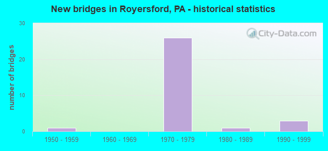
- New bridges - historical statistics
- 11950-1959
- 261970-1979
- 11980-1989
- 31990-1999
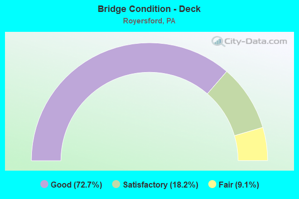
- Bridge Condition - Deck
- 72.7%Good
- 18.2%Satisfactory
- 9.1%Fair
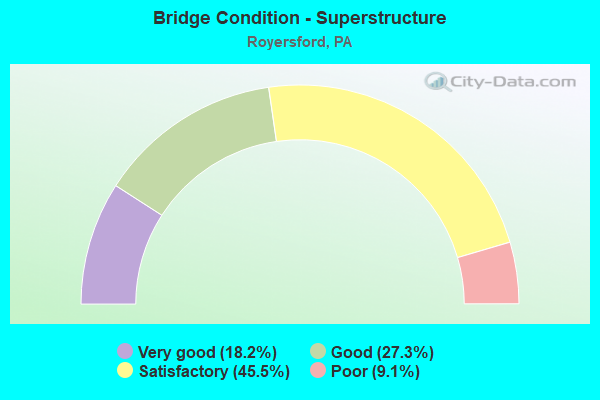
- Bridge Condition - Superstructure
- 18.2%Very good
- 27.3%Good
- 45.5%Satisfactory
- 9.1%Poor
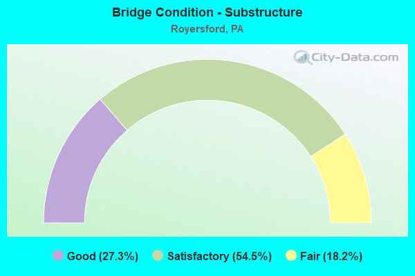
- Bridge Condition - Substructure
- 27.3%Good
- 54.5%Satisfactory
- 18.2%Fair
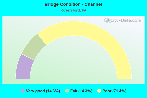
- Bridge Condition - Channel
- 14.3%Very good
- 14.3%Fair
- 71.4%Poor
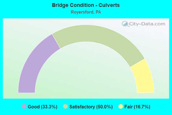
- Bridge Condition - Culverts
- 33.3%Good
- 50.0%Satisfactory
- 16.7%Fair
Find on map >> Show street view
Structure Number: 27422, Location: LIMERICK INT. 18K3/3140C6 (Lat: 40.217219, Lng: -75.544656), Route carried "on" structure: US 422, Year Built: 1976, Status: Open, Structure Length: 6.34m (20.80ft), Average Daily Traffic: 26,804 (year 2022), Truck Traffic: 9%, Average Future Daily Traffic: 32,897 (year 2032), Design Load: HS 20+Mod, Features Intersected: LEWIS ROAD, Facility Carried by Structure: P-TOWN X-WAY (EB)
Minimum Vertical Clearance: 30+ m (98+ ft), Kilometerpoint: 10.527, Lanes on structure: 2, Lanes under structure: 2, Base Highway Network: Yes, Owner: State Highway Agency, Approaching Roadway Width: 17.1m (56.1ft), Skew: 13 degrees, Material/Design: Steel, Design/Construction: Stringer/Multi-beam, Number Of Spans In Main Unit: 1, Number Of Approach Spans: 2, Length of Maximum Span: 36.9m (121.1ft), Curb or Sidewalk Widths: Left: 0.2m (0.7ft), Right: 0.2m (0.7ft), Curb-To-Curb Width: 11.9m (39.0ft), Out-to-Out Width: 13.2m (43.3ft)
Condition: Deck: Good, Superstructure: Very good, Substructure: Good, Operating Rating: 75.3 metric tons, Method Used To Determine Operating Rating: Load Factor (LF), Inventory Rating: 45.4 metric tons, Method Used To Determine Inventory Rating: Load Factor (LF), Structural Evaluation: Better than present minimum criteria, Deck Geometry: Equal to present minimum criteria, Underclear: Somewhat better than minimum adequacy, Approach Roadway Alignment: Equal to present desirable criteria, Length Of Structure Improvement: 7.30m (23.95ft), Designated Inspection Frequency: Every 24 months, Inspection Date: December 2020, Deck Structure Type: Concrete Cast-file-Place, Wearing Surface/Protective System: Wearing Surface: Monolithic Concrete, Deck Protection: Galvanized Reinforcing
Find on map >> Show street view
Structure Number: 27423, Location: LIMERICK INT. 19A3/3140C6 (Lat: 40.217372, Lng: -75.544467), Route carried "on" structure: US 422, Year Built: 1976, Status: Open, Structure Length: 6.34m (20.80ft), Average Daily Traffic: 22,943 (year 2022), Truck Traffic: 12%, Average Future Daily Traffic: 33,383 (year 2032), Design Load: HS 20+Mod, Features Intersected: LEWIS ROAD, Facility Carried by Structure: P-TOWN X-WAY (WB)
Minimum Vertical Clearance: 30+ m (98+ ft), Kilometerpoint: 10.549, Lanes on structure: 2, Lanes under structure: 2, Base Highway Network: Yes, Owner: State Highway Agency, Approaching Roadway Width: 17.1m (56.1ft), Skew: 13 degrees, Material/Design: Steel, Design/Construction: Stringer/Multi-beam, Number Of Spans In Main Unit: 1, Number Of Approach Spans: 2, Length of Maximum Span: 36.9m (121.1ft), Curb or Sidewalk Widths: Left: 0.2m (0.7ft), Right: 0.2m (0.7ft), Curb-To-Curb Width: 11.9m (39.0ft), Out-to-Out Width: 13.2m (43.3ft)
Condition: Deck: Good, Superstructure: Very good, Substructure: Good, Operating Rating: 75.3 metric tons, Method Used To Determine Operating Rating: Load Factor (LF), Inventory Rating: 45.4 metric tons, Method Used To Determine Inventory Rating: Load Factor (LF), Structural Evaluation: Better than present minimum criteria, Deck Geometry: Equal to present minimum criteria, Underclear: Equal to present minimum criteria, Approach Roadway Alignment: Equal to present desirable criteria, Length Of Structure Improvement: 7.30m (23.95ft), Designated Inspection Frequency: Every 24 months, Inspection Date: December 2020, Deck Structure Type: Concrete Cast-file-Place, Wearing Surface/Protective System: Wearing Surface: Monolithic Concrete, Deck Protection: Galvanized Reinforcing
Find on map >> Show street view
Structure Number: 27424, Location: SPRING FORD C.C. 19B05 (Lat: 40.203614, Lng: -75.535328), Route carried "on" structure: State highway , Year Built: 1976, Status: Open, Structure Length: 8.41m (27.59ft), Average Daily Traffic: 1,770 (year 2021), Truck Traffic: 8%, Average Future Daily Traffic: 2,251 (year 2032), Design Load: HS 20, Features Intersected: POTTSTOWN EXPRESSWAY, Facility Carried by Structure: COUNTRY CLUB ROAD
Minimum Vertical Clearance: 30+ m (98+ ft), Kilometerpoint: 0.000, Lanes on structure: 2, Lanes under structure: 4, Owner: State Highway Agency, Approaching Roadway Width: 12.8m (42.0ft), Skew: 2 degrees, Material/Design: Steel continuous, Design/Construction: Frame, Number Of Spans In Main Unit: 4, Length of Maximum Span: 25.3m (83.0ft), Curb or Sidewalk Widths: Left: 0.2m (0.7ft), Right: 0.2m (0.7ft), Curb-To-Curb Width: 12.8m (42.0ft), Out-to-Out Width: 14.0m (45.9ft)
Condition: Deck: Good, Superstructure: Satisfactory, Substructure: Satisfactory, Operating Rating: 44.5 metric tons, Method Used To Determine Operating Rating: Load Factor (LF), Inventory Rating: 26.3 metric tons, Method Used To Determine Inventory Rating: Load Factor (LF), Structural Evaluation: Equal to present minimum criteria, Deck Geometry: Better than present minimum criteria, Underclear: Meets minimum limits, Approach Roadway Alignment: Better than present minimum criteria, Length Of Structure Improvement: 9.30m (30.51ft), Designated Inspection Frequency: Every 24 months, Inspection Date: May 2021, Deck Structure Type: Concrete Cast-file-Place, Wearing Surface/Protective System: Wearing Surface: Monolithic Concrete, Deck Protection: Galvanized Reinforcing
Find on map >> Show street view
Structure Number: 27425, Location: N ROYERSFORD 19C6/3140F9 (Lat: 40.197483, Lng: -75.529539), Route carried "on" structure: US 422, Year Built: 1976, Year Reconstructed: 2010, Status: Open, Structure Length: 3.69m (12.11ft), Average Daily Traffic: 26,804 (year 2022), Truck Traffic: 9%, Average Future Daily Traffic: 32,897 (year 2032), Design Load: HS 20+Mod, Features Intersected: ROYERSFORD ROAD, Facility Carried by Structure: P-TOWN X-WAY (EB)
Minimum Vertical Clearance: 30+ m (98+ ft), Kilometerpoint: 13.106, Lanes on structure: 3, Lanes under structure: 2, Base Highway Network: Yes, Owner: State Highway Agency, Approaching Roadway Width: 17.1m (56.1ft), Skew: 10 degrees, Material/Design: Prestressed concrete, Design/Construction: Box Beam or Girders - Single/Spread, Number Of Spans In Main Unit: 3, Length of Maximum Span: 15.8m (51.8ft), Curb or Sidewalk Widths: Left: 0.2m (0.7ft), Right: 0.2m (0.7ft), Curb-To-Curb Width: 15.8m (51.8ft), Out-to-Out Width: 17.0m (55.8ft)
Condition: Deck: Satisfactory, Superstructure: Satisfactory, Substructure: Satisfactory, Operating Rating: 55.3 metric tons, Method Used To Determine Operating Rating: Load Factor (LF), Inventory Rating: 32.7 metric tons, Method Used To Determine Inventory Rating: Load Factor (LF), Structural Evaluation: Equal to present minimum criteria, Deck Geometry: Somewhat better than minimum adequacy, Underclear: Superior to present desirable criteria, Approach Roadway Alignment: Equal to present desirable criteria, Length Of Structure Improvement: 4.60m (15.09ft), Designated Inspection Frequency: Every 24 months, Inspection Date: November 2020, Deck Structure Type: Concrete Cast-file-Place, Wearing Surface/Protective System: Wearing Surface: Monolithic Concrete, Deck Protection: Galvanized Reinforcing
Find on map >> Show street view
Structure Number: 27426, Location: N ROYERSFORD 19C6/3140F9 (Lat: 40.197672, Lng: -75.529389), Route carried "on" structure: US 422, Year Built: 1976, Year Reconstructed: 2010, Status: Open, Structure Length: 3.69m (12.11ft), Average Daily Traffic: 22,943 (year 2022), Truck Traffic: 12%, Average Future Daily Traffic: 33,383 (year 2032), Design Load: HS 20+Mod, Features Intersected: ROYERSFORD ROAD, Facility Carried by Structure: P-TOWN X-WAY (WB)
Minimum Vertical Clearance: 30+ m (98+ ft), Kilometerpoint: 13.124, Lanes on structure: 3, Lanes under structure: 2, Base Highway Network: Yes, Owner: State Highway Agency, Approaching Roadway Width: 17.1m (56.1ft), Skew: 10 degrees, Material/Design: Prestressed concrete, Design/Construction: Box Beam or Girders - Single/Spread, Number Of Spans In Main Unit: 3, Length of Maximum Span: 15.8m (51.8ft), Curb or Sidewalk Widths: Left: 0.2m (0.7ft), Right: 0.2m (0.7ft), Curb-To-Curb Width: 13.7m (44.9ft), Out-to-Out Width: 14.9m (48.9ft)
Condition: Deck: Good, Superstructure: Satisfactory, Substructure: Satisfactory, Operating Rating: 46.3 metric tons, Method Used To Determine Operating Rating: Load Factor (LF), Inventory Rating: 27.2 metric tons, Method Used To Determine Inventory Rating: Load Factor (LF), Structural Evaluation: Equal to present minimum criteria, Deck Geometry: High priority of corrective action, Underclear: Equal to present minimum criteria, Approach Roadway Alignment: Equal to present desirable criteria, Length Of Structure Improvement: 4.70m (15.42ft), Designated Inspection Frequency: Every 24 months, Inspection Date: November 2020, Deck Structure Type: Concrete Cast-file-Place, Wearing Surface/Protective System: Wearing Surface: Monolithic Concrete, Deck Protection: Galvanized Reinforcing
Find on map >> Show street view
Structure Number: 27427, Location: E. ROYERSF 19D08/3140G10 (Lat: 40.188650, Lng: -75.519264), Route carried "on" structure: US 422, Year Built: 1976, Status: Open, Structure Length: 1.37m (4.49ft), Average Daily Traffic: 78,733 (year 2022), Truck Traffic: 11%, Average Future Daily Traffic: 75,615 (year 2032), Design Load: HS 20, Features Intersected: MINGO CREEK, Facility Carried by Structure: POTTSTOWN EXPWAY.
Minimum Vertical Clearance: 30+ m (98+ ft), Kilometerpoint: 14.278, Lanes on structure: 2, Base Highway Network: Yes, Owner: State Highway Agency, Approaching Roadway Width: 40.2m (131.9ft), Skew: 23 degrees, Material/Design: Concrete, Design/Construction: Culvert, Number Of Spans In Main Unit: 2, Length of Maximum Span: 6.7m (22.0ft)
Condition: Channel: Poor, Culverts: Fair, Operating Rating: 47.2 metric tons, Method Used To Determine Operating Rating: Load Factor (LF), Inventory Rating: 28.1 metric tons, Method Used To Determine Inventory Rating: Load Factor (LF), Structural Evaluation: Somewhat better than minimum adequacy, Waterway Adequacy: Superior to present desirable criteria, Approach Roadway Alignment: Equal to present desirable criteria, Length Of Structure Improvement: 2.20m (7.22ft), Designated Inspection Frequency: Every 24 months, Inspection Date: July 2021
Find on map >> Show street view
Structure Number: 27428, Location: E ROYERSFORD 19D08/3252H1 (Lat: 40.185322, Lng: -75.518086), Route carried "on" structure: US 422, Year Built: 1976, Year Reconstructed: 2010, Status: Open, Structure Length: 5.00m (16.40ft), Average Daily Traffic: 37,586 (year 2022), Truck Traffic: 11%, Average Future Daily Traffic: 35,777 (year 2032), Design Load: HS 20+Mod, Features Intersected: LEWIS ROAD, Facility Carried by Structure: POTTSTOWN EWAY(EB)
Minimum Vertical Clearance: 30+ m (98+ ft), Kilometerpoint: 14.817, Lanes on structure: 2, Lanes under structure: 2, Base Highway Network: Yes, Owner: State Highway Agency, Approaching Roadway Width: 17.1m (56.1ft), Skew: 11 degrees, Material/Design: Prestressed concrete, Design/Construction: Stringer/Multi-beam, Number Of Spans In Main Unit: 3, Length of Maximum Span: 26.8m (87.9ft), Curb or Sidewalk Widths: Left: 0.2m (0.7ft), Right: 0.2m (0.7ft), Curb-To-Curb Width: 11.9m (39.0ft), Out-to-Out Width: 13.2m (43.3ft)
Condition: Deck: Good, Superstructure: Good, Substructure: Satisfactory, Operating Rating: 59.9 metric tons, Method Used To Determine Operating Rating: Load Factor (LF), Inventory Rating: 32.7 metric tons, Method Used To Determine Inventory Rating: Load Factor (LF), Structural Evaluation: Equal to present minimum criteria, Deck Geometry: Equal to present minimum criteria, Underclear: Superior to present desirable criteria, Approach Roadway Alignment: Equal to present desirable criteria, Length Of Structure Improvement: 5.90m (19.36ft), Designated Inspection Frequency: Every 24 months, Inspection Date: January 2021, Deck Structure Type: Concrete Cast-file-Place, Wearing Surface/Protective System: Wearing Surface: Monolithic Concrete, Deck Protection: Galvanized Reinforcing
Find on map >> Show street view
Structure Number: 2743, Location: E ROYERSFORD 19D08/3252H1 (Lat: 40.185478, Lng: -75.517853), Route carried "on" structure: US 422, Year Built: 1976, Year Reconstructed: 2010, Status: Open, Structure Length: 5.00m (16.40ft), Average Daily Traffic: 41,147 (year 2022), Truck Traffic: 11%, Average Future Daily Traffic: 39,838 (year 2032), Design Load: HS 20+Mod, Features Intersected: LEWIS ROAD, Facility Carried by Structure: POTTSTOWN EWAY(WB)
Minimum Vertical Clearance: 30+ m (98+ ft), Kilometerpoint: 14.861, Lanes on structure: 2, Lanes under structure: 2, Base Highway Network: Yes, Owner: State Highway Agency, Approaching Roadway Width: 17.1m (56.1ft), Skew: 11 degrees, Material/Design: Prestressed concrete, Design/Construction: Stringer/Multi-beam, Number Of Spans In Main Unit: 3, Length of Maximum Span: 26.8m (87.9ft), Curb or Sidewalk Widths: Left: 0.2m (0.7ft), Right: 0.2m (0.7ft), Curb-To-Curb Width: 11.9m (39.0ft), Out-to-Out Width: 13.2m (43.3ft)
Condition: Deck: Good, Superstructure: Satisfactory, Substructure: Satisfactory, Operating Rating: 59.9 metric tons, Method Used To Determine Operating Rating: Load Factor (LF), Inventory Rating: 32.7 metric tons, Method Used To Determine Inventory Rating: Load Factor (LF), Structural Evaluation: Equal to present minimum criteria, Deck Geometry: Equal to present minimum criteria, Underclear: Equal to present minimum criteria, Approach Roadway Alignment: Equal to present desirable criteria, Length Of Structure Improvement: 5.90m (19.36ft), Designated Inspection Frequency: Every 24 months, Inspection Date: January 2021, Deck Structure Type: Concrete Cast-file-Place, Wearing Surface/Protective System: Wearing Surface: Monolithic Concrete, Deck Protection: Galvanized Reinforcing
Find on map >> Show street view
Structure Number: 27431, Location: U PROVIDENCE 19E10/3252H2 (Lat: 40.177967, Lng: -75.513650), Route carried "on" structure: US 422, Year Built: 1976, Year Reconstructed: 2010, Status: Open, Structure Length: 2.83m (9.28ft), Average Daily Traffic: 37,586 (year 2022), Truck Traffic: 11%, Average Future Daily Traffic: 35,777 (year 2032), Design Load: HS 20+Mod, Features Intersected: MINGO ROAD (T-433), Facility Carried by Structure: P-TOWN X-WAY (EB)
Minimum Vertical Clearance: 30+ m (98+ ft), Kilometerpoint: 15.736, Lanes on structure: 2, Lanes under structure: 2, Base Highway Network: Yes, Owner: State Highway Agency, Approaching Roadway Width: 17.1m (56.1ft), Skew: 11 degrees, Material/Design: Prestressed concrete, Design/Construction: Stringer/Multi-beam, Number Of Spans In Main Unit: 1, Length of Maximum Span: 27.1m (88.9ft), Curb or Sidewalk Widths: Left: 0.2m (0.7ft), Right: 0.2m (0.7ft), Curb-To-Curb Width: 11.9m (39.0ft), Out-to-Out Width: 13.2m (43.3ft)
Condition: Deck: Good, Superstructure: Good, Substructure: Good, Operating Rating: 75.3 metric tons, Method Used To Determine Operating Rating: Load Factor (LF), Inventory Rating: 32.7 metric tons, Method Used To Determine Inventory Rating: Load Factor (LF), Structural Evaluation: Better than present minimum criteria, Deck Geometry: Equal to present minimum criteria, Underclear: Superior to present desirable criteria, Approach Roadway Alignment: Equal to present desirable criteria, Length Of Structure Improvement: 3.60m (11.81ft), Designated Inspection Frequency: Every 24 months, Inspection Date: November 2020, Deck Structure Type: Concrete Cast-file-Place, Wearing Surface/Protective System: Wearing Surface: Monolithic Concrete, Deck Protection: Galvanized Reinforcing
Find on map >> Show street view
Structure Number: 27432, Location: U PROVIDENCE 19E10/3252H2 (Lat: 40.178189, Lng: -75.513558), Route carried "on" structure: US 422, Year Built: 1976, Year Reconstructed: 2010, Status: Open, Structure Length: 2.83m (9.28ft), Average Daily Traffic: 41,147 (year 2022), Truck Traffic: 11%, Average Future Daily Traffic: 39,838 (year 2032), Design Load: HS 20+Mod, Features Intersected: MINGO ROAD (T-433), Facility Carried by Structure: P-TOWN X-WAY (WB)
Minimum Vertical Clearance: 30+ m (98+ ft), Kilometerpoint: 15.765, Lanes on structure: 2, Lanes under structure: 2, Base Highway Network: Yes, Owner: State Highway Agency, Approaching Roadway Width: 17.1m (56.1ft), Skew: 11 degrees, Material/Design: Prestressed concrete, Design/Construction: Stringer/Multi-beam, Number Of Spans In Main Unit: 1, Length of Maximum Span: 27.1m (88.9ft), Curb or Sidewalk Widths: Left: 0.2m (0.7ft), Right: 0.2m (0.7ft), Curb-To-Curb Width: 11.9m (39.0ft), Out-to-Out Width: 13.2m (43.3ft)
Condition: Deck: Good, Superstructure: Good, Substructure: Satisfactory, Operating Rating: 75.3 metric tons, Method Used To Determine Operating Rating: Load Factor (LF), Inventory Rating: 32.7 metric tons, Method Used To Determine Inventory Rating: Load Factor (LF), Structural Evaluation: Equal to present minimum criteria, Deck Geometry: Equal to present minimum criteria, Underclear: Equal to present minimum criteria, Approach Roadway Alignment: Equal to present desirable criteria, Length Of Structure Improvement: 3.60m (11.81ft), Designated Inspection Frequency: Every 24 months, Inspection Date: November 2020, Deck Structure Type: Concrete Cast-file-Place, Wearing Surface/Protective System: Wearing Surface: Monolithic Concrete, Deck Protection: Galvanized Reinforcing
Find on map >> Show street view
Structure Number: 278, Location: U PROVIDENCE 19D8/3252G1 (Lat: 40.185417, Lng: -75.519278), Route carried "on" structure: State highway , Year Built: 1959, Status: Open, Structure Length: 1.13m (3.71ft), Average Daily Traffic: 3,157 (year 2022), Truck Traffic: 4%, Average Future Daily Traffic: 4,103 (year 2032), Design Load: H 20, Features Intersected: MINGO CREEK, Facility Carried by Structure: LEWIS ROAD
Minimum Vertical Clearance: 30+ m (98+ ft), Kilometerpoint: 3.378, Lanes on structure: 2, Owner: State Highway Agency, Approaching Roadway Width: 7.9m (25.9ft), Material/Design: Prestressed concrete, Design/Construction: Box Beam or Girders - Multiple, Number Of Spans In Main Unit: 1, Length of Maximum Span: 11.0m (36.1ft), Curb or Sidewalk Widths: Left: 0.6m (2.0ft), Right: 0.6m (2.0ft), Curb-To-Curb Width: 11.6m (38.1ft), Out-to-Out Width: 12.5m (41.0ft)
Condition: Deck: Fair, Superstructure: Poor, Substructure: Fair, Channel: Poor, Operating Rating: 56.2 metric tons, Method Used To Determine Operating Rating: Load Factor (LF), Inventory Rating: 16.3 metric tons, Method Used To Determine Inventory Rating: Load Factor (LF), Structural Evaluation: Meets minimum limits, Deck Geometry: Somewhat better than minimum adequacy, Waterway Adequacy: Better than present minimum criteria, Approach Roadway Alignment: Equal to present desirable criteria, Length Of Structure Improvement: 1.70m (5.58ft), Designated Inspection Frequency: Every 24 months, Inspection Date: April 2021, Deck Structure Type: Other, Wearing Surface/Protective System: Wearing Surface: Bituminous
Find on map >> Show street view
Structure Number: 27801, Location: ROYERSFORD 19C07 (Lat: 40.195000, Lng: -75.525000), Route carried "on" structure: State highway , Year Built: 1976, Status: Open, Structure Length: 7.22m (23.69ft), Average Daily Traffic: 14,082 (year 2022), Truck Traffic: 5%, Average Future Daily Traffic: 20,380 (year 2032), Design Load: HS 20, Features Intersected: POTTSTOWN EXPRESSWAY, Facility Carried by Structure: TOWNSHIP LINE ROAD
Minimum Vertical Clearance: 30+ m (98+ ft), Kilometerpoint: 0.301, Lanes on structure: 2, Lanes under structure: 4, Base Highway Network: Yes, Owner: State Highway Agency, Approaching Roadway Width: 26.2m (86.0ft), Skew: 20 degrees, Material/Design: Prestressed concrete, Design/Construction: Stringer/Multi-beam, Number Of Spans In Main Unit: 4, Length of Maximum Span: 23.5m (77.1ft), Curb or Sidewalk Widths: Left: 0.2m (0.7ft), Right: 0.2m (0.7ft), Curb-To-Curb Width: 25.6m (84.0ft), Out-to-Out Width: 26.8m (87.9ft)
Condition: Deck: Satisfactory, Superstructure: Satisfactory, Substructure: Fair, Operating Rating: 62.6 metric tons, Method Used To Determine Operating Rating: Load Factor (LF), Inventory Rating: 30.8 metric tons, Method Used To Determine Inventory Rating: Load Factor (LF), Structural Evaluation: Somewhat better than minimum adequacy, Deck Geometry: Superior to present desirable criteria, Underclear: High priority of corrective action, Approach Roadway Alignment: Equal to present desirable criteria, Length Of Structure Improvement: 8.20m (26.90ft), Designated Inspection Frequency: Every 24 months, Inspection Date: May 2021, Bridge Improvement Cost: $103,000, Roadway Improvement Cost: $304,000, Total Project Cost: $1,394,000, Deck Structure Type: Concrete Cast-file-Place, Wearing Surface/Protective System: Wearing Surface: Monolithic Concrete, Deck Protection: Galvanized Reinforcing
Find on map >> Show street view
Structure Number: 27802, Location: LIMERICK SQ 19D06/3140G9 (Lat: 40.196564, Lng: -75.523450), Route carried "on" structure: State highway , Year Built: 1976, Status: Open, Structure Length: 0.85m (2.79ft), Average Daily Traffic: 14,080 (year 2022), Truck Traffic: 5%, Average Future Daily Traffic: 20,380 (year 2032), Design Load: HS 20, Features Intersected: MINGO CREEK, Facility Carried by Structure: TOWNSHIP LINE ROAD
Minimum Vertical Clearance: 30+ m (98+ ft), Kilometerpoint: 0.634, Lanes on structure: 4, Base Highway Network: Yes, Owner: State Highway Agency, Approaching Roadway Width: 22.9m (75.1ft), Skew: 3 degrees, Material/Design: Concrete, Design/Construction: Culvert, Number Of Spans In Main Unit: 1, Length of Maximum Span: 8.5m (27.9ft)
Condition: Channel: Poor, Culverts: Good, Operating Rating: 45.4 metric tons, Method Used To Determine Operating Rating: Load Factor (LF), Inventory Rating: 27.2 metric tons, Method Used To Determine Inventory Rating: Load Factor (LF), Structural Evaluation: Equal to present minimum criteria, Waterway Adequacy: Superior to present desirable criteria, Approach Roadway Alignment: Equal to present desirable criteria, Length Of Structure Improvement: 1.60m (5.25ft), Designated Inspection Frequency: Every 24 months, Inspection Date: September 2021
Find on map >> Show street view
Structure Number: 27803, Location: BUCKWALTER 19D06/3140G9 (Lat: 40.198178, Lng: -75.521489), Route carried "on" structure: State highway , Year Built: 1996, Status: Open, Structure Length: 0.91m (2.99ft), Average Daily Traffic: 14,080 (year 2022), Truck Traffic: 5%, Average Future Daily Traffic: 20,380 (year 2032), Design Load: HS 25 or greater, Features Intersected: BRANCH MINGO CREEK, Facility Carried by Structure: TOWNSHIP LINE ROAD
Minimum Vertical Clearance: 30+ m (98+ ft), Kilometerpoint: 0.634, Lanes on structure: 3, Base Highway Network: Yes, Owner: State Highway Agency, Approaching Roadway Width: 11.9m (39.0ft), Skew: 5 degrees, Material/Design: Concrete, Design/Construction: Culvert, Number Of Spans In Main Unit: 2, Length of Maximum Span: 4.6m (15.1ft)
Condition: Channel: Fair, Culverts: Good, Operating Rating: 71.7 metric tons, Method Used To Determine Operating Rating: Field evaluation and documented engineering judgment, Inventory Rating: 42.6 metric tons, Method Used To Determine Inventory Rating: Field evaluation and documented engineering judgment, Structural Evaluation: Better than present minimum criteria, Waterway Adequacy: Equal to present minimum criteria, Approach Roadway Alignment: Equal to present desirable criteria, Length Of Structure Improvement: 1.60m (5.25ft), Designated Inspection Frequency: Every 24 months, Inspection Date: September 2021
Find on map >> Show street view
Structure Number: 57093, Location: 0.2 MI W OF LEWIS RD (Lat: 40.230306, Lng: -75.534667), Route carried "on" structure: City street , Year Built: 1993, Status: Open, Structure Length: 2.44m (8.01ft), Average Daily Traffic: 250 (year 2019), Truck Traffic: 1%, Average Future Daily Traffic: 300 (year 2039), Design Load: HS 20, Features Intersected: LANDIS CREEK, Facility Carried by Structure: SAND TRAP DRIVE
Minimum Vertical Clearance: 30+ m (98+ ft), Kilometerpoint: 0.000, Lanes on structure: 2, Owner: Town or Township Highway Agency, Approaching Roadway Width: 8.2m (26.9ft), Skew: 1 degrees, Material/Design: Concrete, Design/Construction: Culvert, Number Of Spans In Main Unit: 8, Length of Maximum Span: 2.4m (7.9ft), Curb-To-Curb Width: 9.1m (29.9ft), Out-to-Out Width: 14.0m (45.9ft)
Condition: Channel: Very good, Culverts: Satisfactory, Operating Rating: 40.8 metric tons, Method Used To Determine Operating Rating: Field evaluation and documented engineering judgment, Inventory Rating: 24.5 metric tons, Method Used To Determine Inventory Rating: Field evaluation and documented engineering judgment, Structural Evaluation: Equal to present minimum criteria, Deck Geometry: Equal to present minimum criteria, Waterway Adequacy: Superior to present desirable criteria, Approach Roadway Alignment: Equal to present desirable criteria, Designated Inspection Frequency: Every 24 months, Inspection Date: November 2019
Find on map >> Show street view
Structure Number: 57199, Location: E OF OLD MILL RD (Lat: 40.194889, Lng: -75.516111), Route carried "on" structure: City street , Year Built: 1996, Status: Open, Structure Length: 0.70m (2.30ft), Average Daily Traffic: 250 (year 2019), Truck Traffic: 2%, Average Future Daily Traffic: 300 (year 2039), Features Intersected: TRIB TO MINGO CREEK, Facility Carried by Structure: BUCKWALTER ROAD
Minimum Vertical Clearance: 30+ m (98+ ft), Kilometerpoint: 0.000, Lanes on structure: 2, Owner: Town or Township Highway Agency, Approaching Roadway Width: 9.8m (32.2ft), Skew: 1 degrees, Material/Design: Concrete, Design/Construction: Culvert, Number Of Spans In Main Unit: 2, Length of Maximum Span: 3.4m (11.2ft), Curb-To-Curb Width: 9.8m (32.2ft), Out-to-Out Width: 16.2m (53.1ft)
Condition: Channel: Poor, Culverts: Satisfactory, Operating Rating: 57.2 metric tons, Method Used To Determine Operating Rating: Field evaluation and documented engineering judgment, Inventory Rating: 33.6 metric tons, Method Used To Determine Inventory Rating: Field evaluation and documented engineering judgment, Structural Evaluation: Equal to present minimum criteria, Deck Geometry: Better than present minimum criteria, Waterway Adequacy: Better than present minimum criteria, Approach Roadway Alignment: Equal to present desirable criteria, Designated Inspection Frequency: Every 24 months, Inspection Date: November 2019
Find on map >> Show street view
Structure Number: 572, Location: W OF MISSMER DR (Lat: 40.192306, Lng: -75.519306), Route carried "on" structure: City street , Year Built: 1988, Status: Open, Structure Length: 0.64m (2.10ft), Average Daily Traffic: 250 (year 2019), Truck Traffic: 1%, Average Future Daily Traffic: 300 (year 2039), Features Intersected: TRIB TO MINGO CREEK, Facility Carried by Structure: OLD MILL ROAD
Minimum Vertical Clearance: 30+ m (98+ ft), Kilometerpoint: 0.000, Lanes on structure: 2, Owner: Town or Township Highway Agency, Approaching Roadway Width: 11.6m (38.1ft), Material/Design: Concrete, Design/Construction: Culvert, Number Of Spans In Main Unit: 2, Length of Maximum Span: 3.0m (9.8ft), Curb or Sidewalk Widths: Left: 2.4m (7.9ft), Right: 2.4m (7.9ft), Curb-To-Curb Width: 11.6m (38.1ft), Out-to-Out Width: 11.6m (38.1ft)
Condition: Channel: Poor, Culverts: Satisfactory, Operating Rating: 52.6 metric tons, Method Used To Determine Operating Rating: Field evaluation and documented engineering judgment, Inventory Rating: 30.8 metric tons, Method Used To Determine Inventory Rating: Field evaluation and documented engineering judgment, Structural Evaluation: Equal to present minimum criteria, Deck Geometry: Superior to present desirable criteria, Waterway Adequacy: Better than present minimum criteria, Approach Roadway Alignment: Equal to present desirable criteria, Designated Inspection Frequency: Every 24 months, Inspection Date: November 2019
Find on map >> Show street view
Structure Number: 27422, Location: LIMERICK INT. 18K3/3140C6 (Lat: 40.217219, Lng: -75.544656), Route carried "under" structure: State highway , Year Built: 1976, Structure Length: 0. m, Average Daily Traffic: 5,932 (year 2022), Truck Traffic: 5%, Features Intersected: LEWIS ROAD, Facility Carried by Structure: P-TOWN X-WAY (EB)
Minimum Vertical Clearance: 4.78m (15.68ft), Kilometerpoint: 3.315, Lanes on structure: 2, Lanes under structure: 1, Material/Design: Steel, Design/Construction: Stringer/Multi-beam, Length of Maximum Span: 36.9m (121.1ft)
Find on map >> Show street view
Structure Number: 27422, Location: LIMERICK INT. 18K3/3140C6 (Lat: 40.217219, Lng: -75.544656), Route carried "under" structure: State highway , Year Built: 1976, Structure Length: 0. m, Average Daily Traffic: 11,727 (year 2022), Truck Traffic: 25%, Features Intersected: LEWIS ROAD, Facility Carried by Structure: P-TOWN X-WAY (EB)
Minimum Vertical Clearance: 4.44m (14.57ft), Kilometerpoint: 3.315, Lanes on structure: 2, Lanes under structure: 1, Material/Design: Steel, Design/Construction: Stringer/Multi-beam, Length of Maximum Span: 36.9m (121.1ft)
Find on map >> Show street view
Structure Number: 27423, Location: LIMERICK INT. 19A3/3140C6 (Lat: 40.217372, Lng: -75.544467), Route carried "under" structure: State highway , Year Built: 1976, Structure Length: 0. m, Average Daily Traffic: 5,932 (year 2022), Truck Traffic: 5%, Features Intersected: LEWIS ROAD, Facility Carried by Structure: P-TOWN X-WAY (WB)
Minimum Vertical Clearance: 4.52m (14.83ft), Kilometerpoint: 3.315, Lanes on structure: 2, Lanes under structure: 1, Material/Design: Steel, Design/Construction: Stringer/Multi-beam, Length of Maximum Span: 36.9m (121.1ft)
Find on map >> Show street view
Structure Number: 27423, Location: LIMERICK INT. 19A3/3140C6 (Lat: 40.217372, Lng: -75.544467), Route carried "under" structure: State highway , Year Built: 1976, Structure Length: 0. m, Average Daily Traffic: 11,727 (year 2022), Truck Traffic: 25%, Features Intersected: LEWIS ROAD, Facility Carried by Structure: P-TOWN X-WAY (WB)
Minimum Vertical Clearance: 4.42m (14.50ft), Kilometerpoint: 3.315, Lanes on structure: 2, Lanes under structure: 1, Material/Design: Steel, Design/Construction: Stringer/Multi-beam, Length of Maximum Span: 36.9m (121.1ft)
Find on map >> Show street view
Structure Number: 27424, Location: SPRING FORD C.C. 19B05 (Lat: 40.203614, Lng: -75.535328), Route carried "under" structure: US 422, Year Built: 1976, Structure Length: 0. m, Average Daily Traffic: 26,804 (year 2022), Truck Traffic: 9%, Features Intersected: POTTSTOWN EXPRESSWAY, Facility Carried by Structure: COUNTRY CLUB ROAD
Minimum Vertical Clearance: 4.75m (15.58ft), Kilometerpoint: 12.279, Lanes on structure: 2, Lanes under structure: 2, Material/Design: Steel continuous, Design/Construction: Frame, Length of Maximum Span: 25.3m (83.0ft)
Find on map >> Show street view
Structure Number: 27424, Location: SPRING FORD C.C. 19B05 (Lat: 40.203614, Lng: -75.535328), Route carried "under" structure: US 422, Year Built: 1976, Structure Length: 0. m, Average Daily Traffic: 22,943 (year 2022), Truck Traffic: 12%, Features Intersected: POTTSTOWN EXPRESSWAY, Facility Carried by Structure: COUNTRY CLUB ROAD
Minimum Vertical Clearance: 5.59m (18.34ft), Kilometerpoint: 12.305, Lanes on structure: 2, Lanes under structure: 2, Material/Design: Steel continuous, Design/Construction: Frame, Length of Maximum Span: 25.3m (83.0ft)
Find on map >> Show street view
Structure Number: 27425, Location: N ROYERSFORD 19C6/3140F9 (Lat: 40.197483, Lng: -75.529539), Route carried "under" structure: State highway , Year Built: 1976, Structure Length: 0. m, Average Daily Traffic: 3,000 (year 1980), Features Intersected: ROYERSFORD ROAD, Facility Carried by Structure: P-TOWN X-WAY (EB)
Minimum Vertical Clearance: 5.05m (16.57ft), Kilometerpoint: 0.000, Lanes on structure: 3, Lanes under structure: 2, Material/Design: Prestressed concrete, Design/Construction: Box Beam or Girders - Single/Spread, Length of Maximum Span: 15.8m (51.8ft)
Find on map >> Show street view
Structure Number: 27426, Location: N ROYERSFORD 19C6/3140F9 (Lat: 40.197672, Lng: -75.529389), Route carried "under" structure: City street , Year Built: 1976, Structure Length: 0. m, Average Daily Traffic: 6,200 (year 1980), Features Intersected: ROYERSFORD ROAD, Facility Carried by Structure: P-TOWN X-WAY (WB)
Minimum Vertical Clearance: 4.42m (14.50ft), Kilometerpoint: 0.000, Lanes on structure: 3, Lanes under structure: 2, Material/Design: Prestressed concrete, Design/Construction: Box Beam or Girders - Single/Spread, Length of Maximum Span: 15.8m (51.8ft)
Find on map >> Show street view
Structure Number: 27428, Location: E ROYERSFORD 19D08/3252H1 (Lat: 40.185322, Lng: -75.518086), Route carried "under" structure: State highway , Year Built: 1976, Structure Length: 0. m, Average Daily Traffic: 3,157 (year 2022), Truck Traffic: 4%, Features Intersected: LEWIS ROAD, Facility Carried by Structure: POTTSTOWN EWAY(EB)
Minimum Vertical Clearance: 5.26m (17.26ft), Kilometerpoint: 4.482, Lanes on structure: 2, Lanes under structure: 2, Material/Design: Prestressed concrete, Design/Construction: Stringer/Multi-beam, Length of Maximum Span: 26.8m (87.9ft)
Find on map >> Show street view
Structure Number: 2743, Location: E ROYERSFORD 19D08/3252H1 (Lat: 40.185478, Lng: -75.517853), Route carried "under" structure: State highway , Year Built: 1976, Structure Length: 0. m, Average Daily Traffic: 3,157 (year 2022), Truck Traffic: 4%, Features Intersected: LEWIS ROAD, Facility Carried by Structure: POTTSTOWN EWAY(WB)
Minimum Vertical Clearance: 4.42m (14.50ft), Kilometerpoint: 4.482, Lanes on structure: 2, Lanes under structure: 2, Material/Design: Prestressed concrete, Design/Construction: Stringer/Multi-beam, Length of Maximum Span: 26.8m (87.9ft)
Find on map >> Show street view
Structure Number: 27431, Location: U PROVIDENCE 19E10/3252H2 (Lat: 40.177967, Lng: -75.513650), Route carried "under" structure: City street 7222, Year Built: 1976, Structure Length: 0. m, Average Daily Traffic: 3,200 (year 1980), Features Intersected: MINGO ROAD (T-433), Facility Carried by Structure: P-TOWN X-WAY (EB)
Minimum Vertical Clearance: 5.89m (19.32ft), Kilometerpoint: 0.000, Lanes on structure: 2, Lanes under structure: 2, Material/Design: Prestressed concrete, Design/Construction: Stringer/Multi-beam, Length of Maximum Span: 27.1m (88.9ft)
Find on map >> Show street view
Structure Number: 27432, Location: U PROVIDENCE 19E10/3252H2 (Lat: 40.178189, Lng: -75.513558), Route carried "under" structure: City street , Year Built: 1976, Structure Length: 0. m, Average Daily Traffic: 3,200 (year 1980), Features Intersected: MINGO ROAD (T-433), Facility Carried by Structure: P-TOWN X-WAY (WB)
Minimum Vertical Clearance: 4.44m (14.57ft), Kilometerpoint: 0.000, Lanes on structure: 2, Lanes under structure: 2, Material/Design: Prestressed concrete, Design/Construction: Stringer/Multi-beam, Length of Maximum Span: 27.1m (88.9ft)
Find on map >> Show street view
Structure Number: 27801, Location: ROYERSFORD 19C07 (Lat: 40.195000, Lng: -75.525000), Route carried "under" structure: US 422, Year Built: 1976, Structure Length: 0. m, Average Daily Traffic: 41,147 (year 2022), Truck Traffic: 11%, Features Intersected: POTTSTOWN EXPRESSWAY, Facility Carried by Structure: TOWNSHIP LINE ROAD
Minimum Vertical Clearance: 4.70m (15.42ft), Kilometerpoint: 13.607, Lanes on structure: 2, Lanes under structure: 2, Material/Design: Prestressed concrete, Design/Construction: Stringer/Multi-beam, Length of Maximum Span: 23.5m (77.1ft)
Find on map >> Show street view
Structure Number: 27801, Location: ROYERSFORD 19C07 (Lat: 40.195000, Lng: -75.525000), Route carried "under" structure: US 422, Year Built: 1976, Structure Length: 0. m, Average Daily Traffic: 37,586 (year 2022), Truck Traffic: 11%, Features Intersected: POTTSTOWN EXPRESSWAY, Facility Carried by Structure: TOWNSHIP LINE ROAD
Minimum Vertical Clearance: 5.69m (18.67ft), Kilometerpoint: 13.588, Lanes on structure: 2, Lanes under structure: 2, Material/Design: Prestressed concrete, Design/Construction: Stringer/Multi-beam, Length of Maximum Span: 23.5m (77.1ft)