Bridge Statistics for Ruffin, North Carolina (NC)
Condition, Traffic, Stress, Structural Evaluation, Project Costs
- National Bridge Inventory (NBI) Statistics
- 36Number of bridges
- 315ft / 96.3mTotal length
- 138,385Total average daily traffic
- 17,645Total average daily truck traffic
- National Bridge Inventory (NBI) Registered Bridges for Ruffin
- No street view available for this location
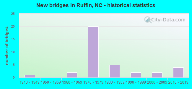
- New bridges - historical statistics
- 11940-1949
- 21960-1969
- 201970-1979
- 51980-1989
- 21990-1999
- 22000-2009
- 42010-2019


- Bridge Condition - Deck
- 33.3%Very good
- 16.7%Good
- 33.3%Satisfactory
- 16.7%Fair

- Bridge Condition - Superstructure
- 38.9%Very good
- 16.7%Good
- 11.1%Satisfactory
- 11.1%Fair
- 22.2%Poor

- Bridge Condition - Substructure
- 33.3%Very good
- 5.6%Good
- 22.2%Satisfactory
- 16.7%Fair
- 22.2%Poor

- Bridge Condition - Channel
- 8.3%Very good
- 66.7%Good
- 8.3%Satisfactory
- 8.3%Fair
- 8.3%Poor
Find on map >> Show street view
Structure Number: 330018, Location: 1.6 MI. E. JCT. SR1341 (Lat: 36.473653, Lng: -79.513694), Route carried "on" structure: State highway 1343, Year Built: 1981, Status: Open, Structure Length: 7.01m (23.00ft), Average Daily Traffic: 1,200 (year 2016), Truck Traffic: 6%, Average Future Daily Traffic: 2,400 (year 2040), Design Load: HS 20+Mod, Features Intersected: US29
Minimum Vertical Clearance: 30+ m (98+ ft), Kilometerpoint: 0.000, Lanes on structure: 2, Lanes under structure: 4, Owner: State Highway Agency, Approaching Roadway Width: 6.0m (19.7ft), Material/Design: Steel, Design/Construction: Stringer/Multi-beam, Number Of Spans In Main Unit: 2, Length of Maximum Span: 35.0m (114.8ft), Curb-To-Curb Width: 10.9m (35.8ft), Out-to-Out Width: 11.8m (38.7ft)
Condition: Deck: Satisfactory, Superstructure: Good, Substructure: Satisfactory, Operating Rating: 89.8 metric tons, Method Used To Determine Operating Rating: Load Factor (LF), Inventory Rating: 68.0 metric tons, Method Used To Determine Inventory Rating: Load Factor (LF), Structural Evaluation: Equal to present minimum criteria, Deck Geometry: Equal to present minimum criteria, Underclear: Equal to present minimum criteria, Approach Roadway Alignment: Equal to present desirable criteria, Designated Inspection Frequency: Every 24 months, Inspection Date: November 2021, Deck Structure Type: Concrete Cast-file-Place, Wearing Surface/Protective System: Wearing Surface: Monolithic Concrete
Find on map >> Show street view
Structure Number: 330046, Location: 0.6 MI. S. JCT. SR1300 (Lat: 36.425639, Lng: -79.470539), Route carried "on" structure: State highway 1303, Year Built: 2012, Status: Open, Structure Length: 3.44m (11.29ft), Average Daily Traffic: 180 (year 2015), Truck Traffic: 6%, Average Future Daily Traffic: 360 (year 2040), Design Load: HL 93, Features Intersected: MOON CREEK
Minimum Vertical Clearance: 30+ m (98+ ft), Kilometerpoint: 0.000, Lanes on structure: 2, Owner: State Highway Agency, Approaching Roadway Width: 7.6m (24.9ft), Material/Design: Prestressed concrete, Design/Construction: Slab, Number Of Spans In Main Unit: 3, Length of Maximum Span: 14.9m (48.9ft), Curb-To-Curb Width: 8.3m (27.2ft), Out-to-Out Width: 9.1m (29.9ft)
Condition: Deck: Very good, Superstructure: Very good, Substructure: Very good, Channel: Good, Operating Rating: 49.8 metric tons, Method Used To Determine Operating Rating: Load and Resistance Factor (LRFR), Inventory Rating: 38.1 metric tons, Method Used To Determine Inventory Rating: Load and Resistance Factor (LRFR), Structural Evaluation: Equal to present desirable criteria, Deck Geometry: Somewhat better than minimum adequacy, Waterway Adequacy: Better than present minimum criteria, Approach Roadway Alignment: Equal to present desirable criteria, Designated Inspection Frequency: Every 24 months, Inspection Date: November 2021, Deck Structure Type: Concrete Precast Panels, Wearing Surface/Protective System: Wearing Surface: Bituminous
Find on map >> Show street view
Structure Number: 330047, Location: 1.5 MI. N. JCT. SR1302 (Lat: 36.439192, Lng: -79.515208), Route carried "on" structure: State highway 1301, Year Built: 2013, Status: Open, Structure Length: 3.96m (12.99ft), Average Daily Traffic: 430 (year 2018), Truck Traffic: 6%, Average Future Daily Traffic: 860 (year 2040), Design Load: HL 93, Features Intersected: HOGAN'S CREEK
Minimum Vertical Clearance: 30+ m (98+ ft), Kilometerpoint: 0.000, Lanes on structure: 2, Owner: State Highway Agency, Approaching Roadway Width: 8.2m (26.9ft), Material/Design: Prestressed concrete, Design/Construction: Slab, Number Of Spans In Main Unit: 3, Length of Maximum Span: 20.7m (67.9ft), Curb-To-Curb Width: 8.1m (26.6ft), Out-to-Out Width: 9.1m (29.9ft)
Condition: Deck: Very good, Superstructure: Very good, Substructure: Very good, Channel: Good, Operating Rating: 48.9 metric tons, Method Used To Determine Operating Rating: Load and Resistance Factor (LRFR), Inventory Rating: 38.1 metric tons, Method Used To Determine Inventory Rating: Load and Resistance Factor (LRFR), Structural Evaluation: Equal to present desirable criteria, Deck Geometry: Somewhat better than minimum adequacy, Waterway Adequacy: Better than present minimum criteria, Approach Roadway Alignment: Equal to present desirable criteria, Designated Inspection Frequency: Every 24 months, Inspection Date: July 2021, Deck Structure Type: Concrete Precast Panels, Wearing Surface/Protective System: Wearing Surface: Bituminous
Find on map >> Show street view
Structure Number: 330057, Location: 0.7 MI. E. JCT. SR1343 (Lat: 36.501042, Lng: -79.504461), Route carried "on" structure: State highway 1345, Year Built: 1977, Status: Open, Structure Length: 0.79m (2.59ft), Average Daily Traffic: 300 (year 2019), Truck Traffic: 6%, Average Future Daily Traffic: 600 (year 2040), Design Load: HS 20+Mod, Features Intersected: WOLF ISLAND CREEK
Minimum Vertical Clearance: 30+ m (98+ ft), Kilometerpoint: 0.000, Lanes on structure: 2, Owner: State Highway Agency, Approaching Roadway Width: 5.4m (17.7ft), Skew: 1 degrees, Material/Design: Steel, Design/Construction: Culvert, Number Of Spans In Main Unit: 3, Length of Maximum Span: 2.1m (6.9ft)
Condition: Channel: Good, Culverts: Fair, Operating Rating: 89.8 metric tons, Method Used To Determine Operating Rating: Load and Resistance Factor (LRFR), Inventory Rating: 89.8 metric tons, Method Used To Determine Inventory Rating: Load and Resistance Factor (LRFR), Structural Evaluation: Somewhat better than minimum adequacy, Waterway Adequacy: Better than present minimum criteria, Approach Roadway Alignment: Equal to present desirable criteria, Designated Inspection Frequency: Every 24 months, Inspection Date: May 2021
Find on map >> Show street view
Structure Number: 1570079, Location: 0.85 MI. S. JCT. SR1929 (Lat: 36.429250, Lng: -79.597961), Route carried "on" structure: State highway 1931, Year Built: 1995, Status: Open, Structure Length: 3.10m (10.17ft), Average Daily Traffic: 95 (year 2000), Average Future Daily Traffic: 190 (year 2040), Design Load: HS 20+Mod, Features Intersected: WOLF ISLAND CREEK
Minimum Vertical Clearance: 30+ m (98+ ft), Kilometerpoint: 0.000, Lanes on structure: 2, Owner: State Highway Agency, Approaching Roadway Width: 6.0m (19.7ft), Material/Design: Prestressed concrete, Design/Construction: Slab, Number Of Spans In Main Unit: 3, Length of Maximum Span: 12.1m (39.7ft), Curb-To-Curb Width: 7.3m (24.0ft), Out-to-Out Width: 8.2m (26.9ft)
Condition: Deck: Good, Superstructure: Good, Substructure: Good, Channel: Good, Operating Rating: 79.8 metric tons, Method Used To Determine Operating Rating: Load Factor (LF), Inventory Rating: 47.1 metric tons, Method Used To Determine Inventory Rating: Load Factor (LF), Structural Evaluation: Better than present minimum criteria, Deck Geometry: Equal to present minimum criteria, Waterway Adequacy: Better than present minimum criteria, Approach Roadway Alignment: Equal to present desirable criteria, Designated Inspection Frequency: Every 24 months, Inspection Date: April 2021, Deck Structure Type: Concrete Precast Panels, Wearing Surface/Protective System: Wearing Surface: Bituminous
Find on map >> Show street view
Structure Number: 1570081, Location: 0.75 MI. N. JCT. SR2566 (Lat: 36.425553, Lng: -79.543883), Route carried "on" structure: State highway 2565, Year Built: 2013, Status: Open, Structure Length: 3.56m (11.68ft), Average Daily Traffic: 900 (year 2019), Truck Traffic: 6%, Average Future Daily Traffic: 1,800 (year 2040), Design Load: HL 93, Features Intersected: LICK FORK CREEK
Minimum Vertical Clearance: 30+ m (98+ ft), Kilometerpoint: 0.000, Lanes on structure: 2, Owner: State Highway Agency, Approaching Roadway Width: 8.2m (26.9ft), Material/Design: Prestressed concrete, Design/Construction: Slab, Number Of Spans In Main Unit: 2, Number Of Approach Spans: 2, Length of Maximum Span: 20.4m (66.9ft), Curb-To-Curb Width: 8.3m (27.2ft), Out-to-Out Width: 9.1m (29.9ft)
Condition: Deck: Very good, Superstructure: Very good, Substructure: Very good, Channel: Very good, Operating Rating: 56.2 metric tons, Method Used To Determine Operating Rating: Load and Resistance Factor (LRFR), Inventory Rating: 41.7 metric tons, Method Used To Determine Inventory Rating: Load and Resistance Factor (LRFR), Structural Evaluation: Equal to present desirable criteria, Deck Geometry: Somewhat better than minimum adequacy, Waterway Adequacy: Better than present minimum criteria, Approach Roadway Alignment: Equal to present desirable criteria, Designated Inspection Frequency: Every 24 months, Inspection Date: September 2020, Deck Structure Type: Concrete Precast Panels, Wearing Surface/Protective System: Wearing Surface: Bituminous
Find on map >> Show street view
Structure Number: 1570082, Location: 0.5MI. E. JCT.SR2577 (Lat: 36.402639, Lng: -79.581667), Route carried "on" structure: State highway 2552, Year Built: 1948, Status: Open, Structure Length: 1.06m (3.48ft), Average Daily Traffic: 360 (year 2018), Truck Traffic: 6%, Average Future Daily Traffic: 720 (year 2040), Features Intersected: LICK FORK CREEK
Minimum Vertical Clearance: 30+ m (98+ ft), Kilometerpoint: 0.000, Lanes on structure: 2, Owner: State Highway Agency, Approaching Roadway Width: 6.0m (19.7ft), Material/Design: Steel continuous, Design/Construction: Stringer/Multi-beam, Number Of Spans In Main Unit: 2, Length of Maximum Span: 5.1m (16.7ft), Curb or Sidewalk Widths: Left: 0.1m (0.3ft), Right: 0.1m (0.3ft), Curb-To-Curb Width: 6.6m (21.7ft), Out-to-Out Width: 7.4m (24.3ft)
Condition: Deck: Satisfactory, Superstructure: Fair, Substructure: Satisfactory, Channel: Satisfactory, Operating Rating: 81.6 metric tons, Method Used To Determine Operating Rating: Load Factor (LF), Inventory Rating: 48.9 metric tons, Method Used To Determine Inventory Rating: Load Factor (LF), Structural Evaluation: Somewhat better than minimum adequacy, Deck Geometry: Meets minimum limits, Waterway Adequacy: Better than present minimum criteria, Approach Roadway Alignment: Equal to present desirable criteria, Designated Inspection Frequency: Every 24 months, Inspection Date: April 2021, Deck Structure Type: Concrete Cast-file-Place, Wearing Surface/Protective System: Wearing Surface: Bituminous
Find on map >> Show street view
Structure Number: 1570096, Location: 1.3 MI. S. JCT. US158 (Lat: 36.374039, Lng: -79.552372), Route carried "on" structure: State highway 2571, Year Built: 2008, Status: Open, Structure Length: 3.87m (12.70ft), Average Daily Traffic: 1,500 (year 2018), Truck Traffic: 6%, Average Future Daily Traffic: 3,000 (year 2040), Design Load: HS 20+Mod, Features Intersected: JONES CREEK
Minimum Vertical Clearance: 30+ m (98+ ft), Kilometerpoint: 0.000, Lanes on structure: 2, Owner: State Highway Agency, Approaching Roadway Width: 9.4m (30.8ft), Skew: 1 degrees, Material/Design: Prestressed concrete, Design/Construction: Slab, Number Of Spans In Main Unit: 3, Length of Maximum Span: 14.6m (47.9ft), Curb-To-Curb Width: 9.1m (29.9ft), Out-to-Out Width: 10.0m (32.8ft)
Condition: Deck: Very good, Superstructure: Very good, Substructure: Very good, Channel: Good, Operating Rating: 80.7 metric tons, Method Used To Determine Operating Rating: Load Factor (LF), Inventory Rating: 48.0 metric tons, Method Used To Determine Inventory Rating: Load Factor (LF), Structural Evaluation: Equal to present desirable criteria, Deck Geometry: Somewhat better than minimum adequacy, Waterway Adequacy: Better than present minimum criteria, Approach Roadway Alignment: Equal to present desirable criteria, Designated Inspection Frequency: Every 24 months, Inspection Date: April 2021, Deck Structure Type: Concrete Precast Panels, Wearing Surface/Protective System: Wearing Surface: Bituminous
Find on map >> Show street view
Structure Number: 1570097, Location: 1.7 MI. W. JCT. US29 (Lat: 36.456603, Lng: -79.569719), Route carried "on" structure: State highway 1925, Year Built: 2016, Status: Open, Structure Length: 6.00m (19.69ft), Average Daily Traffic: 700 (year 2018), Truck Traffic: 6%, Average Future Daily Traffic: 1,400 (year 2040), Design Load: HL 93, Features Intersected: WOLF ISLAND CREEK
Minimum Vertical Clearance: 30+ m (98+ ft), Kilometerpoint: 0.000, Lanes on structure: 2, Owner: State Highway Agency, Approaching Roadway Width: 9.1m (29.9ft), Material/Design: Prestressed concrete, Design/Construction: Box Beam or Girders - Multiple, Number Of Spans In Main Unit: 2, Length of Maximum Span: 30.1m (98.8ft), Curb-To-Curb Width: 9.0m (29.5ft), Out-to-Out Width: 10.0m (32.8ft)
Condition: Deck: Very good, Superstructure: Very good, Substructure: Very good, Operating Rating: 73.4 metric tons, Method Used To Determine Operating Rating: Load and Resistance Factor (LRFR), Inventory Rating: 46.2 metric tons, Method Used To Determine Inventory Rating: Load and Resistance Factor (LRFR), Structural Evaluation: Equal to present desirable criteria, Deck Geometry: Somewhat better than minimum adequacy, Approach Roadway Alignment: Equal to present desirable criteria, Designated Inspection Frequency: Every 24 months, Inspection Date: April 2020, Deck Structure Type: Concrete Precast Panels, Wearing Surface/Protective System: Wearing Surface: Bituminous, Deck Protection: Epoxy Coated Reinforcing
Find on map >> Show street view
Structure Number: 1570103, Location: 0.8 MI. S. JCT. NC700 (Lat: 36.489606, Lng: -79.600122), Route carried "on" structure: State highway 1910, Year Built: 1994, Status: Open, Structure Length: 0.73m (2.40ft), Average Daily Traffic: 130 (year 2001), Truck Traffic: 6%, Average Future Daily Traffic: 260 (year 2040), Design Load: HS 20+Mod, Features Intersected: BIRCH FORK CREEK
Minimum Vertical Clearance: 30+ m (98+ ft), Kilometerpoint: 0.000, Lanes on structure: 2, Owner: State Highway Agency, Approaching Roadway Width: 5.4m (17.7ft), Material/Design: Steel, Design/Construction: Culvert, Number Of Spans In Main Unit: 2, Length of Maximum Span: 3.3m (10.8ft)
Condition: Channel: Good, Culverts: Fair, Operating Rating: 89.8 metric tons, Method Used To Determine Operating Rating: Load and Resistance Factor (LRFR), Inventory Rating: 89.8 metric tons, Method Used To Determine Inventory Rating: Load and Resistance Factor (LRFR), Structural Evaluation: Somewhat better than minimum adequacy, Waterway Adequacy: Better than present minimum criteria, Approach Roadway Alignment: Equal to present desirable criteria, Designated Inspection Frequency: Every 24 months, Inspection Date: April 2021
Find on map >> Show street view
Structure Number: 1570106, Location: 2.3 MI. N. JCT. US29 (Lat: 36.498422, Lng: -79.541725), Route carried "on" structure: State highway 1902, Year Built: 1962, Status: Posted for load, Structure Length: 5.51m (18.08ft), Average Daily Traffic: 150 (year 2012), Truck Traffic: 6%, Average Future Daily Traffic: 300 (year 2040), Design Load: H 10, Features Intersected: WOLF ISLAND CREEK
Minimum Vertical Clearance: 30+ m (98+ ft), Kilometerpoint: 0.000, Lanes on structure: 2, Owner: State Highway Agency, Approaching Roadway Width: 6.0m (19.7ft), Material/Design: Prestressed concrete, Design/Construction: Channel Beam, Number Of Spans In Main Unit: 6, Length of Maximum Span: 8.8m (28.9ft), Curb or Sidewalk Widths: Left: 0.1m (0.3ft), Right: 0.1m (0.3ft), Curb-To-Curb Width: 7.2m (23.6ft), Out-to-Out Width: 7.7m (25.3ft)
Condition: Deck: Fair, Superstructure: Poor, Substructure: Poor, Channel: Fair, Operating Rating: 36.2 metric tons, Method Used To Determine Operating Rating: Load Factor (LF), Inventory Rating: 18.1 metric tons, Method Used To Determine Inventory Rating: Load Factor (LF), Structural Evaluation: Meets minimum limits, Deck Geometry: Meets minimum limits, Waterway Adequacy: Better than present minimum criteria, Approach Roadway Alignment: Equal to present desirable criteria, Bridge Posting: Required (Relationship of Operating Rating to Maximum Legal Load: 0.1 - 9.9% below), Designated Inspection Frequency: Every 24 months, Inspection Date: January 2022, Deck Structure Type: Concrete Cast-file-Place, Wearing Surface/Protective System: Wearing Surface: Bituminous
Find on map >> Show street view
Structure Number: 1570109, Location: 0.7 MI. S. JCT. SR1906 (Lat: 36.488097, Lng: -79.558944), Route carried "on" structure: State highway 1767, Year Built: 2009, Status: Open, Structure Length: 2.89m (9.48ft), Average Daily Traffic: 400 (year 2018), Truck Traffic: 6%, Average Future Daily Traffic: 800 (year 2040), Design Load: HS 25 or greater, Features Intersected: BIRCH FORK CREEK
Minimum Vertical Clearance: 30+ m (98+ ft), Kilometerpoint: 0.000, Lanes on structure: 2, Owner: State Highway Agency, Approaching Roadway Width: 7.9m (25.9ft), Skew: 2 degrees, Material/Design: Prestressed concrete, Design/Construction: Box Beam or Girders - Multiple, Number Of Spans In Main Unit: 1, Length of Maximum Span: 27.7m (90.9ft), Curb-To-Curb Width: 8.3m (27.2ft), Out-to-Out Width: 9.1m (29.9ft)
Condition: Deck: Very good, Superstructure: Very good, Substructure: Very good, Channel: Good, Operating Rating: 89.8 metric tons, Method Used To Determine Operating Rating: Load Factor (LF), Inventory Rating: 70.7 metric tons, Method Used To Determine Inventory Rating: Load Factor (LF), Structural Evaluation: Equal to present desirable criteria, Deck Geometry: Somewhat better than minimum adequacy, Waterway Adequacy: Better than present minimum criteria, Approach Roadway Alignment: Equal to present desirable criteria, Designated Inspection Frequency: Every 24 months, Inspection Date: April 2021, Deck Structure Type: Concrete Precast Panels, Wearing Surface/Protective System: Wearing Surface: Bituminous, Deck Protection: Epoxy Coated Reinforcing
Find on map >> Show street view
Structure Number: 1570135, Location: 0.5 MI. W. JCT. SR2577 (Lat: 36.401008, Lng: -79.597625), Route carried "on" structure: State highway 2552, Year Built: 1970, Status: Open, Structure Length: 8.56m (28.08ft), Average Daily Traffic: 600 (year 2016), Truck Traffic: 6%, Average Future Daily Traffic: 1,200 (year 2040), Design Load: HS 15, Features Intersected: US29
Minimum Vertical Clearance: 30+ m (98+ ft), Kilometerpoint: 0.000, Lanes on structure: 2, Lanes under structure: 5, Owner: State Highway Agency, Approaching Roadway Width: 7.0m (23.0ft), Skew: 2 degrees, Material/Design: Steel continuous, Design/Construction: Stringer/Multi-beam, Number Of Spans In Main Unit: 4, Length of Maximum Span: 32.6m (107.0ft), Curb-To-Curb Width: 10.9m (35.8ft), Out-to-Out Width: 11.5m (37.7ft)
Condition: Deck: Satisfactory, Superstructure: Good, Substructure: Fair, Operating Rating: 61.6 metric tons, Method Used To Determine Operating Rating: Load Factor (LF), Inventory Rating: 37.1 metric tons, Method Used To Determine Inventory Rating: Load Factor (LF), Structural Evaluation: Somewhat better than minimum adequacy, Deck Geometry: Equal to present minimum criteria, Underclear: Better than present minimum criteria, Approach Roadway Alignment: Equal to present desirable criteria, Designated Inspection Frequency: Every 24 months, Inspection Date: April 2021, Deck Structure Type: Concrete Cast-file-Place, Wearing Surface/Protective System: Wearing Surface: Monolithic Concrete
Find on map >> Show street view
Structure Number: 1570152, Location: 0.7MI. S. JCT. SR1929 (Lat: 36.434375, Lng: -79.572586), Route carried "on" structure: Business US 29, Year Built: 1970, Status: Open, Structure Length: 6.58m (21.59ft), Average Daily Traffic: 1,800 (year 2018), Truck Traffic: 8%, Average Future Daily Traffic: 3,600 (year 2040), Design Load: HS 20+Mod, Features Intersected: US29
Minimum Vertical Clearance: 30+ m (98+ ft), Kilometerpoint: 48.433, Lanes on structure: 2, Lanes under structure: 6, Owner: State Highway Agency, Approaching Roadway Width: 10.9m (35.8ft), Skew: 21 degrees, Material/Design: Steel continuous, Design/Construction: Stringer/Multi-beam, Number Of Spans In Main Unit: 4, Length of Maximum Span: 21.6m (70.9ft), Curb-To-Curb Width: 17.0m (55.8ft), Out-to-Out Width: 17.6m (57.7ft)
Condition: Deck: Satisfactory, Superstructure: Satisfactory, Substructure: Satisfactory, Operating Rating: 87.9 metric tons, Method Used To Determine Operating Rating: Load Factor (LF), Inventory Rating: 52.6 metric tons, Method Used To Determine Inventory Rating: Load Factor (LF), Structural Evaluation: Equal to present minimum criteria, Deck Geometry: Superior to present desirable criteria, Underclear: Equal to present minimum criteria, Approach Roadway Alignment: Equal to present desirable criteria, Designated Inspection Frequency: Every 24 months, Inspection Date: April 2021, Deck Structure Type: Concrete Cast-file-Place, Wearing Surface/Protective System: Wearing Surface: Epoxy Overlay
Find on map >> Show street view
Structure Number: 1570156, Location: 0.5 MI. E. JCT. SR2556 (Lat: 36.426697, Lng: -79.573256), Route carried "on" structure: State highway 2557, Year Built: 1970, Status: Open, Structure Length: 7.52m (24.67ft), Average Daily Traffic: 60 (year 2015), Average Future Daily Traffic: 120 (year 2040), Features Intersected: US29
Minimum Vertical Clearance: 30+ m (98+ ft), Kilometerpoint: 0.000, Lanes on structure: 2, Lanes under structure: 4, Owner: State Highway Agency, Approaching Roadway Width: 6.0m (19.7ft), Skew: 1 degrees, Material/Design: Steel continuous, Design/Construction: Stringer/Multi-beam, Number Of Spans In Main Unit: 4, Length of Maximum Span: 24.3m (79.7ft), Curb-To-Curb Width: 9.1m (29.9ft), Out-to-Out Width: 9.7m (31.8ft)
Condition: Deck: Good, Superstructure: Very good, Substructure: Satisfactory, Operating Rating: 49.8 metric tons, Method Used To Determine Operating Rating: Load Factor (LF), Inventory Rating: 29.0 metric tons, Method Used To Determine Inventory Rating: Load Factor (LF), Structural Evaluation: Equal to present minimum criteria, Deck Geometry: Better than present minimum criteria, Underclear: Equal to present minimum criteria, Approach Roadway Alignment: Equal to present desirable criteria, Designated Inspection Frequency: Every 24 months, Inspection Date: April 2021, Deck Structure Type: Concrete Cast-file-Place, Wearing Surface/Protective System: Wearing Surface: Monolithic Concrete, Deck Protection: Epoxy Coated Reinforcing
Find on map >> Show street view
Structure Number: 1570163, Location: 1.1 MI. E. JCT. SR2569 (Lat: 36.398619, Lng: -79.529794), Route carried "on" structure: US 158, Year Built: 1967, Status: Open, Structure Length: 5.33m (17.49ft), Average Daily Traffic: 2,300 (year 2015), Truck Traffic: 14%, Average Future Daily Traffic: 4,600 (year 2040), Design Load: HS 20, Features Intersected: HOGAN'S CREEK
Minimum Vertical Clearance: 30+ m (98+ ft), Kilometerpoint: 0.000, Lanes on structure: 2, Base Highway Network: Yes (Inventory Route: 2, Subroute: 58), Owner: State Highway Agency, Approaching Roadway Width: 8.2m (26.9ft), Skew: 2 degrees, Material/Design: Steel, Design/Construction: Stringer/Multi-beam, Number Of Spans In Main Unit: 5, Length of Maximum Span: 10.3m (33.8ft), Curb-To-Curb Width: 10.8m (35.4ft), Out-to-Out Width: 11.7m (38.4ft)
Condition: Deck: Satisfactory, Superstructure: Poor, Substructure: Poor, Channel: Poor, Operating Rating: 53.5 metric tons, Method Used To Determine Operating Rating: Load Factor (LF), Inventory Rating: 31.7 metric tons, Method Used To Determine Inventory Rating: Load Factor (LF), Structural Evaluation: Meets minimum limits, Deck Geometry: Somewhat better than minimum adequacy, Waterway Adequacy: Better than present minimum criteria, Approach Roadway Alignment: Equal to present desirable criteria, Designated Inspection Frequency: Every 24 months, Underwater Inspection Frequency: Every 60 months, Inspection Date: January 2022, Underwater Inspection Date: May 2019, Deck Structure Type: Concrete Cast-file-Place, Wearing Surface/Protective System: Wearing Surface: Bituminous
Find on map >> Show street view
Structure Number: 1570178, Location: 0.4 MI. W. JCT. US29BUS (Lat: 36.443656, Lng: -79.568906), Route carried "on" structure: State highway 1929, Year Built: 1970, Status: Temporarily open, Structure Length: 8.01m (26.28ft), Average Daily Traffic: 230 (year 2016), Truck Traffic: 6%, Average Future Daily Traffic: 460 (year 2040), Design Load: HS 15, Features Intersected: US29
Minimum Vertical Clearance: 30+ m (98+ ft), Kilometerpoint: 45.842, Lanes on structure: 2, Lanes under structure: 4, Owner: State Highway Agency, Approaching Roadway Width: 6.0m (19.7ft), Skew: 2 degrees, Material/Design: Steel, Design/Construction: Stringer/Multi-beam, Number Of Spans In Main Unit: 4, Length of Maximum Span: 27.4m (89.9ft), Curb-To-Curb Width: 10.9m (35.8ft), Out-to-Out Width: 11.5m (37.7ft)
Condition: Deck: Fair, Superstructure: Poor, Substructure: Poor, Operating Rating: 49.8 metric tons, Method Used To Determine Operating Rating: Load Factor (LF), Inventory Rating: 29.9 metric tons, Method Used To Determine Inventory Rating: Load Factor (LF), Structural Evaluation: Meets minimum limits, Deck Geometry: Better than present minimum criteria, Underclear: Better than present minimum criteria, Approach Roadway Alignment: Equal to present desirable criteria, Designated Inspection Frequency: Every 24 months, Inspection Date: January 2022, Deck Structure Type: Concrete Cast-file-Place, Wearing Surface/Protective System: Wearing Surface: Bituminous
Find on map >> Show street view
Structure Number: 1570182, Location: 1.0 MI. W. JCT. US29BUS (Lat: 36.450164, Lng: -79.556567), Route carried "on" structure: State highway 1925, Year Built: 1970, Status: Open, Structure Length: 7.28m (23.88ft), Average Daily Traffic: 7,500 (year 2017), Truck Traffic: 6%, Average Future Daily Traffic: 15,000 (year 2040), Design Load: HS 15, Features Intersected: US29
Minimum Vertical Clearance: 30+ m (98+ ft), Kilometerpoint: 0.000, Lanes on structure: 2, Lanes under structure: 4, Owner: State Highway Agency, Approaching Roadway Width: 7.9m (25.9ft), Skew: 1 degrees, Material/Design: Steel continuous, Design/Construction: Stringer/Multi-beam, Number Of Spans In Main Unit: 4, Length of Maximum Span: 24.9m (81.7ft), Curb-To-Curb Width: 10.9m (35.8ft), Out-to-Out Width: 11.5m (37.7ft)
Condition: Deck: Good, Superstructure: Fair, Substructure: Fair, Operating Rating: 62.5 metric tons, Method Used To Determine Operating Rating: Load Factor (LF), Inventory Rating: 37.1 metric tons, Method Used To Determine Inventory Rating: Load Factor (LF), Structural Evaluation: Somewhat better than minimum adequacy, Deck Geometry: Meets minimum limits, Underclear: Equal to present minimum criteria, Approach Roadway Alignment: Equal to present desirable criteria, Designated Inspection Frequency: Every 24 months, Inspection Date: April 2021, Deck Structure Type: Concrete Cast-file-Place, Wearing Surface/Protective System: Wearing Surface: Monolithic Concrete
Find on map >> Show street view
Structure Number: 1570183, Location: 0.65 MI. N. JCT. SR1925 (Lat: 36.456144, Lng: -79.543594), Route carried "on" structure: Business US 29, Year Built: 1970, Status: Temporarily open, Structure Length: 6.94m (22.77ft), Average Daily Traffic: 6,750 (year 2018), Truck Traffic: 8%, Average Future Daily Traffic: 13,500 (year 2040), Design Load: HS 15, Features Intersected: US29 BYP.
Minimum Vertical Clearance: 30+ m (98+ ft), Kilometerpoint: 0.000, Lanes on structure: 2, Lanes under structure: 4, Owner: State Highway Agency, Approaching Roadway Width: 7.3m (24.0ft), Material/Design: Steel, Design/Construction: Stringer/Multi-beam, Number Of Spans In Main Unit: 4, Length of Maximum Span: 23.7m (77.8ft), Curb-To-Curb Width: 10.9m (35.8ft), Out-to-Out Width: 11.5m (37.7ft)
Condition: Deck: Fair, Superstructure: Poor, Substructure: Poor, Operating Rating: 49.8 metric tons, Method Used To Determine Operating Rating: Load Factor (LF), Inventory Rating: 29.9 metric tons, Method Used To Determine Inventory Rating: Load Factor (LF), Structural Evaluation: Meets minimum limits, Deck Geometry: Meets minimum limits, Underclear: Better than present minimum criteria, Approach Roadway Alignment: Equal to present desirable criteria, Designated Inspection Frequency: Every 24 months, Inspection Date: January 2022, Deck Structure Type: Concrete Cast-file-Place, Wearing Surface/Protective System: Wearing Surface: Monolithic Concrete
Find on map >> Show street view
Structure Number: 1570254, Location: 0.6 MI.S.JCT.NC700 (Lat: 36.517225, Lng: -79.521006), Route carried "on" structure: State highway 1900, Year Built: 1977, Status: Open, Structure Length: 4.11m (13.48ft), Average Daily Traffic: 300 (year 2015), Truck Traffic: 6%, Average Future Daily Traffic: 600 (year 2040), Design Load: HS 15, Features Intersected: WOLF ISLAND CREEK
Minimum Vertical Clearance: 30+ m (98+ ft), Kilometerpoint: 0.000, Lanes on structure: 2, Owner: State Highway Agency, Approaching Roadway Width: 8.2m (26.9ft), Material/Design: Prestressed concrete, Design/Construction: Slab, Number Of Spans In Main Unit: 3, Length of Maximum Span: 13.4m (44.0ft), Curb-To-Curb Width: 8.9m (29.2ft), Out-to-Out Width: 9.2m (30.2ft)
Condition: Deck: Satisfactory, Superstructure: Satisfactory, Substructure: Fair, Channel: Good, Operating Rating: 48.0 metric tons, Method Used To Determine Operating Rating: Load Factor (LF), Inventory Rating: 29.0 metric tons, Method Used To Determine Inventory Rating: Load Factor (LF), Structural Evaluation: Somewhat better than minimum adequacy, Deck Geometry: Equal to present minimum criteria, Waterway Adequacy: Better than present minimum criteria, Approach Roadway Alignment: Equal to present desirable criteria, Designated Inspection Frequency: Every 24 months, Inspection Date: April 2021, Deck Structure Type: Concrete Precast Panels, Wearing Surface/Protective System: Wearing Surface: Bituminous
Find on map >> Show street view
Structure Number: 330018, Location: 1.6 MI. E. JCT. SR1341 (Lat: 36.473653, Lng: -79.513694), Route carried "under" structure: US 29, Year Built: 1981, Structure Length: 0. m, Average Daily Traffic: 6,750 (year 2018), Truck Traffic: 14%, Features Intersected: SR1343
Minimum Vertical Clearance: 5.00m (16.40ft), Kilometerpoint: 49.743, Lanes on structure: 2, Lanes under structure: 2, Material/Design: Steel, Design/Construction: Stringer/Multi-beam, Length of Maximum Span: 35.0m (114.8ft)
Find on map >> Show street view
Structure Number: 330018, Location: 1.6 MI. E. JCT. SR1341 (Lat: 36.473653, Lng: -79.513694), Route carried "under" structure: US 29, Year Built: 1981, Structure Length: 0. m, Average Daily Traffic: 6,750 (year 2018), Truck Traffic: 14%, Features Intersected: SR1343
Minimum Vertical Clearance: 5.10m (16.73ft), Kilometerpoint: 49.743, Lanes on structure: 2, Lanes under structure: 2, Material/Design: Steel, Design/Construction: Stringer/Multi-beam, Length of Maximum Span: 35.0m (114.8ft)
Find on map >> Show street view
Structure Number: 33005, Location: 0.17 MI. E. JCT. SR1347 (Lat: 36.486700, Lng: -79.490842), Route carried "under" structure: US 29, Year Built: 1981, Structure Length: 0. m, Average Daily Traffic: 8,250 (year 2019), Truck Traffic: 14%, Features Intersected: SR1341
Minimum Vertical Clearance: 4.92m (16.14ft), Kilometerpoint: 50.262, Lanes on structure: 2, Lanes under structure: 2, Material/Design: Steel, Design/Construction: Stringer/Multi-beam, Length of Maximum Span: 39.3m (128.9ft)
Find on map >> Show street view
Structure Number: 33005, Location: 0.17 MI. E. JCT. SR1347 (Lat: 36.486700, Lng: -79.490842), Route carried "under" structure: US 29, Year Built: 1981, Structure Length: 0. m, Average Daily Traffic: 8,250 (year 2019), Truck Traffic: 14%, Features Intersected: SR1341
Minimum Vertical Clearance: 5.86m (19.23ft), Kilometerpoint: 50.262, Lanes on structure: 2, Lanes under structure: 2, Material/Design: Steel, Design/Construction: Stringer/Multi-beam, Length of Maximum Span: 39.3m (128.9ft)
Find on map >> Show street view
Structure Number: 1570135, Location: 0.5 MI. W. JCT. SR2577 (Lat: 36.401008, Lng: -79.597625), Route carried "under" structure: Bypass US 29, Year Built: 1970, Structure Length: 0. m, Average Daily Traffic: 7,000 (year 2018), Truck Traffic: 14%, Features Intersected: SR2552
Minimum Vertical Clearance: 5.28m (17.32ft), Kilometerpoint: 47.579, Lanes on structure: 2, Lanes under structure: 2, Material/Design: Steel continuous, Design/Construction: Stringer/Multi-beam, Length of Maximum Span: 32.6m (107.0ft)
Find on map >> Show street view
Structure Number: 1570135, Location: 0.5 MI. W. JCT. SR2577 (Lat: 36.401008, Lng: -79.597625), Route carried "under" structure: Bypass US 29, Year Built: 1970, Structure Length: 0. m, Average Daily Traffic: 7,000 (year 2018), Truck Traffic: 14%, Features Intersected: SR2552
Minimum Vertical Clearance: 4.78m (15.68ft), Kilometerpoint: 47.579, Lanes on structure: 2, Lanes under structure: 3, Material/Design: Steel continuous, Design/Construction: Stringer/Multi-beam, Length of Maximum Span: 32.6m (107.0ft)
Find on map >> Show street view
Structure Number: 1570152, Location: 0.7MI. S. JCT. SR1929 (Lat: 36.434375, Lng: -79.572586), Route carried "under" structure: Bypass US 29, Year Built: 1970, Structure Length: 0. m, Average Daily Traffic: 6,250 (year 2018), Truck Traffic: 14%, Features Intersected: US29BUS
Minimum Vertical Clearance: 4.85m (15.91ft), Kilometerpoint: 48.433, Lanes on structure: 2, Lanes under structure: 3, Material/Design: Steel continuous, Design/Construction: Stringer/Multi-beam, Length of Maximum Span: 21.6m (70.9ft)
Find on map >> Show street view
Structure Number: 1570152, Location: 0.7MI. S. JCT. SR1929 (Lat: 36.434375, Lng: -79.572586), Route carried "under" structure: Bypass US 29, Year Built: 1970, Structure Length: 0. m, Average Daily Traffic: 6,250 (year 2018), Truck Traffic: 14%, Features Intersected: US29BUS
Minimum Vertical Clearance: 4.97m (16.31ft), Kilometerpoint: 48.433, Lanes on structure: 2, Lanes under structure: 3, Material/Design: Steel continuous, Design/Construction: Stringer/Multi-beam, Length of Maximum Span: 21.6m (70.9ft)
Find on map >> Show street view
Structure Number: 1570156, Location: 0.5 MI. E. JCT. SR2556 (Lat: 36.426697, Lng: -79.573256), Route carried "under" structure: US 29, Year Built: 1970, Structure Length: 0. m, Average Daily Traffic: 6,250 (year 2018), Truck Traffic: 14%, Features Intersected: SR2557
Minimum Vertical Clearance: 6.47m (21.23ft), Kilometerpoint: 48.250, Lanes on structure: 2, Lanes under structure: 2, Material/Design: Steel continuous, Design/Construction: Stringer/Multi-beam, Length of Maximum Span: 24.3m (79.7ft)
Find on map >> Show street view
Structure Number: 1570156, Location: 0.5 MI. E. JCT. SR2556 (Lat: 36.426697, Lng: -79.573256), Route carried "under" structure: US 29, Year Built: 1970, Structure Length: 0. m, Average Daily Traffic: 6,250 (year 2018), Truck Traffic: 14%, Features Intersected: SR2557
Minimum Vertical Clearance: 5.08m (16.67ft), Kilometerpoint: 48.250, Lanes on structure: 2, Lanes under structure: 2, Material/Design: Steel continuous, Design/Construction: Stringer/Multi-beam, Length of Maximum Span: 24.3m (79.7ft)
Find on map >> Show street view
Structure Number: 1570178, Location: 0.4 MI. W. JCT. US29BUS (Lat: 36.443656, Lng: -79.568906), Route carried "under" structure: Bypass US 29, Year Built: 1970, Structure Length: 0. m, Average Daily Traffic: 7,500 (year 2017), Truck Traffic: 14%, Features Intersected: SR1929
Minimum Vertical Clearance: 5.05m (16.57ft), Kilometerpoint: 0.000, Lanes on structure: 2, Lanes under structure: 2, Material/Design: Steel, Design/Construction: Stringer/Multi-beam, Length of Maximum Span: 27.4m (89.9ft)
Find on map >> Show street view
Structure Number: 1570178, Location: 0.4 MI. W. JCT. US29BUS (Lat: 36.443656, Lng: -79.568906), Route carried "under" structure: Bypass US 29, Year Built: 1970, Structure Length: 0. m, Average Daily Traffic: 7,500 (year 2017), Truck Traffic: 14%, Features Intersected: SR1929
Minimum Vertical Clearance: 5.79m (19.00ft), Kilometerpoint: 0.000, Lanes on structure: 2, Lanes under structure: 2, Material/Design: Steel, Design/Construction: Stringer/Multi-beam, Length of Maximum Span: 27.4m (89.9ft)
Find on map >> Show street view
Structure Number: 1570182, Location: 1.0 MI. W. JCT. US29BUS (Lat: 36.450164, Lng: -79.556567), Route carried "under" structure: US 29, Year Built: 1970, Structure Length: 0. m, Average Daily Traffic: 7,500 (year 2017), Truck Traffic: 14%, Features Intersected: SR1925
Minimum Vertical Clearance: 4.82m (15.81ft), Kilometerpoint: 48.920, Lanes on structure: 2, Lanes under structure: 2, Material/Design: Steel continuous, Design/Construction: Stringer/Multi-beam, Length of Maximum Span: 24.9m (81.7ft)
Find on map >> Show street view
Structure Number: 1570182, Location: 1.0 MI. W. JCT. US29BUS (Lat: 36.450164, Lng: -79.556567), Route carried "under" structure: US 29, Year Built: 1970, Structure Length: 0. m, Average Daily Traffic: 7,500 (year 2017), Truck Traffic: 14%, Features Intersected: SR1925
Minimum Vertical Clearance: 5.30m (17.39ft), Kilometerpoint: 48.920, Lanes on structure: 2, Lanes under structure: 2, Material/Design: Steel continuous, Design/Construction: Stringer/Multi-beam, Length of Maximum Span: 24.9m (81.7ft)
Find on map >> Show street view
Structure Number: 1570183, Location: 0.65 MI. N. JCT. SR1925 (Lat: 36.456144, Lng: -79.543594), Route carried "under" structure: Bypass US 29, Year Built: 1970, Structure Length: 0. m, Average Daily Traffic: 6,750 (year 2018), Truck Traffic: 14%, Features Intersected: US29BUS
Minimum Vertical Clearance: 4.77m (15.65ft), Kilometerpoint: 0.000, Lanes on structure: 2, Lanes under structure: 2, Material/Design: Steel, Design/Construction: Stringer/Multi-beam, Length of Maximum Span: 23.7m (77.8ft)
Find on map >> Show street view
Structure Number: 1570183, Location: 0.65 MI. N. JCT. SR1925 (Lat: 36.456144, Lng: -79.543594), Route carried "under" structure: Bypass US 29, Year Built: 1970, Structure Length: 0. m, Average Daily Traffic: 6,750 (year 2018), Truck Traffic: 14%, Features Intersected: US29BUS
Minimum Vertical Clearance: 4.81m (15.78ft), Kilometerpoint: 0.000, Lanes on structure: 2, Lanes under structure: 2, Material/Design: Steel, Design/Construction: Stringer/Multi-beam, Length of Maximum Span: 23.7m (77.8ft)