Bridge Statistics for Rural Hall, North Carolina (NC)
Condition, Traffic, Stress, Structural Evaluation, Project Costs
- National Bridge Inventory (NBI) Statistics
- 13Number of bridges
- 92ft / 27.8mTotal length
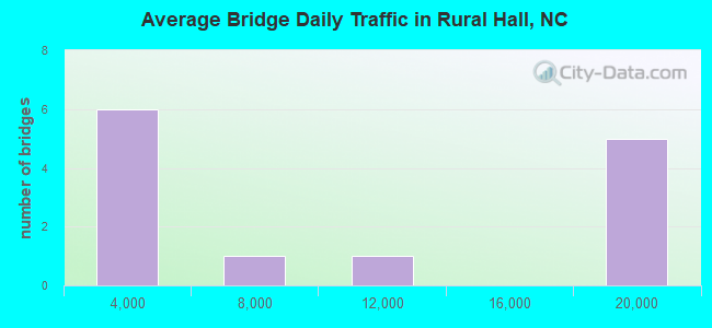
- 113,170Total average daily traffic
- 11,406Total average daily truck traffic
- National Bridge Inventory (NBI) Registered Bridges for Rural Hall
- No street view available for this location
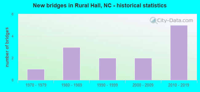
- New bridges - historical statistics
- 11970-1979
- 31980-1989
- 21990-1999
- 22000-2009
- 52010-2019
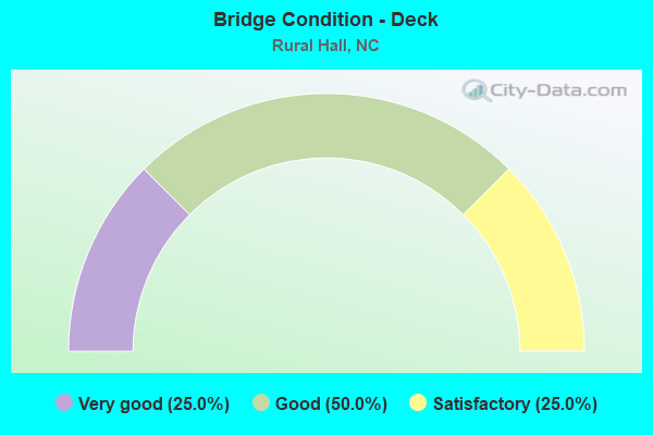
- Bridge Condition - Deck
- 25.0%Very good
- 50.0%Good
- 25.0%Satisfactory
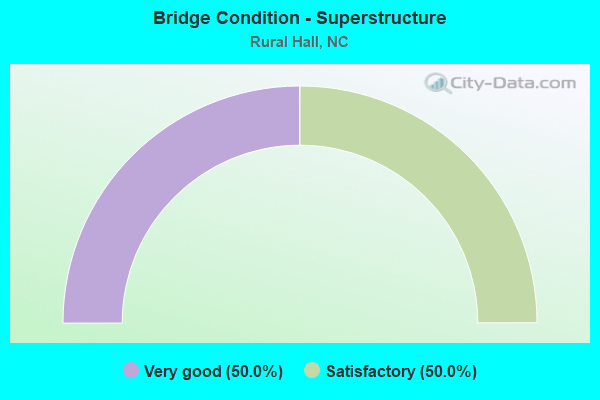
- Bridge Condition - Superstructure
- 50.0%Very good
- 50.0%Satisfactory
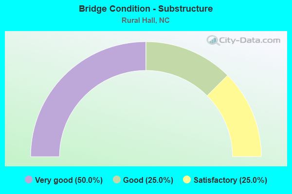
- Bridge Condition - Substructure
- 50.0%Very good
- 25.0%Good
- 25.0%Satisfactory
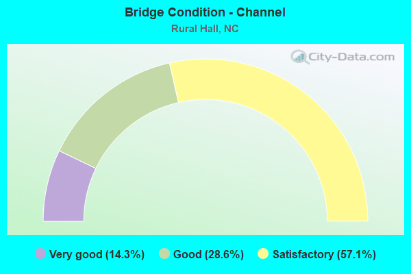
- Bridge Condition - Channel
- 14.3%Very good
- 28.6%Good
- 57.1%Satisfactory
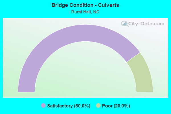
- Bridge Condition - Culverts
- 80.0%Satisfactory
- 20.0%Poor
Find on map >> Show street view
Structure Number: 67003, Location: 1.1 MI. W. JCT. NC65 (Lat: 36.209792, Lng: -80.324139), Route carried "on" structure: State highway 1631, Year Built: 2008, Status: Open, Structure Length: 3.04m (9.97ft), Average Daily Traffic: 1,600 (year 2013), Truck Traffic: 7%, Average Future Daily Traffic: 3,200 (year 2040), Design Load: HS 20+Mod, Features Intersected: MUDDY CREEK
Minimum Vertical Clearance: 30+ m (98+ ft), Kilometerpoint: 0.000, Lanes on structure: 2, Owner: State Highway Agency, Approaching Roadway Width: 9.1m (29.9ft), Material/Design: Prestressed concrete, Design/Construction: Box Beam or Girders - Multiple, Number Of Spans In Main Unit: 1, Length of Maximum Span: 29.2m (95.8ft), Curb-To-Curb Width: 9.0m (29.5ft), Out-to-Out Width: 10.0m (32.8ft)
Condition: Deck: Very good, Superstructure: Very good, Substructure: Very good, Channel: Good, Operating Rating: 89.8 metric tons, Method Used To Determine Operating Rating: Load Factor (LF), Inventory Rating: 79.8 metric tons, Method Used To Determine Inventory Rating: Load Factor (LF), Structural Evaluation: Equal to present desirable criteria, Deck Geometry: Somewhat better than minimum adequacy, Waterway Adequacy: Better than present minimum criteria, Approach Roadway Alignment: Equal to present desirable criteria, Designated Inspection Frequency: Every 24 months, Inspection Date: August 2020, Deck Structure Type: Concrete Precast Panels, Wearing Surface/Protective System: Wearing Surface: Bituminous
Find on map >> Show street view
Structure Number: 670036, Location: 0.2 MI. E. JCT. SR1632 (Lat: 36.210656, Lng: -80.303256), Route carried "on" structure: State highway 65, Year Built: 2019, Status: Open, Structure Length: 11.76m (38.58ft), Average Daily Traffic: 17,000 (year 2017), Truck Traffic: 6%, Average Future Daily Traffic: 34,000 (year 2040), Design Load: HL 93, Features Intersected: US52
Minimum Vertical Clearance: 30+ m (98+ ft), Kilometerpoint: 35.966, Lanes on structure: 2, Lanes under structure: 6, Base Highway Network: Yes (Inventory Route: 3, Subroute: 65), Owner: State Highway Agency, Approaching Roadway Width: 24.9m (81.7ft), Skew: 12 degrees, Material/Design: Steel, Design/Construction: Stringer/Multi-beam, Number Of Spans In Main Unit: 2, Length of Maximum Span: 60.0m (196.9ft), Curb or Sidewalk Widths: Left: 1.6m (5.2ft), Right: 1.6m (5.2ft), Curb-To-Curb Width: 18.7m (61.4ft), Out-to-Out Width: 31.4m (103.0ft)
Condition: Deck: Good, Superstructure: Very good, Substructure: Very good, Operating Rating: 89.8 metric tons, Method Used To Determine Operating Rating: Load and Resistance Factor (LRFR), Inventory Rating: 72.5 metric tons, Method Used To Determine Inventory Rating: Load and Resistance Factor (LRFR), Structural Evaluation: Equal to present desirable criteria, Deck Geometry: Superior to present desirable criteria, Underclear: Superior to present desirable criteria, Approach Roadway Alignment: Equal to present desirable criteria, Designated Inspection Frequency: Every 24 months, Inspection Date: May 2021, Deck Structure Type: Concrete Cast-file-Place, Wearing Surface/Protective System: Wearing Surface: Monolithic Concrete
Find on map >> Show street view
Structure Number: 670037, Location: 0.3 MI. E. JCT. NC8 (Lat: 36.227867, Lng: -80.243794), Route carried "on" structure: State highway 1920, Year Built: 1997, Status: Open, Structure Length: 1.06m (3.48ft), Average Daily Traffic: 470 (year 2017), Truck Traffic: 7%, Average Future Daily Traffic: 940 (year 2040), Design Load: HS 20+Mod, Features Intersected: BUFFALO CREEK
Minimum Vertical Clearance: 30+ m (98+ ft), Kilometerpoint: 0.000, Lanes on structure: 2, Owner: State Highway Agency, Approaching Roadway Width: 6.0m (19.7ft), Material/Design: Steel, Design/Construction: Culvert, Number Of Spans In Main Unit: 3, Length of Maximum Span: 3.0m (9.8ft)
Condition: Channel: Satisfactory, Culverts: Satisfactory, Operating Rating: 89.8 metric tons, Method Used To Determine Operating Rating: Load and Resistance Factor (LRFR), Inventory Rating: 89.8 metric tons, Method Used To Determine Inventory Rating: Load and Resistance Factor (LRFR), Structural Evaluation: Equal to present minimum criteria, Waterway Adequacy: Equal to present minimum criteria, Approach Roadway Alignment: Equal to present desirable criteria, Designated Inspection Frequency: Every 24 months, Inspection Date: August 2021
Find on map >> Show street view
Structure Number: 670038, Location: 0.1 MI. E. JCT. NC8 (Lat: 36.228044, Lng: -80.246867), Route carried "on" structure: State highway 1920, Year Built: 2004, Status: Open, Structure Length: 0.97m (3.18ft), Average Daily Traffic: 1,650 (year 2015), Truck Traffic: 7%, Average Future Daily Traffic: 3,300 (year 2040), Design Load: HS 20+Mod, Features Intersected: TRICK-UM CREEK
Minimum Vertical Clearance: 30+ m (98+ ft), Kilometerpoint: 0.000, Lanes on structure: 2, Owner: State Highway Agency, Approaching Roadway Width: 6.7m (22.0ft), Skew: 3 degrees, Material/Design: Steel, Design/Construction: Culvert, Number Of Spans In Main Unit: 2, Length of Maximum Span: 3.6m (11.8ft)
Condition: Channel: Good, Culverts: Satisfactory, Operating Rating: 89.8 metric tons, Method Used To Determine Operating Rating: Load and Resistance Factor (LRFR), Inventory Rating: 89.8 metric tons, Method Used To Determine Inventory Rating: Load and Resistance Factor (LRFR), Structural Evaluation: Equal to present minimum criteria, Waterway Adequacy: Better than present minimum criteria, Approach Roadway Alignment: Equal to present desirable criteria, Designated Inspection Frequency: Every 24 months, Inspection Date: August 2021
Find on map >> Show street view
Structure Number: 670092, Location: 0.2 MI. W. JCT. NC66 (Lat: 36.239472, Lng: -80.295333), Route carried "on" structure: State highway 65, Year Built: 1982, Status: Open, Structure Length: 3.90m (12.80ft), Average Daily Traffic: 9,300 (year 2019), Truck Traffic: 6%, Average Future Daily Traffic: 18,600 (year 2040), Design Load: HS 20+Mod, Features Intersected: SOUTHERN RR
Minimum Vertical Clearance: 30+ m (98+ ft), Kilometerpoint: 0.000, Lanes on structure: 2, Owner: State Highway Agency, Approaching Roadway Width: 9.4m (30.8ft), Material/Design: Prestressed concrete, Design/Construction: Slab, Number Of Spans In Main Unit: 3, Length of Maximum Span: 12.4m (40.7ft), Curb or Sidewalk Widths: Left: 1.5m (4.9ft), Right: 0.0m, Curb-To-Curb Width: 9.7m (31.8ft), Out-to-Out Width: 12.1m (39.7ft)
Condition: Deck: Good, Superstructure: Satisfactory, Substructure: Satisfactory, Operating Rating: 84.3 metric tons, Method Used To Determine Operating Rating: Load Factor (LF), Inventory Rating: 50.8 metric tons, Method Used To Determine Inventory Rating: Load Factor (LF), Structural Evaluation: Equal to present minimum criteria, Deck Geometry: High priority of corrective action, Approach Roadway Alignment: Equal to present desirable criteria, Designated Inspection Frequency: Every 24 months, Inspection Date: August 2021, Deck Structure Type: Concrete Precast Panels, Wearing Surface/Protective System: Wearing Surface: Bituminous
Find on map >> Show street view
Structure Number: 670128, Location: 0.1 MI. S. JCT. SR1920 (Lat: 36.226167, Lng: -80.249447), Route carried "on" structure: State highway 8, Year Built: 1978, Status: Open, Structure Length: 1.12m (3.67ft), Average Daily Traffic: 5,900 (year 2017), Truck Traffic: 6%, Average Future Daily Traffic: 11,800 (year 2040), Design Load: HS 20+Mod, Features Intersected: TRICK-UM CREEK
Minimum Vertical Clearance: 30+ m (98+ ft), Kilometerpoint: 0.000, Lanes on structure: 2, Owner: State Highway Agency, Approaching Roadway Width: 7.6m (24.9ft), Skew: 5 degrees, Material/Design: Steel, Design/Construction: Culvert, Number Of Spans In Main Unit: 2, Length of Maximum Span: 2.7m (8.9ft)
Condition: Channel: Satisfactory, Culverts: Poor, Operating Rating: 89.8 metric tons, Method Used To Determine Operating Rating: Load and Resistance Factor (LRFR), Inventory Rating: 89.8 metric tons, Method Used To Determine Inventory Rating: Load and Resistance Factor (LRFR), Structural Evaluation: Meets minimum limits, Waterway Adequacy: Better than present minimum criteria, Approach Roadway Alignment: Equal to present desirable criteria, Designated Inspection Frequency: Every 24 months, Inspection Date: August 2021
Find on map >> Show street view
Structure Number: 670197, Location: 0.7 MI. E. JCT. NC8 (Lat: 36.218692, Lng: -80.241186), Route carried "on" structure: State highway 1932, Year Built: 1989, Status: Open, Structure Length: 0.70m (2.30ft), Average Daily Traffic: 320 (year 2000), Truck Traffic: 6%, Average Future Daily Traffic: 640 (year 2040), Design Load: HS 20+Mod, Features Intersected: BUFFALO CREEK
Minimum Vertical Clearance: 30+ m (98+ ft), Kilometerpoint: 0.000, Lanes on structure: 2, Owner: State Highway Agency, Approaching Roadway Width: 6.0m (19.7ft), Material/Design: Steel, Design/Construction: Culvert, Number Of Spans In Main Unit: 2, Length of Maximum Span: 3.0m (9.8ft)
Condition: Channel: Satisfactory, Culverts: Satisfactory, Operating Rating: 89.8 metric tons, Method Used To Determine Operating Rating: Load and Resistance Factor (LRFR), Inventory Rating: 89.8 metric tons, Method Used To Determine Inventory Rating: Load and Resistance Factor (LRFR), Structural Evaluation: Equal to present minimum criteria, Waterway Adequacy: Equal to present minimum criteria, Approach Roadway Alignment: Equal to present desirable criteria, Designated Inspection Frequency: Every 24 months, Inspection Date: August 2021
Find on map >> Show street view
Structure Number: 670204, Location: 0.8 MI. E. JCT. NC8 (Lat: 36.218561, Lng: -80.239656), Route carried "on" structure: State highway 1932, Year Built: 1985, Status: Open, Structure Length: 1.24m (4.07ft), Average Daily Traffic: 320 (year 2000), Truck Traffic: 6%, Average Future Daily Traffic: 640 (year 2040), Design Load: HS 20+Mod, Features Intersected: UT TO BUFFALO CREEK
Minimum Vertical Clearance: 30+ m (98+ ft), Kilometerpoint: 0.000, Lanes on structure: 2, Owner: State Highway Agency, Approaching Roadway Width: 6.4m (21.0ft), Skew: 3 degrees, Material/Design: Steel, Design/Construction: Culvert, Number Of Spans In Main Unit: 3, Length of Maximum Span: 3.0m (9.8ft)
Condition: Channel: Satisfactory, Culverts: Satisfactory, Operating Rating: 89.8 metric tons, Method Used To Determine Operating Rating: Load and Resistance Factor (LRFR), Inventory Rating: 89.8 metric tons, Method Used To Determine Inventory Rating: Load and Resistance Factor (LRFR), Structural Evaluation: Equal to present minimum criteria, Waterway Adequacy: Equal to present minimum criteria, Approach Roadway Alignment: Equal to present desirable criteria, Designated Inspection Frequency: Every 24 months, Inspection Date: August 2021
Find on map >> Show street view
Structure Number: 1690063, Location: 0.6 MI. S. JCT. SR1955 (Lat: 36.273367, Lng: -80.273642), Route carried "on" structure: State highway 1961, Year Built: 1998, Status: Open, Structure Length: 4.02m (13.19ft), Average Daily Traffic: 250 (year 2018), Truck Traffic: 7%, Average Future Daily Traffic: 500 (year 2040), Design Load: HS 20+Mod, Features Intersected: TOWN FORK CREEK
Minimum Vertical Clearance: 30+ m (98+ ft), Kilometerpoint: 0.000, Lanes on structure: 2, Owner: State Highway Agency, Approaching Roadway Width: 7.3m (24.0ft), Skew: 1 degrees, Material/Design: Prestressed concrete, Design/Construction: Slab, Number Of Spans In Main Unit: 3, Length of Maximum Span: 14.9m (48.9ft), Curb-To-Curb Width: 7.3m (24.0ft), Out-to-Out Width: 8.2m (26.9ft)
Condition: Deck: Satisfactory, Superstructure: Satisfactory, Substructure: Good, Channel: Very good, Operating Rating: 74.3 metric tons, Method Used To Determine Operating Rating: Load Factor (LF), Inventory Rating: 44.4 metric tons, Method Used To Determine Inventory Rating: Load Factor (LF), Structural Evaluation: Equal to present minimum criteria, Deck Geometry: Somewhat better than minimum adequacy, Waterway Adequacy: Equal to present desirable criteria, Approach Roadway Alignment: Equal to present desirable criteria, Designated Inspection Frequency: Every 24 months, Inspection Date: Febuary 2021, Deck Structure Type: Concrete Precast Panels, Wearing Surface/Protective System: Wearing Surface: Bituminous
Find on map >> Show street view
Structure Number: 670036, Location: 0.2 MI. E. JCT. SR1632 (Lat: 36.210656, Lng: -80.303256), Route carried "under" structure: Ramp US 52, Year Built: 2019, Structure Length: 0. m, Average Daily Traffic: 19,090 (year 2018), Truck Traffic: 12%, Features Intersected: NC65
Minimum Vertical Clearance: 5.68m (18.64ft), Kilometerpoint: 35.966, Lanes on structure: 2, Lanes under structure: 1, Material/Design: Steel, Design/Construction: Stringer/Multi-beam, Length of Maximum Span: 60.0m (196.9ft)
Find on map >> Show street view
Structure Number: 670036, Location: 0.2 MI. E. JCT. SR1632 (Lat: 36.210656, Lng: -80.303256), Route carried "under" structure: US 52, Year Built: 2019, Structure Length: 0. m, Average Daily Traffic: 19,090 (year 2018), Truck Traffic: 12%, Features Intersected: NC65
Minimum Vertical Clearance: 6.01m (19.72ft), Kilometerpoint: 35.966, Lanes on structure: 2, Lanes under structure: 2, Material/Design: Steel, Design/Construction: Stringer/Multi-beam, Length of Maximum Span: 60.0m (196.9ft)
Find on map >> Show street view
Structure Number: 670036, Location: 0.2 MI. E. JCT. SR1632 (Lat: 36.210656, Lng: -80.303256), Route carried "under" structure: Ramp US 52, Year Built: 2019, Structure Length: 0. m, Average Daily Traffic: 19,090 (year 2018), Truck Traffic: 12%, Features Intersected: NC65
Minimum Vertical Clearance: 5.66m (18.57ft), Kilometerpoint: 35.966, Lanes on structure: 2, Lanes under structure: 1, Material/Design: Steel, Design/Construction: Stringer/Multi-beam, Length of Maximum Span: 60.0m (196.9ft)
Find on map >> Show street view
Structure Number: 670036, Location: 0.2 MI. E. JCT. SR1632 (Lat: 36.210656, Lng: -80.303256), Route carried "under" structure: US 52, Year Built: 2019, Structure Length: 0. m, Average Daily Traffic: 19,090 (year 2018), Truck Traffic: 12%, Features Intersected: NC65
Minimum Vertical Clearance: 6.01m (19.72ft), Kilometerpoint: 35.966, Lanes on structure: 2, Lanes under structure: 2, Material/Design: Steel, Design/Construction: Stringer/Multi-beam, Length of Maximum Span: 60.0m (196.9ft)