Bridge Statistics for San Ysidro, New Mexico (NM)
Condition, Traffic, Stress, Structural Evaluation, Project Costs
- National Bridge Inventory (NBI) Statistics
- 10Number of bridges
- 187ft / 56.5mTotal length
- $3,194,000Total costs
- 37,570Total average daily traffic
- 7,939Total average daily truck traffic
- 38,148Total future (year 2040) average daily traffic
- National Bridge Inventory (NBI) Registered Bridges for San Ysidro
- No street view available for this location
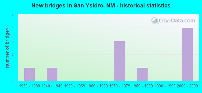
- New bridges - historical statistics
- 11930-1939
- 11940-1949
- 31970-1979
- 11980-1989
- 42000-2009


- Bridge Condition - Superstructure
- 85.7%Good
- 14.3%Satisfactory

- Bridge Condition - Substructure
- 85.7%Good
- 14.3%Satisfactory

- Bridge Condition - Channel
- 20.0%Very good
- 50.0%Good
- 20.0%Satisfactory
- 10.0%Fair

- Bridge Condition - Culverts
- 33.3%Good
- 66.7%Satisfactory
Find on map >> Show street view
Structure Number: 3222, Location: 15.3 MI E NM-48/CAPITAN (Lat: 33.466017, Lng: -105.348806), Route carried "on" structure: US 380, Year Built: 1941, Status: Open, Structure Length: 0.94m (3.08ft), Average Daily Traffic: 822 (year 2020), Truck Traffic: 20%, Average Future Daily Traffic: 1,194 (year 2040), Design Load: H 15, Features Intersected: UNNAMED WATERWAY
Minimum Vertical Clearance: 30+ m (98+ ft), Kilometerpoint: 161.739, Lanes on structure: 2, Base Highway Network: Yes, Owner: State Highway Agency, Approaching Roadway Width: 8.2m (26.9ft), Skew: 3 degrees, Material/Design: Concrete continuous, Design/Construction: Culvert, Number Of Spans In Main Unit: 4, Length of Maximum Span: 1.8m (5.9ft)
Condition: Channel: Satisfactory, Culverts: Satisfactory, Operating Rating: 40.5 metric tons, Method Used To Determine Operating Rating: Load Factor (LF), Inventory Rating: 24.3 metric tons, Method Used To Determine Inventory Rating: Load Factor (LF), Structural Evaluation: Equal to present minimum criteria, Waterway Adequacy: Equal to present minimum criteria, Approach Roadway Alignment: Equal to present minimum criteria, Length Of Structure Improvement: 0.94m (3.08ft), Designated Inspection Frequency: Every 48 months, Inspection Date: May 2019, Bridge Improvement Cost: $65,000, Roadway Improvement Cost: $6,000, Total Project Cost: $98,000 ( Estimate for 2020)
Find on map >> Show street view
Structure Number: 5584, Location: 2.5M N OF US70/LAS CRUCES (Lat: 32.345714, Lng: -106.815694), Route carried "on" structure: State highway 185, Year Built: 1933, Status: Open, Structure Length: 0.63m (2.07ft), Average Daily Traffic: 5,746 (year 2020), Truck Traffic: 7%, Average Future Daily Traffic: 8,086 (year 2040), Design Load: H 15, Features Intersected: LEASBURG CANAL
Minimum Vertical Clearance: 30+ m (98+ ft), Kilometerpoint: 4.023, Lanes on structure: 2, Base Highway Network: Yes, Owner: State Highway Agency, Approaching Roadway Width: 7.5m (24.6ft), Material/Design: Concrete continuous, Design/Construction: Culvert, Number Of Spans In Main Unit: 2, Length of Maximum Span: 3.0m (9.8ft)
Condition: Channel: Fair, Culverts: Satisfactory, Operating Rating: 57.2 metric tons, Method Used To Determine Operating Rating: Load Factor (LF), Inventory Rating: 24.5 metric tons, Method Used To Determine Inventory Rating: Load Factor (LF), Structural Evaluation: Equal to present minimum criteria, Waterway Adequacy: Equal to present desirable criteria, Approach Roadway Alignment: Equal to present desirable criteria, Length Of Structure Improvement: 0.70m (2.30ft), Designated Inspection Frequency: Every 24 months, Inspection Date: January 2021, Bridge Improvement Cost: $47,000, Roadway Improvement Cost: $4,000, Total Project Cost: $70,000
Find on map >> Show street view
Structure Number: 7549, Location: 22.7 MI N JCT I-25 US 550 (Lat: 35.544578, Lng: -106.782222), Route carried "on" structure: US 550, Year Built: 1979, Year Reconstructed: 1998, Status: Open, Structure Length: 13.66m (44.82ft), Average Daily Traffic: 8,108 (year 2020), Truck Traffic: 16%, Average Future Daily Traffic: 6,257 (year 2040), Design Load: HS 20, Features Intersected: RIO SALADO
Minimum Vertical Clearance: 30+ m (98+ ft), Kilometerpoint: 36.555, Lanes on structure: 4, Base Highway Network: Yes, Owner: State Highway Agency, Approaching Roadway Width: 20.7m (67.9ft), Skew: 20 degrees, Material/Design: Prestressed concrete continuous, Design/Construction: Stringer/Multi-beam, Number Of Spans In Main Unit: 8, Length of Maximum Span: 17.6m (57.7ft), Curb-To-Curb Width: 20.4m (66.9ft), Out-to-Out Width: 21.3m (69.9ft)
Condition: Deck: Good, Superstructure: Good, Substructure: Good, Channel: Good, Operating Rating: 55.7 metric tons, Method Used To Determine Operating Rating: Load Factor (LF), Inventory Rating: 34.5 metric tons, Method Used To Determine Inventory Rating: Load Factor (LF), Structural Evaluation: Better than present minimum criteria, Deck Geometry: Superior to present desirable criteria, Waterway Adequacy: Equal to present desirable criteria, Approach Roadway Alignment: Equal to present desirable criteria, Length Of Structure Improvement: 13.66m (44.82ft), Designated Inspection Frequency: Every 24 months, Inspection Date: September 2020, Bridge Improvement Cost: $1,534,000, Roadway Improvement Cost: $153,000, Total Project Cost: $2,301,000 ( Estimate for 2020), Deck Structure Type: Concrete Cast-file-Place
Find on map >> Show street view
Structure Number: 755, Location: 24.4 MI NW OF JCT I-25 (Lat: 35.555778, Lng: -106.797289), Route carried "on" structure: US 550, Year Built: 1979, Year Reconstructed: 2001, Status: Open, Structure Length: 4.22m (13.85ft), Average Daily Traffic: 4,695 (year 2020), Truck Traffic: 28%, Average Future Daily Traffic: 4,185 (year 2040), Design Load: HS 20, Features Intersected: UNNAMED WATERWAY
Minimum Vertical Clearance: 30+ m (98+ ft), Kilometerpoint: 39.641, Lanes on structure: 4, Base Highway Network: Yes, Owner: State Highway Agency, Approaching Roadway Width: 20.9m (68.6ft), Skew: 21 degrees, Material/Design: Prestressed concrete continuous, Design/Construction: Stringer/Multi-beam, Number Of Spans In Main Unit: 3, Length of Maximum Span: 13.8m (45.3ft), Curb-To-Curb Width: 21.9m (71.9ft), Out-to-Out Width: 22.9m (75.1ft)
Condition: Deck: Good, Superstructure: Good, Substructure: Good, Channel: Good, Operating Rating: 51.1 metric tons, Method Used To Determine Operating Rating: Load Factor (LF), Inventory Rating: 29.6 metric tons, Method Used To Determine Inventory Rating: Load Factor (LF), Structural Evaluation: Better than present minimum criteria, Deck Geometry: Superior to present desirable criteria, Waterway Adequacy: Equal to present desirable criteria, Approach Roadway Alignment: Equal to present desirable criteria, Length Of Structure Improvement: 4.24m (13.91ft), Designated Inspection Frequency: Every 24 months, Inspection Date: March 2021, Bridge Improvement Cost: $347,000, Roadway Improvement Cost: $34,000, Total Project Cost: $521,000 ( Estimate for 2020), Deck Structure Type: Concrete Cast-file-Place, Wearing Surface/Protective System: Deck Protection: Epoxy Coated Reinforcing
Find on map >> Show street view
Structure Number: 7952, Location: 25.0 MI NW OF JCT I-25 (Lat: 35.553364, Lng: -106.815411), Route carried "on" structure: US 550, Year Built: 1977, Year Reconstructed: 2001, Status: Open, Structure Length: 0.70m (2.30ft), Average Daily Traffic: 4,695 (year 2020), Truck Traffic: 28%, Average Future Daily Traffic: 4,185 (year 2040), Design Load: HS 20, Features Intersected: UNNAMED WATERWAY
Minimum Vertical Clearance: 30+ m (98+ ft), Kilometerpoint: 40.999, Lanes on structure: 4, Base Highway Network: Yes, Owner: State Highway Agency, Approaching Roadway Width: 20.9m (68.6ft), Skew: 24 degrees, Material/Design: Concrete continuous, Design/Construction: Culvert, Number Of Spans In Main Unit: 2, Length of Maximum Span: 2.4m (7.9ft)
Condition: Channel: Good, Culverts: Good, Operating Rating: 38.9 metric tons, Method Used To Determine Operating Rating: Load Factor (LF), Inventory Rating: 32.4 metric tons, Method Used To Determine Inventory Rating: Load Factor (LF), Structural Evaluation: Better than present minimum criteria, Waterway Adequacy: Equal to present desirable criteria, Approach Roadway Alignment: Equal to present desirable criteria, Length Of Structure Improvement: 0.70m (2.30ft), Designated Inspection Frequency: Every 48 months, Inspection Date: August 2021, Bridge Improvement Cost: $136,000, Roadway Improvement Cost: $13,000, Total Project Cost: $204,000 ( Estimate for 2020)
Find on map >> Show street view
Structure Number: 8364, Location: 1.8 MI N OF JCT US 550 (Lat: 35.573169, Lng: -106.758464), Route carried "on" structure: State highway 4, Year Built: 1981, Status: Open, Structure Length: 8.61m (28.25ft), Average Daily Traffic: 3,944 (year 2020), Truck Traffic: 20%, Average Future Daily Traffic: 5,725 (year 2040), Design Load: HS 20, Features Intersected: JEMEZ RIVER
Minimum Vertical Clearance: 30+ m (98+ ft), Kilometerpoint: 2.917, Lanes on structure: 2, Base Highway Network: Yes, Owner: State Highway Agency, Approaching Roadway Width: 13.4m (44.0ft), Skew: 3 degrees, Material/Design: Prestressed concrete continuous, Design/Construction: Stringer/Multi-beam, Number Of Spans In Main Unit: 3, Length of Maximum Span: 28.2m (92.5ft), Curb-To-Curb Width: 13.4m (44.0ft), Out-to-Out Width: 13.7m (44.9ft)
Condition: Deck: Good, Superstructure: Satisfactory, Substructure: Satisfactory, Channel: Satisfactory, Operating Rating: 53.5 metric tons, Method Used To Determine Operating Rating: Load Factor (LF), Inventory Rating: 32.4 metric tons, Method Used To Determine Inventory Rating: Load Factor (LF), Structural Evaluation: Equal to present minimum criteria, Deck Geometry: Better than present minimum criteria, Waterway Adequacy: Equal to present minimum criteria, Approach Roadway Alignment: Equal to present desirable criteria, Designated Inspection Frequency: Every 24 months, Inspection Date: October 2021, Deck Structure Type: Concrete Cast-file-Place, Wearing Surface/Protective System: Deck Protection: Epoxy Coated Reinforcing
Find on map >> Show street view
Structure Number: 9135, Location: 6.0 Mi NW of Jct. NM 4 (Lat: 35.568472, Lng: -106.860967), Route carried "on" structure: US 550, Year Built: 2001, Status: Open, Structure Length: 5.57m (18.27ft), Average Daily Traffic: 4,695 (year 2020), Truck Traffic: 28%, Average Future Daily Traffic: 4,185 (year 2040), Design Load: HS 20+Mod, Features Intersected: Rio Penasco
Minimum Vertical Clearance: 30+ m (98+ ft), Kilometerpoint: 47.801, Lanes on structure: 4, Base Highway Network: Yes, Owner: State Highway Agency, Approaching Roadway Width: 21.1m (69.2ft), Skew: 24 degrees, Material/Design: Prestressed concrete continuous, Design/Construction: Stringer/Multi-beam, Number Of Spans In Main Unit: 2, Length of Maximum Span: 27.1m (88.9ft), Curb-To-Curb Width: 21.5m (70.5ft), Out-to-Out Width: 22.2m (72.8ft)
Condition: Deck: Good, Superstructure: Good, Substructure: Good, Channel: Good, Operating Rating: 68.3 metric tons, Method Used To Determine Operating Rating: Load Factor (LF), Inventory Rating: 33.1 metric tons, Method Used To Determine Inventory Rating: Load Factor (LF), Structural Evaluation: Better than present minimum criteria, Deck Geometry: Superior to present desirable criteria, Waterway Adequacy: Equal to present desirable criteria, Approach Roadway Alignment: Equal to present desirable criteria, Designated Inspection Frequency: Every 24 months, Inspection Date: March 2020, Deck Structure Type: Concrete Cast-file-Place, Wearing Surface/Protective System: Wearing Surface: Epoxy Overlay, Deck Protection: Epoxy Coated Reinforcing
Find on map >> Show street view
Structure Number: 9136, Location: 8.0 Mi NW of Jct NM 4 (Lat: 35.590200, Lng: -106.887142), Route carried "on" structure: US 550, Year Built: 2001, Status: Open, Structure Length: 4.18m (13.71ft), Average Daily Traffic: 4,695 (year 2020), Truck Traffic: 28%, Average Future Daily Traffic: 4,185 (year 2040), Design Load: HS 20, Features Intersected: Cuchilla Arroyo
Minimum Vertical Clearance: 30+ m (98+ ft), Kilometerpoint: 51.019, Lanes on structure: 4, Base Highway Network: Yes, Owner: State Highway Agency, Approaching Roadway Width: 20.7m (67.9ft), Skew: 20 degrees, Material/Design: Prestressed concrete continuous, Design/Construction: Stringer/Multi-beam, Number Of Spans In Main Unit: 2, Length of Maximum Span: 20.4m (66.9ft), Curb-To-Curb Width: 21.5m (70.5ft), Out-to-Out Width: 22.3m (73.2ft)
Condition: Deck: Good, Superstructure: Good, Substructure: Good, Channel: Good, Operating Rating: 58.1 metric tons, Method Used To Determine Operating Rating: Load Factor (LF), Inventory Rating: 34.8 metric tons, Method Used To Determine Inventory Rating: Load Factor (LF), Structural Evaluation: Better than present minimum criteria, Deck Geometry: Superior to present desirable criteria, Waterway Adequacy: Equal to present desirable criteria, Approach Roadway Alignment: Equal to present desirable criteria, Designated Inspection Frequency: Every 24 months, Inspection Date: March 2020, Deck Structure Type: Concrete Cast-file-Place, Wearing Surface/Protective System: Deck Protection: Epoxy Coated Reinforcing
Find on map >> Show street view
Structure Number: 9326, Location: 11.1 Mi. E. Jct. US 550/N (Lat: 35.996350, Lng: -106.825539), Route carried "on" structure: State highway 126, Year Built: 2003, Status: Open, Structure Length: 1.71m (5.61ft), Average Daily Traffic: 47 (year 2020), Truck Traffic: 19%, Average Future Daily Traffic: 40 (year 2040), Design Load: HS 20, Features Intersected: CLEAR CREEK
Minimum Vertical Clearance: 30+ m (98+ ft), Kilometerpoint: 17.864, Lanes on structure: 2, Owner: State Highway Agency, Approaching Roadway Width: 7.3m (24.0ft), Material/Design: Prestressed concrete, Design/Construction: Stringer/Multi-beam, Number Of Spans In Main Unit: 1, Length of Maximum Span: 16.8m (55.1ft), Curb-To-Curb Width: 9.0m (29.5ft), Out-to-Out Width: 9.9m (32.5ft)
Condition: Deck: Good, Superstructure: Good, Substructure: Good, Channel: Very good, Operating Rating: 67.3 metric tons, Method Used To Determine Operating Rating: Load Factor (LF), Inventory Rating: 40.2 metric tons, Method Used To Determine Inventory Rating: Load Factor (LF), Structural Evaluation: Better than present minimum criteria, Deck Geometry: Better than present minimum criteria, Waterway Adequacy: Equal to present desirable criteria, Approach Roadway Alignment: Equal to present desirable criteria, Designated Inspection Frequency: Every 24 months, Inspection Date: April 2020, Deck Structure Type: Concrete Cast-file-Place, Wearing Surface/Protective System: Deck Protection: Epoxy Coated Reinforcing
Find on map >> Show street view
Structure Number: 9439, Location: 28.9 MI E OF US-550 (Lat: 35.885817, Lng: -106.722311), Route carried "on" structure: State highway 126, Year Built: 2007, Status: Open, Structure Length: 16.31m (53.51ft), Average Daily Traffic: 123 (year 2020), Truck Traffic: 20%, Average Future Daily Traffic: 106 (year 2040), Design Load: HS 20, Features Intersected: RIO CEBOLLA
Minimum Vertical Clearance: 30+ m (98+ ft), Kilometerpoint: 46.510, Lanes on structure: 2, Owner: State Highway Agency, Approaching Roadway Width: 10.7m (35.1ft), Material/Design: Prestressed concrete continuous, Design/Construction: Stringer/Multi-beam, Number Of Spans In Main Unit: 6, Length of Maximum Span: 29.0m (95.1ft), Curb-To-Curb Width: 9.8m (32.2ft), Out-to-Out Width: 10.6m (34.8ft)
Condition: Deck: Good, Superstructure: Good, Substructure: Good, Channel: Very good, Operating Rating: 53.5 metric tons, Method Used To Determine Operating Rating: Load Factor (LF), Inventory Rating: 32.4 metric tons, Method Used To Determine Inventory Rating: Load Factor (LF), Structural Evaluation: Better than present minimum criteria, Deck Geometry: Better than present minimum criteria, Waterway Adequacy: Superior to present desirable criteria, Approach Roadway Alignment: Equal to present minimum criteria, Designated Inspection Frequency: Every 24 months, Inspection Date: April 2020, Deck Structure Type: Concrete Cast-file-Place, Wearing Surface/Protective System: Wearing Surface: Epoxy Overlay, Deck Protection: Epoxy Coated Reinforcing