Bridge Statistics for Sanborn, Minnesota (MN)
Condition, Traffic, Stress, Structural Evaluation, Project Costs
- National Bridge Inventory (NBI) Statistics
- 19Number of bridges
- 151ft / 45.6mTotal length
- $1,290,000,000Total costs
- 13,744Total average daily traffic
- 2,909Total average daily truck traffic
- National Bridge Inventory (NBI) Registered Bridges for Sanborn
- No street view available for this location
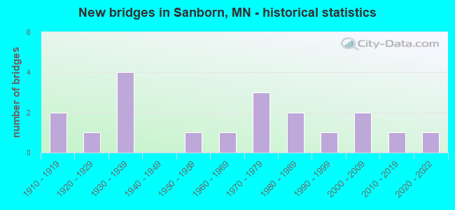
- New bridges - historical statistics
- 21910-1919
- 11920-1929
- 41930-1939
- 11950-1959
- 11960-1969
- 31970-1979
- 21980-1989
- 11990-1999
- 22000-2009
- 12010-2019
- 12020-2022

- Bridge Condition - Deck
- 30.0%Very good
- 20.0%Good
- 30.0%Satisfactory
- 10.0%Fair
- 10.0%Poor

- Bridge Condition - Superstructure
- 10.0%Excellent
- 30.0%Very good
- 10.0%Good
- 30.0%Satisfactory
- 10.0%Fair
- 10.0%Poor

- Bridge Condition - Substructure
- 10.0%Excellent
- 10.0%Very good
- 20.0%Good
- 30.0%Satisfactory
- 10.0%Fair
- 20.0%Poor

- Bridge Condition - Channel
- 11.8%Very good
- 35.3%Good
- 29.4%Satisfactory
- 17.6%Fair
- 5.9%Poor

- Bridge Condition - Culverts
- 12.5%Very good
- 25.0%Good
- 50.0%Satisfactory
- 12.5%Poor
Find on map >> Show street view
Structure Number: 8542, Location: 0.5 mi W of jct CSAH 23 (Lat: 44.194150, Lng: -95.059792), Route carried "on" structure: County highway 2, Year Built: 2002, Status: Open, Structure Length: 3.71m (12.17ft), Average Daily Traffic: 202 (year 2008), Average Future Daily Traffic: 205 (year 2029), Design Load: HS 25 or greater, Features Intersected: Mound Creek
Minimum Vertical Clearance: 30+ m (98+ ft), Kilometerpoint: 0.000, Lanes on structure: 2, Owner: County Highway Agency, Approaching Roadway Width: 11.0m (36.1ft), Material/Design: Prestressed concrete, Design/Construction: Stringer/Multi-beam, Number Of Spans In Main Unit: 1, Length of Maximum Span: 36.6m (120.1ft), Curb-To-Curb Width: 12.2m (40.0ft), Out-to-Out Width: 13.2m (43.3ft)
Condition: Deck: Very good, Superstructure: Very good, Substructure: Good, Channel: Very good, Operating Rating: 60.0 metric tons, Method Used To Determine Operating Rating: Load Factor (LF), Inventory Rating: 33.1 metric tons, Method Used To Determine Inventory Rating: Load Factor (LF), Structural Evaluation: Better than present minimum criteria, Deck Geometry: Superior to present desirable criteria, Waterway Adequacy: Equal to present desirable criteria, Approach Roadway Alignment: Equal to present desirable criteria, Designated Inspection Frequency: Every 24 months, Inspection Date: October 2020, Deck Structure Type: Concrete Cast-file-Place, Wearing Surface/Protective System: Wearing Surface: Monolithic Concrete, Deck Protection: Epoxy Coated Reinforcing
Find on map >> Show street view
Structure Number: 1238, Location: 0.6 MI S OF JCT CSAH 15 (Lat: 44.201019, Lng: -95.128219), Route carried "on" structure: City street 22, Year Built: 1918, Status: Posted for load, Structure Length: 4.34m (14.24ft), Average Daily Traffic: 70 (year 1971), Average Future Daily Traffic: 70 (year 2029), Features Intersected: COTTONWOOD RIVER
Minimum Vertical Clearance: 30+ m (98+ ft), Kilometerpoint: 0.000, Lanes on structure: 1, Owner: City or Municipal Highway Agency, Approaching Roadway Width: 6.7m (22.0ft), Material/Design: Concrete, Design/Construction: Girder and Floorbeam System, Number Of Spans In Main Unit: 4, Length of Maximum Span: 11.6m (38.1ft), Curb-To-Curb Width: 5.3m (17.4ft), Out-to-Out Width: 5.5m (18.0ft)
Condition: Deck: Fair, Superstructure: Fair, Substructure: Poor, Channel: Fair, Operating Rating: 20.4 metric tons, Method Used To Determine Operating Rating: Field evaluation and documented engineering judgment, Inventory Rating: 12.1 metric tons, Method Used To Determine Inventory Rating: Field evaluation and documented engineering judgment, Structural Evaluation: Meets minimum limits, Deck Geometry: High priority of corrective action, Waterway Adequacy: Equal to present minimum criteria, Approach Roadway Alignment: Somewhat better than minimum adequacy, Bridge Posting: Required (Relationship of Operating Rating to Maximum Legal Load: > 39.9% below), Length Of Structure Improvement: 1.59m (5.22ft), Designated Inspection Frequency: Every 12 months, Underwater Inspection Frequency: Every 60 months, Inspection Date: November 2021, Underwater Inspection Date: October 2020, Bridge Improvement Cost: $622,000,000, Roadway Improvement Cost: $29,000,000, Total Project Cost: $448,000,000, Deck Structure Type: Concrete Cast-file-Place, Wearing Surface/Protective System: Wearing Surface: Gravel
Find on map >> Show street view
Structure Number: 1238A, Location: 0.5 MI S OF JCT CSAH 15 (Lat: 44.202839, Lng: -95.126822), Route carried "on" structure: City street 22, Year Built: 1918, Status: Posted for load, Structure Length: 2.09m (6.86ft), Average Daily Traffic: 70 (year 1971), Average Future Daily Traffic: 70 (year 2029), Features Intersected: STREAM
Minimum Vertical Clearance: 30+ m (98+ ft), Kilometerpoint: 0.000, Lanes on structure: 1, Owner: City or Municipal Highway Agency, Approaching Roadway Width: 6.7m (22.0ft), Material/Design: Concrete, Design/Construction: Slab, Number Of Spans In Main Unit: 3, Length of Maximum Span: 6.8m (22.3ft), Curb-To-Curb Width: 5.2m (17.1ft), Out-to-Out Width: 5.5m (18.0ft)
Condition: Deck: Poor, Superstructure: Poor, Substructure: Poor, Channel: Poor, Operating Rating: 9.4 metric tons, Method Used To Determine Operating Rating: Load Factor (LF), Inventory Rating: 5.5 metric tons, Method Used To Determine Inventory Rating: Load Factor (LF), Structural Evaluation: High priority of corrective action, Deck Geometry: High priority of corrective action, Waterway Adequacy: Equal to present minimum criteria, Approach Roadway Alignment: Meets minimum limits, Bridge Posting: Required (Relationship of Operating Rating to Maximum Legal Load: > 39.9% below), Length Of Structure Improvement: 0.76m (2.49ft), Designated Inspection Frequency: Every 12 months, Inspection Date: November 2021, Bridge Improvement Cost: $265,000,000, Roadway Improvement Cost: $13,000,000, Total Project Cost: $198,000,000, Deck Structure Type: Concrete Cast-file-Place, Wearing Surface/Protective System: Wearing Surface: Gravel
Find on map >> Show street view
Structure Number: 5501, Location: IN SANBORN (Lat: 44.210297, Lng: -95.121169), Route carried "on" structure: , Year Built: 1936, Status: Open, Structure Length: 1.09m (3.58ft), Features Intersected: US 71, Facility Carried by Structure: RAILROAD
Lanes under structure: 2, Owner: Railroad, Material/Design: Steel, Design/Construction: Stringer/Multi-beam, Number Of Spans In Main Unit: 1, Length of Maximum Span: 10.7m (35.1ft), Out-to-Out Width: 8.5m (27.9ft)
Condition: Deck: Satisfactory, Superstructure: Satisfactory, Substructure: Fair, Underclear: High priority of corrective action, Bridge Posting: Required (Relationship of Operating Rating to Maximum Legal Load: > 39.9% below), Length Of Structure Improvement: 0.52m (1.71ft), Designated Inspection Frequency: Every 12 months, Inspection Date: April 2021, Bridge Improvement Cost: $999,999,000, Roadway Improvement Cost: $450,000,000
Find on map >> Show street view
Structure Number: 563, Location: 3.6 MI S OF SANBORN (Lat: 44.147008, Lng: -95.120964), Route carried "on" structure: US 71, Year Built: 1936, Status: Open, Structure Length: 0.67m (2.20ft), Average Daily Traffic: 2,337 (year 2019), Truck Traffic: 23%, Average Future Daily Traffic: 2,350 (year 2039), Design Load: H 15, Features Intersected: STREAM
Minimum Vertical Clearance: 30+ m (98+ ft), Kilometerpoint: 0.000, Lanes on structure: 2, Base Highway Network: Yes, Owner: State Highway Agency, Approaching Roadway Width: 12.2m (40.0ft), Material/Design: Concrete, Design/Construction: Culvert, Number Of Spans In Main Unit: 2, Length of Maximum Span: 3.0m (9.8ft)
Condition: Channel: Fair, Culverts: Satisfactory, Operating Rating: 39.2 metric tons, Method Used To Determine Operating Rating: Assigned ratings based on Allowable Stress Design (ASD) reported in metric tons, Inventory Rating: 29.4 metric tons, Method Used To Determine Inventory Rating: Assigned ratings based on Allowable Stress Design (ASD) reported in metric tons, Structural Evaluation: Equal to present minimum criteria, Waterway Adequacy: Equal to present desirable criteria, Approach Roadway Alignment: Equal to present desirable criteria, Length Of Structure Improvement: 0.34m (1.12ft), Designated Inspection Frequency: Every 24 months, Inspection Date: June 2020, Bridge Improvement Cost: $77,000,000, Roadway Improvement Cost: $7,000,000, Total Project Cost: $114,000,000
Find on map >> Show street view
Structure Number: 6226, Location: 3.3 MI N OF SANBORN (Lat: 44.258247, Lng: -95.128067), Route carried "on" structure: US 71, Year Built: 1936, Status: Open, Structure Length: 0.67m (2.20ft), Average Daily Traffic: 2,500 (year 2019), Truck Traffic: 27%, Average Future Daily Traffic: 2,450 (year 2039), Design Load: H 15, Features Intersected: COAL MINE CREEK
Minimum Vertical Clearance: 30+ m (98+ ft), Kilometerpoint: 0.000, Lanes on structure: 2, Base Highway Network: Yes, Owner: State Highway Agency, Approaching Roadway Width: 13.4m (44.0ft), Material/Design: Concrete, Design/Construction: Culvert, Number Of Spans In Main Unit: 2, Length of Maximum Span: 3.1m (10.2ft)
Condition: Channel: Good, Culverts: Satisfactory, Operating Rating: 39.2 metric tons, Method Used To Determine Operating Rating: Assigned ratings based on Allowable Stress Design (ASD) reported in metric tons, Inventory Rating: 29.4 metric tons, Method Used To Determine Inventory Rating: Assigned ratings based on Allowable Stress Design (ASD) reported in metric tons, Structural Evaluation: Equal to present minimum criteria, Waterway Adequacy: Equal to present desirable criteria, Approach Roadway Alignment: Equal to present desirable criteria, Length Of Structure Improvement: 0.34m (1.12ft), Designated Inspection Frequency: Every 24 months, Inspection Date: August 2021, Bridge Improvement Cost: $77,000,000, Roadway Improvement Cost: $8,000,000, Total Project Cost: $130,000,000
Find on map >> Show street view
Structure Number: 64011, Location: 2.8 MI S OF JCT US 14 (Lat: 44.198747, Lng: -95.121231), Route carried "on" structure: US 71, Year Built: 2021, Status: Open, Structure Length: 8.10m (26.57ft), Average Daily Traffic: 2,750 (year 2019), Truck Traffic: 21%, Average Future Daily Traffic: 3,240 (year 2039), Design Load: HL 93, Features Intersected: COTTONWOOD RIVER
Minimum Vertical Clearance: 30+ m (98+ ft), Kilometerpoint: 0.000, Lanes on structure: 2, Base Highway Network: Yes, Owner: State Highway Agency, Approaching Roadway Width: 9.8m (32.2ft), Skew: 3 degrees, Material/Design: Prestressed concrete, Design/Construction: Stringer/Multi-beam, Number Of Spans In Main Unit: 3, Length of Maximum Span: 27.1m (88.9ft), Curb-To-Curb Width: 13.4m (44.0ft), Out-to-Out Width: 14.3m (46.9ft)
Condition: Deck: Very good, Superstructure: Excellent, Substructure: Excellent, Channel: Good, Operating Rating: 54.1 metric tons, Method Used To Determine Operating Rating: Load and Resistance Factor Rating (LRFR) rating reported by rating factor(RF) method using HL-93 loadings, Inventory Rating: 41.8 metric tons, Method Used To Determine Inventory Rating: Load and Resistance Factor Rating (LRFR) rating reported by rating factor(RF) method using HL-93 loadings, Structural Evaluation: Superior to present desirable criteria, Deck Geometry: Better than present minimum criteria, Waterway Adequacy: Superior to present desirable criteria, Approach Roadway Alignment: Equal to present desirable criteria, Designated Inspection Frequency: Every 24 months, Inspection Date: October 2021, Deck Structure Type: Concrete Cast-file-Place, Wearing Surface/Protective System: Wearing Surface: Monolithic Concrete, Deck Protection: Epoxy Coated Reinforcing
Find on map >> Show street view
Structure Number: 64534, Location: 1.1 MI N OF JCT TH 14 (Lat: 44.253150, Lng: -95.107856), Route carried "on" structure: County highway 2, Year Built: 1977, Status: Open, Structure Length: 2.19m (7.19ft), Average Daily Traffic: 40 (year 1977), Average Future Daily Traffic: 40 (year 2029), Design Load: HS 20, Features Intersected: COAL MINE CREEK
Minimum Vertical Clearance: 30+ m (98+ ft), Kilometerpoint: 0.000, Lanes on structure: 2, Owner: Town or Township Highway Agency, Approaching Roadway Width: 8.5m (27.9ft), Material/Design: Wood or Timber, Design/Construction: Slab, Number Of Spans In Main Unit: 3, Length of Maximum Span: 7.3m (24.0ft), Curb-To-Curb Width: 8.5m (27.9ft), Out-to-Out Width: 9.1m (29.9ft)
Condition: Deck: Satisfactory, Superstructure: Satisfactory, Substructure: Satisfactory, Channel: Fair, Operating Rating: 56.5 metric tons, Method Used To Determine Operating Rating: Allowable Stress (AS), Inventory Rating: 39.5 metric tons, Method Used To Determine Inventory Rating: Allowable Stress (AS), Structural Evaluation: Equal to present minimum criteria, Deck Geometry: Better than present minimum criteria, Waterway Adequacy: Better than present minimum criteria, Approach Roadway Alignment: Equal to present minimum criteria, Designated Inspection Frequency: Every 24 months, Inspection Date: October 2021, Deck Structure Type: Wood or Timber, Wearing Surface/Protective System: Wearing Surface: Bituminous
Find on map >> Show street view
Structure Number: 6455, Location: 2.4 MI W OF JCT TH 71 (Lat: 44.224972, Lng: -95.176706), Route carried "on" structure: County highway 147, Year Built: 1993, Status: Open, Structure Length: 4.18m (13.71ft), Average Daily Traffic: 7 (year 1971), Average Future Daily Traffic: 7 (year 2029), Design Load: HS 25 or greater, Features Intersected: COTTONWOOD RIVER
Minimum Vertical Clearance: 30+ m (98+ ft), Kilometerpoint: 0.000, Lanes on structure: 2, Owner: Town or Township Highway Agency, Approaching Roadway Width: 7.3m (24.0ft), Skew: 2 degrees, Material/Design: Concrete continuous, Design/Construction: Slab, Number Of Spans In Main Unit: 3, Length of Maximum Span: 16.5m (54.1ft), Curb-To-Curb Width: 8.5m (27.9ft), Out-to-Out Width: 9.5m (31.2ft)
Condition: Deck: Good, Superstructure: Good, Substructure: Satisfactory, Channel: Satisfactory, Operating Rating: 72.7 metric tons, Method Used To Determine Operating Rating: Load Factor (LF), Inventory Rating: 43.5 metric tons, Method Used To Determine Inventory Rating: Load Factor (LF), Structural Evaluation: Equal to present minimum criteria, Deck Geometry: Better than present minimum criteria, Waterway Adequacy: Equal to present minimum criteria, Approach Roadway Alignment: Better than present minimum criteria, Designated Inspection Frequency: Every 24 months, Inspection Date: October 2021, Deck Structure Type: Concrete Cast-file-Place, Wearing Surface/Protective System: Wearing Surface: Monolithic Concrete, Deck Protection: Epoxy Coated Reinforcing
Find on map >> Show street view
Structure Number: 64575, Location: 0.8 MI W JCT US 71 (Lat: 44.195319, Lng: -95.138108), Route carried "on" structure: County highway 41, Year Built: 2006, Status: Open, Structure Length: 2.89m (9.48ft), Average Daily Traffic: 80 (year 2011), Average Future Daily Traffic: 80 (year 2039), Design Load: HS 25 or greater, Features Intersected: DRY CREEK
Minimum Vertical Clearance: 30+ m (98+ ft), Kilometerpoint: 0.000, Lanes on structure: 2, Owner: County Highway Agency, Approaching Roadway Width: 8.5m (27.9ft), Material/Design: Prestressed concrete, Design/Construction: Stringer/Multi-beam, Number Of Spans In Main Unit: 1, Length of Maximum Span: 27.4m (89.9ft), Curb-To-Curb Width: 11.0m (36.1ft), Out-to-Out Width: 12.0m (39.4ft)
Condition: Deck: Very good, Superstructure: Very good, Substructure: Very good, Channel: Good, Operating Rating: 74.4 metric tons, Method Used To Determine Operating Rating: Load Factor (LF), Inventory Rating: 43.3 metric tons, Method Used To Determine Inventory Rating: Load Factor (LF), Structural Evaluation: Equal to present desirable criteria, Deck Geometry: Superior to present desirable criteria, Waterway Adequacy: Equal to present desirable criteria, Approach Roadway Alignment: Equal to present desirable criteria, Designated Inspection Frequency: Every 24 months, Inspection Date: October 2021, Deck Structure Type: Concrete Cast-file-Place, Wearing Surface/Protective System: Wearing Surface: Monolithic Concrete, Deck Protection: Epoxy Coated Reinforcing
Find on map >> Show street view
Structure Number: 6458, Location: 1.0 MI W OF JCT TH 71 (Lat: 44.209767, Lng: -95.141792), Route carried "on" structure: County highway 15, Year Built: 2014, Status: Open, Structure Length: 7.16m (23.49ft), Average Daily Traffic: 476 (year 2012), Average Future Daily Traffic: 572 (year 2033), Design Load: HL 93, Features Intersected: COTTONWOOD RIVER
Minimum Vertical Clearance: 30+ m (98+ ft), Kilometerpoint: 0.000, Lanes on structure: 2, Owner: County Highway Agency, Approaching Roadway Width: 9.8m (32.2ft), Skew: 3 degrees, Material/Design: Prestressed concrete, Design/Construction: Stringer/Multi-beam, Number Of Spans In Main Unit: 3, Length of Maximum Span: 23.7m (77.8ft), Curb-To-Curb Width: 9.8m (32.2ft), Out-to-Out Width: 10.8m (35.4ft)
Condition: Deck: Good, Superstructure: Very good, Substructure: Good, Channel: Good, Operating Rating: 59.9 metric tons, Method Used To Determine Operating Rating: Load and Resistance Factor Rating (LRFR) rating reported by rating factor(RF) method using HL-93 loadings, Inventory Rating: 36.3 metric tons, Method Used To Determine Inventory Rating: Load and Resistance Factor Rating (LRFR) rating reported by rating factor(RF) method using HL-93 loadings, Structural Evaluation: Better than present minimum criteria, Deck Geometry: Equal to present minimum criteria, Waterway Adequacy: Better than present minimum criteria, Approach Roadway Alignment: Better than present minimum criteria, Designated Inspection Frequency: Every 24 months, Inspection Date: October 2021, Deck Structure Type: Concrete Cast-file-Place, Wearing Surface/Protective System: Wearing Surface: Monolithic Concrete, Deck Protection: Epoxy Coated Reinforcing
Find on map >> Show street view
Structure Number: 91004, Location: 4.1 MI S OF SANBORN (Lat: 44.136214, Lng: -95.120789), Route carried "on" structure: US 71, Year Built: 1960, Status: Open, Structure Length: 0.69m (2.26ft), Average Daily Traffic: 2,337 (year 2019), Truck Traffic: 23%, Average Future Daily Traffic: 2,350 (year 2039), Design Load: H 20, Features Intersected: STREAM
Minimum Vertical Clearance: 30+ m (98+ ft), Kilometerpoint: 0.000, Lanes on structure: 2, Base Highway Network: Yes, Owner: State Highway Agency, Approaching Roadway Width: 12.2m (40.0ft), Material/Design: Concrete, Design/Construction: Culvert, Number Of Spans In Main Unit: 2, Length of Maximum Span: 3.0m (9.8ft)
Condition: Channel: Satisfactory, Culverts: Satisfactory, Operating Rating: 39.2 metric tons, Method Used To Determine Operating Rating: Assigned ratings based on Allowable Stress Design (ASD) reported in metric tons, Inventory Rating: 29.4 metric tons, Method Used To Determine Inventory Rating: Assigned ratings based on Allowable Stress Design (ASD) reported in metric tons, Structural Evaluation: Equal to present minimum criteria, Waterway Adequacy: Equal to present desirable criteria, Approach Roadway Alignment: Equal to present desirable criteria, Length Of Structure Improvement: 0.34m (1.12ft), Designated Inspection Frequency: Every 24 months, Inspection Date: June 2020, Bridge Improvement Cost: $79,000,000, Roadway Improvement Cost: $10,000,000, Total Project Cost: $150,000,000
Find on map >> Show street view
Structure Number: 92878, Location: 1.0 MI N OF JCT TH 14 (Lat: 44.253403, Lng: -95.088203), Route carried "on" structure: County highway 1, Year Built: 1971, Status: Open, Structure Length: 1.03m (3.38ft), Average Daily Traffic: 80 (year 2014), Average Future Daily Traffic: 80 (year 2039), Design Load: HS 20, Features Intersected: COAL MINE CREEK
Minimum Vertical Clearance: 30+ m (98+ ft), Kilometerpoint: 0.000, Lanes on structure: 2, Owner: County Highway Agency, Approaching Roadway Width: 9.8m (32.2ft), Material/Design: Concrete, Design/Construction: Culvert, Number Of Spans In Main Unit: 2, Length of Maximum Span: 3.9m (12.8ft)
Condition: Channel: Good, Culverts: Good, Operating Rating: 53.9 metric tons, Method Used To Determine Operating Rating: Assigned ratings based on Allowable Stress Design (ASD) reported in metric tons, Inventory Rating: 35.9 metric tons, Method Used To Determine Inventory Rating: Assigned ratings based on Allowable Stress Design (ASD) reported in metric tons, Structural Evaluation: Better than present minimum criteria, Waterway Adequacy: Equal to present desirable criteria, Approach Roadway Alignment: Equal to present desirable criteria, Designated Inspection Frequency: Every 48 months, Inspection Date: December 2019
Find on map >> Show street view
Structure Number: 95762, Location: 2.1 MI S OF JCT CSAH 21 (Lat: 44.136769, Lng: -95.100625), Route carried "on" structure: County highway 369, Year Built: 1982, Status: Open, Structure Length: 1.52m (4.99ft), Average Daily Traffic: 28 (year 1982), Average Future Daily Traffic: 28 (year 2029), Design Load: HS 20, Features Intersected: STREAM
Minimum Vertical Clearance: 30+ m (98+ ft), Kilometerpoint: 0.000, Lanes on structure: 2, Owner: County Highway Agency, Approaching Roadway Width: 8.5m (27.9ft), Material/Design: Concrete, Design/Construction: Culvert, Number Of Spans In Main Unit: 4, Length of Maximum Span: 3.0m (9.8ft)
Condition: Channel: Good, Culverts: Good, Operating Rating: 37.1 metric tons, Method Used To Determine Operating Rating: Load Factor (LF), Inventory Rating: 22.2 metric tons, Method Used To Determine Inventory Rating: Load Factor (LF), Structural Evaluation: Equal to present minimum criteria, Waterway Adequacy: Equal to present minimum criteria, Approach Roadway Alignment: Equal to present desirable criteria, Length Of Structure Improvement: 0.64m (2.10ft), Designated Inspection Frequency: Every 24 months, Inspection Date: October 2021, Bridge Improvement Cost: $218,000,000, Total Project Cost: $250,000,000
Find on map >> Show street view
Structure Number: L5447, Location: 0.7 MI N OF JCT TH 14 (Lat: 44.248519, Lng: -95.067917), Route carried "on" structure: County highway 171, Year Built: 1950, Status: Posted for load, Structure Length: 0.99m (3.25ft), Average Daily Traffic: 30 (year 1973), Average Future Daily Traffic: 30 (year 2029), Design Load: H 15, Features Intersected: COAL MINE CREEK
Minimum Vertical Clearance: 30+ m (98+ ft), Kilometerpoint: 0.000, Lanes on structure: 2, Owner: County Highway Agency, Approaching Roadway Width: 7.9m (25.9ft), Material/Design: Steel, Design/Construction: Stringer/Multi-beam, Number Of Spans In Main Unit: 1, Length of Maximum Span: 9.1m (29.9ft), Curb-To-Curb Width: 7.3m (24.0ft), Out-to-Out Width: 8.1m (26.6ft)
Condition: Deck: Satisfactory, Superstructure: Satisfactory, Substructure: Satisfactory, Channel: Very good, Operating Rating: 40.6 metric tons, Method Used To Determine Operating Rating: Load Factor (LF), Inventory Rating: 24.3 metric tons, Method Used To Determine Inventory Rating: Load Factor (LF), Structural Evaluation: Equal to present minimum criteria, Deck Geometry: Equal to present minimum criteria, Waterway Adequacy: Equal to present desirable criteria, Approach Roadway Alignment: Better than present minimum criteria, Bridge Posting: Required (Relationship of Operating Rating to Maximum Legal Load: 0.1 - 9.9% below), Designated Inspection Frequency: Every 24 months, Inspection Date: October 2021, Deck Structure Type: Concrete Cast-file-Place, Wearing Surface/Protective System: Wearing Surface: Monolithic Concrete
Find on map >> Show street view
Structure Number: L6591, Location: 0.8 MI N OF JCT CSAH 10 (Lat: 44.134964, Lng: -95.140847), Route carried "on" structure: County highway 147, Year Built: 1925, Status: Open, Structure Length: 0.67m (2.20ft), Average Daily Traffic: 30 (year 1986), Average Future Daily Traffic: 30 (year 2029), Features Intersected: DRY CREEK
Minimum Vertical Clearance: 30+ m (98+ ft), Kilometerpoint: 0.000, Lanes on structure: 2, Owner: Town or Township Highway Agency, Approaching Roadway Width: 8.5m (27.9ft), Material/Design: Concrete, Design/Construction: Culvert, Number Of Spans In Main Unit: 2, Length of Maximum Span: 3.2m (10.5ft)
Condition: Channel: Satisfactory, Culverts: Satisfactory, Operating Rating: 39.2 metric tons, Method Used To Determine Operating Rating: Assigned ratings based on Allowable Stress Design (ASD) reported in metric tons, Inventory Rating: 29.4 metric tons, Method Used To Determine Inventory Rating: Assigned ratings based on Allowable Stress Design (ASD) reported in metric tons, Structural Evaluation: Equal to present minimum criteria, Waterway Adequacy: Better than present minimum criteria, Approach Roadway Alignment: Equal to present desirable criteria, Designated Inspection Frequency: Every 24 months, Inspection Date: October 2021
Find on map >> Show street view
Structure Number: L9684, Location: 1.3 MI N OF JCT TH 14 (Lat: 44.257594, Lng: -95.168372), Route carried "on" structure: County highway 147, Year Built: 1977, Status: Open, Structure Length: 0.91m (2.99ft), Average Daily Traffic: 34 (year 1971), Average Future Daily Traffic: 34 (year 2029), Features Intersected: COAL MINE CREEK
Minimum Vertical Clearance: 30+ m (98+ ft), Kilometerpoint: 0.000, Lanes on structure: 2, Owner: Town or Township Highway Agency, Approaching Roadway Width: 8.5m (27.9ft), Material/Design: Steel, Design/Construction: Culvert, Number Of Spans In Main Unit: 2, Length of Maximum Span: 3.8m (12.5ft)
Condition: Channel: Satisfactory, Culverts: Poor, Operating Rating: 39.2 metric tons, Method Used To Determine Operating Rating: Assigned ratings based on Allowable Stress Design (ASD) reported in metric tons, Inventory Rating: 26.1 metric tons, Method Used To Determine Inventory Rating: Assigned ratings based on Allowable Stress Design (ASD) reported in metric tons, Structural Evaluation: Meets minimum limits, Waterway Adequacy: Better than present minimum criteria, Approach Roadway Alignment: Better than present minimum criteria, Length Of Structure Improvement: 0.46m (1.51ft), Designated Inspection Frequency: Every 24 months, Inspection Date: November 2021, Bridge Improvement Cost: $101,000,000
Find on map >> Show street view
Structure Number: R0249, Location: 0.5 MI W OF JCT CSAH 4 (Lat: 44.180242, Lng: -95.192917), Route carried "on" structure: County highway 118, Year Built: 1989, Status: Open, Structure Length: 2.70m (8.86ft), Average Daily Traffic: 23 (year 1989), Average Future Daily Traffic: 23 (year 2029), Design Load: HS 20, Features Intersected: DRY CREEK
Minimum Vertical Clearance: 30+ m (98+ ft), Kilometerpoint: 0.000, Lanes on structure: 2, Owner: Town or Township Highway Agency, Approaching Roadway Width: 8.5m (27.9ft), Skew: 4 degrees, Material/Design: Concrete, Design/Construction: Culvert, Number Of Spans In Main Unit: 3, Length of Maximum Span: 5.9m (19.4ft)
Condition: Channel: Satisfactory, Culverts: Very good, Operating Rating: 53.9 metric tons, Method Used To Determine Operating Rating: Assigned ratings based on Allowable Stress Design (ASD) reported in metric tons, Inventory Rating: 35.9 metric tons, Method Used To Determine Inventory Rating: Assigned ratings based on Allowable Stress Design (ASD) reported in metric tons, Structural Evaluation: Equal to present desirable criteria, Waterway Adequacy: Equal to present minimum criteria, Approach Roadway Alignment: Better than present minimum criteria, Designated Inspection Frequency: Every 24 months, Inspection Date: October 2021
Find on map >> Show street view
Structure Number: 5501, Location: IN SANBORN (Lat: 44.210297, Lng: -95.121169), Route carried "under" structure: US 71, Year Built: 1936, Structure Length: 0. m, Average Daily Traffic: 2,650 (year 2019), Truck Traffic: 22%, Features Intersected: US 71, Facility Carried by Structure: RAILROAD
Minimum Vertical Clearance: 4.54m (14.90ft), Kilometerpoint: 0.000, Lanes on structure: 2, Lanes under structure: 2, Material/Design: Steel, Design/Construction: Stringer/Multi-beam, Length of Maximum Span: 10.7m (35.1ft)