Bridge Statistics for Sandusky, Michigan (MI)
Condition, Traffic, Stress, Structural Evaluation, Project Costs
- National Bridge Inventory (NBI) Statistics
- 13Number of bridges
- 33ft / 10.3mTotal length
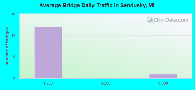
- 8,130Total average daily traffic
- 711Total average daily truck traffic
- 12,527Total future (year 2018) average daily traffic
- National Bridge Inventory (NBI) Registered Bridges for Sandusky
- No street view available for this location
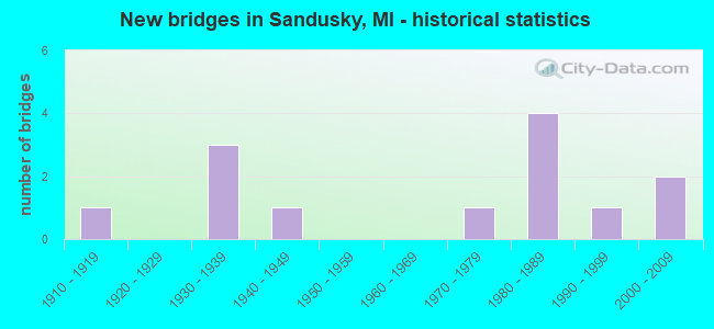
- New bridges - historical statistics
- 11910-1919
- 31930-1939
- 11940-1949
- 11970-1979
- 41980-1989
- 11990-1999
- 22000-2009
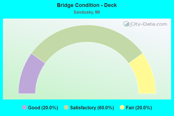
- Bridge Condition - Deck
- 20.0%Good
- 60.0%Satisfactory
- 20.0%Fair
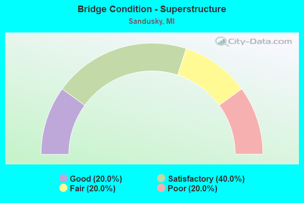
- Bridge Condition - Superstructure
- 20.0%Good
- 40.0%Satisfactory
- 20.0%Fair
- 20.0%Poor
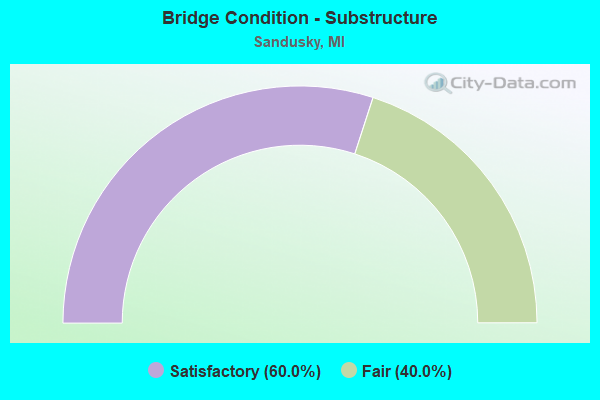
- Bridge Condition - Substructure
- 60.0%Satisfactory
- 40.0%Fair
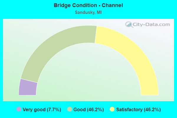
- Bridge Condition - Channel
- 7.7%Very good
- 46.2%Good
- 46.2%Satisfactory
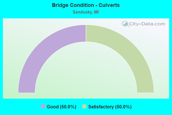
- Bridge Condition - Culverts
- 50.0%Good
- 50.0%Satisfactory
Find on map >> Show street view
Structure Number: 9468, Location: WATERTOWN TWP SEC 28 & 29 (Lat: 43.348900, Lng: -82.826000), Route carried "on" structure: State highway 19, Year Built: 2002, Status: Open, Structure Length: 0.66m (2.17ft), Average Daily Traffic: 4,553 (year 2007), Truck Traffic: 7%, Average Future Daily Traffic: 6,147 (year 2018), Design Load: HS 25 or greater, Features Intersected: HALE CREEK
Minimum Vertical Clearance: 30.48m (100.00ft), Kilometerpoint: 11.504, Lanes on structure: 2, Base Highway Network: Yes (Inventory Route: 376, Subroute: 48), Owner: State Highway Agency, Approaching Roadway Width: 11.6m (38.1ft), Material/Design: Concrete, Design/Construction: Culvert, Number Of Spans In Main Unit: 1, Length of Maximum Span: 6.1m (20.0ft), Curb-To-Curb Width: 12.2m (40.0ft), Out-to-Out Width: 13.6m (44.6ft)
Condition: Channel: Satisfactory, Culverts: Good, Operating Rating: 60.3 metric tons, Method Used To Determine Operating Rating: Load Factor (LF) rating reported by rating factor (RF) method using MS18 loading, Inventory Rating: 36.0 metric tons, Method Used To Determine Inventory Rating: Load Factor (LF) rating reported by rating factor (RF) method using MS18 loading, Structural Evaluation: Better than present minimum criteria, Deck Geometry: Equal to present minimum criteria, Waterway Adequacy: Equal to present minimum criteria, Approach Roadway Alignment: Equal to present minimum criteria, Designated Inspection Frequency: Every 24 months, Inspection Date: October 2021
Find on map >> Show street view
Structure Number: 9531, Location: SEC 22-27 WATERTOWN TWP (Lat: 43.364019, Lng: -82.792072), Route carried "on" structure: County highway 7438, Year Built: 1930, Status: Open, Structure Length: 0.73m (2.40ft), Average Daily Traffic: 610 (year 2010), Truck Traffic: 10%, Average Future Daily Traffic: 1,100 (year 2030), Design Load: H 15, Features Intersected: SMALLDON DRAIN, Facility Carried by Structure: FRENCH LINE ROAD
Minimum Vertical Clearance: 30.48m (100.00ft), Kilometerpoint: 25.353, Lanes on structure: 2, Owner: County Highway Agency, Approaching Roadway Width: 9.8m (32.2ft), Material/Design: Steel, Design/Construction: Stringer/Multi-beam, Number Of Spans In Main Unit: 1, Length of Maximum Span: 7.0m (23.0ft), Curb-To-Curb Width: 9.5m (31.2ft), Out-to-Out Width: 9.8m (32.2ft)
Condition: Deck: Satisfactory, Superstructure: Fair, Substructure: Satisfactory, Channel: Good, Operating Rating: 61.9 metric tons, Method Used To Determine Operating Rating: Load Factor (LF), Inventory Rating: 37.1 metric tons, Method Used To Determine Inventory Rating: Load Factor (LF), Structural Evaluation: Somewhat better than minimum adequacy, Deck Geometry: Equal to present minimum criteria, Waterway Adequacy: Equal to present minimum criteria, Approach Roadway Alignment: Equal to present desirable criteria, Designated Inspection Frequency: Every 24 months, Inspection Date: June 2020, Deck Structure Type: Concrete Cast-file-Place, Wearing Surface/Protective System: Wearing Surface: Bituminous
Find on map >> Show street view
Structure Number: 9533, Location: SEC 21-28 WATERTOWN TWP (Lat: 43.362972, Lng: -82.822478), Route carried "on" structure: County highway 7438, Year Built: 1930, Status: Open, Structure Length: 0.69m (2.26ft), Average Daily Traffic: 610 (year 2010), Truck Traffic: 10%, Average Future Daily Traffic: 1,100 (year 2030), Design Load: H 15, Features Intersected: BEALS & FRIZZLE DRAIN, Facility Carried by Structure: FRENCH LINE ROAD
Minimum Vertical Clearance: 30.48m (100.00ft), Kilometerpoint: 22.886, Lanes on structure: 2, Owner: County Highway Agency, Approaching Roadway Width: 9.8m (32.2ft), Material/Design: Steel, Design/Construction: Stringer/Multi-beam, Number Of Spans In Main Unit: 1, Length of Maximum Span: 6.4m (21.0ft), Curb-To-Curb Width: 9.6m (31.5ft), Out-to-Out Width: 9.8m (32.2ft)
Condition: Deck: Satisfactory, Superstructure: Satisfactory, Substructure: Satisfactory, Channel: Satisfactory, Operating Rating: 44.1 metric tons, Method Used To Determine Operating Rating: Load Factor (LF) rating reported by rating factor (RF) method using MS18 loading, Inventory Rating: 26.2 metric tons, Method Used To Determine Inventory Rating: Load Factor (LF) rating reported by rating factor (RF) method using MS18 loading, Structural Evaluation: Equal to present minimum criteria, Deck Geometry: Equal to present minimum criteria, Waterway Adequacy: Equal to present minimum criteria, Approach Roadway Alignment: Equal to present desirable criteria, Designated Inspection Frequency: Every 24 months, Inspection Date: June 2020, Deck Structure Type: Concrete Cast-file-Place, Wearing Surface/Protective System: Wearing Surface: Bituminous
Find on map >> Show street view
Structure Number: 9536, Location: SEC 14-23 MOORE TWP (Lat: 43.463578, Lng: -82.893486), Route carried "on" structure: County highway 7460, Year Built: 1930, Status: Open, Structure Length: 0.71m (2.33ft), Average Daily Traffic: 742 (year 2016), Truck Traffic: 15%, Average Future Daily Traffic: 1,275 (year 2036), Design Load: H 20, Features Intersected: MIDDLE BR DRAIN, Facility Carried by Structure: SNOVER ROAD
Minimum Vertical Clearance: 30.48m (100.00ft), Kilometerpoint: 19.752, Lanes on structure: 2, Owner: County Highway Agency, Approaching Roadway Width: 9.1m (29.9ft), Material/Design: Steel, Design/Construction: Stringer/Multi-beam, Number Of Spans In Main Unit: 1, Length of Maximum Span: 6.9m (22.6ft), Curb-To-Curb Width: 9.8m (32.2ft), Out-to-Out Width: 9.8m (32.2ft)
Condition: Deck: Fair, Superstructure: Poor, Substructure: Fair, Channel: Satisfactory, Operating Rating: 45.0 metric tons, Method Used To Determine Operating Rating: Load Factor (LF) rating reported by rating factor (RF) method using MS18 loading, Inventory Rating: 26.9 metric tons, Method Used To Determine Inventory Rating: Load Factor (LF) rating reported by rating factor (RF) method using MS18 loading, Structural Evaluation: Meets minimum limits, Deck Geometry: Equal to present minimum criteria, Waterway Adequacy: Meets minimum limits, Approach Roadway Alignment: Equal to present desirable criteria, Designated Inspection Frequency: Every 24 months, Inspection Date: April 2020, Deck Structure Type: Concrete Cast-file-Place, Wearing Surface/Protective System: Wearing Surface: Bituminous, Membrane: Preformed Fabric
Find on map >> Show street view
Structure Number: 9581, Location: SEC 27-34 CUSTER TWP (Lat: 43.436553, Lng: -82.800706), Route carried "on" structure: County highway , Year Built: 1983, Status: Open, Structure Length: 0.85m (2.79ft), Average Daily Traffic: 150 (year 2010), Truck Traffic: 10%, Average Future Daily Traffic: 270 (year 2030), Design Load: H 20, Features Intersected: DWIGHT DRAIN, Facility Carried by Structure: EDDY ROAD
Minimum Vertical Clearance: 30.48m (100.00ft), Kilometerpoint: 12.025, Lanes on structure: 2, Owner: County Highway Agency, Approaching Roadway Width: 9.1m (29.9ft), Skew: 3 degrees, Material/Design: Steel, Design/Construction: Culvert, Number Of Spans In Main Unit: 2, Length of Maximum Span: 3.9m (12.8ft), Out-to-Out Width: 6.7m (22.0ft)
Condition: Channel: Good, Culverts: Good, Operating Rating: 60.6 metric tons, Method Used To Determine Operating Rating: Load Factor (LF) rating reported by rating factor (RF) method using MS18 loading, Inventory Rating: 55.1 metric tons, Method Used To Determine Inventory Rating: Load Factor (LF) rating reported by rating factor (RF) method using MS18 loading, Structural Evaluation: Better than present minimum criteria, Waterway Adequacy: Somewhat better than minimum adequacy, Approach Roadway Alignment: Equal to present desirable criteria, Designated Inspection Frequency: Every 24 months, Inspection Date: July 2020
Find on map >> Show street view
Structure Number: 9582, Location: SEC 23-26 CUSTER TWP (Lat: 43.451692, Lng: -82.777733), Route carried "on" structure: County highway , Year Built: 1990, Status: Open, Structure Length: 0.67m (2.20ft), Average Daily Traffic: 180 (year 2010), Truck Traffic: 10%, Average Future Daily Traffic: 325 (year 2030), Design Load: H 20, Features Intersected: FYE DRAIN, Facility Carried by Structure: CUSTER ROAD
Minimum Vertical Clearance: 30.48m (100.00ft), Kilometerpoint: 8.551, Lanes on structure: 2, Owner: County Highway Agency, Approaching Roadway Width: 8.5m (27.9ft), Material/Design: Steel, Design/Construction: Culvert, Number Of Spans In Main Unit: 2, Length of Maximum Span: 3.0m (9.8ft), Out-to-Out Width: 6.1m (20.0ft)
Condition: Channel: Satisfactory, Culverts: Satisfactory, Operating Rating: 97.2 metric tons, Method Used To Determine Operating Rating: Load Factor (LF) rating reported by rating factor (RF) method using MS18 loading, Inventory Rating: 97.2 metric tons, Method Used To Determine Inventory Rating: Load Factor (LF) rating reported by rating factor (RF) method using MS18 loading, Structural Evaluation: Equal to present minimum criteria, Waterway Adequacy: Equal to present minimum criteria, Approach Roadway Alignment: Equal to present desirable criteria, Designated Inspection Frequency: Every 24 months, Inspection Date: July 2020
Find on map >> Show street view
Structure Number: 9583, Location: SEC 24-25 CUSTER TWP (Lat: 43.452122, Lng: -82.766317), Route carried "on" structure: County highway , Year Built: 1983, Status: Open, Structure Length: 0.81m (2.66ft), Average Daily Traffic: 180 (year 2010), Truck Traffic: 10%, Average Future Daily Traffic: 325 (year 2030), Design Load: H 20, Features Intersected: FYE DRAIN, Facility Carried by Structure: CUSTER ROAD
Minimum Vertical Clearance: 30.48m (100.00ft), Kilometerpoint: 9.476, Lanes on structure: 2, Owner: County Highway Agency, Approaching Roadway Width: 8.5m (27.9ft), Skew: 1 degrees, Material/Design: Steel, Design/Construction: Culvert, Number Of Spans In Main Unit: 2, Length of Maximum Span: 3.7m (12.1ft)
Condition: Channel: Very good, Culverts: Satisfactory, Operating Rating: 97.2 metric tons, Method Used To Determine Operating Rating: Load Factor (LF) rating reported by rating factor (RF) method using MS18 loading, Inventory Rating: 97.2 metric tons, Method Used To Determine Inventory Rating: Load Factor (LF) rating reported by rating factor (RF) method using MS18 loading, Structural Evaluation: Equal to present minimum criteria, Waterway Adequacy: Equal to present minimum criteria, Approach Roadway Alignment: Equal to present desirable criteria, Designated Inspection Frequency: Every 24 months, Inspection Date: July 2020
Find on map >> Show street view
Structure Number: 9586, Location: SEC 33-34 CUSTER TWP (Lat: 43.435058, Lng: -82.812017), Route carried "on" structure: County highway , Year Built: 1983, Status: Open, Structure Length: 0.92m (3.02ft), Average Daily Traffic: 180 (year 2010), Truck Traffic: 10%, Average Future Daily Traffic: 325 (year 2030), Design Load: H 20, Features Intersected: DWIGHT DRAIN, Facility Carried by Structure: BANNER ROAD
Minimum Vertical Clearance: 30.48m (100.00ft), Kilometerpoint: 11.200, Lanes on structure: 2, Owner: County Highway Agency, Approaching Roadway Width: 9.1m (29.9ft), Material/Design: Steel, Design/Construction: Culvert, Number Of Spans In Main Unit: 2, Length of Maximum Span: 3.9m (12.8ft)
Condition: Channel: Good, Culverts: Good, Operating Rating: 57.3 metric tons, Method Used To Determine Operating Rating: Load Factor (LF) rating reported by rating factor (RF) method using MS18 loading, Inventory Rating: 51.5 metric tons, Method Used To Determine Inventory Rating: Load Factor (LF) rating reported by rating factor (RF) method using MS18 loading, Structural Evaluation: Better than present minimum criteria, Waterway Adequacy: Meets minimum limits, Approach Roadway Alignment: Equal to present desirable criteria, Designated Inspection Frequency: Every 24 months, Inspection Date: July 2020
Find on map >> Show street view
Structure Number: 9587, Location: SEC 26-27 CUSTER TWP (Lat: 43.440514, Lng: -82.792025), Route carried "on" structure: County highway , Year Built: 1984, Status: Open, Structure Length: 0.92m (3.02ft), Average Daily Traffic: 150 (year 2010), Truck Traffic: 10%, Average Future Daily Traffic: 270 (year 2030), Design Load: H 20, Features Intersected: DWIGHT DRAIN, Facility Carried by Structure: STRINGER ROAD
Minimum Vertical Clearance: 30.48m (100.00ft), Kilometerpoint: 5.248, Lanes on structure: 2, Owner: County Highway Agency, Approaching Roadway Width: 9.1m (29.9ft), Material/Design: Steel, Design/Construction: Culvert, Number Of Spans In Main Unit: 2, Length of Maximum Span: 4.1m (13.5ft)
Condition: Channel: Good, Culverts: Good, Operating Rating: 97.2 metric tons, Method Used To Determine Operating Rating: Load Factor (LF) rating reported by rating factor (RF) method using MS18 loading, Inventory Rating: 78.1 metric tons, Method Used To Determine Inventory Rating: Load Factor (LF) rating reported by rating factor (RF) method using MS18 loading, Structural Evaluation: Better than present minimum criteria, Waterway Adequacy: Somewhat better than minimum adequacy, Approach Roadway Alignment: Equal to present desirable criteria, Designated Inspection Frequency: Every 24 months, Inspection Date: July 2020
Find on map >> Show street view
Structure Number: 9588, Location: SEC 25-26 CUSTER TWP (Lat: 43.441153, Lng: -82.771417), Route carried "on" structure: County highway , Year Built: 1945, Status: Open, Structure Length: 0.80m (2.62ft), Average Daily Traffic: 200 (year 2010), Truck Traffic: 10%, Average Future Daily Traffic: 360 (year 2030), Design Load: H 15, Features Intersected: BERRY DRAIN, Facility Carried by Structure: BERKSHIRE ROAD
Minimum Vertical Clearance: 30.48m (100.00ft), Kilometerpoint: 2.017, Lanes on structure: 2, Owner: County Highway Agency, Approaching Roadway Width: 9.1m (29.9ft), Material/Design: Steel, Design/Construction: Stringer/Multi-beam, Number Of Spans In Main Unit: 1, Length of Maximum Span: 7.6m (24.9ft), Curb-To-Curb Width: 7.4m (24.3ft), Out-to-Out Width: 7.4m (24.3ft)
Condition: Deck: Satisfactory, Superstructure: Satisfactory, Substructure: Satisfactory, Channel: Good, Operating Rating: 86.2 metric tons, Method Used To Determine Operating Rating: Load Factor (LF), Inventory Rating: 51.6 metric tons, Method Used To Determine Inventory Rating: Load Factor (LF), Structural Evaluation: Equal to present minimum criteria, Deck Geometry: Somewhat better than minimum adequacy, Waterway Adequacy: Meets minimum limits, Approach Roadway Alignment: Equal to present desirable criteria, Designated Inspection Frequency: Every 24 months, Inspection Date: July 2020, Deck Structure Type: Concrete Cast-file-Place, Wearing Surface/Protective System: Wearing Surface: Monolithic Concrete
Find on map >> Show street view
Structure Number: 9589, Location: SEC 25-26 CUSTER TWP (Lat: 43.451450, Lng: -82.771903), Route carried "on" structure: County highway , Year Built: 1977, Status: Open, Structure Length: 0.91m (2.99ft), Average Daily Traffic: 195 (year 2010), Truck Traffic: 10%, Average Future Daily Traffic: 350 (year 2030), Design Load: H 20, Features Intersected: FYE DRAIN, Facility Carried by Structure: BERKSHIRE ROAD
Minimum Vertical Clearance: 30.48m (100.00ft), Kilometerpoint: 3.161, Lanes on structure: 2, Owner: County Highway Agency, Approaching Roadway Width: 9.1m (29.9ft), Material/Design: Steel, Design/Construction: Culvert, Number Of Spans In Main Unit: 2, Length of Maximum Span: 4.1m (13.5ft), Curb-To-Curb Width: 9.2m (30.2ft), Out-to-Out Width: 18.3m (60.0ft)
Condition: Channel: Good, Culverts: Satisfactory, Operating Rating: 97.2 metric tons, Method Used To Determine Operating Rating: Load Factor (LF) rating reported by rating factor (RF) method using MS18 loading, Inventory Rating: 61.6 metric tons, Method Used To Determine Inventory Rating: Load Factor (LF) rating reported by rating factor (RF) method using MS18 loading, Structural Evaluation: Equal to present minimum criteria, Deck Geometry: Equal to present minimum criteria, Waterway Adequacy: Equal to present minimum criteria, Approach Roadway Alignment: Better than present minimum criteria, Designated Inspection Frequency: Every 24 months, Inspection Date: July 2020
Find on map >> Show street view
Structure Number: 9653, Location: SEC 33 WATERTOWN TWP (Lat: 43.345872, Lng: -82.815964), Route carried "on" structure: County highway , Year Built: 1910, Year Reconstructed: 1998, Status: Open, Structure Length: 0.67m (2.20ft), Average Daily Traffic: 225 (year 2010), Truck Traffic: 10%, Average Future Daily Traffic: 400 (year 2030), Design Load: HS 20, Features Intersected: BEALS & FRIZZLE DRAIN, Facility Carried by Structure: MORRIS ROAD
Minimum Vertical Clearance: 30.48m (100.00ft), Kilometerpoint: 0.893, Lanes on structure: 2, Owner: County Highway Agency, Approaching Roadway Width: 7.9m (25.9ft), Material/Design: Steel, Design/Construction: Stringer/Multi-beam, Number Of Spans In Main Unit: 1, Length of Maximum Span: 6.1m (20.0ft), Curb-To-Curb Width: 7.0m (23.0ft), Out-to-Out Width: 7.1m (23.3ft)
Condition: Deck: Good, Superstructure: Good, Substructure: Fair, Channel: Satisfactory, Operating Rating: 65.2 metric tons, Method Used To Determine Operating Rating: Load Factor (LF), Inventory Rating: 39.1 metric tons, Method Used To Determine Inventory Rating: Load Factor (LF), Structural Evaluation: Somewhat better than minimum adequacy, Deck Geometry: Meets minimum limits, Waterway Adequacy: Somewhat better than minimum adequacy, Approach Roadway Alignment: Equal to present minimum criteria, Designated Inspection Frequency: Every 24 months, Inspection Date: May 2020, Deck Structure Type: Corrugated Steel, Wearing Surface/Protective System: Wearing Surface: Bituminous
Find on map >> Show street view
Structure Number: 9654, Location: SEC 28-33 WATERTOWN TWP (Lat: 43.348342, Lng: -82.824056), Route carried "on" structure: County highway , Year Built: 2001, Status: Open, Structure Length: 0.93m (3.05ft), Average Daily Traffic: 155 (year 2010), Truck Traffic: 10%, Average Future Daily Traffic: 280 (year 2030), Design Load: H 20, Features Intersected: BEALS & FRIZZLE DRAIN, Facility Carried by Structure: APPLEGATE ROAD
Minimum Vertical Clearance: 30.48m (100.00ft), Kilometerpoint: 12.268, Lanes on structure: 2, Owner: County Highway Agency, Approaching Roadway Width: 7.9m (25.9ft), Material/Design: Steel, Design/Construction: Culvert, Number Of Spans In Main Unit: 2, Length of Maximum Span: 4.3m (14.1ft), Curb-To-Curb Width: 6.7m (22.0ft), Out-to-Out Width: 14.6m (47.9ft)
Condition: Channel: Satisfactory, Culverts: Satisfactory, Operating Rating: 51.8 metric tons, Method Used To Determine Operating Rating: Load Factor (LF) rating reported by rating factor (RF) method using MS18 loading, Inventory Rating: 31.1 metric tons, Method Used To Determine Inventory Rating: Load Factor (LF) rating reported by rating factor (RF) method using MS18 loading, Structural Evaluation: Equal to present minimum criteria, Deck Geometry: Meets minimum limits, Waterway Adequacy: Better than present minimum criteria, Approach Roadway Alignment: Equal to present minimum criteria, Designated Inspection Frequency: Every 24 months, Inspection Date: May 2020