Bridge Statistics for Schuyler, New York (NY)
Condition, Traffic, Stress, Structural Evaluation, Project Costs
- National Bridge Inventory (NBI) Statistics
- 32Number of bridges
- 226ft / 68.8mTotal length
- $34,295,000Total costs
- 256,573Total average daily traffic
- 43,296Total average daily truck traffic
- National Bridge Inventory (NBI) Registered Bridges for Schuyler
- No street view available for this location
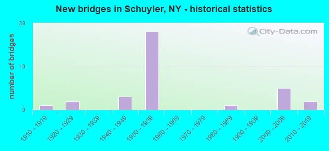
- New bridges - historical statistics
- 11910-1919
- 21920-1929
- 31940-1949
- 181950-1959
- 11980-1989
- 52000-2009
- 22010-2019

- Reconstructed bridges - Historical Statistics
- 11950-1959
- 01960-1969
- 01970-1979
- 51980-1989
- 01990-1999
- 32000-2009


- Bridge Condition - Deck
- 5.9%Excellent
- 11.8%Very good
- 23.5%Good
- 11.8%Satisfactory
- 23.5%Fair
- 23.5%Poor

- Bridge Condition - Superstructure
- 23.5%Excellent
- 11.8%Very good
- 23.5%Good
- 11.8%Satisfactory
- 29.4%Fair

- Bridge Condition - Substructure
- 5.9%Excellent
- 29.4%Very good
- 17.6%Good
- 11.8%Satisfactory
- 17.6%Fair
- 17.6%Poor

- Bridge Condition - Channel
- 5.6%Very good
- 5.6%Good
- 16.7%Satisfactory
- 38.9%Fair
- 33.3%Poor

- Bridge Condition - Culverts
- 12.5%Good
- 12.5%Satisfactory
- 62.5%Fair
- 12.5%Poor
Find on map >> Show street view
Structure Number: 100236, Location: IN SCHUYLER (Lat: 43.103436, Lng: -75.161250), Route carried "on" structure: State highway 5, Year Built: 1941, Status: Open, Structure Length: 1.16m (3.81ft), Average Daily Traffic: 7,829 (year 2020), Truck Traffic: 11%, Average Future Daily Traffic: 7,865 (year 2040), Design Load: HS 20, Features Intersected: BUDLONG CREEK
Minimum Vertical Clearance: 30+ m (98+ ft), Kilometerpoint: 0.692, Lanes on structure: 2, Base Highway Network: Yes, Owner: State Highway Agency, Approaching Roadway Width: 10.4m (34.1ft), Material/Design: Concrete continuous, Design/Construction: Culvert, Number Of Spans In Main Unit: 2, Length of Maximum Span: 4.2m (13.8ft), Curb-To-Curb Width: 10.8m (35.4ft), Out-to-Out Width: 11.6m (38.1ft)
Condition: Channel: Poor, Culverts: Fair, Operating Rating: 75.6 metric tons, Method Used To Determine Operating Rating: Field evaluation and documented engineering judgment, Inventory Rating: 32.7 metric tons, Method Used To Determine Inventory Rating: Field evaluation and documented engineering judgment, Structural Evaluation: Somewhat better than minimum adequacy, Deck Geometry: Meets minimum limits, Waterway Adequacy: Equal to present desirable criteria, Approach Roadway Alignment: Equal to present desirable criteria, Length Of Structure Improvement: 1.15m (3.77ft), Designated Inspection Frequency: Every 24 months, Inspection Date: April 2020, Bridge Improvement Cost: $371,000, Roadway Improvement Cost: $217,000, Total Project Cost: $588,000 ( Estimate for 2021), Wearing Surface/Protective System: Wearing Surface: Bituminous
Find on map >> Show street view
Structure Number: 100237, Location: IN WEST SCHUYLER (Lat: 43.094108, Lng: -75.140542), Route carried "on" structure: State highway 5, Year Built: 1941, Status: Open, Structure Length: 0.85m (2.79ft), Average Daily Traffic: 5,187 (year 2019), Truck Traffic: 9%, Average Future Daily Traffic: 5,211 (year 2040), Design Load: HS 20, Features Intersected: KNAPP BROOK
Minimum Vertical Clearance: 30+ m (98+ ft), Kilometerpoint: 2.687, Lanes on structure: 2, Base Highway Network: Yes, Owner: State Highway Agency, Approaching Roadway Width: 10.4m (34.1ft), Material/Design: Concrete continuous, Design/Construction: Culvert, Number Of Spans In Main Unit: 2, Length of Maximum Span: 3.7m (12.1ft), Curb-To-Curb Width: 10.5m (34.4ft), Out-to-Out Width: 11.6m (38.1ft)
Condition: Channel: Fair, Culverts: Good, Operating Rating: 75.1 metric tons, Method Used To Determine Operating Rating: Field evaluation and documented engineering judgment, Inventory Rating: 32.7 metric tons, Method Used To Determine Inventory Rating: Field evaluation and documented engineering judgment, Structural Evaluation: Better than present minimum criteria, Deck Geometry: Meets minimum limits, Waterway Adequacy: Equal to present desirable criteria, Approach Roadway Alignment: Equal to present desirable criteria, Length Of Structure Improvement: 0.85m (2.79ft), Designated Inspection Frequency: Every 24 months, Inspection Date: April 2020, Bridge Improvement Cost: $302,000, Roadway Improvement Cost: $177,000, Total Project Cost: $479,000 ( Estimate for 2021), Wearing Surface/Protective System: Wearing Surface: Bituminous
Find on map >> Show street view
Structure Number: 100238, Location: JCT I90 & SH 5 (Lat: 43.084828, Lng: -75.122642), Route carried "on" structure: State highway 5, Year Built: 1954, Year Reconstructed: 1994, Status: Open, Structure Length: 10.03m (32.91ft), Average Daily Traffic: 5,187 (year 2019), Truck Traffic: 9%, Average Future Daily Traffic: 5,211 (year 2040), Design Load: HS 20+Mod, Features Intersected: 90IX EB, RTE I90
Minimum Vertical Clearance: 30+ m (98+ ft), Kilometerpoint: 4.441, Lanes on structure: 2, Lanes under structure: 4, Base Highway Network: Yes, Owner: State Toll Authority, Maintenance Responsibility: State Highway Agency, Approaching Roadway Width: 12.2m (40.0ft), Skew: 5 degrees, Material/Design: Steel continuous, Design/Construction: Stringer/Multi-beam, Number Of Spans In Main Unit: 4, Length of Maximum Span: 28.7m (94.2ft), Curb-To-Curb Width: 12.1m (39.7ft), Out-to-Out Width: 13.0m (42.7ft)
Condition: Deck: Fair, Superstructure: Satisfactory, Substructure: Good, Operating Rating: 78.9 metric tons, Method Used To Determine Operating Rating: Load Factor (LF), Inventory Rating: 47.2 metric tons, Method Used To Determine Inventory Rating: Load Factor (LF), Structural Evaluation: Equal to present minimum criteria, Deck Geometry: Somewhat better than minimum adequacy, Underclear: High priority of corrective action, Approach Roadway Alignment: Equal to present desirable criteria, Length Of Structure Improvement: 10.02m (32.87ft), Designated Inspection Frequency: Every 24 months, Inspection Date: August 2020, Bridge Improvement Cost: $2,137,000, Roadway Improvement Cost: $1,252,000, Total Project Cost: $3,389,000 ( Estimate for 2021), Deck Structure Type: Concrete Cast-file-Place, Wearing Surface/Protective System: Wearing Surface: Integral Concrete, Deck Protection: Epoxy Coated Reinforcing
Find on map >> Show street view
Structure Number: 100239, Location: 5.6 MI W JCT RTS 5 & 51 (Lat: 43.076264, Lng: -75.112292), Route carried "on" structure: State highway 5, Year Built: 1929, Year Reconstructed: 2011, Status: Open, Structure Length: 2.35m (7.71ft), Average Daily Traffic: 5,187 (year 2019), Truck Traffic: 9%, Average Future Daily Traffic: 5,211 (year 2040), Design Load: HS 20, Features Intersected: STERLING CREEK
Minimum Vertical Clearance: 30+ m (98+ ft), Kilometerpoint: 5.792, Lanes on structure: 2, Base Highway Network: Yes, Owner: State Highway Agency, Approaching Roadway Width: 11.9m (39.0ft), Material/Design: Steel, Design/Construction: Girder and Floorbeam System, Number Of Spans In Main Unit: 1, Length of Maximum Span: 22.8m (74.8ft), Curb-To-Curb Width: 12.0m (39.4ft), Out-to-Out Width: 13.3m (43.6ft)
Condition: Deck: Good, Superstructure: Fair, Substructure: Satisfactory, Channel: Satisfactory, Operating Rating: 45.4 metric tons, Method Used To Determine Operating Rating: Load Factor (LF), Inventory Rating: 27.2 metric tons, Method Used To Determine Inventory Rating: Load Factor (LF), Structural Evaluation: Somewhat better than minimum adequacy, Deck Geometry: Somewhat better than minimum adequacy, Waterway Adequacy: Somewhat better than minimum adequacy, Approach Roadway Alignment: Equal to present desirable criteria, Length Of Structure Improvement: 2.34m (7.68ft), Designated Inspection Frequency: Every 24 months, Critical Feature Inspection Frequency: Every 24 months, Inspection Date: October 2020, Critical Feature Inspection Date: October 2020, Bridge Improvement Cost: $867,000, Roadway Improvement Cost: $508,000, Total Project Cost: $1,374,000 ( Estimate for 2021), Deck Structure Type: Concrete Cast-file-Place, Wearing Surface/Protective System: Wearing Surface: Monolithic Concrete
Find on map >> Show street view
Structure Number: 10024, Location: 3.5 MI W JCT SH 5 & CR 5 (Lat: 43.057222, Lng: -75.080156), Route carried "on" structure: State highway 5, Year Built: 1940, Status: Open, Structure Length: 0.94m (3.08ft), Average Daily Traffic: 5,187 (year 2019), Truck Traffic: 9%, Average Future Daily Traffic: 5,211 (year 2040), Design Load: HS 20, Features Intersected: BRIDENBECKER CRK
Minimum Vertical Clearance: 30+ m (98+ ft), Kilometerpoint: 9.139, Lanes on structure: 2, Base Highway Network: Yes, Owner: State Highway Agency, Approaching Roadway Width: 9.1m (29.9ft), Material/Design: Concrete continuous, Design/Construction: Culvert, Number Of Spans In Main Unit: 2, Length of Maximum Span: 4.0m (13.1ft), Curb-To-Curb Width: 10.9m (35.8ft), Out-to-Out Width: 11.6m (38.1ft)
Condition: Channel: Poor, Culverts: Fair, Operating Rating: 74.2 metric tons, Method Used To Determine Operating Rating: Field evaluation and documented engineering judgment, Inventory Rating: 19.6 metric tons, Method Used To Determine Inventory Rating: Field evaluation and documented engineering judgment, Structural Evaluation: Meets minimum limits, Deck Geometry: Meets minimum limits, Waterway Adequacy: Equal to present desirable criteria, Approach Roadway Alignment: Equal to present desirable criteria, Length Of Structure Improvement: 0.94m (3.08ft), Designated Inspection Frequency: Every 24 months, Inspection Date: March 2020, Bridge Improvement Cost: $213,000, Roadway Improvement Cost: $125,000, Total Project Cost: $338,000 ( Estimate for 2021), Wearing Surface/Protective System: Wearing Surface: Bituminous
Find on map >> Show street view
Structure Number: 330812, Location: 1.0 MI NE OF W SCHUYLER (Lat: 43.108758, Lng: -75.139992), Route carried "on" structure: County highway , Year Built: 1926, Status: Open, Structure Length: 0.70m (2.30ft), Average Daily Traffic: 705 (year 2017), Truck Traffic: 6%, Average Future Daily Traffic: 987 (year 2037), Features Intersected: WOOD CREEK, Facility Carried by Structure: CR243 COSBY MANOR
Minimum Vertical Clearance: 30+ m (98+ ft), Kilometerpoint: 0.209, Lanes on structure: 2, Owner: County Highway Agency, Approaching Roadway Width: 6.1m (20.0ft), Material/Design: Concrete, Design/Construction: Slab, Number Of Spans In Main Unit: 1, Length of Maximum Span: 6.0m (19.7ft), Curb-To-Curb Width: 7.4m (24.3ft), Out-to-Out Width: 8.4m (27.6ft)
Condition: Deck: Good, Superstructure: Good, Substructure: Good, Channel: Fair, Operating Rating: 58.1 metric tons, Method Used To Determine Operating Rating: Load Factor (LF), Inventory Rating: 35.4 metric tons, Method Used To Determine Inventory Rating: Load Factor (LF), Structural Evaluation: Better than present minimum criteria, Deck Geometry: Meets minimum limits, Waterway Adequacy: Meets minimum limits, Approach Roadway Alignment: Meets minimum limits, Length Of Structure Improvement: 0.70m (2.30ft), Designated Inspection Frequency: Every 24 months, Inspection Date: April 2021, Bridge Improvement Cost: $111,000, Roadway Improvement Cost: $65,000, Total Project Cost: $175,000 ( Estimate for 2021), Wearing Surface/Protective System: Wearing Surface: Bituminous
Find on map >> Show street view
Structure Number: 330813, Location: 3.4 MI E OF W SCHUYLER (Lat: 43.090956, Lng: -75.086506), Route carried "on" structure: County highway , Year Built: 2003, Status: Open, Structure Length: 3.14m (10.30ft), Average Daily Traffic: 303 (year 2017), Truck Traffic: 8%, Average Future Daily Traffic: 424 (year 2037), Design Load: HS 25 or greater, Features Intersected: STERLING CREEK, Facility Carried by Structure: CR53 SHORTLOTS ROA
Minimum Vertical Clearance: 30+ m (98+ ft), Kilometerpoint: 4.553, Lanes on structure: 2, Owner: County Highway Agency, Approaching Roadway Width: 8.5m (27.9ft), Skew: 1 degrees, Material/Design: Steel, Design/Construction: Stringer/Multi-beam, Number Of Spans In Main Unit: 1, Length of Maximum Span: 30.0m (98.4ft), Curb-To-Curb Width: 8.4m (27.6ft), Out-to-Out Width: 9.2m (30.2ft)
Condition: Deck: Very good, Superstructure: Excellent, Substructure: Very good, Channel: Fair, Inventory Rating: 60.8 metric tons, Method Used To Determine Inventory Rating: Load Factor (LF), Structural Evaluation: Equal to present desirable criteria, Deck Geometry: Somewhat better than minimum adequacy, Waterway Adequacy: Meets minimum limits, Approach Roadway Alignment: Equal to present desirable criteria, Length Of Structure Improvement: 3.13m (10.27ft), Designated Inspection Frequency: Every 24 months, Inspection Date: May 2021, Bridge Improvement Cost: $598,000, Roadway Improvement Cost: $350,000, Total Project Cost: $948,000 ( Estimate for 2021), Deck Structure Type: Concrete Cast-file-Place, Wearing Surface/Protective System: Wearing Surface: Integral Concrete, Deck Protection: Epoxy Coated Reinforcing
Find on map >> Show street view
Structure Number: 330814, Location: 5 MILES N OF FRANKFORT (Lat: 43.097267, Lng: -75.081856), Route carried "on" structure: County highway , Year Built: 2014, Status: Open, Structure Length: 2.62m (8.60ft), Average Daily Traffic: 71 (year 2017), Truck Traffic: 4%, Average Future Daily Traffic: 99 (year 2037), Design Load: HL 93, Features Intersected: STERLING CREEK, Facility Carried by Structure: CR180 BUSH ROAD
Minimum Vertical Clearance: 30+ m (98+ ft), Kilometerpoint: 0.853, Lanes on structure: 2, Owner: County Highway Agency, Approaching Roadway Width: 7.9m (25.9ft), Material/Design: Steel, Design/Construction: Stringer/Multi-beam, Number Of Spans In Main Unit: 1, Length of Maximum Span: 24.4m (80.1ft), Curb-To-Curb Width: 7.9m (25.9ft), Out-to-Out Width: 8.9m (29.2ft)
Condition: Deck: Excellent, Superstructure: Excellent, Substructure: Very good, Channel: Fair, Operating Rating: 78.0 metric tons, Method Used To Determine Operating Rating: Load Factor (LF), Inventory Rating: 46.3 metric tons, Method Used To Determine Inventory Rating: Load Factor (LF), Structural Evaluation: Equal to present desirable criteria, Deck Geometry: Equal to present minimum criteria, Waterway Adequacy: Equal to present minimum criteria, Approach Roadway Alignment: Better than present minimum criteria, Length Of Structure Improvement: 2.62m (8.60ft), Designated Inspection Frequency: Every 24 months, Inspection Date: October 2020, Bridge Improvement Cost: $533,000, Roadway Improvement Cost: $312,000, Total Project Cost: $845,000 ( Estimate for 2021), Deck Structure Type: Concrete Cast-file-Place, Wearing Surface/Protective System: Wearing Surface: Monolithic Concrete, Deck Protection: Galvanized Reinforcing
Find on map >> Show street view
Structure Number: 330815, Location: 6 MI N OF FRANKFORT (Lat: 43.107778, Lng: -75.072939), Route carried "on" structure: County highway , Year Built: 1958, Status: Open, Structure Length: 1.89m (6.20ft), Average Daily Traffic: 131 (year 2019), Truck Traffic: 8%, Average Future Daily Traffic: 183 (year 2039), Design Load: H 20, Features Intersected: STERLING CREEK, Facility Carried by Structure: CR197 MOWERS ROAD
Minimum Vertical Clearance: 30+ m (98+ ft), Kilometerpoint: 1.464, Lanes on structure: 2, Owner: County Highway Agency, Approaching Roadway Width: 5.2m (17.1ft), Material/Design: Prestressed concrete, Design/Construction: Box Beam or Girders - Multiple, Number Of Spans In Main Unit: 1, Length of Maximum Span: 17.6m (57.7ft), Curb or Sidewalk Widths: Left: 0.5m (1.6ft), Right: 0.5m (1.6ft), Curb-To-Curb Width: 7.4m (24.3ft), Out-to-Out Width: 9.0m (29.5ft)
Condition: Deck: Fair, Superstructure: Fair, Substructure: Fair, Channel: Fair, Operating Rating: 55.2 metric tons, Method Used To Determine Operating Rating: Field evaluation and documented engineering judgment, Inventory Rating: 20.1 metric tons, Method Used To Determine Inventory Rating: Field evaluation and documented engineering judgment, Structural Evaluation: Somewhat better than minimum adequacy, Deck Geometry: Somewhat better than minimum adequacy, Waterway Adequacy: Meets minimum limits, Approach Roadway Alignment: Equal to present desirable criteria, Length Of Structure Improvement: 1.88m (6.17ft), Designated Inspection Frequency: Every 24 months, Inspection Date: April 2021, Bridge Improvement Cost: $522,000, Roadway Improvement Cost: $305,000, Total Project Cost: $827,000 ( Estimate for 2021), Wearing Surface/Protective System: Wearing Surface: Bituminous
Find on map >> Show street view
Structure Number: 330816, Location: 3.7 MI NE OF W SCHUYLER (Lat: 43.122622, Lng: -75.086267), Route carried "on" structure: County highway , Year Built: 2013, Status: Open, Structure Length: 2.23m (7.32ft), Average Daily Traffic: 99 (year 2017), Truck Traffic: 4%, Average Future Daily Traffic: 139 (year 2037), Design Load: HL 93, Features Intersected: STERLING CREEK, Facility Carried by Structure: HAWTHORNE ROAD
Minimum Vertical Clearance: 30+ m (98+ ft), Kilometerpoint: 2.510, Lanes on structure: 2, Owner: County Highway Agency, Approaching Roadway Width: 7.9m (25.9ft), Material/Design: Steel, Design/Construction: Stringer/Multi-beam, Number Of Spans In Main Unit: 1, Length of Maximum Span: 21.3m (69.9ft), Curb-To-Curb Width: 7.9m (25.9ft), Out-to-Out Width: 8.9m (29.2ft)
Condition: Deck: Very good, Superstructure: Excellent, Substructure: Excellent, Channel: Fair, Operating Rating: 57.3 metric tons, Method Used To Determine Operating Rating: Load and Resistance Factor Rating (LRFR) rating reported by rating factor(RF) method using HL-93 loadings, Inventory Rating: 44.4 metric tons, Method Used To Determine Inventory Rating: Load and Resistance Factor Rating (LRFR) rating reported by rating factor(RF) method using HL-93 loadings, Structural Evaluation: Superior to present desirable criteria, Deck Geometry: Equal to present minimum criteria, Waterway Adequacy: Meets minimum limits, Approach Roadway Alignment: Better than present minimum criteria, Length Of Structure Improvement: 2.22m (7.28ft), Designated Inspection Frequency: Every 24 months, Inspection Date: November 2021, Bridge Improvement Cost: $380,000, Roadway Improvement Cost: $223,000, Total Project Cost: $603,000 ( Estimate for 2021), Deck Structure Type: Concrete Cast-file-Place, Wearing Surface/Protective System: Wearing Surface: Integral Concrete, Deck Protection: Galvanized Reinforcing
Find on map >> Show street view
Structure Number: 442305, Location: E SCHY OVER BARGE C (Lat: 43.051639, Lng: -75.076103), Route carried "on" structure: Other road , Year Built: 1910, Year Reconstructed: 1955, Status: Posted for load, Structure Length: 4.57m (14.99ft), Average Daily Traffic: 12 (year 2016), Average Future Daily Traffic: 17 (year 2036), Design Load: H 15, Features Intersected: ERIE BARGE CANAL, Facility Carried by Structure: MOSS ROAD
Minimum Vertical Clearance: 4.21m (13.81ft), Kilometerpoint: 0.274, Lanes on structure: 1, Owner: State Highway Agency, Approaching Roadway Width: 3.0m (9.8ft), Navigation Control: Yes ( Vertical Clearance: 6.7m (22.0ft), Horizontal Clearance: 13.1m (43.0ft)), Material/Design: Steel, Design/Construction: Truss - Thru, Number Of Spans In Main Unit: 1, Length of Maximum Span: 45.1m (148.0ft), Curb-To-Curb Width: 4.5m (14.8ft), Out-to-Out Width: 5.0m (16.4ft)
Condition: Deck: Good, Superstructure: Fair, Substructure: Fair, Channel: Good, Operating Rating: 3.6 metric tons, Method Used To Determine Operating Rating: Load and Resistance Factor Rating (LRFR) rating reported by rating factor(RF) method using HL-93 loadings, Inventory Rating: 2.9 metric tons, Method Used To Determine Inventory Rating: Load and Resistance Factor Rating (LRFR) rating reported by rating factor(RF) method using HL-93 loadings, Structural Evaluation: High priority of corrective action, Deck Geometry: High priority of corrective action, Waterway Adequacy: Somewhat better than minimum adequacy, Approach Roadway Alignment: High priority of replacement, Bridge Posting: Required (Relationship of Operating Rating to Maximum Legal Load: > 39.9% below), Length Of Structure Improvement: 4.57m (14.99ft), Designated Inspection Frequency: Every 12 months, Critical Feature Inspection Frequency: Every 12 months, Inspection Date: September 2021, Critical Feature Inspection Date: September 2021, Bridge Improvement Cost: $2,638,000, Roadway Improvement Cost: $1,545,000, Total Project Cost: $4,183,000 ( Estimate for 2021), Deck Structure Type: Open Grating, Wearing Surface/Protective System: Wearing Surface: Other
Find on map >> Show street view
Structure Number: 442306, Location: 1.1MI.E-W.CL.HERKIMER CO. (Lat: 43.093883, Lng: -75.155097), Route carried "on" structure: County highway , Year Built: 1981, Status: Open, Structure Length: 9.33m (30.61ft), Average Daily Traffic: 4,993 (year 2017), Truck Traffic: 6%, Average Future Daily Traffic: 6,065 (year 2040), Design Load: HS 20, Features Intersected: N Y S BARGE CANAL, Facility Carried by Structure: DYKE RD CO RD 37
Minimum Vertical Clearance: 30+ m (98+ ft), Kilometerpoint: 1.255, Lanes on structure: 2, Owner: County Highway Agency, Approaching Roadway Width: 13.4m (44.0ft), Navigation Control: Yes ( Vertical Clearance: 6.0m (19.7ft), Horizontal Clearance: 31.6m (103.7ft)), Material/Design: Steel continuous, Design/Construction: Stringer/Multi-beam, Number Of Spans In Main Unit: 3, Length of Maximum Span: 40.2m (131.9ft), Curb-To-Curb Width: 13.4m (44.0ft), Out-to-Out Width: 14.0m (45.9ft)
Condition: Deck: Good, Superstructure: Excellent, Substructure: Very good, Channel: Very good, Operating Rating: 49.6 metric tons, Method Used To Determine Operating Rating: Load and Resistance Factor Rating (LRFR) rating reported by rating factor(RF) method using HL-93 loadings, Inventory Rating: 38.2 metric tons, Method Used To Determine Inventory Rating: Load and Resistance Factor Rating (LRFR) rating reported by rating factor(RF) method using HL-93 loadings, Structural Evaluation: Equal to present desirable criteria, Deck Geometry: Better than present minimum criteria, Waterway Adequacy: Equal to present minimum criteria, Approach Roadway Alignment: Equal to present desirable criteria, Length Of Structure Improvement: 9.32m (30.58ft), Designated Inspection Frequency: Every 24 months, Underwater Inspection Frequency: Every 60 months, Inspection Date: August 2020, Underwater Inspection Date: May 2021, Bridge Improvement Cost: $1,931,000, Roadway Improvement Cost: $1,131,000, Total Project Cost: $3,062,000 ( Estimate for 2021), Deck Structure Type: Concrete Cast-file-Place, Wearing Surface/Protective System: Wearing Surface: Integral Concrete, Deck Protection: Epoxy Coated Reinforcing
Find on map >> Show street view
Structure Number: 5516051, Location: .3 MI E OF EAST SCHUYLER (Lat: 43.055564, Lng: -75.067297), Route carried "on" structure: Interstate 90, Year Built: 2004, Status: Open, Structure Length: 1.25m (4.10ft), Average Daily Traffic: 11,303 (year 2014), Truck Traffic: 7%, Design Load: HS 25 or greater, Features Intersected: WATKINS RD CR 211
Minimum Vertical Clearance: 30+ m (98+ ft), Kilometerpoint: 361.623, Lanes on structure: 2, Lanes under structure: 2, Base Highway Network: Yes, Toll: On Interstate toll segment, Owner: State Toll Authority, Approaching Roadway Width: 15.8m (51.8ft), Skew: 1 degrees, Material/Design: Steel, Design/Construction: Stringer/Multi-beam, Number Of Spans In Main Unit: 1, Length of Maximum Span: 11.6m (38.1ft), Curb-To-Curb Width: 15.8m (51.8ft), Out-to-Out Width: 16.8m (55.1ft)
Condition: Deck: Satisfactory, Superstructure: Very good, Substructure: Very good, Operating Rating: 78.9 metric tons, Method Used To Determine Operating Rating: Load Factor (LF), Inventory Rating: 47.2 metric tons, Method Used To Determine Inventory Rating: Load Factor (LF), Structural Evaluation: Equal to present desirable criteria, Deck Geometry: Superior to present desirable criteria, Underclear: Meets minimum limits, Approach Roadway Alignment: Equal to present desirable criteria, Length Of Structure Improvement: 1.24m (4.07ft), Designated Inspection Frequency: Every 24 months, Inspection Date: October 2021, Bridge Improvement Cost: $951,000, Roadway Improvement Cost: $557,000, Total Project Cost: $1,508,000 ( Estimate for 2021), Deck Structure Type: Concrete Cast-file-Place, Wearing Surface/Protective System: Wearing Surface: Integral Concrete, Deck Protection: Galvanized Reinforcing
Find on map >> Show street view
Structure Number: 5516052, Location: .3 MI E OF EAST SCHUYLER (Lat: 43.055342, Lng: -75.067467), Route carried "on" structure: Interstate 90, Year Built: 2004, Status: Open, Structure Length: 1.25m (4.10ft), Average Daily Traffic: 9,611 (year 2020), Truck Traffic: 30%, Average Future Daily Traffic: 11,074 (year 2040), Design Load: HS 25 or greater, Features Intersected: WATKINS RD CR 211
Minimum Vertical Clearance: 30+ m (98+ ft), Kilometerpoint: 10.040, Lanes on structure: 2, Lanes under structure: 2, Base Highway Network: Yes, Toll: On Interstate toll segment, Owner: State Toll Authority, Approaching Roadway Width: 15.8m (51.8ft), Skew: 1 degrees, Material/Design: Steel, Design/Construction: Stringer/Multi-beam, Number Of Spans In Main Unit: 1, Length of Maximum Span: 11.6m (38.1ft), Curb-To-Curb Width: 15.8m (51.8ft), Out-to-Out Width: 16.8m (55.1ft)
Condition: Deck: Satisfactory, Superstructure: Very good, Substructure: Very good, Operating Rating: 78.9 metric tons, Method Used To Determine Operating Rating: Load Factor (LF), Inventory Rating: 47.2 metric tons, Method Used To Determine Inventory Rating: Load Factor (LF), Structural Evaluation: Equal to present desirable criteria, Deck Geometry: Superior to present desirable criteria, Underclear: Meets minimum limits, Approach Roadway Alignment: Equal to present desirable criteria, Length Of Structure Improvement: 1.24m (4.07ft), Designated Inspection Frequency: Every 24 months, Inspection Date: October 2021, Bridge Improvement Cost: $951,000, Roadway Improvement Cost: $557,000, Total Project Cost: $1,508,000 ( Estimate for 2021), Deck Structure Type: Concrete Cast-file-Place, Wearing Surface/Protective System: Wearing Surface: Integral Concrete, Deck Protection: Galvanized Reinforcing
Find on map >> Show street view
Structure Number: 551606, Location: 7.4 MI E I-90 INT 31 (Lat: 43.061683, Lng: -75.077939), Route carried "on" structure: Interstate 90, Year Built: 1954, Year Reconstructed: 2000, Status: Open, Structure Length: 0.76m (2.49ft), Average Daily Traffic: 19,222 (year 2020), Truck Traffic: 30%, Average Future Daily Traffic: 22,147 (year 2040), Design Load: HS 25 or greater, Features Intersected: BRIDENBAKER CREEK
Minimum Vertical Clearance: 30+ m (98+ ft), Kilometerpoint: 8.930, Lanes on structure: 4, Base Highway Network: Yes, Toll: On Interstate toll segment, Owner: State Toll Authority, Approaching Roadway Width: 33.8m (110.9ft), Skew: 21 degrees, Material/Design: Concrete, Design/Construction: Culvert, Number Of Spans In Main Unit: 2, Length of Maximum Span: 3.0m (9.8ft)
Condition: Channel: Poor, Culverts: Satisfactory, Operating Rating: 74.8 metric tons, Method Used To Determine Operating Rating: Field evaluation and documented engineering judgment, Inventory Rating: 40.8 metric tons, Method Used To Determine Inventory Rating: Field evaluation and documented engineering judgment, Structural Evaluation: Equal to present minimum criteria, Waterway Adequacy: Meets minimum limits, Approach Roadway Alignment: Equal to present desirable criteria, Length Of Structure Improvement: 0.76m (2.49ft), Designated Inspection Frequency: Every 24 months, Inspection Date: September 2020, Bridge Improvement Cost: $829,000, Roadway Improvement Cost: $486,000, Total Project Cost: $1,315,000 ( Estimate for 2021)
Find on map >> Show street view
Structure Number: 5516071, Location: 7.4 MI E RTE I-90 INT 31 (Lat: 43.062389, Lng: -75.078675), Route carried "on" structure: Interstate 90, Year Built: 1954, Year Reconstructed: 1994, Status: Open, Structure Length: 1.07m (3.51ft), Average Daily Traffic: 11,303 (year 2014), Truck Traffic: 7%, Design Load: HS 20+Mod, Features Intersected: CR 53, Millers Grove Roa
Minimum Vertical Clearance: 30+ m (98+ ft), Kilometerpoint: 362.813, Lanes on structure: 2, Lanes under structure: 2, Base Highway Network: Yes, Toll: On Interstate toll segment, Owner: State Toll Authority, Approaching Roadway Width: 11.3m (37.1ft), Material/Design: Steel, Design/Construction: Stringer/Multi-beam, Number Of Spans In Main Unit: 1, Length of Maximum Span: 9.8m (32.2ft), Curb-To-Curb Width: 15.9m (52.2ft), Out-to-Out Width: 17.0m (55.8ft)
Condition: Deck: Poor, Superstructure: Satisfactory, Substructure: Poor, Operating Rating: 40.8 metric tons, Method Used To Determine Operating Rating: Load Factor (LF), Inventory Rating: 23.6 metric tons, Method Used To Determine Inventory Rating: Load Factor (LF), Structural Evaluation: Meets minimum limits, Deck Geometry: Superior to present desirable criteria, Underclear: Meets minimum limits, Approach Roadway Alignment: Equal to present desirable criteria, Length Of Structure Improvement: 1.06m (3.48ft), Designated Inspection Frequency: Every 24 months, Inspection Date: April 2021, Bridge Improvement Cost: $829,000, Roadway Improvement Cost: $485,000, Total Project Cost: $1,314,000 ( Estimate for 2021), Deck Structure Type: Concrete Cast-file-Place, Wearing Surface/Protective System: Wearing Surface: Bituminous, Membrane: Other
Find on map >> Show street view
Structure Number: 5516072, Location: 7.4 MI E RTE I-90 INT 31 (Lat: 43.062200, Lng: -75.078883), Route carried "on" structure: Interstate 90, Year Built: 1954, Year Reconstructed: 1994, Status: Open, Structure Length: 1.07m (3.51ft), Average Daily Traffic: 9,611 (year 2020), Truck Traffic: 30%, Average Future Daily Traffic: 11,074 (year 2040), Design Load: HS 20+Mod, Features Intersected: CR 53, Millers Grove Roa
Minimum Vertical Clearance: 30+ m (98+ ft), Kilometerpoint: 8.833, Lanes on structure: 2, Lanes under structure: 2, Base Highway Network: Yes, Toll: On Interstate toll segment, Owner: State Toll Authority, Approaching Roadway Width: 11.3m (37.1ft), Material/Design: Steel, Design/Construction: Stringer/Multi-beam, Number Of Spans In Main Unit: 1, Length of Maximum Span: 9.8m (32.2ft), Curb-To-Curb Width: 15.9m (52.2ft), Out-to-Out Width: 17.0m (55.8ft)
Condition: Deck: Poor, Superstructure: Fair, Substructure: Poor, Operating Rating: 46.3 metric tons, Method Used To Determine Operating Rating: Load Factor (LF), Inventory Rating: 29.0 metric tons, Method Used To Determine Inventory Rating: Load Factor (LF), Structural Evaluation: Meets minimum limits, Deck Geometry: Superior to present desirable criteria, Underclear: Meets minimum limits, Approach Roadway Alignment: Equal to present desirable criteria, Length Of Structure Improvement: 1.06m (3.48ft), Designated Inspection Frequency: Every 24 months, Inspection Date: April 2021, Bridge Improvement Cost: $813,000, Roadway Improvement Cost: $476,000, Total Project Cost: $1,290,000 ( Estimate for 2021), Deck Structure Type: Concrete Cast-file-Place, Wearing Surface/Protective System: Wearing Surface: Bituminous, Membrane: Other
Find on map >> Show street view
Structure Number: 551608, Location: 1.8 MI NE OF E. SCHUYLER (Lat: 43.072417, Lng: -75.097661), Route carried "on" structure: County highway , Year Built: 1954, Status: Open, Structure Length: 8.69m (28.51ft), Average Daily Traffic: 219 (year 2016), Truck Traffic: 4%, Average Future Daily Traffic: 307 (year 2036), Design Load: HS 20+Mod, Features Intersected: 90IX EB, RTE I90, Facility Carried by Structure: CR 11 CARDER LANE
Minimum Vertical Clearance: 30+ m (98+ ft), Kilometerpoint: 0.644, Lanes on structure: 2, Lanes under structure: 4, Owner: State Toll Authority, Approaching Roadway Width: 7.3m (24.0ft), Skew: 3 degrees, Material/Design: Steel, Design/Construction: Stringer/Multi-beam, Number Of Spans In Main Unit: 4, Length of Maximum Span: 26.2m (86.0ft), Curb or Sidewalk Widths: Left: 0.8m (2.6ft), Right: 0.8m (2.6ft), Curb-To-Curb Width: 7.3m (24.0ft), Out-to-Out Width: 9.4m (30.8ft)
Condition: Deck: Fair, Superstructure: Good, Substructure: Good, Operating Rating: 49.9 metric tons, Method Used To Determine Operating Rating: Load and Resistance Factor Rating (LRFR) rating reported by rating factor(RF) method using HL-93 loadings, Inventory Rating: 38.6 metric tons, Method Used To Determine Inventory Rating: Load and Resistance Factor Rating (LRFR) rating reported by rating factor(RF) method using HL-93 loadings, Structural Evaluation: Better than present minimum criteria, Deck Geometry: Somewhat better than minimum adequacy, Underclear: High priority of corrective action, Approach Roadway Alignment: Equal to present desirable criteria, Length Of Structure Improvement: 8.68m (28.48ft), Designated Inspection Frequency: Every 24 months, Inspection Date: June 2021, Bridge Improvement Cost: $1,299,000, Roadway Improvement Cost: $761,000, Total Project Cost: $2,060,000 ( Estimate for 2021), Deck Structure Type: Concrete Cast-file-Place, Wearing Surface/Protective System: Wearing Surface: Monolithic Concrete
Find on map >> Show street view
Structure Number: 5516091, Location: 2.5 MI NE OF E. SCHUYLER (Lat: 43.078883, Lng: -75.109003), Route carried "on" structure: Interstate 90, Year Built: 1954, Year Reconstructed: 1994, Status: Open, Structure Length: 2.56m (8.40ft), Average Daily Traffic: 11,303 (year 2014), Truck Traffic: 7%, Design Load: HS 20+Mod, Features Intersected: STERLING CREEK
Minimum Vertical Clearance: 30+ m (98+ ft), Kilometerpoint: 365.903, Lanes on structure: 2, Base Highway Network: Yes, Toll: On Interstate toll segment, Owner: State Toll Authority, Approaching Roadway Width: 11.9m (39.0ft), Skew: 1 degrees, Material/Design: Steel, Design/Construction: Stringer/Multi-beam, Number Of Spans In Main Unit: 1, Length of Maximum Span: 24.7m (81.0ft), Curb-To-Curb Width: 15.9m (52.2ft), Out-to-Out Width: 17.0m (55.8ft)
Condition: Deck: Poor, Superstructure: Good, Substructure: Satisfactory, Channel: Satisfactory, Operating Rating: 66.2 metric tons, Method Used To Determine Operating Rating: Load Factor (LF), Inventory Rating: 35.4 metric tons, Method Used To Determine Inventory Rating: Load Factor (LF), Structural Evaluation: Equal to present minimum criteria, Deck Geometry: Superior to present desirable criteria, Waterway Adequacy: Meets minimum limits, Approach Roadway Alignment: Equal to present desirable criteria, Length Of Structure Improvement: 2.56m (8.40ft), Designated Inspection Frequency: Every 24 months, Inspection Date: May 2021, Bridge Improvement Cost: $1,168,000, Roadway Improvement Cost: $684,000, Total Project Cost: $1,851,000 ( Estimate for 2021), Deck Structure Type: Concrete Cast-file-Place, Wearing Surface/Protective System: Wearing Surface: Bituminous, Membrane: Other
Find on map >> Show street view
Structure Number: 5516092, Location: 2.5 MI NE OF E. SCHUYLER (Lat: 43.078719, Lng: -75.109256), Route carried "on" structure: Interstate 90, Year Built: 1954, Year Reconstructed: 1994, Status: Open, Structure Length: 2.56m (8.40ft), Average Daily Traffic: 9,611 (year 2020), Truck Traffic: 30%, Average Future Daily Traffic: 11,074 (year 2040), Design Load: HS 20+Mod, Features Intersected: STERLING CREEK
Minimum Vertical Clearance: 30+ m (98+ ft), Kilometerpoint: 5.760, Lanes on structure: 2, Base Highway Network: Yes, Toll: On Interstate toll segment, Owner: State Toll Authority, Approaching Roadway Width: 11.9m (39.0ft), Skew: 1 degrees, Material/Design: Steel, Design/Construction: Stringer/Multi-beam, Number Of Spans In Main Unit: 1, Length of Maximum Span: 24.7m (81.0ft), Curb-To-Curb Width: 15.9m (52.2ft), Out-to-Out Width: 17.0m (55.8ft)
Condition: Deck: Poor, Superstructure: Good, Substructure: Poor, Channel: Satisfactory, Operating Rating: 57.2 metric tons, Method Used To Determine Operating Rating: Load Factor (LF), Inventory Rating: 26.3 metric tons, Method Used To Determine Inventory Rating: Load Factor (LF), Structural Evaluation: Meets minimum limits, Deck Geometry: Superior to present desirable criteria, Waterway Adequacy: Meets minimum limits, Approach Roadway Alignment: Equal to present desirable criteria, Length Of Structure Improvement: 2.56m (8.40ft), Designated Inspection Frequency: Every 24 months, Inspection Date: May 2021, Bridge Improvement Cost: $1,168,000, Roadway Improvement Cost: $684,000, Total Project Cost: $1,851,000 ( Estimate for 2021), Deck Structure Type: Concrete Cast-file-Place, Wearing Surface/Protective System: Wearing Surface: Bituminous, Membrane: Other
Find on map >> Show street view
Structure Number: 55161, Location: 4.3 MI E RTE I-90 INT 31 (Lat: 43.087008, Lng: -75.128639), Route carried "on" structure: Interstate 90, Year Built: 1954, Status: Open, Structure Length: 0.81m (2.66ft), Average Daily Traffic: 19,222 (year 2020), Truck Traffic: 30%, Average Future Daily Traffic: 22,147 (year 2040), Design Load: HS 20+Mod, Features Intersected: BURCH CREEK
Minimum Vertical Clearance: 30+ m (98+ ft), Kilometerpoint: 3.926, Lanes on structure: 4, Base Highway Network: Yes, Toll: On Interstate toll segment, Owner: State Toll Authority, Approaching Roadway Width: 27.4m (89.9ft), Skew: 22 degrees, Material/Design: Concrete, Design/Construction: Culvert, Number Of Spans In Main Unit: 2, Length of Maximum Span: 4.0m (13.1ft)
Condition: Channel: Poor, Culverts: Fair, Operating Rating: 33.7 metric tons, Method Used To Determine Operating Rating: Load and Resistance Factor Rating (LRFR) rating reported by rating factor(RF) method using HL-93 loadings, Inventory Rating: 25.9 metric tons, Method Used To Determine Inventory Rating: Load and Resistance Factor Rating (LRFR) rating reported by rating factor(RF) method using HL-93 loadings, Structural Evaluation: Somewhat better than minimum adequacy, Waterway Adequacy: Meets minimum limits, Approach Roadway Alignment: Equal to present desirable criteria, Length Of Structure Improvement: 0.88m (2.89ft), Designated Inspection Frequency: Every 24 months, Inspection Date: April 2021, Bridge Improvement Cost: $425,000, Roadway Improvement Cost: $249,000, Total Project Cost: $674,000 ( Estimate for 2021), Wearing Surface/Protective System: Wearing Surface: Bituminous
Find on map >> Show street view
Structure Number: 551611, Location: 0.6 MI SW OF W. SCHUYLER (Lat: 43.092681, Lng: -75.141153), Route carried "on" structure: Interstate 90, Year Built: 1954, Status: Open, Structure Length: 0.78m (2.56ft), Average Daily Traffic: 19,222 (year 2020), Truck Traffic: 30%, Average Future Daily Traffic: 22,147 (year 2040), Design Load: HS 20+Mod, Features Intersected: KNAPP CREEK
Minimum Vertical Clearance: 30+ m (98+ ft), Kilometerpoint: 2.735, Lanes on structure: 4, Base Highway Network: Yes, Toll: On Interstate toll segment, Owner: State Toll Authority, Approaching Roadway Width: 27.4m (89.9ft), Skew: 21 degrees, Material/Design: Concrete, Design/Construction: Culvert, Number Of Spans In Main Unit: 2, Length of Maximum Span: 3.7m (12.1ft)
Condition: Channel: Poor, Culverts: Poor, Operating Rating: 72.6 metric tons, Method Used To Determine Operating Rating: Load Factor (LF), Inventory Rating: 43.5 metric tons, Method Used To Determine Inventory Rating: Load Factor (LF), Structural Evaluation: Meets minimum limits, Waterway Adequacy: Meets minimum limits, Approach Roadway Alignment: Equal to present desirable criteria, Length Of Structure Improvement: 0.85m (2.79ft), Designated Inspection Frequency: Every 24 months, Inspection Date: April 2021, Bridge Improvement Cost: $410,000, Roadway Improvement Cost: $240,000, Total Project Cost: $650,000 ( Estimate for 2021), Wearing Surface/Protective System: Wearing Surface: Bituminous
Find on map >> Show street view
Structure Number: 551612, Location: 0.2 MI SE OF W. SCHUYLER (Lat: 43.095617, Lng: -75.148503), Route carried "on" structure: Interstate 90, Year Built: 1954, Status: Open, Structure Length: 0.64m (2.10ft), Average Daily Traffic: 19,222 (year 2020), Truck Traffic: 30%, Average Future Daily Traffic: 22,147 (year 2040), Design Load: HS 20+Mod, Features Intersected: WOODS CREEK
Minimum Vertical Clearance: 30+ m (98+ ft), Kilometerpoint: 2.043, Lanes on structure: 4, Base Highway Network: Yes, Toll: On Interstate toll segment, Owner: State Toll Authority, Approaching Roadway Width: 24.7m (81.0ft), Skew: 21 degrees, Material/Design: Concrete, Design/Construction: Culvert, Number Of Spans In Main Unit: 1, Length of Maximum Span: 6.1m (20.0ft)
Condition: Channel: Poor, Culverts: Fair, Operating Rating: 76.9 metric tons, Method Used To Determine Operating Rating: Field evaluation and documented engineering judgment, Inventory Rating: 32.7 metric tons, Method Used To Determine Inventory Rating: Field evaluation and documented engineering judgment, Structural Evaluation: Somewhat better than minimum adequacy, Waterway Adequacy: Meets minimum limits, Approach Roadway Alignment: Equal to present desirable criteria, Length Of Structure Improvement: 0.64m (2.10ft), Designated Inspection Frequency: Every 24 months, Inspection Date: May 2020, Bridge Improvement Cost: $486,000, Roadway Improvement Cost: $285,000, Total Project Cost: $771,000 ( Estimate for 2021)
Find on map >> Show street view
Structure Number: 551613, Location: 2.9 MI E RTE I-90 INT 31 (Lat: 43.097111, Lng: -75.152067), Route carried "on" structure: County highway , Year Built: 1954, Status: Open, Structure Length: 6.52m (21.39ft), Average Daily Traffic: 4,993 (year 2017), Truck Traffic: 6%, Average Future Daily Traffic: 6,065 (year 2040), Design Load: HS 20+Mod, Features Intersected: 90IX EB, RTE I90, Facility Carried by Structure: DYKE RD CR 37
Minimum Vertical Clearance: 30+ m (98+ ft), Kilometerpoint: 1.706, Lanes on structure: 2, Lanes under structure: 4, Owner: State Toll Authority, Approaching Roadway Width: 9.8m (32.2ft), Material/Design: Steel, Design/Construction: Stringer/Multi-beam, Number Of Spans In Main Unit: 4, Length of Maximum Span: 20.7m (67.9ft), Curb-To-Curb Width: 7.9m (25.9ft), Out-to-Out Width: 10.1m (33.1ft)
Condition: Deck: Fair, Superstructure: Fair, Substructure: Fair, Operating Rating: 59.0 metric tons, Method Used To Determine Operating Rating: Load Factor (LF), Inventory Rating: 35.4 metric tons, Method Used To Determine Inventory Rating: Load Factor (LF), Structural Evaluation: Somewhat better than minimum adequacy, Deck Geometry: High priority of corrective action, Underclear: High priority of corrective action, Approach Roadway Alignment: Equal to present desirable criteria, Length Of Structure Improvement: 6.52m (21.39ft), Designated Inspection Frequency: Every 24 months, Inspection Date: September 2021, Bridge Improvement Cost: $1,050,000, Roadway Improvement Cost: $615,000, Total Project Cost: $1,665,000 ( Estimate for 2021), Deck Structure Type: Concrete Cast-file-Place, Wearing Surface/Protective System: Wearing Surface: Bituminous, Membrane: Other
Find on map >> Show street view
Structure Number: 551614, Location: 0.7 MI NW OF W. SCHUYLER (Lat: 43.102517, Lng: -75.163069), Route carried "on" structure: Interstate 90, Year Built: 1954, Year Reconstructed: 2007, Status: Open, Structure Length: 0.98m (3.22ft), Average Daily Traffic: 19,222 (year 2020), Truck Traffic: 30%, Average Future Daily Traffic: 22,147 (year 2040), Design Load: HS 20+Mod, Features Intersected: BUDLONG CREEK
Minimum Vertical Clearance: 30+ m (98+ ft), Kilometerpoint: 0.628, Lanes on structure: 4, Base Highway Network: Yes, Toll: On Interstate toll segment, Owner: State Toll Authority, Approaching Roadway Width: 24.4m (80.1ft), Skew: 22 degrees, Material/Design: Concrete, Design/Construction: Culvert, Number Of Spans In Main Unit: 2, Length of Maximum Span: 4.6m (15.1ft)
Condition: Channel: Fair, Culverts: Fair, Operating Rating: 75.5 metric tons, Method Used To Determine Operating Rating: Field evaluation and documented engineering judgment, Inventory Rating: 29.4 metric tons, Method Used To Determine Inventory Rating: Field evaluation and documented engineering judgment, Structural Evaluation: Somewhat better than minimum adequacy, Waterway Adequacy: Meets minimum limits, Approach Roadway Alignment: Equal to present desirable criteria, Length Of Structure Improvement: 0.97m (3.18ft), Designated Inspection Frequency: Every 24 months, Inspection Date: May 2020, Bridge Improvement Cost: $648,000, Roadway Improvement Cost: $379,000, Total Project Cost: $1,027,000 ( Estimate for 2021)
Find on map >> Show street view
Structure Number: 100238, Location: JCT I90 & SH 5 (Lat: 43.084828, Lng: -75.122642), Route carried "under" structure: Interstate 90, Year Built: 1954, Structure Length: 0. m, Average Daily Traffic: 12,200 (year 1979), Features Intersected: 90IX EB, RTE I90, Facility Carried by Structure: RTE 5
Minimum Vertical Clearance: 4.70m (15.42ft), Kilometerpoint: 367.174, Lanes on structure: 2, Lanes under structure: 2, Toll: On Interstate toll segment, Material/Design: Steel continuous, Design/Construction: Stringer/Multi-beam, Length of Maximum Span: 28.7m (94.2ft)
Find on map >> Show street view
Structure Number: 5516051, Location: .3 MI E OF EAST SCHUYLER (Lat: 43.055564, Lng: -75.067297), Route carried "under" structure: County highway , Year Built: 2004, Structure Length: 0. m, Features Intersected: WATKINS RD CR 211, Facility Carried by Structure: RTE I90
Minimum Vertical Clearance: 4.72m (15.49ft), Kilometerpoint: 0.451, Lanes on structure: 2, Lanes under structure: 2, Material/Design: Steel, Design/Construction: Stringer/Multi-beam, Length of Maximum Span: 11.6m (38.1ft)
Find on map >> Show street view
Structure Number: 5516052, Location: .3 MI E OF EAST SCHUYLER (Lat: 43.055342, Lng: -75.067467), Route carried "under" structure: County highway , Year Built: 2004, Structure Length: 0. m, Features Intersected: WATKINS RD CR 211, Facility Carried by Structure: RTE I90
Minimum Vertical Clearance: 5.72m (18.77ft), Kilometerpoint: 0.000, Lanes on structure: 2, Lanes under structure: 2, Material/Design: Steel, Design/Construction: Stringer/Multi-beam, Length of Maximum Span: 11.6m (38.1ft)
Find on map >> Show street view
Structure Number: 5516071, Location: 7.4 MI E RTE I-90 INT 31 (Lat: 43.062389, Lng: -75.078675), Route carried "under" structure: County highway , Year Built: 1954, Structure Length: 0. m, Average Daily Traffic: 160 (year 2018), Truck Traffic: 10%, Features Intersected: CR 53, Millers Grove Roa, Facility Carried by Structure: RTE I90
Minimum Vertical Clearance: 4.37m (14.34ft), Kilometerpoint: 9.670, Lanes on structure: 2, Lanes under structure: 2, Material/Design: Steel, Design/Construction: Stringer/Multi-beam, Length of Maximum Span: 9.8m (32.2ft)
Find on map >> Show street view
Structure Number: 5516072, Location: 7.4 MI E RTE I-90 INT 31 (Lat: 43.062200, Lng: -75.078883), Route carried "under" structure: County highway , Year Built: 1954, Structure Length: 0. m, Average Daily Traffic: 160 (year 2018), Truck Traffic: 10%, Features Intersected: CR 53, Millers Grove Roa, Facility Carried by Structure: RTE I90
Minimum Vertical Clearance: 4.65m (15.26ft), Kilometerpoint: 9.702, Lanes on structure: 2, Lanes under structure: 2, Material/Design: Steel, Design/Construction: Stringer/Multi-beam, Length of Maximum Span: 9.8m (32.2ft)
Find on map >> Show street view
Structure Number: 551608, Location: 1.8 MI NE OF E. SCHUYLER (Lat: 43.072417, Lng: -75.097661), Route carried "under" structure: Interstate 90, Year Built: 1954, Structure Length: 0. m, Average Daily Traffic: 22,549 (year 2015), Features Intersected: 90IX EB, RTE I90, Facility Carried by Structure: CR 11 CARDER LANE
Minimum Vertical Clearance: 4.55m (14.93ft), Kilometerpoint: 364.728, Lanes on structure: 2, Lanes under structure: 2, Toll: On Interstate toll segment, Material/Design: Steel, Design/Construction: Stringer/Multi-beam, Length of Maximum Span: 26.2m (86.0ft)
Find on map >> Show street view
Structure Number: 551613, Location: 2.9 MI E RTE I-90 INT 31 (Lat: 43.097111, Lng: -75.152067), Route carried "under" structure: Interstate 90, Year Built: 1954, Structure Length: 0. m, Average Daily Traffic: 22,549 (year 2015), Features Intersected: 90IX EB, RTE I90, Facility Carried by Structure: DYKE RD CR 37
Minimum Vertical Clearance: 4.55m (14.93ft), Kilometerpoint: 369.941, Lanes on structure: 2, Lanes under structure: 2, Toll: On Interstate toll segment, Material/Design: Steel, Design/Construction: Stringer/Multi-beam, Length of Maximum Span: 20.7m (67.9ft)