Bridge Statistics for Shark River Hills, New Jersey (NJ)
Condition, Traffic, Stress, Structural Evaluation, Project Costs
- National Bridge Inventory (NBI) Statistics
- 15Number of bridges
- 177ft / 54.2mTotal length
- $5,856,000Total costs
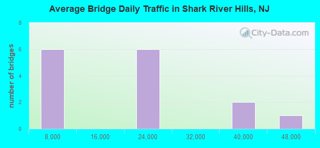
- 273,286Total average daily traffic
- 12,788Total average daily truck traffic
- National Bridge Inventory (NBI) Registered Bridges for Shark River Hills
- No street view available for this location
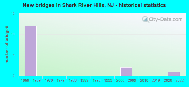
- New bridges - historical statistics
- 121960-1969
- 22000-2009
- 12020-2022
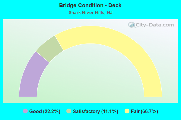
- Bridge Condition - Deck
- 22.2%Good
- 11.1%Satisfactory
- 66.7%Fair
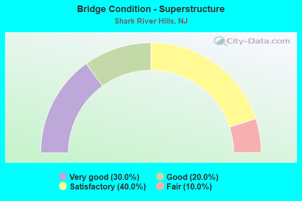
- Bridge Condition - Superstructure
- 30.0%Very good
- 20.0%Good
- 40.0%Satisfactory
- 10.0%Fair
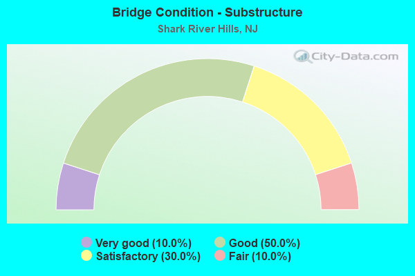
- Bridge Condition - Substructure
- 10.0%Very good
- 50.0%Good
- 30.0%Satisfactory
- 10.0%Fair
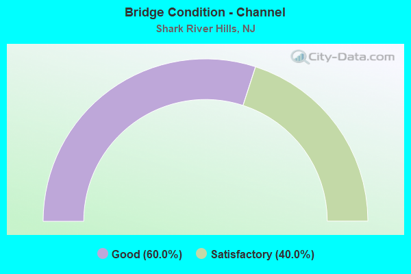
- Bridge Condition - Channel
- 60.0%Good
- 40.0%Satisfactory
Find on map >> Show street view
Structure Number: 13000N5, Location: 0.6 MI.SW OF JCT NJ 33 (Lat: 40.203111, Lng: -74.064550), Route carried "on" structure: County highway 17, Year Built: 2001, Status: Open, Structure Length: 6.10m (20.01ft), Average Daily Traffic: 2,066 (year 2021), Truck Traffic: 3%, Average Future Daily Traffic: 2,521 (year 2041), Design Load: HS 25 or greater, Features Intersected: JUMPING BROOK
Minimum Vertical Clearance: 30+ m (98+ ft), Kilometerpoint: 0.789, Lanes on structure: 2, Owner: County Highway Agency, Approaching Roadway Width: 9.1m (29.9ft), Material/Design: Prestressed concrete continuous, Design/Construction: Stringer/Multi-beam, Number Of Spans In Main Unit: 3, Length of Maximum Span: 20.1m (65.9ft), Curb or Sidewalk Widths: Left: 1.5m (4.9ft), Right: 0.3m (1.0ft), Curb-To-Curb Width: 9.1m (29.9ft), Out-to-Out Width: 11.5m (37.7ft)
Condition: Deck: Good, Superstructure: Very good, Substructure: Good, Channel: Good, Inventory Rating: 47.2 metric tons, Method Used To Determine Inventory Rating: Load Factor (LF), Structural Evaluation: Better than present minimum criteria, Deck Geometry: Meets minimum limits, Waterway Adequacy: Superior to present desirable criteria, Approach Roadway Alignment: Somewhat better than minimum adequacy, Designated Inspection Frequency: Every 24 months, Inspection Date: May 2021, Deck Structure Type: Concrete Cast-file-Place, Wearing Surface/Protective System: Wearing Surface: Monolithic Concrete, Deck Protection: Galvanized Reinforcing
Find on map >> Show street view
Structure Number: 1300W35, Location: 1/4 MILE EAST OF NJ 18 (Lat: 40.191331, Lng: -74.059389), Route carried "on" structure: City street , Year Built: 2006, Status: Open, Structure Length: 3.11m (10.20ft), Average Daily Traffic: 6,422 (year 2021), Truck Traffic: 3%, Average Future Daily Traffic: 7,836 (year 2041), Design Load: HL 93, Features Intersected: SHARK RIVER, Facility Carried by Structure: BRIGHTON AVENUE
Minimum Vertical Clearance: 30+ m (98+ ft), Kilometerpoint: 1.609, Lanes on structure: 2, Owner: County Highway Agency, Approaching Roadway Width: 10.1m (33.1ft), Material/Design: Prestressed concrete, Design/Construction: Slab, Number Of Spans In Main Unit: 3, Length of Maximum Span: 9.8m (32.2ft), Curb or Sidewalk Widths: Left: 0.5m (1.6ft), Right: 0.5m (1.6ft), Curb-To-Curb Width: 10.1m (33.1ft), Out-to-Out Width: 11.1m (36.4ft)
Condition: Deck: Good, Superstructure: Very good, Substructure: Good, Channel: Good, Operating Rating: 59.9 metric tons, Method Used To Determine Operating Rating: Load and Resistance Factor Rating (LRFR) rating reported by rating factor(RF) method using HL-93 loadings, Inventory Rating: 46.3 metric tons, Method Used To Determine Inventory Rating: Load and Resistance Factor Rating (LRFR) rating reported by rating factor(RF) method using HL-93 loadings, Structural Evaluation: Better than present minimum criteria, Deck Geometry: Meets minimum limits, Waterway Adequacy: Better than present minimum criteria, Approach Roadway Alignment: Equal to present desirable criteria, Designated Inspection Frequency: Every 24 months, Underwater Inspection Frequency: Every 48 months, Inspection Date: May 2021, Underwater Inspection Date: June 2019, Deck Structure Type: Concrete Cast-file-Place, Wearing Surface/Protective System: Wearing Surface: Monolithic Concrete, Deck Protection: Epoxy Coated Reinforcing
Find on map >> Show street view
Structure Number: 1300W36, Location: 1 MI. SO. N.J. RTE.33 (Lat: 40.198669, Lng: -74.069839), Route carried "on" structure: City street , Year Built: 2021, Status: Not yet open, Structure Length: 1.04m (3.41ft), Average Daily Traffic: 920 (year 2021), Truck Traffic: 1%, Average Future Daily Traffic: 1,100 (year 2041), Design Load: HL 93, Features Intersected: SHARK RIVER, Facility Carried by Structure: REMSON MILL ROAD
Minimum Vertical Clearance: 30+ m (98+ ft), Kilometerpoint: 0.000, Lanes on structure: 2, Owner: County Highway Agency, Maintenance Responsibility: City or Municipal Highway Agency, Approaching Roadway Width: 9.2m (30.2ft), Material/Design: Concrete, Design/Construction: Frame, Number Of Spans In Main Unit: 1, Length of Maximum Span: 9.8m (32.2ft), Curb or Sidewalk Widths: Left: 0.1m (0.3ft), Right: 1.8m (5.9ft), Curb-To-Curb Width: 9.2m (30.2ft), Out-to-Out Width: 11.9m (39.0ft)
Condition: Superstructure: Very good, Substructure: Very good, Channel: Satisfactory, Operating Rating: 54.4 metric tons, Method Used To Determine Operating Rating: Field evaluation and documented engineering judgment, Inventory Rating: 32.7 metric tons, Method Used To Determine Inventory Rating: Field evaluation and documented engineering judgment, Structural Evaluation: Equal to present desirable criteria, Deck Geometry: Equal to present minimum criteria, Waterway Adequacy: Superior to present desirable criteria, Approach Roadway Alignment: Equal to present minimum criteria, Length Of Structure Improvement: 1.58m (5.18ft), Designated Inspection Frequency: Every 24 months, Inspection Date: April 2021, Bridge Improvement Cost: $1,035,000, Roadway Improvement Cost: $155,000, Total Project Cost: $1,775,000 ( Estimate for 2019)
Find on map >> Show street view
Structure Number: 1327159, Location: .3 MILES NORTH OF JCT 138 (Lat: 40.176119, Lng: -74.072719), Route carried "on" structure: City street , Year Built: 1968, Status: Open, Structure Length: 8.81m (28.90ft), Average Daily Traffic: 1,248 (year 2021), Truck Traffic: 1%, Average Future Daily Traffic: 1,522 (year 2041), Design Load: HS 20, Features Intersected: NJ ROUTE 18, Facility Carried by Structure: MONMOUTH BLVD
Minimum Vertical Clearance: 30+ m (98+ ft), Kilometerpoint: 0.000, Lanes on structure: 2, Lanes under structure: 4, Owner: State Highway Agency, Approaching Roadway Width: 9.1m (29.9ft), Skew: 4 degrees, Material/Design: Steel, Design/Construction: Stringer/Multi-beam, Number Of Spans In Main Unit: 4, Length of Maximum Span: 30.8m (101.0ft), Curb or Sidewalk Widths: Left: 1.8m (5.9ft), Right: 1.8m (5.9ft), Curb-To-Curb Width: 9.1m (29.9ft), Out-to-Out Width: 13.4m (44.0ft)
Condition: Deck: Fair, Superstructure: Satisfactory, Substructure: Good, Operating Rating: 70.8 metric tons, Method Used To Determine Operating Rating: Load Factor (LF), Inventory Rating: 41.7 metric tons, Method Used To Determine Inventory Rating: Load Factor (LF), Structural Evaluation: Equal to present minimum criteria, Deck Geometry: Somewhat better than minimum adequacy, Underclear: High priority of corrective action, Approach Roadway Alignment: Equal to present minimum criteria, Length Of Structure Improvement: 8.81m (28.90ft), Designated Inspection Frequency: Every 24 months, Inspection Date: June 2021, Roadway Improvement Cost: $784,000, Total Project Cost: $78,000 ( Estimate for 2021), Deck Structure Type: Concrete Cast-file-Place, Wearing Surface/Protective System: Wearing Surface: Monolithic Concrete
Find on map >> Show street view
Structure Number: 132716, Location: 0.85 MI N OF RT 138 JCT (Lat: 40.183319, Lng: -74.073339), Route carried "on" structure: County highway 18, Year Built: 1967, Status: Open, Structure Length: 6.61m (21.69ft), Average Daily Traffic: 5,276 (year 2021), Truck Traffic: 4%, Average Future Daily Traffic: 6,438 (year 2041), Design Load: HS 20, Features Intersected: ROUTE 18, Facility Carried by Structure: BELMAR BLVD
Minimum Vertical Clearance: 30+ m (98+ ft), Kilometerpoint: 8.562, Lanes on structure: 2, Lanes under structure: 4, Owner: State Highway Agency, Approaching Roadway Width: 12.2m (40.0ft), Skew: 3 degrees, Material/Design: Steel, Design/Construction: Stringer/Multi-beam, Number Of Spans In Main Unit: 2, Length of Maximum Span: 31.7m (104.0ft), Curb or Sidewalk Widths: Left: 1.8m (5.9ft), Right: 1.8m (5.9ft), Curb-To-Curb Width: 9.1m (29.9ft), Out-to-Out Width: 13.4m (44.0ft)
Condition: Deck: Fair, Superstructure: Good, Substructure: Satisfactory, Operating Rating: 56.2 metric tons, Method Used To Determine Operating Rating: Load Factor (LF), Inventory Rating: 33.6 metric tons, Method Used To Determine Inventory Rating: Load Factor (LF), Structural Evaluation: Equal to present minimum criteria, Deck Geometry: Meets minimum limits, Underclear: High priority of corrective action, Approach Roadway Alignment: Equal to present desirable criteria, Length Of Structure Improvement: 6.61m (21.69ft), Designated Inspection Frequency: Every 24 months, Inspection Date: June 2021, Bridge Improvement Cost: $821,000, Roadway Improvement Cost: $143,000, Total Project Cost: $1,109,000 ( Estimate for 2021), Deck Structure Type: Concrete Cast-file-Place, Wearing Surface/Protective System: Wearing Surface: Monolithic Concrete
Find on map >> Show street view
Structure Number: 1327161, Location: 1.7 MI N OF 18 & 138 JCT (Lat: 40.190481, Lng: -74.068350), Route carried "on" structure: City street , Year Built: 1967, Status: Open, Structure Length: 11.83m (38.81ft), Average Daily Traffic: 6,719 (year 2021), Truck Traffic: 3%, Average Future Daily Traffic: 8,199 (year 2041), Design Load: HS 20+Mod, Features Intersected: ROUTE 18, Facility Carried by Structure: BRIGHTON AVENUE
Minimum Vertical Clearance: 30+ m (98+ ft), Kilometerpoint: 2.334, Lanes on structure: 2, Lanes under structure: 5, Owner: State Highway Agency, Approaching Roadway Width: 12.2m (40.0ft), Skew: 5 degrees, Material/Design: Steel, Design/Construction: Stringer/Multi-beam, Number Of Spans In Main Unit: 4, Length of Maximum Span: 42.4m (139.1ft), Curb or Sidewalk Widths: Left: 1.8m (5.9ft), Right: 0.5m (1.6ft), Curb-To-Curb Width: 9.1m (29.9ft), Out-to-Out Width: 12.0m (39.4ft)
Condition: Deck: Satisfactory, Superstructure: Good, Substructure: Good, Operating Rating: 53.5 metric tons, Method Used To Determine Operating Rating: Load Factor (LF), Inventory Rating: 31.8 metric tons, Method Used To Determine Inventory Rating: Load Factor (LF), Structural Evaluation: Better than present minimum criteria, Deck Geometry: Meets minimum limits, Underclear: Somewhat better than minimum adequacy, Approach Roadway Alignment: Equal to present desirable criteria, Designated Inspection Frequency: Every 24 months, Inspection Date: June 2021, Deck Structure Type: Concrete Cast-file-Place, Wearing Surface/Protective System: Wearing Surface: Monolithic Concrete
Find on map >> Show street view
Structure Number: 1327162, Location: 1.88 Mi N of NJ 138 Jct. (Lat: 40.192961, Lng: -74.059969), Route carried "on" structure: State highway 18, Year Built: 1968, Status: Open, Structure Length: 3.54m (11.61ft), Average Daily Traffic: 23,657 (year 2021), Truck Traffic: 5%, Average Future Daily Traffic: 28,866 (year 2041), Design Load: HS 20+Mod, Features Intersected: Shark River
Minimum Vertical Clearance: 30+ m (98+ ft), Kilometerpoint: 11.684, Lanes on structure: 3, Base Highway Network: Yes, Owner: State Highway Agency, Approaching Roadway Width: 12.2m (40.0ft), Navigation Control: Yes ( Vertical Clearance: 3.0m (9.8ft), Horizontal Clearance: 7.3m (24.0ft)), Material/Design: Prestressed concrete, Design/Construction: Box Beam or Girders - Multiple, Number Of Spans In Main Unit: 4, Length of Maximum Span: 9.1m (29.9ft), Curb or Sidewalk Widths: Left: 0.5m (1.6ft), Right: 0.5m (1.6ft), Curb-To-Curb Width: 12.2m (40.0ft), Out-to-Out Width: 13.6m (44.6ft)
Condition: Deck: Fair, Superstructure: Satisfactory, Substructure: Satisfactory, Channel: Good, Operating Rating: 56.2 metric tons, Method Used To Determine Operating Rating: Load Factor (LF), Inventory Rating: 33.6 metric tons, Method Used To Determine Inventory Rating: Load Factor (LF), Structural Evaluation: Equal to present minimum criteria, Deck Geometry: High priority of replacement, Waterway Adequacy: Equal to present desirable criteria, Approach Roadway Alignment: Equal to present desirable criteria, Length Of Structure Improvement: 3.54m (11.61ft), Designated Inspection Frequency: Every 24 months, Underwater Inspection Frequency: Every 48 months, Inspection Date: May 2021, Underwater Inspection Date: April 2021, Bridge Improvement Cost: $522,000, Roadway Improvement Cost: $100,000, Total Project Cost: $840,000 ( Estimate for 2021), Deck Structure Type: Concrete Cast-file-Place, Wearing Surface/Protective System: Wearing Surface: Monolithic Concrete
Find on map >> Show street view
Structure Number: 1327163, Location: 1.0 MI SOUTH OF RT 33 JCT (Lat: 40.193439, Lng: -74.059931), Route carried "on" structure: State highway 18, Year Built: 1968, Status: Open, Structure Length: 3.54m (11.61ft), Average Daily Traffic: 21,138 (year 2020), Truck Traffic: 5%, Average Future Daily Traffic: 25,793 (year 2040), Design Load: HS 20, Features Intersected: SHARK RIVER
Minimum Vertical Clearance: 30+ m (98+ ft), Kilometerpoint: 11.684, Lanes on structure: 2, Base Highway Network: Yes, Owner: State Highway Agency, Approaching Roadway Width: 11.9m (39.0ft), Material/Design: Prestressed concrete, Design/Construction: Box Beam or Girders - Multiple, Number Of Spans In Main Unit: 4, Length of Maximum Span: 9.1m (29.9ft), Curb-To-Curb Width: 11.9m (39.0ft), Out-to-Out Width: 13.6m (44.6ft)
Condition: Deck: Fair, Superstructure: Satisfactory, Substructure: Fair, Channel: Satisfactory, Operating Rating: 57.2 metric tons, Method Used To Determine Operating Rating: Load Factor (LF), Inventory Rating: 34.5 metric tons, Method Used To Determine Inventory Rating: Load Factor (LF), Structural Evaluation: Somewhat better than minimum adequacy, Deck Geometry: Equal to present minimum criteria, Waterway Adequacy: Superior to present desirable criteria, Approach Roadway Alignment: Better than present minimum criteria, Designated Inspection Frequency: Every 24 months, Underwater Inspection Frequency: Every 48 months, Inspection Date: July 2020, Underwater Inspection Date: July 2020, Deck Structure Type: Concrete Cast-file-Place, Wearing Surface/Protective System: Wearing Surface: Latex Concrete
Find on map >> Show street view
Structure Number: 132815, Location: 1.56 Mi. South of NJ 66 (Lat: 40.205989, Lng: -74.052619), Route carried "on" structure: State highway 18, Year Built: 1965, Status: Open, Structure Length: 4.79m (15.72ft), Average Daily Traffic: 21,135 (year 2020), Truck Traffic: 5%, Average Future Daily Traffic: 29,839 (year 2040), Design Load: HS 20, Features Intersected: NJ 33
Minimum Vertical Clearance: 30+ m (98+ ft), Kilometerpoint: 13.325, Lanes on structure: 3, Lanes under structure: 6, Base Highway Network: Yes, Owner: State Highway Agency, Approaching Roadway Width: 12.2m (40.0ft), Material/Design: Steel, Design/Construction: Stringer/Multi-beam, Number Of Spans In Main Unit: 3, Length of Maximum Span: 30.2m (99.1ft), Curb-To-Curb Width: 12.2m (40.0ft), Out-to-Out Width: 13.8m (45.3ft)
Condition: Deck: Fair, Superstructure: Satisfactory, Substructure: Satisfactory, Operating Rating: 58.1 metric tons, Method Used To Determine Operating Rating: Load Factor (LF), Inventory Rating: 34.5 metric tons, Method Used To Determine Inventory Rating: Load Factor (LF), Structural Evaluation: Equal to present minimum criteria, Deck Geometry: High priority of replacement, Underclear: Equal to present minimum criteria, Approach Roadway Alignment: Better than present minimum criteria, Length Of Structure Improvement: 4.79m (15.72ft), Designated Inspection Frequency: Every 24 months, Inspection Date: August 2020, Bridge Improvement Cost: $710,000, Roadway Improvement Cost: $43,000, Total Project Cost: $1,051,000 ( Estimate for 2020), Deck Structure Type: Concrete Cast-file-Place, Wearing Surface/Protective System: Wearing Surface: Monolithic Concrete
Find on map >> Show street view
Structure Number: 1328151, Location: 1.56 Mi. South of NJ 66 (Lat: 40.206489, Lng: -74.052969), Route carried "on" structure: State highway 18, Year Built: 1965, Status: Open, Structure Length: 4.79m (15.72ft), Average Daily Traffic: 21,138 (year 2020), Truck Traffic: 5%, Average Future Daily Traffic: 25,816 (year 2040), Design Load: HS 20, Features Intersected: NJ 33
Minimum Vertical Clearance: 30+ m (98+ ft), Kilometerpoint: 13.325, Lanes on structure: 3, Lanes under structure: 6, Base Highway Network: Yes, Owner: State Highway Agency, Approaching Roadway Width: 12.2m (40.0ft), Material/Design: Steel, Design/Construction: Stringer/Multi-beam, Number Of Spans In Main Unit: 3, Length of Maximum Span: 30.2m (99.1ft), Curb-To-Curb Width: 12.2m (40.0ft), Out-to-Out Width: 13.8m (45.3ft)
Condition: Deck: Fair, Superstructure: Fair, Substructure: Good, Operating Rating: 58.1 metric tons, Method Used To Determine Operating Rating: Load Factor (LF), Inventory Rating: 34.5 metric tons, Method Used To Determine Inventory Rating: Load Factor (LF), Structural Evaluation: Somewhat better than minimum adequacy, Deck Geometry: High priority of replacement, Underclear: Equal to present minimum criteria, Approach Roadway Alignment: Equal to present desirable criteria, Length Of Structure Improvement: 4.79m (15.72ft), Designated Inspection Frequency: Every 24 months, Inspection Date: August 2020, Bridge Improvement Cost: $673,000, Roadway Improvement Cost: $45,000, Total Project Cost: $1,003,000 ( Estimate for 2020), Deck Structure Type: Concrete Cast-file-Place, Wearing Surface/Protective System: Wearing Surface: Monolithic Concrete
Find on map >> Show street view
Structure Number: 1327159, Location: .3 MILES NORTH OF JCT 138 (Lat: 40.176119, Lng: -74.072719), Route carried "under" structure: State highway 18, Year Built: 1968, Structure Length: 0. m, Average Daily Traffic: 42,289 (year 2021), Truck Traffic: 5%, Features Intersected: NJ ROUTE 18, Facility Carried by Structure: MONMOUTH BLVD
Minimum Vertical Clearance: 4.60m (15.09ft), Kilometerpoint: 9.205, Lanes on structure: 2, Lanes under structure: 4, Material/Design: Steel, Design/Construction: Stringer/Multi-beam, Length of Maximum Span: 30.8m (101.0ft)
Find on map >> Show street view
Structure Number: 132716, Location: 0.85 MI N OF RT 138 JCT (Lat: 40.183319, Lng: -74.073339), Route carried "under" structure: State highway 18, Year Built: 1967, Structure Length: 0. m, Average Daily Traffic: 39,529 (year 2021), Truck Traffic: 5%, Features Intersected: ROUTE 18, Facility Carried by Structure: BELMAR BLVD
Minimum Vertical Clearance: 4.78m (15.68ft), Kilometerpoint: 10.026, Lanes on structure: 2, Lanes under structure: 4, Material/Design: Steel, Design/Construction: Stringer/Multi-beam, Length of Maximum Span: 31.7m (104.0ft)
Find on map >> Show street view
Structure Number: 1327161, Location: 1.7 MI N OF 18 & 138 JCT (Lat: 40.190481, Lng: -74.068350), Route carried "under" structure: State highway 18, Year Built: 1967, Structure Length: 0. m, Average Daily Traffic: 39,301 (year 2021), Truck Traffic: 5%, Features Intersected: ROUTE 18, Facility Carried by Structure: BRIGHTON AVENUE
Minimum Vertical Clearance: 6.20m (20.34ft), Kilometerpoint: 10.976, Lanes on structure: 2, Lanes under structure: 5, Material/Design: Steel, Design/Construction: Stringer/Multi-beam, Length of Maximum Span: 42.4m (139.1ft)
Find on map >> Show street view
Structure Number: 132815, Location: 1.56 Mi. South of NJ 66 (Lat: 40.205989, Lng: -74.052619), Route carried "under" structure: State highway 33, Year Built: 1965, Structure Length: 0. m, Average Daily Traffic: 21,226 (year 2020), Truck Traffic: 4%, Features Intersected: NJ 33, Facility Carried by Structure: NJ 18 NB
Minimum Vertical Clearance: 6.15m (20.18ft), Kilometerpoint: 64.422, Lanes on structure: 3, Lanes under structure: 6, Material/Design: Steel, Design/Construction: Stringer/Multi-beam, Length of Maximum Span: 30.2m (99.1ft)
Find on map >> Show street view
Structure Number: 1328151, Location: 1.56 Mi. South of NJ 66 (Lat: 40.206489, Lng: -74.052969), Route carried "under" structure: State highway 33, Year Built: 1965, Structure Length: 0. m, Average Daily Traffic: 21,222 (year 2020), Truck Traffic: 4%, Features Intersected: NJ 33, Facility Carried by Structure: NJ 18 SB
Minimum Vertical Clearance: 5.16m (16.93ft), Kilometerpoint: 64.390, Lanes on structure: 3, Lanes under structure: 6, Material/Design: Steel, Design/Construction: Stringer/Multi-beam, Length of Maximum Span: 30.2m (99.1ft)