Bridge Statistics for Sinking Spring, Pennsylvania (PA)
Condition, Traffic, Stress, Structural Evaluation, Project Costs
- National Bridge Inventory (NBI) Statistics
- 15Number of bridges
- 118ft / 35.8mTotal length
- $2,417,000Total costs
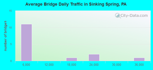
- 105,454Total average daily traffic
- 9,550Total average daily truck traffic
- 117,929Total future (year 1999) average daily traffic
- National Bridge Inventory (NBI) Registered Bridges for Sinking Spring
- No street view available for this location
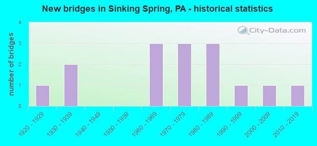
- New bridges - historical statistics
- 11920-1929
- 21930-1939
- 31960-1969
- 31970-1979
- 31980-1989
- 11990-1999
- 12000-2009
- 12010-2019
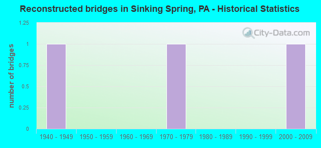
- Reconstructed bridges - Historical Statistics
- 11940-1949
- 01950-1959
- 01960-1969
- 11970-1979
- 01980-1989
- 01990-1999
- 12000-2009
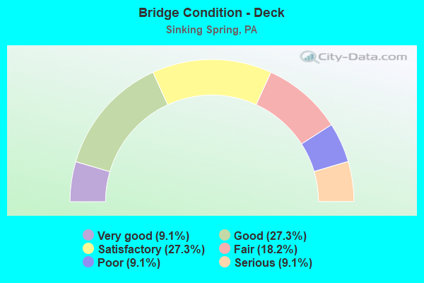
- Bridge Condition - Deck
- 9.1%Very good
- 27.3%Good
- 27.3%Satisfactory
- 18.2%Fair
- 9.1%Poor
- 9.1%Serious
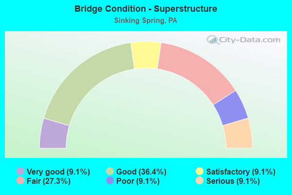
- Bridge Condition - Superstructure
- 9.1%Very good
- 36.4%Good
- 9.1%Satisfactory
- 27.3%Fair
- 9.1%Poor
- 9.1%Serious
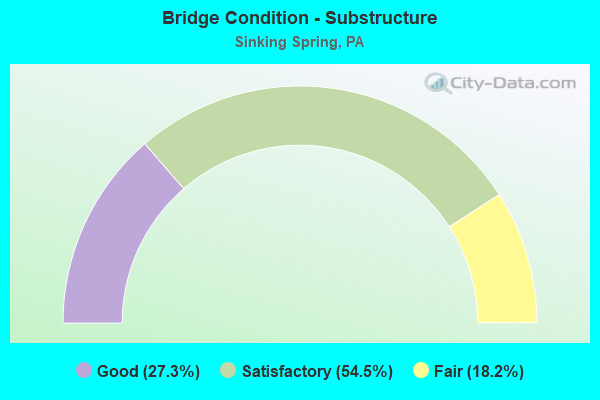
- Bridge Condition - Substructure
- 27.3%Good
- 54.5%Satisfactory
- 18.2%Fair
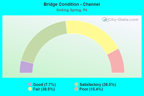
- Bridge Condition - Channel
- 7.7%Good
- 38.5%Satisfactory
- 38.5%Fair
- 15.4%Poor
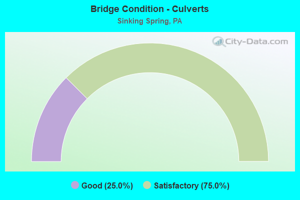
- Bridge Condition - Culverts
- 25.0%Good
- 75.0%Satisfactory
Find on map >> Show street view
Structure Number: 291, Location: 3.5 MI.S.W. OF GETTYSBURG (Lat: 39.798808, Lng: -77.278547), Route carried "on" structure: State highway , Year Built: 1963, Status: Open, Structure Length: 5.52m (18.11ft), Average Daily Traffic: 726 (year 2022), Truck Traffic: 6%, Average Future Daily Traffic: 1,084 (year 2032), Design Load: HS 20, Features Intersected: MARSH CREEK, Facility Carried by Structure: PUMPING STATION RD
Minimum Vertical Clearance: 30+ m (98+ ft), Kilometerpoint: 11.402, Lanes on structure: 2, Owner: State Highway Agency, Approaching Roadway Width: 6.1m (20.0ft), Skew: 2 degrees, Material/Design: Prestressed concrete, Design/Construction: Box Beam or Girders - Single/Spread, Number Of Spans In Main Unit: 3, Length of Maximum Span: 18.3m (60.0ft), Curb or Sidewalk Widths: Left: 0.5m (1.6ft), Right: 0.5m (1.6ft), Curb-To-Curb Width: 8.5m (27.9ft), Out-to-Out Width: 10.2m (33.5ft)
Condition: Deck: Fair, Superstructure: Satisfactory, Substructure: Satisfactory, Channel: Fair, Operating Rating: 78.0 metric tons, Method Used To Determine Operating Rating: Load Factor (LF), Inventory Rating: 31.8 metric tons, Method Used To Determine Inventory Rating: Load Factor (LF), Structural Evaluation: Equal to present minimum criteria, Deck Geometry: Somewhat better than minimum adequacy, Waterway Adequacy: Better than present minimum criteria, Approach Roadway Alignment: Equal to present desirable criteria, Length Of Structure Improvement: 6.50m (21.33ft), Designated Inspection Frequency: Every 24 months, Underwater Inspection Frequency: Every 60 months, Inspection Date: April 2021, Underwater Inspection Date: July 2020, Bridge Improvement Cost: $27,000, Roadway Improvement Cost: $78,000, Total Project Cost: $359,000, Deck Structure Type: Concrete Cast-file-Place, Wearing Surface/Protective System: Wearing Surface: Bituminous, Membrane: Preformed Fabric
Find on map >> Show street view
Structure Number: 292, Location: 3 MI. S.W. OF GETTYSBURG (Lat: 39.800853, Lng: -77.266861), Route carried "on" structure: State highway , Year Built: 1963, Status: Posted for load, Structure Length: 2.19m (7.19ft), Average Daily Traffic: 726 (year 2022), Truck Traffic: 6%, Average Future Daily Traffic: 1,084 (year 2032), Design Load: HS 20, Features Intersected: WILLOUGHBY RUN, Facility Carried by Structure: SR 3005
Minimum Vertical Clearance: 30+ m (98+ ft), Kilometerpoint: 12.397, Lanes on structure: 2, Owner: State Highway Agency, Approaching Roadway Width: 9.8m (32.2ft), Material/Design: Prestressed concrete, Design/Construction: Box Beam or Girders - Multiple, Number Of Spans In Main Unit: 1, Length of Maximum Span: 20.7m (67.9ft), Curb or Sidewalk Widths: Left: 0.4m (1.3ft), Right: 0.4m (1.3ft), Curb-To-Curb Width: 8.6m (28.2ft), Out-to-Out Width: 10.3m (33.8ft)
Condition: Deck: Poor, Superstructure: Poor, Substructure: Fair, Channel: Fair, Operating Rating: 34.5 metric tons, Method Used To Determine Operating Rating: Load Factor (LF), Inventory Rating: 13.6 metric tons, Method Used To Determine Inventory Rating: Load Factor (LF), Structural Evaluation: Meets minimum limits, Deck Geometry: Somewhat better than minimum adequacy, Waterway Adequacy: Equal to present desirable criteria, Approach Roadway Alignment: Equal to present desirable criteria, Bridge Posting: Required (Relationship of Operating Rating to Maximum Legal Load: 10.0 - 19.9% below), Length Of Structure Improvement: 2.90m (9.51ft), Designated Inspection Frequency: Every 24 months, Other Special Inspection Frequency: Every 12 months, Inspection Date: March 2021, Other Special Inspection Date: March 2021, Deck Structure Type: Other, Wearing Surface/Protective System: Wearing Surface: Bituminous
Find on map >> Show street view
Structure Number: 648, Location: TARENTUM INTERCHANGE (Lat: 40.612683, Lng: -79.758225), Route carried "on" structure: State highway 28, Year Built: 1982, Status: Open, Structure Length: 1.07m (3.51ft), Average Daily Traffic: 33,192 (year 2020), Truck Traffic: 11%, Average Future Daily Traffic: 30,905 (year 2032), Design Load: HS 20, Features Intersected: BULL CREEK, Facility Carried by Structure: ALLEGHENY VALLE EX
Minimum Vertical Clearance: 30+ m (98+ ft), Kilometerpoint: 30.030, Lanes on structure: 6, Base Highway Network: Yes, Owner: State Highway Agency, Approaching Roadway Width: 37.8m (124.0ft), Skew: 20 degrees, Material/Design: Concrete, Design/Construction: Culvert, Number Of Spans In Main Unit: 1, Length of Maximum Span: 10.7m (35.1ft)
Condition: Channel: Fair, Culverts: Satisfactory, Operating Rating: 49.0 metric tons, Method Used To Determine Operating Rating: Field evaluation and documented engineering judgment, Inventory Rating: 32.7 metric tons, Method Used To Determine Inventory Rating: Field evaluation and documented engineering judgment, Structural Evaluation: Equal to present minimum criteria, Waterway Adequacy: Superior to present desirable criteria, Approach Roadway Alignment: Equal to present desirable criteria, Length Of Structure Improvement: 1.90m (6.23ft), Designated Inspection Frequency: Every 48 months, Inspection Date: September 2021
Find on map >> Show street view
Structure Number: 649, Location: TARENTUM INTERCHANGE (Lat: 40.613325, Lng: -79.757250), Route carried "on" structure: State highway 28, Year Built: 1984, Status: Open, Structure Length: 4.63m (15.19ft), Average Daily Traffic: 14,781 (year 2020), Truck Traffic: 12%, Average Future Daily Traffic: 11,357 (year 2032), Design Load: HS 20, Features Intersected: SR 1034 -BULL CREEK ROAD
Minimum Vertical Clearance: 30+ m (98+ ft), Kilometerpoint: 30.819, Lanes on structure: 2, Lanes under structure: 14, Base Highway Network: Yes, Owner: State Highway Agency, Approaching Roadway Width: 12.8m (42.0ft), Skew: 11 degrees, Material/Design: Prestressed concrete, Design/Construction: Box Beam or Girders - Multiple, Number Of Spans In Main Unit: 3, Length of Maximum Span: 31.1m (102.0ft), Curb or Sidewalk Widths: Left: 0.2m (0.7ft), Right: 0.2m (0.7ft), Curb-To-Curb Width: 12.8m (42.0ft), Out-to-Out Width: 13.7m (44.9ft)
Condition: Deck: Good, Superstructure: Good, Substructure: Satisfactory, Inventory Rating: 20.9 metric tons, Method Used To Determine Inventory Rating: Load Factor (LF), Structural Evaluation: Somewhat better than minimum adequacy, Deck Geometry: Equal to present desirable criteria, Underclear: Equal to present minimum criteria, Approach Roadway Alignment: Equal to present desirable criteria, Length Of Structure Improvement: 4.60m (15.09ft), Designated Inspection Frequency: Every 24 months, Inspection Date: June 2021, Bridge Improvement Cost: $17,000, Roadway Improvement Cost: $50,000, Total Project Cost: $228,000, Deck Structure Type: Concrete Cast-file-Place, Wearing Surface/Protective System: Wearing Surface: Monolithic Concrete, Deck Protection: Epoxy Coated Reinforcing
Find on map >> Show street view
Structure Number: 65, Location: TARENTUM INTERCHANGE (Lat: 40.613403, Lng: -79.757472), Route carried "on" structure: State highway 28, Year Built: 1984, Status: Open, Structure Length: 4.63m (15.19ft), Average Daily Traffic: 18,411 (year 2020), Truck Traffic: 11%, Average Future Daily Traffic: 19,548 (year 2032), Design Load: HS 20, Features Intersected: SR 1034-BULL CREEK ROAD
Minimum Vertical Clearance: 30+ m (98+ ft), Kilometerpoint: 30.785, Lanes on structure: 3, Lanes under structure: 8, Base Highway Network: Yes, Owner: State Highway Agency, Approaching Roadway Width: 20.7m (67.9ft), Skew: 11 degrees, Material/Design: Prestressed concrete, Design/Construction: Box Beam or Girders - Multiple, Number Of Spans In Main Unit: 3, Length of Maximum Span: 31.1m (102.0ft), Curb or Sidewalk Widths: Left: 0.2m (0.7ft), Right: 0.2m (0.7ft), Curb-To-Curb Width: 20.7m (67.9ft), Out-to-Out Width: 21.6m (70.9ft)
Condition: Deck: Satisfactory, Superstructure: Good, Substructure: Satisfactory, Inventory Rating: 64.4 metric tons, Method Used To Determine Inventory Rating: Load Factor (LF), Structural Evaluation: Equal to present minimum criteria, Deck Geometry: Superior to present desirable criteria, Underclear: Equal to present minimum criteria, Approach Roadway Alignment: Equal to present desirable criteria, Length Of Structure Improvement: 4.60m (15.09ft), Designated Inspection Frequency: Every 24 months, Inspection Date: June 2021, Bridge Improvement Cost: $27,000, Roadway Improvement Cost: $79,000, Total Project Cost: $361,000, Deck Structure Type: Concrete Cast-file-Place, Wearing Surface/Protective System: Wearing Surface: Monolithic Concrete, Deck Protection: Epoxy Coated Reinforcing
Find on map >> Show street view
Structure Number: 4834, Location: PENN AVE.@ PARK AVE. (Lat: 40.326431, Lng: -76.034939), Route carried "on" structure: US 422, Year Built: 1934, Year Reconstructed: 1946, Status: Open, Structure Length: 1.25m (4.10ft), Average Daily Traffic: 20,284 (year 2020), Truck Traffic: 4%, Average Future Daily Traffic: 30,822 (year 2032), Design Load: HS 20, Features Intersected: CACOOSING CREEK
Minimum Vertical Clearance: 30+ m (98+ ft), Kilometerpoint: 20.117, Lanes on structure: 3, Base Highway Network: Yes, Owner: State Highway Agency, Approaching Roadway Width: 16.5m (54.1ft), Material/Design: Concrete, Design/Construction: Tee Beam, Number Of Spans In Main Unit: 1, Length of Maximum Span: 12.2m (40.0ft), Curb or Sidewalk Widths: Left: 1.5m (4.9ft), Right: 0.0m, Curb-To-Curb Width: 16.3m (53.5ft), Out-to-Out Width: 18.4m (60.4ft)
Condition: Deck: Satisfactory, Superstructure: Fair, Substructure: Fair, Channel: Poor, Operating Rating: 65.3 metric tons, Method Used To Determine Operating Rating: Load Factor (LF), Inventory Rating: 39.0 metric tons, Method Used To Determine Inventory Rating: Load Factor (LF), Structural Evaluation: Somewhat better than minimum adequacy, Deck Geometry: Better than present minimum criteria, Waterway Adequacy: Equal to present minimum criteria, Approach Roadway Alignment: Equal to present desirable criteria, Length Of Structure Improvement: 1.90m (6.23ft), Designated Inspection Frequency: Every 24 months, Inspection Date: April 2021, Deck Structure Type: Concrete Cast-file-Place, Wearing Surface/Protective System: Wearing Surface: Epoxy Overlay, Membrane: Epoxy, Deck Protection: Epoxy Coated Reinforcing
Find on map >> Show street view
Structure Number: 5156, Location: 1 MI.N.OF FRITZTOWN (Lat: 40.304444, Lng: -76.050078), Route carried "on" structure: State highway , Year Built: 1927, Status: Open, Structure Length: 1.28m (4.20ft), Average Daily Traffic: 5,328 (year 2021), Truck Traffic: 7%, Average Future Daily Traffic: 9,260 (year 2032), Design Load: HS 20, Features Intersected: CACOOSING CREEK, Facility Carried by Structure: SR 3016 (LR 06062)
Minimum Vertical Clearance: 30+ m (98+ ft), Kilometerpoint: 4.530, Lanes on structure: 2, Owner: State Highway Agency, Approaching Roadway Width: 6.7m (22.0ft), Skew: 3 degrees, Material/Design: Concrete, Design/Construction: Slab, Number Of Spans In Main Unit: 2, Length of Maximum Span: 6.1m (20.0ft), Curb-To-Curb Width: 7.2m (23.6ft), Out-to-Out Width: 7.9m (25.9ft)
Condition: Deck: Fair, Superstructure: Fair, Substructure: Satisfactory, Channel: Poor, Operating Rating: 46.3 metric tons, Method Used To Determine Operating Rating: Load Factor (LF), Inventory Rating: 28.1 metric tons, Method Used To Determine Inventory Rating: Load Factor (LF), Structural Evaluation: Somewhat better than minimum adequacy, Deck Geometry: High priority of replacement, Waterway Adequacy: Equal to present minimum criteria, Approach Roadway Alignment: Equal to present desirable criteria, Length Of Structure Improvement: 1.90m (6.23ft), Designated Inspection Frequency: Every 24 months, Inspection Date: July 2020, Bridge Improvement Cost: $4,000, Roadway Improvement Cost: $11,000, Total Project Cost: $51,000, Wearing Surface/Protective System: Wearing Surface: Bituminous
Find on map >> Show street view
Structure Number: 5384, Location: NORTH OF SR.422 (Lat: 40.332756, Lng: -76.047775), Route carried "on" structure: City street , Year Built: 1971, Status: Posted for load, Structure Length: 1.22m (4.00ft), Average Daily Traffic: 207 (year 1985), Truck Traffic: 1%, Average Future Daily Traffic: 476 (year 2030), Design Load: HS 20, Features Intersected: LITTLE CACOOSING CREEK, Facility Carried by Structure: GAUL ROAD
Minimum Vertical Clearance: 30+ m (98+ ft), Kilometerpoint: 0.000, Lanes on structure: 2, Owner: Town or Township Highway Agency, Approaching Roadway Width: 6.1m (20.0ft), Material/Design: Prestressed concrete, Design/Construction: Box Beam or Girders - Multiple, Number Of Spans In Main Unit: 1, Length of Maximum Span: 11.6m (38.1ft), Curb or Sidewalk Widths: Left: 0.2m (0.7ft), Right: 0.2m (0.7ft), Curb-To-Curb Width: 7.8m (25.6ft), Out-to-Out Width: 14.0m (45.9ft)
Condition: Deck: Serious, Superstructure: Serious, Substructure: Satisfactory, Channel: Satisfactory, Operating Rating: 32.7 metric tons, Method Used To Determine Operating Rating: Load Factor (LF), Inventory Rating: 15.4 metric tons, Method Used To Determine Inventory Rating: Load Factor (LF), Structural Evaluation: High priority of corrective action, Deck Geometry: Somewhat better than minimum adequacy, Waterway Adequacy: Better than present minimum criteria, Approach Roadway Alignment: Equal to present desirable criteria, Bridge Posting: Required (Relationship of Operating Rating to Maximum Legal Load: 30.0 - 39.9% below), Length Of Structure Improvement: 1.20m (3.94ft), Designated Inspection Frequency: Every 24 months, Other Special Inspection Frequency: Every 12 months, Inspection Date: April 2020, Other Special Inspection Date: April 2021, Deck Structure Type: Other, Wearing Surface/Protective System: Wearing Surface: Bituminous
Find on map >> Show street view
Structure Number: 5457, Location: 1 M.NE OF FRITZTOWN (Lat: 40.307314, Lng: -76.054992), Route carried "on" structure: City street , Year Built: 1975, Status: Open, Structure Length: 0.61m (2.00ft), Average Daily Traffic: 2,253 (year 1997), Truck Traffic: 4%, Average Future Daily Traffic: 1,722 (year 2013), Design Load: HS 20, Features Intersected: CACOOSING CREEK, Facility Carried by Structure: T-668 WERNERSVL.RD
Minimum Vertical Clearance: 30+ m (98+ ft), Kilometerpoint: 0.000, Lanes on structure: 2, Owner: Town or Township Highway Agency, Approaching Roadway Width: 7.9m (25.9ft), Material/Design: Concrete, Design/Construction: Culvert, Number Of Spans In Main Unit: 1, Length of Maximum Span: 6.1m (20.0ft), Curb-To-Curb Width: 12.8m (42.0ft), Out-to-Out Width: 14.0m (45.9ft)
Condition: Channel: Satisfactory, Culverts: Satisfactory, Operating Rating: 32.7 metric tons, Method Used To Determine Operating Rating: Field evaluation and documented engineering judgment, Inventory Rating: 19.1 metric tons, Method Used To Determine Inventory Rating: Field evaluation and documented engineering judgment, Structural Evaluation: Somewhat better than minimum adequacy, Deck Geometry: Equal to present minimum criteria, Waterway Adequacy: Better than present minimum criteria, Approach Roadway Alignment: Equal to present desirable criteria, Length Of Structure Improvement: 1.30m (4.27ft), Designated Inspection Frequency: Every 24 months, Inspection Date: May 2020, Bridge Improvement Cost: $46,000, Roadway Improvement Cost: $135,000, Total Project Cost: $618,000
Find on map >> Show street view
Structure Number: 5458, Location: I MI.E.OF SR 3016 (Lat: 40.315422, Lng: -76.043072), Route carried "on" structure: Other road , Year Built: 1993, Status: Open, Structure Length: 0.61m (2.00ft), Average Daily Traffic: 200 (year 1979), Truck Traffic: 3%, Average Future Daily Traffic: 280 (year 1999), Design Load: H 10, Features Intersected: CACOOSING CREEK, Facility Carried by Structure: MONTELLO RD.
Minimum Vertical Clearance: 30+ m (98+ ft), Kilometerpoint: 0.000, Lanes on structure: 2, Owner: Town or Township Highway Agency, Approaching Roadway Width: 5.5m (18.0ft), Material/Design: Concrete, Design/Construction: Culvert, Number Of Spans In Main Unit: 1, Length of Maximum Span: 6.1m (20.0ft), Curb-To-Curb Width: 7.3m (24.0ft), Out-to-Out Width: 8.5m (27.9ft)
Condition: Channel: Satisfactory, Culverts: Satisfactory, Operating Rating: 60.8 metric tons, Method Used To Determine Operating Rating: Load Factor (LF), Inventory Rating: 36.3 metric tons, Method Used To Determine Inventory Rating: Load Factor (LF), Structural Evaluation: Equal to present minimum criteria, Deck Geometry: High priority of replacement, Waterway Adequacy: Equal to present minimum criteria, Approach Roadway Alignment: Equal to present desirable criteria, Length Of Structure Improvement: 1.20m (3.94ft), Designated Inspection Frequency: Every 24 months, Inspection Date: October 2019, Wearing Surface/Protective System: Wearing Surface: Bituminous
Find on map >> Show street view
Structure Number: 6502, Location: VILLAGE OF LEONA (Lat: 41.818336, Lng: -76.742022), Route carried "on" structure: State highway , Year Built: 1974, Year Reconstructed: 2012, Status: Open, Structure Length: 1.16m (3.81ft), Average Daily Traffic: 328 (year 2022), Truck Traffic: 6%, Average Future Daily Traffic: 516 (year 2032), Design Load: HS 20, Features Intersected: LEONARDS CREEK, Facility Carried by Structure: SR 4017
Minimum Vertical Clearance: 30+ m (98+ ft), Kilometerpoint: 5.470, Lanes on structure: 2, Owner: State Highway Agency, Approaching Roadway Width: 6.7m (22.0ft), Skew: 1 degrees, Material/Design: Prestressed concrete, Design/Construction: Box Beam or Girders - Multiple, Number Of Spans In Main Unit: 1, Length of Maximum Span: 11.0m (36.1ft), Curb or Sidewalk Widths: Left: 0.2m (0.7ft), Right: 0.2m (0.7ft), Curb-To-Curb Width: 12.8m (42.0ft), Out-to-Out Width: 13.9m (45.6ft)
Condition: Deck: Good, Superstructure: Good, Substructure: Good, Channel: Fair, Operating Rating: 77.1 metric tons, Method Used To Determine Operating Rating: Load Factor (LF), Inventory Rating: 31.8 metric tons, Method Used To Determine Inventory Rating: Load Factor (LF), Structural Evaluation: Better than present minimum criteria, Deck Geometry: Superior to present desirable criteria, Waterway Adequacy: Better than present minimum criteria, Approach Roadway Alignment: Equal to present desirable criteria, Length Of Structure Improvement: 1.80m (5.91ft), Designated Inspection Frequency: Every 24 months, Inspection Date: August 2020, Wearing Surface/Protective System: Wearing Surface: Epoxy Overlay, Deck Protection: Epoxy Coated Reinforcing
Find on map >> Show street view
Structure Number: 126, Location: BOROUGH OF STILLWATER (Lat: 41.152608, Lng: -76.368525), Route carried "on" structure: State highway 487, Year Built: 1930, Year Reconstructed: 1976, Status: Open, Structure Length: 6.77m (22.21ft), Average Daily Traffic: 4,496 (year 2022), Truck Traffic: 8%, Average Future Daily Traffic: 4,863 (year 2032), Features Intersected: OVER FISHING CREEK
Minimum Vertical Clearance: 30+ m (98+ ft), Kilometerpoint: 40.399, Lanes on structure: 2, Base Highway Network: Yes, Owner: State Highway Agency, Approaching Roadway Width: 8.5m (27.9ft), Skew: 6 degrees, Material/Design: Steel, Design/Construction: Truss - Thru, Number Of Spans In Main Unit: 2, Length of Maximum Span: 32.9m (107.9ft), Curb or Sidewalk Widths: Left: 0.2m (0.7ft), Right: 0.2m (0.7ft), Curb-To-Curb Width: 8.8m (28.9ft), Out-to-Out Width: 9.7m (31.8ft)
Condition: Deck: Satisfactory, Superstructure: Fair, Substructure: Satisfactory, Channel: Satisfactory, Operating Rating: 36.3 metric tons, Method Used To Determine Operating Rating: Load Factor (LF), Inventory Rating: 33.6 metric tons, Method Used To Determine Inventory Rating: Load Factor (LF), Structural Evaluation: Somewhat better than minimum adequacy, Deck Geometry: Meets minimum limits, Waterway Adequacy: Equal to present minimum criteria, Approach Roadway Alignment: Equal to present desirable criteria, Length Of Structure Improvement: 6.80m (22.31ft), Designated Inspection Frequency: Every 24 months, Critical Feature Inspection Frequency: Every 24 months, Inspection Date: January 2020, Critical Feature Inspection Date: January 2020, Bridge Improvement Cost: $60,000, Total Project Cost: $800,000, Deck Structure Type: Concrete Cast-file-Place, Wearing Surface/Protective System: Wearing Surface: Monolithic Concrete, Deck Protection: Epoxy Coated Reinforcing
Find on map >> Show street view
Structure Number: 284, Location: 1MI E OF DANVILLE (Lat: 40.961356, Lng: -76.586103), Route carried "on" structure: State highway , Year Built: 1960, Status: Open, Structure Length: 0.85m (2.79ft), Average Daily Traffic: 709 (year 2020), Truck Traffic: 3%, Average Future Daily Traffic: 964 (year 2032), Design Load: HS 20, Features Intersected: OVER SECHLER RUN, Facility Carried by Structure: SR 2003
Minimum Vertical Clearance: 30+ m (98+ ft), Kilometerpoint: 0.000, Lanes on structure: 2, Owner: State Highway Agency, Approaching Roadway Width: 8.5m (27.9ft), Skew: 1 degrees, Material/Design: Concrete, Design/Construction: Slab, Number Of Spans In Main Unit: 1, Length of Maximum Span: 8.2m (26.9ft), Curb-To-Curb Width: 9.1m (29.9ft), Out-to-Out Width: 10.8m (35.4ft)
Condition: Deck: Good, Superstructure: Good, Substructure: Good, Channel: Satisfactory, Operating Rating: 59.9 metric tons, Method Used To Determine Operating Rating: Load Factor (LF), Inventory Rating: 35.4 metric tons, Method Used To Determine Inventory Rating: Load Factor (LF), Structural Evaluation: Better than present minimum criteria, Deck Geometry: Equal to present minimum criteria, Waterway Adequacy: Superior to present desirable criteria, Approach Roadway Alignment: Equal to present desirable criteria, Length Of Structure Improvement: 1.50m (4.92ft), Designated Inspection Frequency: Every 24 months, Inspection Date: October 2021, Wearing Surface/Protective System: Wearing Surface: Bituminous, Membrane: Preformed Fabric
Find on map >> Show street view
Structure Number: 42937, Location: MOUNTAIN HOME ROAD (Lat: 40.317025, Lng: -76.042272), Route carried "on" structure: State highway , Year Built: 2005, Status: Open, Structure Length: 1.71m (5.61ft), Average Daily Traffic: 3,713 (year 2022), Truck Traffic: 9%, Average Future Daily Traffic: 4,948 (year 2032), Design Load: HS 25 or greater, Features Intersected: CACOOSING CREEK, Facility Carried by Structure: SR 3012 (LR 06063)
Minimum Vertical Clearance: 30+ m (98+ ft), Kilometerpoint: 1.072, Lanes on structure: 2, Owner: State Highway Agency, Approaching Roadway Width: 7.6m (24.9ft), Material/Design: Prestressed concrete, Design/Construction: Box Beam or Girders - Single/Spread, Number Of Spans In Main Unit: 1, Length of Maximum Span: 16.8m (55.1ft), Curb-To-Curb Width: 11.0m (36.1ft), Out-to-Out Width: 11.9m (39.0ft)
Condition: Deck: Very good, Superstructure: Very good, Substructure: Good, Channel: Fair, Operating Rating: 70.8 metric tons, Method Used To Determine Operating Rating: Load Factor (LF), Inventory Rating: 29.0 metric tons, Method Used To Determine Inventory Rating: Load Factor (LF), Structural Evaluation: Better than present minimum criteria, Deck Geometry: Somewhat better than minimum adequacy, Waterway Adequacy: Equal to present desirable criteria, Approach Roadway Alignment: Equal to present desirable criteria, Designated Inspection Frequency: Every 24 months, Inspection Date: October 2021, Deck Structure Type: Concrete Cast-file-Place, Wearing Surface/Protective System: Wearing Surface: Monolithic Concrete, Deck Protection: Epoxy Coated Reinforcing
Find on map >> Show street view
Structure Number: 48596, Location: Green Valley Estates (Lat: 40.339008, Lng: -76.032219), Route carried "on" structure: County highway , Year Built: 2014, Status: Open, Structure Length: 2.29m (7.51ft), Average Daily Traffic: 100 (year 2015), Truck Traffic: 1%, Average Future Daily Traffic: 100 (year 2016), Design Load: HS 25 or greater, Features Intersected: Cacoosing Creek, Facility Carried by Structure: Connecticut Avenue
Minimum Vertical Clearance: 30+ m (98+ ft), Kilometerpoint: 0.000, Lanes on structure: 2, Toll: Toll bridge, Owner: Town or Township Highway Agency, Approaching Roadway Width: 7.3m (24.0ft), Material/Design: Concrete, Design/Construction: Culvert, Number Of Spans In Main Unit: 2, Length of Maximum Span: 11.0m (36.1ft), Curb or Sidewalk Widths: Left: 1.5m (4.9ft), Right: 0.0m
Condition: Channel: Good, Culverts: Good, Operating Rating: 70.8 metric tons, Method Used To Determine Operating Rating: Assigned rating based on Load Factor Design (LFD) reported in metric tons, Inventory Rating: 48.1 metric tons, Method Used To Determine Inventory Rating: Assigned rating based on Load Factor Design (LFD) reported in metric tons, Structural Evaluation: Better than present minimum criteria, Waterway Adequacy: Superior to present desirable criteria, Approach Roadway Alignment: Equal to present desirable criteria, Designated Inspection Frequency: Every 24 months, Inspection Date: May 2020