Bridge Statistics for Society Hill, New Jersey (NJ)
Condition, Traffic, Stress, Structural Evaluation, Project Costs
- National Bridge Inventory (NBI) Statistics
- 16Number of bridges
- 121ft / 36.7mTotal length
- $8,446,000Total costs
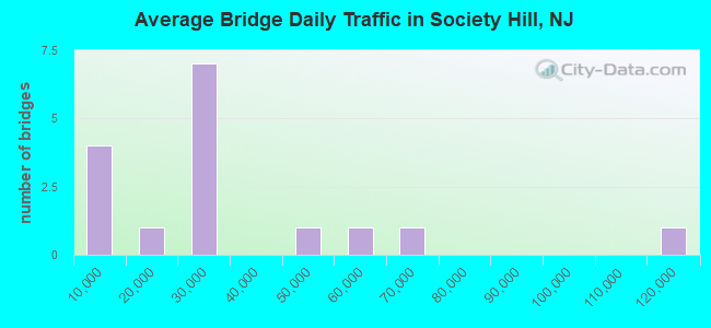
- 482,011Total average daily traffic
- 30,681Total average daily truck traffic
- National Bridge Inventory (NBI) Registered Bridges for Society Hill
- No street view available for this location
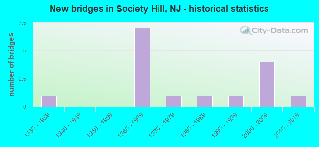
- New bridges - historical statistics
- 11930-1939
- 71960-1969
- 11970-1979
- 11980-1989
- 11990-1999
- 42000-2009
- 12010-2019
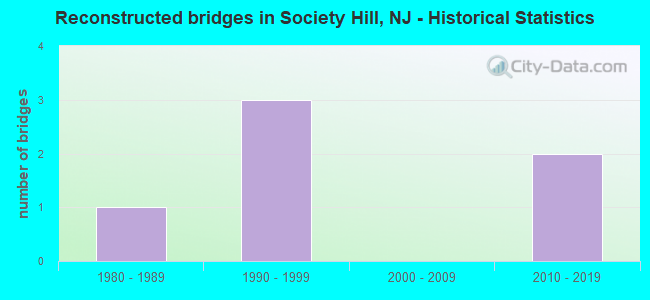
- Reconstructed bridges - Historical Statistics
- 11980-1989
- 31990-1999
- 02000-2009
- 22010-2019
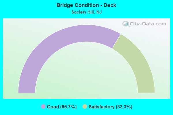
- Bridge Condition - Deck
- 66.7%Good
- 33.3%Satisfactory
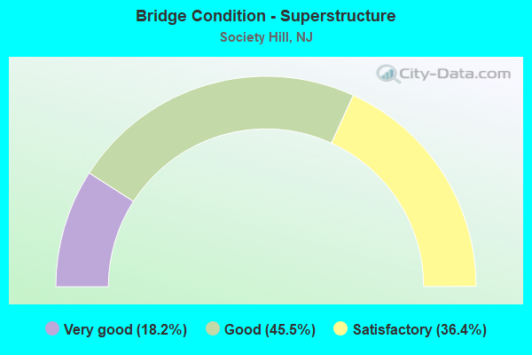
- Bridge Condition - Superstructure
- 18.2%Very good
- 45.5%Good
- 36.4%Satisfactory
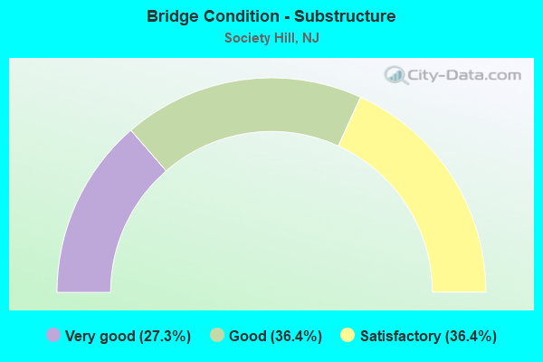
- Bridge Condition - Substructure
- 27.3%Very good
- 36.4%Good
- 36.4%Satisfactory
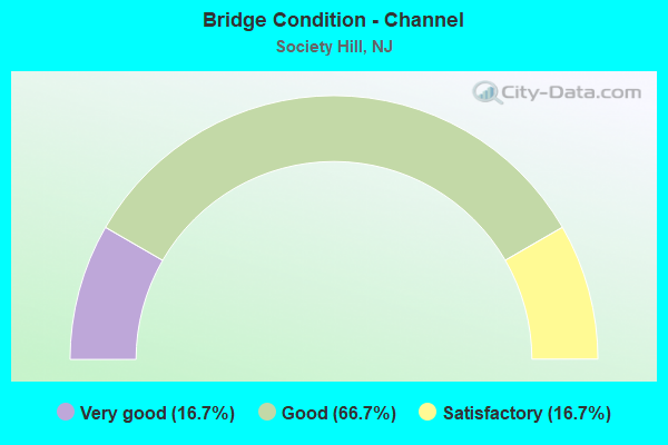
- Bridge Condition - Channel
- 16.7%Very good
- 66.7%Good
- 16.7%Satisfactory
Find on map >> Show street view
Structure Number: 122B127, Location: 0.15 miles south of CR665 (Lat: 40.540619, Lng: -74.438381), Route carried "on" structure: County highway 609, Year Built: 1979, Status: Open, Structure Length: 1.40m (4.59ft), Average Daily Traffic: 26,338 (year 2021), Truck Traffic: 4%, Average Future Daily Traffic: 32,138 (year 2041), Design Load: H 20, Features Intersected: LAKE NELSON
Minimum Vertical Clearance: 30+ m (98+ ft), Kilometerpoint: 5.295, Lanes on structure: 2, Base Highway Network: Yes, Owner: County Highway Agency, Approaching Roadway Width: 9.8m (32.2ft), Material/Design: Prestressed concrete, Design/Construction: Box Beam or Girders - Single/Spread, Number Of Spans In Main Unit: 1, Length of Maximum Span: 12.8m (42.0ft), Curb or Sidewalk Widths: Left: 1.5m (4.9ft), Right: 1.5m (4.9ft), Curb-To-Curb Width: 9.8m (32.2ft), Out-to-Out Width: 13.5m (44.3ft)
Condition: Deck: Good, Superstructure: Good, Substructure: Good, Channel: Very good, Operating Rating: 80.7 metric tons, Method Used To Determine Operating Rating: Load Factor (LF), Inventory Rating: 42.6 metric tons, Method Used To Determine Inventory Rating: Load Factor (LF), Structural Evaluation: Better than present minimum criteria, Deck Geometry: Meets minimum limits, Waterway Adequacy: Superior to present desirable criteria, Approach Roadway Alignment: Equal to present minimum criteria, Designated Inspection Frequency: Every 24 months, Inspection Date: May 2021, Deck Structure Type: Concrete Cast-file-Place, Wearing Surface/Protective System: Wearing Surface: Low Slump Concrete
Find on map >> Show street view
Structure Number: 122B129, Location: 0.5 MI. N. OF METLARS LA (Lat: 40.539469, Lng: -74.452969), Route carried "on" structure: City street , Year Built: 1938, Year Reconstructed: 2002, Status: Open, Structure Length: 1.07m (3.51ft), Average Daily Traffic: 26,023 (year 2021), Truck Traffic: 3%, Average Future Daily Traffic: 31,753 (year 2041), Features Intersected: AMBROSE BROOK, Facility Carried by Structure: S.RANDOLPHVILLE RD
Minimum Vertical Clearance: 30+ m (98+ ft), Kilometerpoint: 0.805, Lanes on structure: 2, Owner: County Highway Agency, Approaching Roadway Width: 7.9m (25.9ft), Material/Design: Steel, Design/Construction: Arch - Deck, Number Of Spans In Main Unit: 2, Length of Maximum Span: 4.9m (16.1ft), Curb-To-Curb Width: 8.0m (26.2ft), Out-to-Out Width: 9.4m (30.8ft)
Condition: Superstructure: Satisfactory, Substructure: Satisfactory, Channel: Satisfactory, Operating Rating: 45.4 metric tons, Method Used To Determine Operating Rating: Load Factor (LF), Inventory Rating: 38.1 metric tons, Method Used To Determine Inventory Rating: Load Factor (LF), Structural Evaluation: Equal to present minimum criteria, Deck Geometry: High priority of replacement, Waterway Adequacy: Superior to present desirable criteria, Approach Roadway Alignment: Better than present minimum criteria, Length Of Structure Improvement: 1.07m (3.51ft), Designated Inspection Frequency: Every 24 months, Inspection Date: May 2021, Bridge Improvement Cost: $92,000, Roadway Improvement Cost: $79,000, Total Project Cost: $436,000 ( Estimate for 2021)
Find on map >> Show street view
Structure Number: 122B133, Location: 0.67 miles east of SR 18 (Lat: 40.547231, Lng: -74.464239), Route carried "on" structure: City street , Year Built: 2011, Status: Open, Structure Length: 0.61m (2.00ft), Average Daily Traffic: 7,917 (year 2021), Truck Traffic: 1%, Average Future Daily Traffic: 9,501 (year 2041), Design Load: HS 25 or greater, Features Intersected: AMBROSE BROOK, Facility Carried by Structure: SIDNEY ROAD
Minimum Vertical Clearance: 30+ m (98+ ft), Kilometerpoint: 0.161, Lanes on structure: 2, Owner: County Highway Agency, Approaching Roadway Width: 9.8m (32.2ft), Material/Design: Concrete, Design/Construction: Frame, Number Of Spans In Main Unit: 1, Length of Maximum Span: 6.1m (20.0ft), Curb or Sidewalk Widths: Left: 0.2m (0.7ft), Right: 1.5m (4.9ft), Curb-To-Curb Width: 9.8m (32.2ft), Out-to-Out Width: 12.8m (42.0ft)
Condition: Deck: Good, Superstructure: Good, Substructure: Very good, Channel: Good, Inventory Rating: 85.3 metric tons, Method Used To Determine Inventory Rating: Load Factor (LF), Structural Evaluation: Better than present minimum criteria, Deck Geometry: Meets minimum limits, Waterway Adequacy: Better than present minimum criteria, Approach Roadway Alignment: Better than present minimum criteria, Designated Inspection Frequency: Every 24 months, Inspection Date: November 2021, Deck Structure Type: Other, Wearing Surface/Protective System: Wearing Surface: Bituminous, Deck Protection: Epoxy Coated Reinforcing
Find on map >> Show street view
Structure Number: 122B174, Location: 0.6MI. SOUTH OF RT.287 (Lat: 40.548561, Lng: -74.475719), Route carried "on" structure: State highway 18, Year Built: 1980, Year Reconstructed: 2015, Status: Open, Structure Length: 1.62m (5.31ft), Average Daily Traffic: 23,577 (year 2021), Truck Traffic: 4%, Average Future Daily Traffic: 28,769 (year 2041), Features Intersected: AMBROSE BROOK
Minimum Vertical Clearance: 30+ m (98+ ft), Kilometerpoint: 76.122, Lanes on structure: 5, Base Highway Network: Yes, Owner: State Highway Agency, Approaching Roadway Width: 22.9m (75.1ft), Skew: 11 degrees, Material/Design: Prestressed concrete, Design/Construction: Box Beam or Girders - Multiple, Number Of Spans In Main Unit: 1, Length of Maximum Span: 14.6m (47.9ft), Curb or Sidewalk Widths: Left: 1.8m (5.9ft), Right: 1.2m (3.9ft), Curb-To-Curb Width: 22.9m (75.1ft), Out-to-Out Width: 28.1m (92.2ft)
Condition: Deck: Satisfactory, Superstructure: Good, Substructure: Good, Channel: Good, Operating Rating: 62.6 metric tons, Method Used To Determine Operating Rating: Load Factor (LF), Inventory Rating: 37.2 metric tons, Method Used To Determine Inventory Rating: Load Factor (LF), Structural Evaluation: Better than present minimum criteria, Deck Geometry: Somewhat better than minimum adequacy, Waterway Adequacy: Superior to present desirable criteria, Approach Roadway Alignment: Better than present minimum criteria, Designated Inspection Frequency: Every 24 months, Inspection Date: April 2021, Deck Structure Type: Concrete Cast-file-Place, Wearing Surface/Protective System: Wearing Surface: Low Slump Concrete
Find on map >> Show street view
Structure Number: 122B24, Location: 0.25 MI. S. OF INTER. 287 (Lat: 40.551719, Lng: -74.480431), Route carried "on" structure: State highway 18, Year Built: 1966, Year Reconstructed: 2016, Status: Open, Structure Length: 1.52m (4.99ft), Average Daily Traffic: 23,789 (year 2021), Truck Traffic: 4%, Average Future Daily Traffic: 29,027 (year 2041), Design Load: HS 20, Features Intersected: AMBROSE BROOK
Minimum Vertical Clearance: 30+ m (98+ ft), Kilometerpoint: 76.766, Lanes on structure: 4, Base Highway Network: Yes, Owner: State Highway Agency, Approaching Roadway Width: 17.1m (56.1ft), Skew: 10 degrees, Material/Design: Steel, Design/Construction: Stringer/Multi-beam, Number Of Spans In Main Unit: 1, Length of Maximum Span: 14.0m (45.9ft), Curb or Sidewalk Widths: Left: 0.5m (1.6ft), Right: 1.2m (3.9ft), Curb-To-Curb Width: 17.1m (56.1ft), Out-to-Out Width: 21.9m (71.9ft)
Condition: Deck: Good, Superstructure: Very good, Substructure: Good, Channel: Good, Inventory Rating: 59.9 metric tons, Method Used To Determine Inventory Rating: Load Factor (LF), Structural Evaluation: Better than present minimum criteria, Deck Geometry: High priority of corrective action, Waterway Adequacy: Superior to present desirable criteria, Approach Roadway Alignment: Equal to present minimum criteria, Designated Inspection Frequency: Every 24 months, Inspection Date: April 2021, Deck Structure Type: Concrete Cast-file-Place, Wearing Surface/Protective System: Wearing Surface: Bituminous
Find on map >> Show street view
Structure Number: 122B501, Location: 0.2 MI.S.OF MORRIS AVENUE (Lat: 40.532731, Lng: -74.452861), Route carried "on" structure: City street , Year Built: 1990, Status: Open, Structure Length: 1.22m (4.00ft), Average Daily Traffic: 760 (year 2021), Truck Traffic: 1%, Average Future Daily Traffic: 912 (year 2041), Design Load: HS 20, Features Intersected: TRIB. TO AMBROSE BROOK, Facility Carried by Structure: BUCKINGHAM DRIVE
Minimum Vertical Clearance: 30+ m (98+ ft), Kilometerpoint: 0.000, Lanes on structure: 2, Owner: County Highway Agency, Approaching Roadway Width: 11.0m (36.1ft), Material/Design: Concrete, Design/Construction: Arch - Deck, Number Of Spans In Main Unit: 1, Length of Maximum Span: 12.2m (40.0ft), Curb or Sidewalk Widths: Left: 1.2m (3.9ft), Right: 1.2m (3.9ft), Curb-To-Curb Width: 11.1m (36.4ft), Out-to-Out Width: 18.9m (62.0ft)
Condition: Superstructure: Good, Substructure: Good, Channel: Good, Operating Rating: 89.8 metric tons, Method Used To Determine Operating Rating: Load Factor (LF), Inventory Rating: 85.3 metric tons, Method Used To Determine Inventory Rating: Load Factor (LF), Structural Evaluation: Better than present minimum criteria, Deck Geometry: Better than present minimum criteria, Waterway Adequacy: Equal to present desirable criteria, Approach Roadway Alignment: Equal to present desirable criteria, Designated Inspection Frequency: Every 24 months, Inspection Date: April 2021
Find on map >> Show street view
Structure Number: 1231162, Location: I-287 (EXIT 7) (Lat: 40.556850, Lng: -74.462131), Route carried "on" structure: Interstate 287, Year Built: 1961, Year Reconstructed: 1994, Status: Open, Structure Length: 4.51m (14.80ft), Average Daily Traffic: 62,215 (year 2020), Truck Traffic: 9%, Average Future Daily Traffic: 92,700 (year 2040), Design Load: HS 20, Features Intersected: SOUTH RANDOLPHVILLE RD
Minimum Vertical Clearance: 30+ m (98+ ft), Kilometerpoint: 11.700, Lanes on structure: 4, Lanes under structure: 5, Base Highway Network: Yes, Owner: State Highway Agency, Approaching Roadway Width: 18.9m (62.0ft), Skew: 3 degrees, Material/Design: Prestressed concrete, Design/Construction: Stringer/Multi-beam, Number Of Spans In Main Unit: 3, Length of Maximum Span: 23.5m (77.1ft), Curb or Sidewalk Widths: Left: 0.5m (1.6ft), Right: 0.0m, Curb-To-Curb Width: 18.9m (62.0ft), Out-to-Out Width: 20.4m (66.9ft)
Condition: Deck: Satisfactory, Superstructure: Satisfactory, Substructure: Satisfactory, Operating Rating: 39.9 metric tons, Method Used To Determine Operating Rating: Load Factor (LF), Inventory Rating: 23.6 metric tons, Method Used To Determine Inventory Rating: Load Factor (LF), Structural Evaluation: Somewhat better than minimum adequacy, Deck Geometry: Meets minimum limits, Underclear: High priority of replacement, Approach Roadway Alignment: Equal to present desirable criteria, Length Of Structure Improvement: 5.43m (17.81ft), Designated Inspection Frequency: Every 24 months, Inspection Date: August 2020, Bridge Improvement Cost: $4,984,000, Roadway Improvement Cost: $493,000, Total Project Cost: $7,949,000 ( Estimate for 2020), Deck Structure Type: Concrete Cast-file-Place, Wearing Surface/Protective System: Wearing Surface: Bituminous
Find on map >> Show street view
Structure Number: 1231163, Location: AT I-287 EXIT-7 (Lat: 40.556339, Lng: -74.462050), Route carried "on" structure: Interstate 287, Year Built: 1962, Year Reconstructed: 1995, Status: Open, Structure Length: 4.51m (14.80ft), Average Daily Traffic: 56,010 (year 2020), Truck Traffic: 9%, Average Future Daily Traffic: 83,455 (year 2040), Design Load: HS 25 or greater, Features Intersected: S RANDOLPHVILLE ROAD
Minimum Vertical Clearance: 30+ m (98+ ft), Kilometerpoint: 11.700, Lanes on structure: 3, Lanes under structure: 5, Base Highway Network: Yes, Owner: State Highway Agency, Approaching Roadway Width: 15.2m (49.9ft), Skew: 3 degrees, Material/Design: Prestressed concrete, Design/Construction: Stringer/Multi-beam, Number Of Spans In Main Unit: 3, Length of Maximum Span: 23.5m (77.1ft), Curb or Sidewalk Widths: Left: 0.5m (1.6ft), Right: 0.5m (1.6ft), Curb-To-Curb Width: 15.2m (49.9ft), Out-to-Out Width: 16.9m (55.4ft)
Condition: Deck: Satisfactory, Superstructure: Satisfactory, Substructure: Satisfactory, Operating Rating: 49.9 metric tons, Method Used To Determine Operating Rating: Load Factor (LF), Inventory Rating: 24.5 metric tons, Method Used To Determine Inventory Rating: Load Factor (LF), Structural Evaluation: Equal to present minimum criteria, Deck Geometry: Meets minimum limits, Underclear: High priority of corrective action, Approach Roadway Alignment: Equal to present desirable criteria, Length Of Structure Improvement: 3.05m (10.01ft), Designated Inspection Frequency: Every 24 months, Inspection Date: August 2020, Roadway Improvement Cost: $29,000, Total Project Cost: $61,000 ( Estimate for 2020), Deck Structure Type: Concrete Cast-file-Place, Wearing Surface/Protective System: Wearing Surface: Bituminous
Find on map >> Show street view
Structure Number: 1231164, Location: 1.01 MI. S. OF CR 665 (Lat: 40.556481, Lng: -74.471061), Route carried "on" structure: City street , Year Built: 1961, Year Reconstructed: 1995, Status: Open, Structure Length: 9.91m (32.51ft), Average Daily Traffic: 1,898 (year 2020), Truck Traffic: 4%, Average Future Daily Traffic: 2,316 (year 2040), Design Load: HS 20, Features Intersected: I-287, Facility Carried by Structure: OLD NEW BRUNSWICK
Minimum Vertical Clearance: 30+ m (98+ ft), Kilometerpoint: 0.901, Lanes on structure: 2, Lanes under structure: 6, Owner: State Highway Agency, Approaching Roadway Width: 9.1m (29.9ft), Skew: 4 degrees, Material/Design: Steel, Design/Construction: Stringer/Multi-beam, Number Of Spans In Main Unit: 4, Length of Maximum Span: 35.4m (116.1ft), Curb or Sidewalk Widths: Left: 1.8m (5.9ft), Right: 1.4m (4.6ft), Curb-To-Curb Width: 9.1m (29.9ft), Out-to-Out Width: 13.6m (44.6ft)
Condition: Deck: Good, Superstructure: Satisfactory, Substructure: Satisfactory, Operating Rating: 87.1 metric tons, Method Used To Determine Operating Rating: Load Factor (LF), Inventory Rating: 52.6 metric tons, Method Used To Determine Inventory Rating: Load Factor (LF), Structural Evaluation: Equal to present minimum criteria, Deck Geometry: Somewhat better than minimum adequacy, Underclear: Somewhat better than minimum adequacy, Approach Roadway Alignment: Better than present minimum criteria, Designated Inspection Frequency: Every 24 months, Inspection Date: September 2020, Deck Structure Type: Concrete Cast-file-Place, Wearing Surface/Protective System: Wearing Surface: Monolithic Concrete, Deck Protection: Epoxy Coated Reinforcing
Find on map >> Show street view
Structure Number: 1237161, Location: 0.41m N of River Rd Jctn (Lat: 40.516800, Lng: -74.454711), Route carried "on" structure: State highway 18, Year Built: 2004, Status: Open, Structure Length: 3.57m (11.71ft), Average Daily Traffic: 23,932 (year 2021), Truck Traffic: 5%, Average Future Daily Traffic: 29,202 (year 2041), Design Load: HL 93, Features Intersected: Campus Road
Minimum Vertical Clearance: 30+ m (98+ ft), Kilometerpoint: 71.262, Lanes on structure: 5, Lanes under structure: 2, Base Highway Network: Yes, Owner: State Highway Agency, Approaching Roadway Width: 33.0m (108.3ft), Skew: 30 degrees, Material/Design: Steel, Design/Construction: Stringer/Multi-beam, Number Of Spans In Main Unit: 1, Length of Maximum Span: 35.1m (115.2ft), Curb-To-Curb Width: 33.0m (108.3ft), Out-to-Out Width: 35.0m (114.8ft)
Condition: Deck: Good, Superstructure: Good, Substructure: Very good, Operating Rating: 69.0 metric tons, Method Used To Determine Operating Rating: Load and Resistance Factor Rating (LRFR) rating reported by rating factor(RF) method using HL-93 loadings, Inventory Rating: 58.0 metric tons, Method Used To Determine Inventory Rating: Load and Resistance Factor Rating (LRFR) rating reported by rating factor(RF) method using HL-93 loadings, Structural Evaluation: Better than present minimum criteria, Deck Geometry: Superior to present desirable criteria, Underclear: Better than present minimum criteria, Approach Roadway Alignment: Equal to present desirable criteria, Designated Inspection Frequency: Every 24 months, Inspection Date: January 2021, Deck Structure Type: Concrete Cast-file-Place, Wearing Surface/Protective System: Wearing Surface: Monolithic Concrete, Deck Protection: Epoxy Coated Reinforcing
Find on map >> Show street view
Structure Number: 1237162, Location: 0.71 N. of Campus Road (Lat: 40.525489, Lng: -74.452269), Route carried "on" structure: City street , Year Built: 2004, Status: Open, Structure Length: 6.77m (22.21ft), Average Daily Traffic: 10,610 (year 2018), Truck Traffic: 3%, Average Future Daily Traffic: 12,958 (year 2038), Design Load: HS 20+Mod, Features Intersected: NJ 18, Facility Carried by Structure: DAVIDSON ROAD
Minimum Vertical Clearance: 30.45m (99.90ft), Kilometerpoint: 0.225, Lanes on structure: 4, Lanes under structure: 6, Owner: State Highway Agency, Approaching Roadway Width: 24.4m (80.1ft), Skew: 3 degrees, Material/Design: Steel continuous, Design/Construction: Stringer/Multi-beam, Number Of Spans In Main Unit: 2, Length of Maximum Span: 34.1m (111.9ft), Curb or Sidewalk Widths: Left: 0.0m, Right: 5.6m (18.4ft), Curb-To-Curb Width: 17.1m (56.1ft), Out-to-Out Width: 24.4m (80.1ft)
Condition: Deck: Good, Superstructure: Very good, Substructure: Very good, Structural Evaluation: Equal to present desirable criteria, Deck Geometry: Somewhat better than minimum adequacy, Underclear: Meets minimum limits, Approach Roadway Alignment: Equal to present desirable criteria, Designated Inspection Frequency: Every 24 months, Inspection Date: September 2020, Deck Structure Type: Concrete Cast-file-Place, Wearing Surface/Protective System: Wearing Surface: Monolithic Concrete, Deck Protection: Epoxy Coated Reinforcing
Find on map >> Show street view
Structure Number: 1231162, Location: I-287 (EXIT 7) (Lat: 40.556850, Lng: -74.462131), Route carried "under" structure: City street , Year Built: 1961, Structure Length: 0. m, Average Daily Traffic: 22,865 (year 2020), Truck Traffic: 3%, Features Intersected: SOUTH RANDOLPHVILLE RD, Facility Carried by Structure: I-287 NB
Minimum Vertical Clearance: 4.88m (16.01ft), Kilometerpoint: 3.251, Lanes on structure: 4, Lanes under structure: 5, Material/Design: Prestressed concrete, Design/Construction: Stringer/Multi-beam, Length of Maximum Span: 23.5m (77.1ft)
Find on map >> Show street view
Structure Number: 1231163, Location: AT I-287 EXIT-7 (Lat: 40.556339, Lng: -74.462050), Route carried "under" structure: County highway 674, Year Built: 1962, Structure Length: 0. m, Average Daily Traffic: 28,371 (year 2020), Truck Traffic: 3%, Features Intersected: S RANDOLPHVILLE ROAD, Facility Carried by Structure: I-287 SB
Minimum Vertical Clearance: 5.31m (17.42ft), Kilometerpoint: 3.203, Lanes on structure: 3, Lanes under structure: 5, Material/Design: Prestressed concrete, Design/Construction: Stringer/Multi-beam, Length of Maximum Span: 23.5m (77.1ft)
Find on map >> Show street view
Structure Number: 1231164, Location: 1.01 MI. S. OF CR 665 (Lat: 40.556481, Lng: -74.471061), Route carried "under" structure: Interstate 287, Year Built: 1961, Structure Length: 0. m, Average Daily Traffic: 118,645 (year 2020), Truck Traffic: 9%, Features Intersected: I-287, Facility Carried by Structure: OLD NEW BRUNSWICK
Minimum Vertical Clearance: 5.08m (16.67ft), Kilometerpoint: 12.408, Lanes on structure: 2, Lanes under structure: 6, Material/Design: Steel, Design/Construction: Stringer/Multi-beam, Length of Maximum Span: 35.4m (116.1ft)
Find on map >> Show street view
Structure Number: 1237161, Location: 0.41m N of River Rd Jctn (Lat: 40.516800, Lng: -74.454711), Route carried "under" structure: Ramp Other road , Year Built: 2004, Structure Length: 0. m, Average Daily Traffic: 1,316 (year 2021), Truck Traffic: 3%, Features Intersected: Campus Road, Facility Carried by Structure: NJ 18
Minimum Vertical Clearance: 5.00m (16.40ft), Kilometerpoint: 0.000, Lanes on structure: 5, Lanes under structure: 2, Material/Design: Steel, Design/Construction: Stringer/Multi-beam, Length of Maximum Span: 35.1m (115.2ft)
Find on map >> Show street view
Structure Number: 1237162, Location: 0.71 N. of Campus Road (Lat: 40.525489, Lng: -74.452269), Route carried "under" structure: State highway 18, Year Built: 2004, Structure Length: 0. m, Average Daily Traffic: 47,745 (year 2018), Truck Traffic: 5%, Features Intersected: NJ 18, Facility Carried by Structure: DAVIDSON ROAD
Minimum Vertical Clearance: 5.67m (18.60ft), Kilometerpoint: 72.404, Lanes on structure: 4, Lanes under structure: 6, Material/Design: Steel continuous, Design/Construction: Stringer/Multi-beam, Length of Maximum Span: 34.1m (111.9ft)