Bridge Statistics for South Charleston, West Virginia (WV)
Condition, Traffic, Stress, Structural Evaluation, Project Costs
- National Bridge Inventory (NBI) Statistics
- 34Number of bridges
- 604ft / 184mTotal length
- $19,400,000Total costs
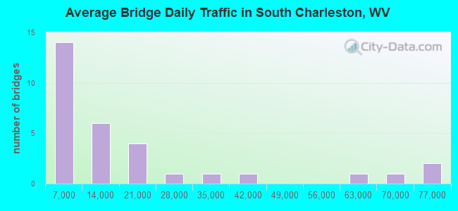
- 515,705Total average daily traffic
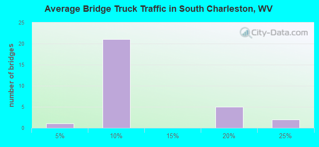
- 67,947Total average daily truck traffic
- National Bridge Inventory (NBI) Registered Bridges for South Charleston
- No street view available for this location
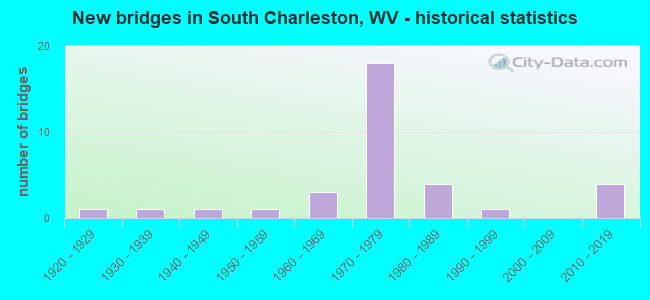
- New bridges - historical statistics
- 11920-1929
- 11930-1939
- 11940-1949
- 11950-1959
- 31960-1969
- 181970-1979
- 41980-1989
- 11990-1999
- 42010-2019
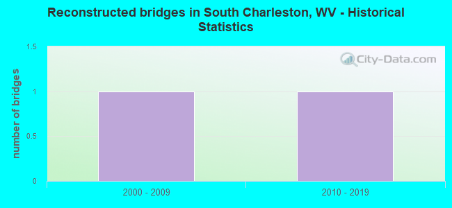
- Reconstructed bridges - Historical Statistics
- 12000-2009
- 12010-2019
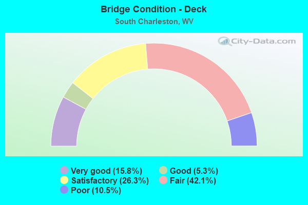
- Bridge Condition - Deck
- 15.8%Very good
- 5.3%Good
- 26.3%Satisfactory
- 42.1%Fair
- 10.5%Poor
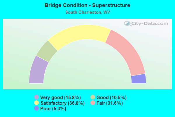
- Bridge Condition - Superstructure
- 15.8%Very good
- 10.5%Good
- 36.8%Satisfactory
- 31.6%Fair
- 5.3%Poor
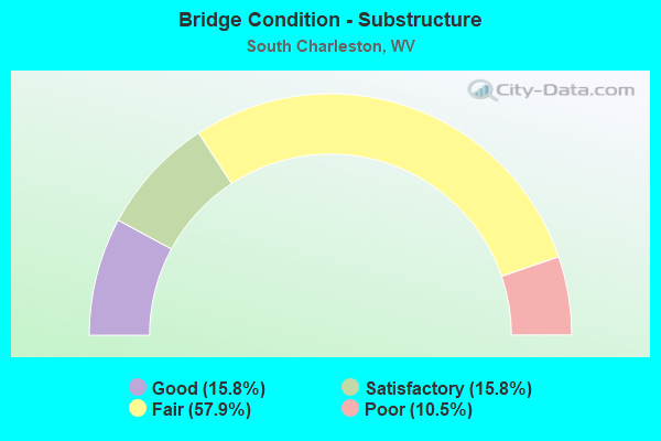
- Bridge Condition - Substructure
- 15.8%Good
- 15.8%Satisfactory
- 57.9%Fair
- 10.5%Poor
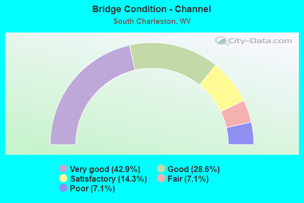
- Bridge Condition - Channel
- 42.9%Very good
- 28.6%Good
- 14.3%Satisfactory
- 7.1%Fair
- 7.1%Poor
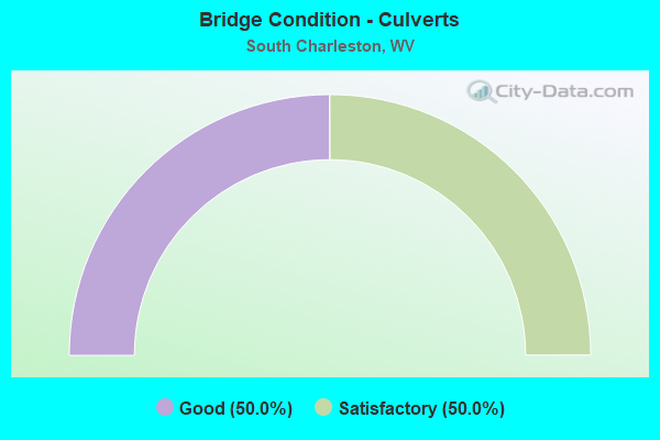
- Bridge Condition - Culverts
- 50.0%Good
- 50.0%Satisfactory
Find on map >> Show street view
Structure Number: 20A29, Location: 0.03 MI S OF CR 11 (Lat: 38.309550, Lng: -81.728019), Route carried "on" structure: State highway 214, Year Built: 1932, Status: Open, Structure Length: 0.88m (2.89ft), Average Daily Traffic: 750 (year 2018), Truck Traffic: 5%, Average Future Daily Traffic: 915 (year 2038), Features Intersected: TRACE FK OF DAVIS CREEK
Minimum Vertical Clearance: 30+ m (98+ ft), Kilometerpoint: 8.610, Lanes on structure: 2, Owner: State Highway Agency, Approaching Roadway Width: 6.1m (20.0ft), Skew: 2 degrees, Material/Design: Concrete, Design/Construction: Slab, Number Of Spans In Main Unit: 1, Length of Maximum Span: 8.4m (27.6ft), Curb or Sidewalk Widths: Left: 0.0m, Right: 0.1m (0.3ft), Curb-To-Curb Width: 10.3m (33.8ft), Out-to-Out Width: 11.1m (36.4ft)
Condition: Deck: Satisfactory, Superstructure: Satisfactory, Substructure: Fair, Channel: Poor, Operating Rating: 63.5 metric tons, Method Used To Determine Operating Rating: Field evaluation and documented engineering judgment, Inventory Rating: 29.0 metric tons, Method Used To Determine Inventory Rating: Field evaluation and documented engineering judgment, Structural Evaluation: Somewhat better than minimum adequacy, Deck Geometry: Equal to present minimum criteria, Waterway Adequacy: Somewhat better than minimum adequacy, Approach Roadway Alignment: Equal to present minimum criteria, Designated Inspection Frequency: Every 24 months, Inspection Date: September 2020, Deck Structure Type: Concrete Cast-file-Place, Wearing Surface/Protective System: Wearing Surface: Bituminous
Find on map >> Show street view
Structure Number: 20A337, Location: 0.10 MI N OF JCT US 60 (Lat: 38.355431, Lng: -81.736761), Route carried "on" structure: County highway 2547, Year Built: 1953, Status: Posted for load, Structure Length: 42.22m (138.52ft), Average Daily Traffic: 18,959 (year 2015), Truck Traffic: 6%, Average Future Daily Traffic: 23,001 (year 2035), Design Load: HS 20, Features Intersected: 10TH st.,US Rt 60, Kan R, Facility Carried by Structure: CR 25/47
Minimum Vertical Clearance: 4.55m (14.93ft), Kilometerpoint: 0.161, Lanes on structure: 2, Lanes under structure: 5, Owner: State Highway Agency, Approaching Roadway Width: 8.5m (27.9ft), Navigation Control: Yes ( Vertical Clearance: 19.8m (65.0ft), Horizontal Clearance: 121.9m (399.9ft)), Material/Design: Steel continuous, Design/Construction: Truss - Thru, Number Of Spans In Main Unit: 1, Number Of Approach Spans: 8, Length of Maximum Span: 193.2m (633.9ft), Curb or Sidewalk Widths: Left: 0.5m (1.6ft), Right: 1.4m (4.6ft), Curb-To-Curb Width: 8.5m (27.9ft), Out-to-Out Width: 10.6m (34.8ft)
Condition: Deck: Fair, Superstructure: Poor, Substructure: Poor, Channel: Good, Operating Rating: 53.5 metric tons, Method Used To Determine Operating Rating: Load Factor (LF), Inventory Rating: 31.7 metric tons, Method Used To Determine Inventory Rating: Load Factor (LF), Structural Evaluation: Meets minimum limits, Deck Geometry: Meets minimum limits, Underclear: Meets minimum limits, Waterway Adequacy: Equal to present desirable criteria, Approach Roadway Alignment: Meets minimum limits, Length Of Structure Improvement: 42.18m (138.39ft), Designated Inspection Frequency: Every 24 months, Critical Feature Inspection Frequency: Every 12 months, Underwater Inspection Frequency: Every 60 months, Other Special Inspection Frequency: Every 12 months, Inspection Date: April 2021, Critical Feature Inspection Date: April 2021, Underwater Inspection Date: August 2019, Other Special Inspection Date: April 2021, Bridge Improvement Cost: $11,850,000, Roadway Improvement Cost: $150,000, Total Project Cost: $12,000,000, Deck Structure Type: Concrete Cast-file-Place, Wearing Surface/Protective System: Wearing Surface: Latex Concrete
Find on map >> Show street view
Structure Number: 20A338, Location: 0.12 MI E OF US 60 (Lat: 38.358061, Lng: -81.715639), Route carried "on" structure: Ramp Interstate 64, Year Built: 1973, Status: Open, Structure Length: 4.50m (14.76ft), Average Daily Traffic: 12,418 (year 2017), Truck Traffic: 21%, Average Future Daily Traffic: 19,372 (year 2037), Design Load: HS 20+Mod, Features Intersected: JEFFERSON RD
Minimum Vertical Clearance: 30+ m (98+ ft), Kilometerpoint: 86.583, Lanes on structure: 2, Lanes under structure: 3, Owner: State Highway Agency, Approaching Roadway Width: 15.9m (52.2ft), Skew: 29 degrees, Material/Design: Steel continuous, Design/Construction: Stringer/Multi-beam, Number Of Spans In Main Unit: 1, Number Of Approach Spans: 2, Length of Maximum Span: 18.1m (59.4ft), Curb-To-Curb Width: 17.3m (56.8ft), Out-to-Out Width: 18.4m (60.4ft)
Condition: Deck: Fair, Superstructure: Fair, Substructure: Fair, Operating Rating: 64.4 metric tons, Method Used To Determine Operating Rating: Load Factor (LF), Inventory Rating: 38.1 metric tons, Method Used To Determine Inventory Rating: Load Factor (LF), Structural Evaluation: Somewhat better than minimum adequacy, Deck Geometry: Superior to present desirable criteria, Underclear: High priority of corrective action, Approach Roadway Alignment: Equal to present minimum criteria, Length Of Structure Improvement: 4.50m (14.76ft), Designated Inspection Frequency: Every 24 months, Inspection Date: July 2021, Bridge Improvement Cost: $550,000, Roadway Improvement Cost: $100,000, Total Project Cost: $650,000 ( Estimate for 2019), Deck Structure Type: Concrete Cast-file-Place, Wearing Surface/Protective System: Wearing Surface: Latex Concrete
Find on map >> Show street view
Structure Number: 20A339, Location: 0.14 MI E OF WV 601 (Lat: 38.361131, Lng: -81.715281), Route carried "on" structure: US 60, Year Built: 1973, Status: Open, Structure Length: 6.90m (22.64ft), Average Daily Traffic: 13,600 (year 2018), Truck Traffic: 5%, Average Future Daily Traffic: 16,592 (year 2038), Design Load: HS 20+Mod, Features Intersected: DAVIS CREEK
Minimum Vertical Clearance: 30+ m (98+ ft), Kilometerpoint: 18.202, Lanes on structure: 6, Base Highway Network: Yes, Owner: State Highway Agency, Approaching Roadway Width: 28.0m (91.9ft), Skew: 20 degrees, Material/Design: Steel continuous, Design/Construction: Stringer/Multi-beam, Number Of Spans In Main Unit: 1, Number Of Approach Spans: 2, Length of Maximum Span: 25.9m (85.0ft), Curb-To-Curb Width: 27.6m (90.6ft), Out-to-Out Width: 28.7m (94.2ft)
Condition: Deck: Fair, Superstructure: Good, Substructure: Fair, Channel: Very good, Operating Rating: 74.4 metric tons, Method Used To Determine Operating Rating: Load Factor (LF), Inventory Rating: 44.4 metric tons, Method Used To Determine Inventory Rating: Load Factor (LF), Structural Evaluation: Somewhat better than minimum adequacy, Deck Geometry: Better than present minimum criteria, Waterway Adequacy: Equal to present desirable criteria, Approach Roadway Alignment: Equal to present desirable criteria, Length Of Structure Improvement: 6.90m (22.64ft), Designated Inspection Frequency: Every 24 months, Inspection Date: October 2020, Bridge Improvement Cost: $750,000, Roadway Improvement Cost: $100,000, Total Project Cost: $850,000 ( Estimate for 2020), Deck Structure Type: Concrete Cast-file-Place, Wearing Surface/Protective System: Wearing Surface: Latex Concrete
Find on map >> Show street view
Structure Number: 20A365, Location: 0.15 MI S OF US 60 (Lat: 38.366661, Lng: -81.687111), Route carried "on" structure: County highway 6064, Year Built: 1974, Status: Open, Structure Length: 4.56m (14.96ft), Average Daily Traffic: 15,600 (year 2020), Truck Traffic: 6%, Average Future Daily Traffic: 20,436 (year 2040), Design Load: HS 20+Mod, Features Intersected: SECOND AVENUE, Facility Carried by Structure: CR 60/64
Minimum Vertical Clearance: 30+ m (98+ ft), Kilometerpoint: 0.241, Lanes on structure: 6, Lanes under structure: 2, Owner: State Highway Agency, Approaching Roadway Width: 25.0m (82.0ft), Skew: 22 degrees, Material/Design: Steel continuous, Design/Construction: Stringer/Multi-beam, Number Of Spans In Main Unit: 1, Number Of Approach Spans: 2, Length of Maximum Span: 18.3m (60.0ft), Curb or Sidewalk Widths: Left: 1.5m (4.9ft), Right: 0.0m, Curb-To-Curb Width: 26.3m (86.3ft), Out-to-Out Width: 28.7m (94.2ft)
Condition: Deck: Fair, Superstructure: Satisfactory, Substructure: Fair, Operating Rating: 62.6 metric tons, Method Used To Determine Operating Rating: Load Factor (LF), Inventory Rating: 37.2 metric tons, Method Used To Determine Inventory Rating: Load Factor (LF), Structural Evaluation: Somewhat better than minimum adequacy, Deck Geometry: Equal to present minimum criteria, Underclear: Meets minimum limits, Approach Roadway Alignment: Equal to present desirable criteria, Length Of Structure Improvement: 4.56m (14.96ft), Designated Inspection Frequency: Every 24 months, Inspection Date: October 2021, Bridge Improvement Cost: $750,000, Roadway Improvement Cost: $50,000, Total Project Cost: $800,000 ( Estimate for 2019), Deck Structure Type: Concrete Cast-file-Place, Wearing Surface/Protective System: Wearing Surface: Integral Concrete
Find on map >> Show street view
Structure Number: 20A367, Location: 0.20 MI S OF US 60 (Lat: 38.365619, Lng: -81.687181), Route carried "on" structure: County highway 6064, Year Built: 1974, Status: Open, Structure Length: 4.33m (14.21ft), Average Daily Traffic: 15,600 (year 2020), Truck Traffic: 5%, Average Future Daily Traffic: 20,436 (year 2040), Design Load: HS 20+Mod, Features Intersected: CR 60/64, Facility Carried by Structure: CR 60/64
Minimum Vertical Clearance: 30+ m (98+ ft), Kilometerpoint: 0.322, Lanes on structure: 6, Lanes under structure: 2, Owner: State Highway Agency, Approaching Roadway Width: 24.7m (81.0ft), Skew: 20 degrees, Material/Design: Steel continuous, Design/Construction: Stringer/Multi-beam, Number Of Spans In Main Unit: 1, Number Of Approach Spans: 1, Length of Maximum Span: 24.8m (81.4ft), Curb or Sidewalk Widths: Left: 1.5m (4.9ft), Right: 0.0m, Curb-To-Curb Width: 25.8m (84.6ft), Out-to-Out Width: 28.3m (92.8ft)
Condition: Deck: Poor, Superstructure: Satisfactory, Substructure: Fair, Operating Rating: 54.4 metric tons, Method Used To Determine Operating Rating: Load Factor (LF), Inventory Rating: 32.7 metric tons, Method Used To Determine Inventory Rating: Load Factor (LF), Structural Evaluation: Somewhat better than minimum adequacy, Deck Geometry: Somewhat better than minimum adequacy, Underclear: Somewhat better than minimum adequacy, Approach Roadway Alignment: Equal to present desirable criteria, Length Of Structure Improvement: 4.33m (14.21ft), Designated Inspection Frequency: Every 24 months, Inspection Date: December 2021, Bridge Improvement Cost: $950,000, Roadway Improvement Cost: $50,000, Total Project Cost: $1,000,000 ( Estimate for 2019), Deck Structure Type: Concrete Cast-file-Place, Wearing Surface/Protective System: Wearing Surface: Integral Concrete
Find on map >> Show street view
Structure Number: 20A369, Location: 0.25 MI S OF US 60 (Lat: 38.364650, Lng: -81.686761), Route carried "on" structure: County highway 6064, Year Built: 1974, Status: Open, Structure Length: 5.67m (18.60ft), Average Daily Traffic: 9,800 (year 2018), Truck Traffic: 20%, Average Future Daily Traffic: 11,956 (year 2038), Design Load: HS 20+Mod, Features Intersected: I-64 EB & WB, Facility Carried by Structure: CR 60/64
Minimum Vertical Clearance: 30+ m (98+ ft), Kilometerpoint: 0.402, Lanes on structure: 5, Lanes under structure: 6, Owner: State Highway Agency, Approaching Roadway Width: 20.1m (65.9ft), Skew: 20 degrees, Material/Design: Steel continuous, Design/Construction: Stringer/Multi-beam, Number Of Spans In Main Unit: 2, Length of Maximum Span: 27.4m (89.9ft), Curb or Sidewalk Widths: Left: 0.0m, Right: 1.5m (4.9ft), Curb-To-Curb Width: 22.2m (72.8ft), Out-to-Out Width: 24.6m (80.7ft)
Condition: Deck: Fair, Superstructure: Fair, Substructure: Fair, Operating Rating: 58.0 metric tons, Method Used To Determine Operating Rating: Load Factor (LF), Inventory Rating: 34.5 metric tons, Method Used To Determine Inventory Rating: Load Factor (LF), Structural Evaluation: Somewhat better than minimum adequacy, Deck Geometry: Equal to present minimum criteria, Underclear: Somewhat better than minimum adequacy, Approach Roadway Alignment: Equal to present desirable criteria, Length Of Structure Improvement: 5.67m (18.60ft), Designated Inspection Frequency: Every 24 months, Other Special Inspection Frequency: Every 24 months, Inspection Date: August 2020, Other Special Inspection Date: August 2020, Bridge Improvement Cost: $850,000, Roadway Improvement Cost: $100,000, Total Project Cost: $950,000 ( Estimate for 2020), Deck Structure Type: Concrete Cast-file-Place, Wearing Surface/Protective System: Wearing Surface: Integral Concrete
Find on map >> Show street view
Structure Number: 20A373, Location: 0.03 MI W OF CR 61/12 (Lat: 38.360481, Lng: -81.697739), Route carried "on" structure: Ramp County highway 6113, Year Built: 1973, Status: Open, Structure Length: 6.74m (22.11ft), Average Daily Traffic: 4,900 (year 2020), Truck Traffic: 5%, Average Future Daily Traffic: 6,419 (year 2040), Design Load: HS 20+Mod, Features Intersected: I-64 EB & WB, Facility Carried by Structure: COUNTY ROUTE 61/13
Minimum Vertical Clearance: 30+ m (98+ ft), Kilometerpoint: 0.048, Lanes on structure: 1, Lanes under structure: 6, Owner: State Highway Agency, Approaching Roadway Width: 13.7m (44.9ft), Skew: 4 degrees, Material/Design: Steel continuous, Design/Construction: Stringer/Multi-beam, Number Of Spans In Main Unit: 1, Number Of Approach Spans: 1, Length of Maximum Span: 38.1m (125.0ft), Curb-To-Curb Width: 8.0m (26.2ft), Out-to-Out Width: 9.2m (30.2ft)
Condition: Deck: Poor, Superstructure: Fair, Substructure: Fair, Operating Rating: 54.4 metric tons, Method Used To Determine Operating Rating: Load Factor (LF), Inventory Rating: 32.7 metric tons, Method Used To Determine Inventory Rating: Load Factor (LF), Structural Evaluation: Somewhat better than minimum adequacy, Deck Geometry: Superior to present desirable criteria, Underclear: Meets minimum limits, Approach Roadway Alignment: Meets minimum limits, Length Of Structure Improvement: 6.74m (22.11ft), Designated Inspection Frequency: Every 24 months, Inspection Date: December 2021, Bridge Improvement Cost: $750,000, Roadway Improvement Cost: $75,000, Total Project Cost: $825,000 ( Estimate for 2019), Deck Structure Type: Concrete Cast-file-Place, Wearing Surface/Protective System: Wearing Surface: Integral Concrete
Find on map >> Show street view
Structure Number: 20A387, Location: 0.85 MI E OF CR 25/25 (Lat: 38.361969, Lng: -81.718461), Route carried "on" structure: Interstate 64, Year Built: 1974, Year Reconstructed: 2011, Status: Open, Structure Length: 72.63m (238.29ft), Average Daily Traffic: 36,490 (year 2018), Truck Traffic: 18%, Average Future Daily Traffic: 63,858 (year 2038), Design Load: HS 20+Mod, Features Intersected: US60,WV25,KAN RV,N&S RR
Minimum Vertical Clearance: 30+ m (98+ ft), Kilometerpoint: 85.730, Lanes on structure: 4, Lanes under structure: 10, Base Highway Network: Yes, Owner: State Highway Agency, Approaching Roadway Width: 24.4m (80.1ft), Skew: 9 degrees, Navigation Control: Yes ( Vertical Clearance: 19.5m (64.0ft), Horizontal Clearance: 121.9m (399.9ft)), Material/Design: Steel continuous, Design/Construction: Girder and Floorbeam System, Number Of Spans In Main Unit: 3, Number Of Approach Spans: 11, Length of Maximum Span: 128.0m (419.9ft), Curb-To-Curb Width: 22.6m (74.1ft), Out-to-Out Width: 23.9m (78.4ft)
Condition: Deck: Good, Superstructure: Fair, Substructure: Satisfactory, Channel: Good, Operating Rating: 49.0 metric tons, Method Used To Determine Operating Rating: Load Factor (LF), Inventory Rating: 32.7 metric tons, Method Used To Determine Inventory Rating: Load Factor (LF), Structural Evaluation: Somewhat better than minimum adequacy, Deck Geometry: Superior to present desirable criteria, Underclear: High priority of corrective action, Waterway Adequacy: Superior to present desirable criteria, Approach Roadway Alignment: Equal to present desirable criteria, Designated Inspection Frequency: Every 24 months, Critical Feature Inspection Frequency: Every 12 months, Underwater Inspection Frequency: Every 60 months, Other Special Inspection Frequency: Every 12 months, Inspection Date: September 2021, Critical Feature Inspection Date: September 2021, Underwater Inspection Date: December 2018, Other Special Inspection Date: September 2021, Deck Structure Type: Concrete Cast-file-Place, Wearing Surface/Protective System: Wearing Surface: Integral Concrete
Find on map >> Show street view
Structure Number: 20A389, Location: 1.53 MI E OF CR 25/25 (Lat: 38.360000, Lng: -81.711700), Route carried "on" structure: Interstate 64, Year Built: 1973, Status: Open, Structure Length: 8.84m (29.00ft), Average Daily Traffic: 63,100 (year 2020), Truck Traffic: 17%, Average Future Daily Traffic: 98,436 (year 2040), Design Load: HS 25 or greater, Features Intersected: DAVIS CREEK
Minimum Vertical Clearance: 30+ m (98+ ft), Kilometerpoint: 86.792, Lanes on structure: 5, Base Highway Network: Yes, Owner: State Highway Agency, Approaching Roadway Width: 31.4m (103.0ft), Skew: 33 degrees, Material/Design: Steel continuous, Design/Construction: Stringer/Multi-beam, Number Of Spans In Main Unit: 1, Number Of Approach Spans: 2, Length of Maximum Span: 35.4m (116.1ft), Curb-To-Curb Width: 30.4m (99.7ft), Out-to-Out Width: 32.2m (105.6ft)
Condition: Deck: Satisfactory, Superstructure: Fair, Substructure: Fair, Channel: Very good, Operating Rating: 75.3 metric tons, Method Used To Determine Operating Rating: Load Factor (LF), Inventory Rating: 45.4 metric tons, Method Used To Determine Inventory Rating: Load Factor (LF), Structural Evaluation: Somewhat better than minimum adequacy, Deck Geometry: Superior to present desirable criteria, Waterway Adequacy: Equal to present minimum criteria, Approach Roadway Alignment: Equal to present desirable criteria, Designated Inspection Frequency: Every 24 months, Other Special Inspection Frequency: Every 12 months, Inspection Date: March 2020, Other Special Inspection Date: July 2021, Deck Structure Type: Concrete Cast-file-Place, Wearing Surface/Protective System: Wearing Surface: Integral Concrete
Find on map >> Show street view
Structure Number: 20A393, Location: 1.49 MI E OF US 60 (Lat: 38.363469, Lng: -81.691439), Route carried "on" structure: Interstate 64, Year Built: 1973, Status: Open, Structure Length: 5.72m (18.77ft), Average Daily Traffic: 62,800 (year 2020), Truck Traffic: 17%, Average Future Daily Traffic: 97,968 (year 2040), Design Load: HS 20+Mod, Features Intersected: CENTRAL AVENUE
Minimum Vertical Clearance: 30+ m (98+ ft), Kilometerpoint: 88.788, Lanes on structure: 6, Lanes under structure: 2, Base Highway Network: Yes, Owner: State Highway Agency, Approaching Roadway Width: 34.1m (111.9ft), Skew: 31 degrees, Material/Design: Steel continuous, Design/Construction: Stringer/Multi-beam, Number Of Spans In Main Unit: 1, Number Of Approach Spans: 2, Length of Maximum Span: 21.3m (69.9ft), Curb-To-Curb Width: 34.2m (112.2ft), Out-to-Out Width: 36.2m (118.8ft)
Condition: Deck: Fair, Superstructure: Satisfactory, Substructure: Fair, Operating Rating: 71.7 metric tons, Method Used To Determine Operating Rating: Load Factor (LF), Inventory Rating: 42.6 metric tons, Method Used To Determine Inventory Rating: Load Factor (LF), Structural Evaluation: Somewhat better than minimum adequacy, Deck Geometry: Superior to present desirable criteria, Underclear: Meets minimum limits, Approach Roadway Alignment: Equal to present desirable criteria, Length Of Structure Improvement: 5.72m (18.77ft), Designated Inspection Frequency: Every 24 months, Inspection Date: September 2021, Bridge Improvement Cost: $950,000, Roadway Improvement Cost: $50,000, Total Project Cost: $1,000,000 ( Estimate for 2019), Deck Structure Type: Concrete Cast-file-Place, Wearing Surface/Protective System: Wearing Surface: Latex Concrete
Find on map >> Show street view
Structure Number: 20A566, Location: 0.01 MI N OF CR 61/12 (Lat: 38.354761, Lng: -81.712461), Route carried "on" structure: State highway 601, Year Built: 1983, Status: Open, Structure Length: 4.82m (15.81ft), Average Daily Traffic: 8,100 (year 2020), Truck Traffic: 5%, Average Future Daily Traffic: 8,667 (year 2040), Design Load: HS 20+Mod, Features Intersected: DAVIS CREEK
Minimum Vertical Clearance: 30+ m (98+ ft), Kilometerpoint: 2.140, Lanes on structure: 2, Owner: State Highway Agency, Approaching Roadway Width: 7.9m (25.9ft), Skew: 1 degrees, Material/Design: Steel continuous, Design/Construction: Stringer/Multi-beam, Number Of Spans In Main Unit: 1, Number Of Approach Spans: 1, Length of Maximum Span: 23.4m (76.8ft), Curb or Sidewalk Widths: Left: 0.0m, Right: 1.5m (4.9ft), Curb-To-Curb Width: 8.8m (28.9ft), Out-to-Out Width: 10.9m (35.8ft)
Condition: Deck: Satisfactory, Superstructure: Satisfactory, Substructure: Satisfactory, Channel: Very good, Operating Rating: 88.9 metric tons, Method Used To Determine Operating Rating: Load Factor (LF), Inventory Rating: 69.8 metric tons, Method Used To Determine Inventory Rating: Load Factor (LF), Structural Evaluation: Equal to present minimum criteria, Deck Geometry: High priority of corrective action, Waterway Adequacy: Equal to present desirable criteria, Approach Roadway Alignment: Equal to present desirable criteria, Length Of Structure Improvement: 4.82m (15.81ft), Designated Inspection Frequency: Every 24 months, Inspection Date: December 2021, Bridge Improvement Cost: $175,000, Roadway Improvement Cost: $25,000, Total Project Cost: $200,000 ( Estimate for 2019), Deck Structure Type: Concrete Cast-file-Place, Wearing Surface/Protective System: Wearing Surface: Monolithic Concrete, Deck Protection: Epoxy Coated Reinforcing
Find on map >> Show street view
Structure Number: 20A569, Location: 0.10 MI N OF CR 11 (Lat: 38.278631, Lng: -81.773031), Route carried "on" structure: US 119, Year Built: 1982, Status: Open, Structure Length: 0.78m (2.56ft), Average Daily Traffic: 12,100 (year 2020), Truck Traffic: 5%, Average Future Daily Traffic: 15,004 (year 2040), Design Load: HS 20, Features Intersected: ALUM CREEK
Minimum Vertical Clearance: 30+ m (98+ ft), Kilometerpoint: 12.666, Lanes on structure: 4, Base Highway Network: Yes, Owner: State Highway Agency, Approaching Roadway Width: 36.6m (120.1ft), Material/Design: Concrete, Design/Construction: Culvert, Number Of Spans In Main Unit: 1, Length of Maximum Span: 7.8m (25.6ft)
Condition: Channel: Satisfactory, Culverts: Good, Operating Rating: 63.5 metric tons, Method Used To Determine Operating Rating: Field evaluation and documented engineering judgment, Inventory Rating: 29.0 metric tons, Method Used To Determine Inventory Rating: Field evaluation and documented engineering judgment, Structural Evaluation: Better than present minimum criteria, Waterway Adequacy: Superior to present desirable criteria, Approach Roadway Alignment: Equal to present desirable criteria, Designated Inspection Frequency: Every 24 months, Inspection Date: December 2021
Find on map >> Show street view
Structure Number: 20A57, Location: 1.18 MI N CR 214/10 (Lat: 38.308150, Lng: -81.732361), Route carried "on" structure: US 119, Year Built: 1982, Status: Open, Structure Length: 0.76m (2.49ft), Average Daily Traffic: 19,719 (year 2017), Truck Traffic: 5%, Average Future Daily Traffic: 24,057 (year 2037), Design Load: HS 20, Features Intersected: POT BRANCH OF DAVIS CK
Minimum Vertical Clearance: 30+ m (98+ ft), Kilometerpoint: 17.815, Lanes on structure: 7, Base Highway Network: Yes, Owner: State Highway Agency, Approaching Roadway Width: 36.6m (120.1ft), Skew: 3 degrees, Material/Design: Concrete continuous, Design/Construction: Culvert, Number Of Spans In Main Unit: 2, Length of Maximum Span: 3.7m (12.1ft)
Condition: Channel: Satisfactory, Culverts: Satisfactory, Operating Rating: 63.5 metric tons, Method Used To Determine Operating Rating: Field evaluation and documented engineering judgment, Inventory Rating: 29.0 metric tons, Method Used To Determine Inventory Rating: Field evaluation and documented engineering judgment, Structural Evaluation: Equal to present minimum criteria, Waterway Adequacy: Superior to present desirable criteria, Approach Roadway Alignment: Equal to present desirable criteria, Designated Inspection Frequency: Every 24 months, Inspection Date: September 2021
Find on map >> Show street view
Structure Number: 20A727, Location: 0.80 MI E OF CR 12/1 (Lat: 38.337769, Lng: -81.773519), Route carried "on" structure: County highway 12, Year Built: 1940, Status: Open, Structure Length: 1.22m (4.00ft), Average Daily Traffic: 1,500 (year 2018), Truck Traffic: 5%, Average Future Daily Traffic: 1,830 (year 2038), Features Intersected: SMITH CREEK
Minimum Vertical Clearance: 30+ m (98+ ft), Kilometerpoint: 3.154, Lanes on structure: 2, Owner: State Highway Agency, Approaching Roadway Width: 6.4m (21.0ft), Skew: 9 degrees, Material/Design: Concrete, Design/Construction: Slab, Number Of Spans In Main Unit: 1, Length of Maximum Span: 11.4m (37.4ft), Curb or Sidewalk Widths: Left: 0.4m (1.3ft), Right: 0.4m (1.3ft), Curb-To-Curb Width: 6.4m (21.0ft), Out-to-Out Width: 7.2m (23.6ft)
Condition: Deck: Satisfactory, Superstructure: Satisfactory, Substructure: Poor, Channel: Fair, Operating Rating: 47.2 metric tons, Method Used To Determine Operating Rating: Field evaluation and documented engineering judgment, Inventory Rating: 21.8 metric tons, Method Used To Determine Inventory Rating: Field evaluation and documented engineering judgment, Structural Evaluation: Meets minimum limits, Deck Geometry: High priority of replacement, Waterway Adequacy: Equal to present minimum criteria, Approach Roadway Alignment: Equal to present minimum criteria, Length Of Structure Improvement: 1.22m (4.00ft), Designated Inspection Frequency: Every 24 months, Inspection Date: August 2020, Bridge Improvement Cost: $400,000, Roadway Improvement Cost: $50,000, Total Project Cost: $450,000 ( Estimate for 2020), Deck Structure Type: Concrete Cast-file-Place, Wearing Surface/Protective System: Wearing Surface: Bituminous
Find on map >> Show street view
Structure Number: 20A729, Location: 0.60 MI N OF WV 214 (Lat: 38.322069, Lng: -81.732961), Route carried "on" structure: County highway 1601, Year Built: 1996, Status: Open, Structure Length: 1.15m (3.77ft), Average Daily Traffic: 10 (year 2018), Truck Traffic: 5%, Average Future Daily Traffic: 13 (year 2038), Design Load: HS 25 or greater, Features Intersected: TRACE FK OF DAVIS CK, Facility Carried by Structure: COUNTY ROUTE 16/1
Minimum Vertical Clearance: 30+ m (98+ ft), Kilometerpoint: 0.966, Lanes on structure: 1, Owner: State Highway Agency, Approaching Roadway Width: 3.7m (12.1ft), Material/Design: Steel, Design/Construction: Stringer/Multi-beam, Number Of Spans In Main Unit: 1, Length of Maximum Span: 10.3m (33.8ft), Curb-To-Curb Width: 4.3m (14.1ft), Out-to-Out Width: 4.3m (14.1ft)
Condition: Deck: Very good, Superstructure: Satisfactory, Substructure: Good, Channel: Very good, Operating Rating: 88.9 metric tons, Method Used To Determine Operating Rating: Load Factor (LF), Inventory Rating: 59.9 metric tons, Method Used To Determine Inventory Rating: Load Factor (LF), Structural Evaluation: Equal to present minimum criteria, Deck Geometry: Equal to present minimum criteria, Waterway Adequacy: Somewhat better than minimum adequacy, Approach Roadway Alignment: Meets minimum limits, Designated Inspection Frequency: Every 48 months, Inspection Date: January 2021, Deck Structure Type: Wood or Timber, Wearing Surface/Protective System: Wearing Surface: Wood or Timber
Find on map >> Show street view
Structure Number: 20A828, Location: 0.46 MI N OF WV 214 (Lat: 38.282939, Lng: -81.775450), Route carried "on" structure: County highway 11, Year Built: 2019, Status: Open, Structure Length: 1.56m (5.12ft), Average Daily Traffic: 350 (year 2020), Truck Traffic: 5%, Average Future Daily Traffic: 458 (year 2040), Design Load: HL 93, Features Intersected: ALUM CREEK
Minimum Vertical Clearance: 30+ m (98+ ft), Kilometerpoint: 0.740, Lanes on structure: 2, Owner: State Highway Agency, Approaching Roadway Width: 5.8m (19.0ft), Skew: 4 degrees, Material/Design: Prestressed concrete, Design/Construction: Box Beam or Girders - Multiple, Number Of Spans In Main Unit: 1, Length of Maximum Span: 14.0m (45.9ft), Curb-To-Curb Width: 7.4m (24.3ft), Out-to-Out Width: 7.4m (24.3ft)
Condition: Deck: Very good, Superstructure: Very good, Substructure: Good, Channel: Very good, Operating Rating: 79.8 metric tons, Method Used To Determine Operating Rating: Load and Resistance Factor (LRFR), Inventory Rating: 61.7 metric tons, Method Used To Determine Inventory Rating: Load and Resistance Factor (LRFR), Structural Evaluation: Better than present minimum criteria, Deck Geometry: Somewhat better than minimum adequacy, Waterway Adequacy: Equal to present minimum criteria, Approach Roadway Alignment: Equal to present desirable criteria, Designated Inspection Frequency: Every 24 months, Inspection Date: December 2021, Deck Structure Type: Other, Wearing Surface/Protective System: Wearing Surface: Bituminous, Membrane: Preformed Fabric, Deck Protection: Epoxy Coated Reinforcing
Find on map >> Show street view
Structure Number: 20A847, Location: 0.01 MI W OF CR 161 (Lat: 38.315231, Lng: -81.727850), Route carried "on" structure: Other road 90160, Year Built: 2011, Status: Open, Structure Length: 1.63m (5.35ft), Average Daily Traffic: 30 (year 2020), Truck Traffic: 5%, Average Future Daily Traffic: 40 (year 2040), Design Load: HL 93, Features Intersected: TRACE FORK, Facility Carried by Structure: COUNTY RT 901/60
Minimum Vertical Clearance: 30+ m (98+ ft), Kilometerpoint: 0.016, Lanes on structure: 1, Owner: State Highway Agency, Approaching Roadway Width: 4.9m (16.1ft), Material/Design: Prestressed concrete, Design/Construction: Box Beam or Girders - Multiple, Number Of Spans In Main Unit: 1, Length of Maximum Span: 15.2m (49.9ft), Curb-To-Curb Width: 4.6m (15.1ft), Out-to-Out Width: 4.7m (15.4ft)
Condition: Deck: Very good, Superstructure: Very good, Substructure: Good, Channel: Very good, Operating Rating: 52.6 metric tons, Method Used To Determine Operating Rating: Load and Resistance Factor (LRFR), Inventory Rating: 40.8 metric tons, Method Used To Determine Inventory Rating: Load and Resistance Factor (LRFR), Structural Evaluation: Better than present minimum criteria, Deck Geometry: Better than present minimum criteria, Waterway Adequacy: Equal to present desirable criteria, Approach Roadway Alignment: Equal to present desirable criteria, Designated Inspection Frequency: Every 48 months, Inspection Date: June 2021, Deck Structure Type: Other, Wearing Surface/Protective System: Wearing Surface: Bituminous, Deck Protection: Epoxy Coated Reinforcing
Find on map >> Show street view
Structure Number: 20A928, Location: 0.04 MI. N. OF CR 61/12 (Lat: 38.364061, Lng: -81.691700), Route carried "on" structure: City street N1480, Year Built: 1961, Year Reconstructed: 2010, Status: Open, Structure Length: 7.58m (24.87ft), Average Daily Traffic: 1,500 (year 2019), Truck Traffic: 3%, Average Future Daily Traffic: 1,830 (year 2039), Design Load: HL 93, Features Intersected: CSX RR & FIRST AVENUE, Facility Carried by Structure: CENTRAL AVENUE
Minimum Vertical Clearance: 30+ m (98+ ft), Kilometerpoint: 0.016, Lanes on structure: 2, Lanes under structure: 2, Owner: City or Municipal Highway Agency, Approaching Roadway Width: 8.5m (27.9ft), Skew: 1 degrees, Material/Design: Steel continuous, Design/Construction: Stringer/Multi-beam, Number Of Spans In Main Unit: 1, Number Of Approach Spans: 2, Length of Maximum Span: 29.3m (96.1ft), Curb or Sidewalk Widths: Left: 1.0m (3.3ft), Right: 1.0m (3.3ft), Curb-To-Curb Width: 8.5m (27.9ft), Out-to-Out Width: 11.0m (36.1ft)
Condition: Deck: Satisfactory, Superstructure: Very good, Substructure: Satisfactory, Operating Rating: 45.4 metric tons, Method Used To Determine Operating Rating: Load and Resistance Factor (LRFR), Inventory Rating: 34.5 metric tons, Method Used To Determine Inventory Rating: Load and Resistance Factor (LRFR), Structural Evaluation: Equal to present minimum criteria, Deck Geometry: Somewhat better than minimum adequacy, Underclear: Meets minimum limits, Approach Roadway Alignment: Equal to present minimum criteria, Designated Inspection Frequency: Every 24 months, Inspection Date: December 2020, Deck Structure Type: Concrete Cast-file-Place, Wearing Surface/Protective System: Wearing Surface: Monolithic Concrete, Deck Protection: Epoxy Coated Reinforcing
Find on map >> Show street view
Structure Number: 44A055, Location: 0.04 M SOUTH OF CR 27/1 (Lat: 38.253400, Lng: -81.712000), Route carried "on" structure: County highway 27, Year Built: 1924, Status: Open, Structure Length: 0.74m (2.43ft), Average Daily Traffic: 200 (year 2018), Truck Traffic: 7%, Average Future Daily Traffic: 234 (year 2038), Features Intersected: DUCK RUN
Minimum Vertical Clearance: 30+ m (98+ ft), Kilometerpoint: 16.850, Lanes on structure: 2, Owner: State Highway Agency, Approaching Roadway Width: 4.9m (16.1ft), Material/Design: Concrete, Design/Construction: Slab, Number Of Spans In Main Unit: 1, Length of Maximum Span: 6.8m (22.3ft), Curb or Sidewalk Widths: Left: 0.4m (1.3ft), Right: 0.4m (1.3ft), Curb-To-Curb Width: 5.5m (18.0ft), Out-to-Out Width: 6.2m (20.3ft)
Condition: Deck: Fair, Superstructure: Fair, Substructure: Fair, Channel: Good, Operating Rating: 47.2 metric tons, Method Used To Determine Operating Rating: Field evaluation and documented engineering judgment, Inventory Rating: 21.8 metric tons, Method Used To Determine Inventory Rating: Field evaluation and documented engineering judgment, Structural Evaluation: Somewhat better than minimum adequacy, Deck Geometry: High priority of corrective action, Waterway Adequacy: Equal to present minimum criteria, Approach Roadway Alignment: Better than present minimum criteria, Length Of Structure Improvement: 0.91m (2.99ft), Designated Inspection Frequency: Every 24 months, Inspection Date: March 2020, Bridge Improvement Cost: $600,000, Roadway Improvement Cost: $50,000, Total Project Cost: $650,000 ( Estimate for 2014), Deck Structure Type: Concrete Cast-file-Place, Wearing Surface/Protective System: Wearing Surface: Bituminous
Find on map >> Show street view
Structure Number: 44A139, Location: 0.20 MI S OF CR 50/1 (Lat: 38.272900, Lng: -81.723000), Route carried "on" structure: County highway 50, Year Built: 1982, Status: Open, Structure Length: 1.22m (4.00ft), Average Daily Traffic: 30 (year 2018), Average Future Daily Traffic: 40 (year 2038), Design Load: HS 20, Features Intersected: HENRY FORK
Minimum Vertical Clearance: 30+ m (98+ ft), Kilometerpoint: 9.656, Lanes on structure: 1, Owner: State Highway Agency, Approaching Roadway Width: 4.9m (16.1ft), Skew: 3 degrees, Material/Design: Steel, Design/Construction: Stringer/Multi-beam, Number Of Spans In Main Unit: 1, Length of Maximum Span: 11.4m (37.4ft), Curb-To-Curb Width: 4.5m (14.8ft), Out-to-Out Width: 4.9m (16.1ft)
Condition: Deck: Fair, Superstructure: Good, Substructure: Fair, Channel: Good, Operating Rating: 88.9 metric tons, Method Used To Determine Operating Rating: Load Factor (LF), Inventory Rating: 71.7 metric tons, Method Used To Determine Inventory Rating: Load Factor (LF), Structural Evaluation: Somewhat better than minimum adequacy, Deck Geometry: Equal to present minimum criteria, Waterway Adequacy: Better than present minimum criteria, Approach Roadway Alignment: Somewhat better than minimum adequacy, Length Of Structure Improvement: 1.22m (4.00ft), Designated Inspection Frequency: Every 24 months, Inspection Date: January 2020, Bridge Improvement Cost: $25,000, Total Project Cost: $25,000, Deck Structure Type: Wood or Timber, Wearing Surface/Protective System: Wearing Surface: Wood or Timber
Find on map >> Show street view
Structure Number: 20A338, Location: 0.12 MI E OF US 60 (Lat: 38.358061, Lng: -81.715639), Route carried "under" structure: State highway 60100, Year Built: 1973, Structure Length: 0. m, Average Daily Traffic: 23,351 (year 2015), Truck Traffic: 6%, Features Intersected: JEFFERSON RD, Facility Carried by Structure: I-64 RAMP D
Minimum Vertical Clearance: 4.67m (15.32ft), Kilometerpoint: 2.736, Lanes on structure: 2, Lanes under structure: 3, Length of Maximum Span: 18.1m (59.4ft)
Find on map >> Show street view
Structure Number: 20A365, Location: 0.15 MI S OF US 60 (Lat: 38.135000, Lng: -81.244300), Route carried "under" structure: City street , Year Built: 1974, Structure Length: 0. m, Average Daily Traffic: 700 (year 0004), Truck Traffic: 5%, Features Intersected: SECOND AVENUE, Facility Carried by Structure: CR 60/64
Minimum Vertical Clearance: 4.70m (15.42ft), Kilometerpoint: 0.000, Lanes on structure: 6, Lanes under structure: 1, Length of Maximum Span: 18.3m (60.0ft)
Find on map >> Show street view
Structure Number: 20A367, Location: 0.20 MI S OF US 60 (Lat: 38.138000, Lng: -81.244300), Route carried "under" structure: City street , Year Built: 1974, Structure Length: 0. m, Average Daily Traffic: 300 (year 0007), Truck Traffic: 8%, Features Intersected: CR 60/64, Facility Carried by Structure: CR 60/64
Minimum Vertical Clearance: 7.34m (24.08ft), Kilometerpoint: 0.000, Lanes on structure: 6, Lanes under structure: 2, Length of Maximum Span: 24.8m (81.4ft)
Find on map >> Show street view
Structure Number: 20A369, Location: 0.25 MI S OF US 60 (Lat: 38.364650, Lng: -81.686750), Route carried "under" structure: Interstate 6400, Year Built: 1974, Structure Length: 0. m, Average Daily Traffic: 74,958 (year 0016), Truck Traffic: 17%, Features Intersected: I-64 EB & WB, Facility Carried by Structure: CR 60/64
Minimum Vertical Clearance: 4.88m (16.01ft), Kilometerpoint: 89.238, Lanes on structure: 5, Lanes under structure: 6, Length of Maximum Span: 27.4m (89.9ft)
Find on map >> Show street view
Structure Number: 20A373, Location: 0.03 MI W OF CR 61/12 (Lat: 38.360469, Lng: -81.697750), Route carried "under" structure: Interstate 6400, Year Built: 1973, Structure Length: 0. m, Average Daily Traffic: 75,186 (year 0015), Truck Traffic: 17%, Features Intersected: I-64 EB & WB, Facility Carried by Structure: COUNTY ROUTE 61/13
Minimum Vertical Clearance: 4.85m (15.91ft), Kilometerpoint: 88.176, Lanes on structure: 1, Lanes under structure: 6, Length of Maximum Span: 38.1m (125.0ft)
Find on map >> Show street view
Structure Number: 20A387, Location: 0.85 MI E OF CR 25/25 (Lat: 38.361969, Lng: -81.718461), Route carried "under" structure: US 6000, Year Built: 1974, Structure Length: 0. m, Average Daily Traffic: 28,171 (year 0015), Truck Traffic: 5%, Features Intersected: US60,WV25,KAN RV,N&S RR, Facility Carried by Structure: INTERSTATE 64 WB
Minimum Vertical Clearance: 5.66m (18.57ft), Kilometerpoint: 18.089, Lanes on structure: 4, Lanes under structure: 6, Length of Maximum Span: 128.0m (419.9ft)
Find on map >> Show street view
Structure Number: 20A387, Location: 0.85 MI E OF CR 25/25 (Lat: 38.361969, Lng: -81.718461), Route carried "under" structure: State highway 2500, Year Built: 1974, Structure Length: 0. m, Average Daily Traffic: 8,676 (year 0015), Truck Traffic: 6%, Features Intersected: US60,WV25,KAN RV,N&S RR, Facility Carried by Structure: INTERSTATE 64 WB
Minimum Vertical Clearance: 13.11m (43.01ft), Kilometerpoint: 15.015, Lanes on structure: 4, Lanes under structure: 2, Length of Maximum Span: 128.0m (419.9ft)
Find on map >> Show street view
Structure Number: 20A387, Location: 0.85 MI E OF CR 25/25 (Lat: 38.361969, Lng: -81.718461), Route carried "under" structure: County highway 6060, Year Built: 1974, Structure Length: 0. m, Average Daily Traffic: 107 (year 0015), Features Intersected: US60,WV25,KAN RV,N&S RR, Facility Carried by Structure: INTERSTATE 64 WB
Minimum Vertical Clearance: 10.69m (35.07ft), Kilometerpoint: 4.023, Lanes on structure: 4, Lanes under structure: 2, Length of Maximum Span: 128.0m (419.9ft)
Find on map >> Show street view
Structure Number: 20A393, Location: 1.49 MI E OF US 60 (Lat: 38.363469, Lng: -81.691439), Route carried "under" structure: City street , Year Built: 1973, Structure Length: 0. m, Average Daily Traffic: 6,500 (year 0007), Truck Traffic: 8%, Features Intersected: CENTRAL AVENUE, Facility Carried by Structure: I-64
Minimum Vertical Clearance: 4.55m (14.93ft), Kilometerpoint: 0.000, Lanes on structure: 6, Lanes under structure: 2, Length of Maximum Span: 21.3m (69.9ft)
Find on map >> Show street view
Structure Number: 20A842, Location: 0.75 Mi E of I-64 Exit 53 (Lat: 38.361039, Lng: -81.719361), Route carried "under" structure: US 60, Year Built: 2010, Structure Length: 0. m, Features Intersected: WV25,US60,KANAWHA RV,CSX, Facility Carried by Structure: I-64 EB
Minimum Vertical Clearance: 8.46m (27.76ft), Kilometerpoint: 18.089, Lanes on structure: 4, Lanes under structure: 6, Length of Maximum Span: 231.6m (759.8ft)
Find on map >> Show street view
Structure Number: 20A842, Location: 0.75 Mi E of I-64 Exit 53 (Lat: 38.361039, Lng: -81.719361), Route carried "under" structure: Spur Other road 6060, Year Built: 2010, Structure Length: 0. m, Features Intersected: WV25,US60,KANAWHA RV,CSX, Facility Carried by Structure: I-64 EB
Minimum Vertical Clearance: 13.16m (43.18ft), Kilometerpoint: 0.040, Lanes on structure: 4, Lanes under structure: 2, Length of Maximum Span: 231.6m (759.8ft)
Find on map >> Show street view
Structure Number: 20A924, Location: 0.02 MI N OF CR 12 (Lat: 38.350769, Lng: -81.740211), Route carried "under" structure: City street N1480, Year Built: 1963, Structure Length: 0. m, Features Intersected: ROCK LAKE DRIVE, Facility Carried by Structure: CSX RAILROAD
Minimum Vertical Clearance: 4.55m (14.93ft), Kilometerpoint: 0.032, Lanes under structure: 2, Length of Maximum Span: 12.2m (40.0ft)
Find on map >> Show street view
Structure Number: 20A928, Location: 0.04 MI. N. OF CR 61/12 (Lat: 38.125400, Lng: -81.244700), Route carried "under" structure: City street , Year Built: 1961, Structure Length: 0. m, Average Daily Traffic: 200 (year 0010), Truck Traffic: 8%, Features Intersected: CSX RR & FIRST AVENUE, Facility Carried by Structure: CENTRAL AVENUE
Minimum Vertical Clearance: 6.83m (22.41ft), Kilometerpoint: 0.000, Lanes on structure: 2, Lanes under structure: 2, Length of Maximum Span: 29.3m (96.1ft)