Bridge Statistics for Sparta, Michigan (MI)
Condition, Traffic, Stress, Structural Evaluation, Project Costs
- National Bridge Inventory (NBI) Statistics
- 18Number of bridges
- 98ft / 29.9mTotal length
- $600,000Total costs
- 65,136Total average daily traffic
- 3,267Total average daily truck traffic
- 85,714Total future (year 2018) average daily traffic
- National Bridge Inventory (NBI) Registered Bridges for Sparta
- No street view available for this location
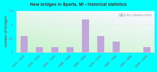
- New bridges - historical statistics
- 31920-1929
- 11930-1939
- 11940-1949
- 11950-1959
- 61960-1969
- 31970-1979
- 21980-1989
- 12000-2009
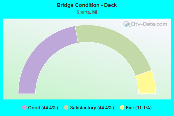
- Bridge Condition - Deck
- 44.4%Good
- 44.4%Satisfactory
- 11.1%Fair
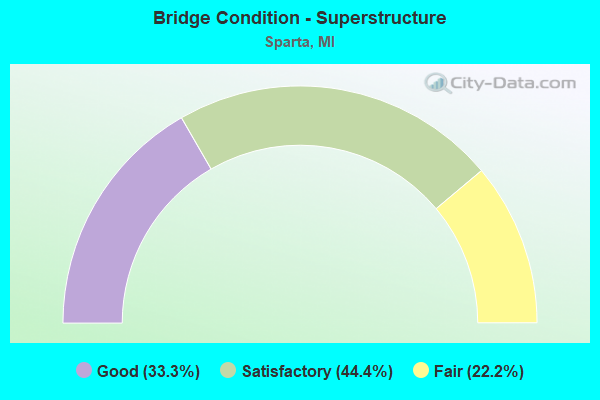
- Bridge Condition - Superstructure
- 33.3%Good
- 44.4%Satisfactory
- 22.2%Fair
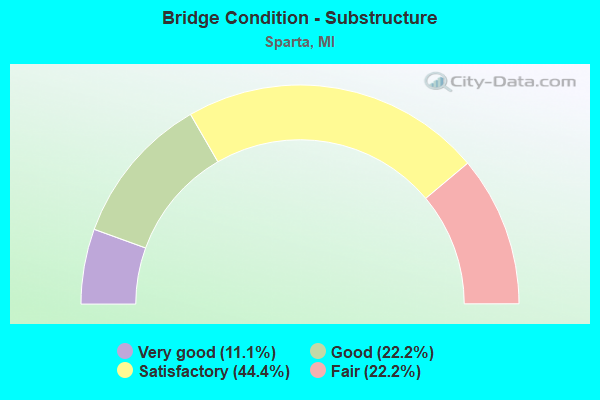
- Bridge Condition - Substructure
- 11.1%Very good
- 22.2%Good
- 44.4%Satisfactory
- 22.2%Fair
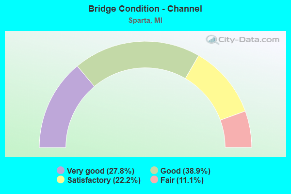
- Bridge Condition - Channel
- 27.8%Very good
- 38.9%Good
- 22.2%Satisfactory
- 11.1%Fair
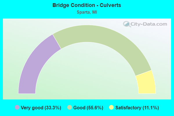
- Bridge Condition - Culverts
- 33.3%Very good
- 55.6%Good
- 11.1%Satisfactory
Find on map >> Show street view
Structure Number: 4849, Location: 4.8 MI S OF M-46 (Lat: 43.163722, Lng: -85.724389), Route carried "on" structure: State highway 37, Year Built: 1962, Status: Open, Structure Length: 2.74m (8.99ft), Average Daily Traffic: 10,377 (year 2007), Truck Traffic: 14%, Average Future Daily Traffic: 6,599 (year 2018), Design Load: HS 20, Features Intersected: NASH CREEK
Minimum Vertical Clearance: 30.48m (100.00ft), Kilometerpoint: 21.479, Lanes on structure: 3, Base Highway Network: Yes (Inventory Route: 42, Subroute: 10), Owner: State Highway Agency, Approaching Roadway Width: 12.2m (40.0ft), Material/Design: Prestressed concrete, Design/Construction: Stringer/Multi-beam, Number Of Spans In Main Unit: 3, Length of Maximum Span: 9.1m (29.9ft), Curb-To-Curb Width: 15.9m (52.2ft), Out-to-Out Width: 17.4m (57.1ft)
Condition: Deck: Satisfactory, Superstructure: Satisfactory, Substructure: Satisfactory, Channel: Good, Operating Rating: 64.5 metric tons, Method Used To Determine Operating Rating: Load Factor (LF) rating reported by rating factor (RF) method using MS18 loading, Inventory Rating: 38.6 metric tons, Method Used To Determine Inventory Rating: Load Factor (LF) rating reported by rating factor (RF) method using MS18 loading, Structural Evaluation: Equal to present minimum criteria, Deck Geometry: Better than present minimum criteria, Waterway Adequacy: Somewhat better than minimum adequacy, Approach Roadway Alignment: Equal to present desirable criteria, Designated Inspection Frequency: Every 24 months, Inspection Date: April 2021, Deck Structure Type: Concrete Cast-file-Place, Wearing Surface/Protective System: Wearing Surface: Latex Concrete
Find on map >> Show street view
Structure Number: 4852, Location: 0.5 MI S OF 12 MI RD (Lat: 43.138592, Lng: -85.717964), Route carried "on" structure: State highway 37, Year Built: 1923, Status: Open, Structure Length: 0.61m (2.00ft), Average Daily Traffic: 10,377 (year 2007), Truck Traffic: 14%, Average Future Daily Traffic: 6,599 (year 2018), Design Load: HS 20+Mod, Features Intersected: OLSON CREEK
Minimum Vertical Clearance: 30.48m (100.00ft), Kilometerpoint: 18.568, Lanes on structure: 2, Base Highway Network: Yes (Inventory Route: 42, Subroute: 10), Owner: State Highway Agency, Approaching Roadway Width: 11.0m (36.1ft), Material/Design: Concrete, Design/Construction: Culvert, Number Of Spans In Main Unit: 2, Length of Maximum Span: 2.7m (8.9ft)
Condition: Channel: Good, Culverts: Good, Operating Rating: 65.4 metric tons, Method Used To Determine Operating Rating: Load Factor (LF) rating reported by rating factor (RF) method using MS18 loading, Inventory Rating: 39.2 metric tons, Method Used To Determine Inventory Rating: Load Factor (LF) rating reported by rating factor (RF) method using MS18 loading, Structural Evaluation: Better than present minimum criteria, Waterway Adequacy: Equal to present minimum criteria, Approach Roadway Alignment: Equal to present minimum criteria, Designated Inspection Frequency: Every 24 months, Inspection Date: January 2022
Find on map >> Show street view
Structure Number: 5033, Location: 0.40 MI E OF SPARTA AVE (Lat: 43.160689, Lng: -85.701622), Route carried "on" structure: County highway 4170, Year Built: 1967, Status: Open, Structure Length: 1.31m (4.30ft), Average Daily Traffic: 9,367 (year 2005), Average Future Daily Traffic: 15,920 (year 2025), Design Load: HS 20+Mod, Features Intersected: NASH CREEK, Facility Carried by Structure: 13 MILE ROAD
Minimum Vertical Clearance: 30.48m (100.00ft), Kilometerpoint: 7.213, Lanes on structure: 4, Owner: County Highway Agency, Approaching Roadway Width: 13.1m (43.0ft), Material/Design: Steel, Design/Construction: Culvert, Number Of Spans In Main Unit: 2, Length of Maximum Span: 6.1m (20.0ft)
Condition: Channel: Very good, Culverts: Satisfactory, Operating Rating: 42.1 metric tons, Method Used To Determine Operating Rating: Load Factor (LF) rating reported by rating factor (RF) method using MS18 loading, Inventory Rating: 35.3 metric tons, Method Used To Determine Inventory Rating: Load Factor (LF) rating reported by rating factor (RF) method using MS18 loading, Structural Evaluation: Equal to present minimum criteria, Waterway Adequacy: Equal to present desirable criteria, Approach Roadway Alignment: Equal to present desirable criteria, Designated Inspection Frequency: Every 24 months, Inspection Date: October 2021
Find on map >> Show street view
Structure Number: 5041, Location: 0.20 MI N OF 12 MILE RD (Lat: 43.150033, Lng: -85.769978), Route carried "on" structure: County highway 4105, Year Built: 1940, Status: Open, Structure Length: 0.82m (2.69ft), Average Daily Traffic: 4,589 (year 2004), Average Future Daily Traffic: 7,800 (year 2024), Design Load: HS 20+Mod, Features Intersected: NASH CREEK, Facility Carried by Structure: FRUIT RIDGE AVE
Minimum Vertical Clearance: 30.48m (100.00ft), Kilometerpoint: 15.009, Lanes on structure: 2, Owner: County Highway Agency, Approaching Roadway Width: 9.1m (29.9ft), Material/Design: Concrete, Design/Construction: Tee Beam, Number Of Spans In Main Unit: 1, Length of Maximum Span: 7.3m (24.0ft), Curb-To-Curb Width: 9.8m (32.2ft), Out-to-Out Width: 10.3m (33.8ft)
Condition: Deck: Good, Superstructure: Satisfactory, Substructure: Very good, Channel: Very good, Operating Rating: 66.4 metric tons, Method Used To Determine Operating Rating: Load Factor (LF), Inventory Rating: 39.8 metric tons, Method Used To Determine Inventory Rating: Load Factor (LF), Structural Evaluation: Equal to present minimum criteria, Deck Geometry: Meets minimum limits, Waterway Adequacy: Equal to present desirable criteria, Approach Roadway Alignment: Equal to present desirable criteria, Designated Inspection Frequency: Every 24 months, Inspection Date: October 2021, Deck Structure Type: Concrete Cast-file-Place, Wearing Surface/Protective System: Wearing Surface: Bituminous
Find on map >> Show street view
Structure Number: 5042, Location: 0.23 MI N OF DIVISION ST (Lat: 43.164308, Lng: -85.710178), Route carried "on" structure: City street , Year Built: 1975, Status: Open, Structure Length: 1.37m (4.49ft), Average Daily Traffic: 5,969 (year 2005), Average Future Daily Traffic: 10,150 (year 2025), Design Load: HS 20+Mod, Features Intersected: NASH CREEK, Facility Carried by Structure: STATE STREET
Minimum Vertical Clearance: 30.48m (100.00ft), Kilometerpoint: 4.534, Lanes on structure: 2, Owner: County Highway Agency, Approaching Roadway Width: 11.3m (37.1ft), Skew: 4 degrees, Material/Design: Steel, Design/Construction: Culvert, Number Of Spans In Main Unit: 3, Length of Maximum Span: 4.8m (15.7ft)
Condition: Channel: Satisfactory, Culverts: Good, Operating Rating: 70.0 metric tons, Method Used To Determine Operating Rating: Load Factor (LF) rating reported by rating factor (RF) method using MS18 loading, Inventory Rating: 66.7 metric tons, Method Used To Determine Inventory Rating: Load Factor (LF) rating reported by rating factor (RF) method using MS18 loading, Structural Evaluation: Better than present minimum criteria, Waterway Adequacy: Equal to present desirable criteria, Approach Roadway Alignment: Equal to present desirable criteria, Designated Inspection Frequency: Every 24 months, Inspection Date: October 2021
Find on map >> Show street view
Structure Number: 5043, Location: 0.40 MI N OF 15 MILE RD (Lat: 43.195728, Lng: -85.710872), Route carried "on" structure: County highway , Year Built: 1985, Status: Open, Structure Length: 1.03m (3.38ft), Average Daily Traffic: 5,813 (year 2004), Average Future Daily Traffic: 9,880 (year 2024), Design Load: HS 20+Mod, Features Intersected: BALL CREEK, Facility Carried by Structure: SPARTA AVE
Minimum Vertical Clearance: 30.48m (100.00ft), Kilometerpoint: 0.196, Lanes on structure: 2, Owner: County Highway Agency, Approaching Roadway Width: 8.5m (27.9ft), Skew: 3 degrees, Material/Design: Prestressed concrete, Design/Construction: Box Beam or Girders - Multiple, Number Of Spans In Main Unit: 1, Length of Maximum Span: 8.5m (27.9ft), Curb-To-Curb Width: 13.4m (44.0ft), Out-to-Out Width: 14.2m (46.6ft)
Condition: Deck: Good, Superstructure: Good, Substructure: Satisfactory, Channel: Good, Operating Rating: 47.3 metric tons, Method Used To Determine Operating Rating: Load Factor (LF), Inventory Rating: 28.4 metric tons, Method Used To Determine Inventory Rating: Load Factor (LF), Structural Evaluation: Equal to present minimum criteria, Deck Geometry: Equal to present minimum criteria, Waterway Adequacy: Equal to present desirable criteria, Approach Roadway Alignment: Equal to present desirable criteria, Designated Inspection Frequency: Every 24 months, Inspection Date: October 2021, Deck Structure Type: Concrete Cast-file-Place, Wearing Surface/Protective System: Wearing Surface: Bituminous, Membrane: Preformed Fabric, Deck Protection: Epoxy Coated Reinforcing
Find on map >> Show street view
Structure Number: 5047, Location: 0.30 MI NE OF 12 MILE RD (Lat: 43.149131, Lng: -85.685319), Route carried "on" structure: County highway 4119, Year Built: 2007, Status: Open, Structure Length: 2.13m (6.99ft), Average Daily Traffic: 2,946 (year 2005), Average Future Daily Traffic: 5,010 (year 2025), Design Load: HS 20+Mod, Features Intersected: UNNAMED CREEK, Facility Carried by Structure: ALPINE AVE
Minimum Vertical Clearance: 30.48m (100.00ft), Kilometerpoint: 6.534, Lanes on structure: 2, Owner: County Highway Agency, Approaching Roadway Width: 7.3m (24.0ft), Material/Design: Steel, Design/Construction: Culvert, Number Of Spans In Main Unit: 3, Length of Maximum Span: 2.1m (6.9ft)
Condition: Channel: Good, Culverts: Very good, Operating Rating: 56.7 metric tons, Method Used To Determine Operating Rating: Load Factor (LF) rating reported by rating factor (RF) method using MS18 loading, Inventory Rating: 54.8 metric tons, Method Used To Determine Inventory Rating: Load Factor (LF) rating reported by rating factor (RF) method using MS18 loading, Structural Evaluation: Equal to present desirable criteria, Waterway Adequacy: Equal to present desirable criteria, Approach Roadway Alignment: Somewhat better than minimum adequacy, Designated Inspection Frequency: Every 24 months, Inspection Date: September 2020
Find on map >> Show street view
Structure Number: 5048, Location: 0.40 MI NE OF 12 MILE RD (Lat: 43.153533, Lng: -85.685475), Route carried "on" structure: County highway 4119, Year Built: 1963, Status: Open, Structure Length: 2.74m (8.99ft), Average Daily Traffic: 2,946 (year 2005), Average Future Daily Traffic: 5,010 (year 2025), Design Load: HS 20+Mod, Features Intersected: ROGUE RIVER, Facility Carried by Structure: ALPINE AVE
Minimum Vertical Clearance: 30.48m (100.00ft), Kilometerpoint: 7.002, Lanes on structure: 2, Owner: County Highway Agency, Approaching Roadway Width: 6.7m (22.0ft), Material/Design: Prestressed concrete, Design/Construction: Box Beam or Girders - Multiple, Number Of Spans In Main Unit: 2, Length of Maximum Span: 12.5m (41.0ft), Curb or Sidewalk Widths: Left: 0.7m (2.3ft), Right: 0.7m (2.3ft), Curb-To-Curb Width: 9.1m (29.9ft), Out-to-Out Width: 11.4m (37.4ft)
Condition: Deck: Good, Superstructure: Good, Substructure: Good, Channel: Very good, Operating Rating: 65.5 metric tons, Method Used To Determine Operating Rating: Load Factor (LF), Inventory Rating: 39.3 metric tons, Method Used To Determine Inventory Rating: Load Factor (LF), Structural Evaluation: Better than present minimum criteria, Deck Geometry: Meets minimum limits, Waterway Adequacy: Equal to present desirable criteria, Approach Roadway Alignment: Equal to present minimum criteria, Designated Inspection Frequency: Every 24 months, Inspection Date: September 2020, Deck Structure Type: Concrete Cast-file-Place, Wearing Surface/Protective System: Wearing Surface: Bituminous
Find on map >> Show street view
Structure Number: 5051, Location: 0.50 MI N OF 10 MILE RD (Lat: 43.123956, Lng: -85.650792), Route carried "on" structure: County highway , Year Built: 1924, Status: Open, Structure Length: 3.05m (10.01ft), Average Daily Traffic: 3,797 (year 2014), Truck Traffic: 8%, Average Future Daily Traffic: 4,936 (year 2034), Design Load: HS 20+Mod, Features Intersected: ROGUE RIVER, Facility Carried by Structure: PINE ISLAND DRIVE
Minimum Vertical Clearance: 30.48m (100.00ft), Kilometerpoint: 9.143, Lanes on structure: 2, Owner: County Highway Agency, Approaching Roadway Width: 7.9m (25.9ft), Material/Design: Concrete, Design/Construction: Girder and Floorbeam System, Number Of Spans In Main Unit: 1, Length of Maximum Span: 28.1m (92.2ft), Curb or Sidewalk Widths: Left: 0.2m (0.7ft), Right: 0.2m (0.7ft), Curb-To-Curb Width: 6.1m (20.0ft), Out-to-Out Width: 8.0m (26.2ft)
Condition: Deck: Good, Superstructure: Good, Substructure: Satisfactory, Channel: Very good, Operating Rating: 29.0 metric tons, Method Used To Determine Operating Rating: Load Factor (LF), Inventory Rating: 17.4 metric tons, Method Used To Determine Inventory Rating: Load Factor (LF), Structural Evaluation: Meets minimum limits, Deck Geometry: High priority of replacement, Waterway Adequacy: Equal to present desirable criteria, Approach Roadway Alignment: Meets minimum limits, Length Of Structure Improvement: 20.00m (65.62ft), Designated Inspection Frequency: Every 24 months, Inspection Date: October 2020, Bridge Improvement Cost: $500,000, Roadway Improvement Cost: $100,000, Total Project Cost: $600,000, Deck Structure Type: Concrete Cast-file-Place, Wearing Surface/Protective System: Wearing Surface: Epoxy Overlay
Find on map >> Show street view
Structure Number: 5106, Location: 0.20 MI N OF 11 MILE RD (Lat: 43.134511, Lng: -85.670356), Route carried "on" structure: County highway , Year Built: 1976, Status: Open, Structure Length: 4.20m (13.78ft), Average Daily Traffic: 2,197 (year 2004), Average Future Daily Traffic: 3,730 (year 2024), Design Load: HS 20+Mod, Features Intersected: ROGUE RIVER, Facility Carried by Structure: DIVISION AVE
Minimum Vertical Clearance: 30.48m (100.00ft), Kilometerpoint: 3.607, Lanes on structure: 2, Owner: County Highway Agency, Approaching Roadway Width: 8.5m (27.9ft), Skew: 3 degrees, Material/Design: Prestressed concrete, Design/Construction: Box Beam or Girders - Multiple, Number Of Spans In Main Unit: 3, Length of Maximum Span: 13.1m (43.0ft), Curb-To-Curb Width: 9.8m (32.2ft), Out-to-Out Width: 10.2m (33.5ft)
Condition: Deck: Satisfactory, Superstructure: Satisfactory, Substructure: Fair, Channel: Good, Operating Rating: 54.0 metric tons, Method Used To Determine Operating Rating: Load Factor (LF), Inventory Rating: 32.4 metric tons, Method Used To Determine Inventory Rating: Load Factor (LF), Structural Evaluation: Somewhat better than minimum adequacy, Deck Geometry: Meets minimum limits, Waterway Adequacy: Equal to present desirable criteria, Approach Roadway Alignment: Equal to present desirable criteria, Designated Inspection Frequency: Every 24 months, Inspection Date: October 2021, Deck Structure Type: Concrete Precast Panels, Wearing Surface/Protective System: Wearing Surface: Bituminous
Find on map >> Show street view
Structure Number: 5114, Location: 0.70 MI N OF 8 MILE RD (Lat: 43.096914, Lng: -85.719467), Route carried "on" structure: County highway , Year Built: 1969, Status: Open, Structure Length: 0.88m (2.89ft), Average Daily Traffic: 943 (year 2004), Average Future Daily Traffic: 1,600 (year 2024), Design Load: HS 20+Mod, Features Intersected: MILL CREEK, Facility Carried by Structure: BAUMHOFF AVE
Minimum Vertical Clearance: 30.48m (100.00ft), Kilometerpoint: 7.479, Lanes on structure: 2, Owner: County Highway Agency, Approaching Roadway Width: 6.7m (22.0ft), Skew: 2 degrees, Material/Design: Steel, Design/Construction: Culvert, Number Of Spans In Main Unit: 2, Length of Maximum Span: 4.2m (13.8ft)
Condition: Channel: Good, Culverts: Very good, Operating Rating: 43.4 metric tons, Method Used To Determine Operating Rating: Load Factor (LF) rating reported by rating factor (RF) method using MS18 loading, Inventory Rating: 36.3 metric tons, Method Used To Determine Inventory Rating: Load Factor (LF) rating reported by rating factor (RF) method using MS18 loading, Structural Evaluation: Equal to present desirable criteria, Waterway Adequacy: Equal to present desirable criteria, Approach Roadway Alignment: Equal to present desirable criteria, Designated Inspection Frequency: Every 24 months, Inspection Date: October 2021
Find on map >> Show street view
Structure Number: 5167, Location: 0.30 MI W OF LONG LK AVE (Lat: 43.196761, Lng: -85.687086), Route carried "on" structure: County highway , Year Built: 1971, Status: Open, Structure Length: 2.65m (8.69ft), Average Daily Traffic: 1,347 (year 2004), Average Future Daily Traffic: 2,290 (year 2024), Design Load: HS 20+Mod, Features Intersected: ROGUE RIVER, Facility Carried by Structure: INDIAN LAKES ROAD
Minimum Vertical Clearance: 30.48m (100.00ft), Kilometerpoint: 1.922, Lanes on structure: 2, Owner: County Highway Agency, Approaching Roadway Width: 6.7m (22.0ft), Skew: 1 degrees, Material/Design: Prestressed concrete, Design/Construction: Box Beam or Girders - Multiple, Number Of Spans In Main Unit: 2, Length of Maximum Span: 13.4m (44.0ft), Curb-To-Curb Width: 9.8m (32.2ft), Out-to-Out Width: 10.2m (33.5ft)
Condition: Deck: Satisfactory, Superstructure: Satisfactory, Substructure: Good, Channel: Satisfactory, Operating Rating: 47.8 metric tons, Method Used To Determine Operating Rating: Load Factor (LF), Inventory Rating: 28.6 metric tons, Method Used To Determine Inventory Rating: Load Factor (LF), Structural Evaluation: Equal to present minimum criteria, Deck Geometry: Somewhat better than minimum adequacy, Waterway Adequacy: Equal to present desirable criteria, Approach Roadway Alignment: Equal to present minimum criteria, Designated Inspection Frequency: Every 24 months, Inspection Date: October 2021, Deck Structure Type: Concrete Precast Panels, Wearing Surface/Protective System: Wearing Surface: Bituminous
Find on map >> Show street view
Structure Number: 517, Location: 150 FT N OF 13 MI RD (Lat: 43.161258, Lng: -85.730142), Route carried "on" structure: County highway , Year Built: 1964, Status: Open, Structure Length: 1.70m (5.58ft), Average Daily Traffic: 584 (year 2004), Average Future Daily Traffic: 990 (year 2024), Design Load: HS 20+Mod, Features Intersected: NASH CREEK, Facility Carried by Structure: PHELPS AVE
Minimum Vertical Clearance: 30.48m (100.00ft), Kilometerpoint: 0.072, Lanes on structure: 2, Owner: County Highway Agency, Approaching Roadway Width: 6.7m (22.0ft), Material/Design: Steel, Design/Construction: Culvert, Number Of Spans In Main Unit: 3, Length of Maximum Span: 6.1m (20.0ft)
Condition: Channel: Fair, Culverts: Very good, Operating Rating: 40.2 metric tons, Method Used To Determine Operating Rating: Load Factor (LF) rating reported by rating factor (RF) method using MS18 loading, Inventory Rating: 33.4 metric tons, Method Used To Determine Inventory Rating: Load Factor (LF) rating reported by rating factor (RF) method using MS18 loading, Structural Evaluation: Equal to present desirable criteria, Waterway Adequacy: Equal to present desirable criteria, Approach Roadway Alignment: Equal to present minimum criteria, Designated Inspection Frequency: Every 24 months, Inspection Date: October 2021
Find on map >> Show street view
Structure Number: 5171, Location: 0.30 MI S OF INDIAN LK RD (Lat: 43.192458, Lng: -85.700936), Route carried "on" structure: County highway , Year Built: 1966, Status: Open, Structure Length: 0.94m (3.08ft), Average Daily Traffic: 455 (year 2005), Average Future Daily Traffic: 770 (year 2025), Design Load: HS 20+Mod, Features Intersected: BALL CREEK EXTN DRAIN, Facility Carried by Structure: STEBBINS AVE
Minimum Vertical Clearance: 30.48m (100.00ft), Kilometerpoint: 3.541, Lanes on structure: 2, Owner: County Highway Agency, Approaching Roadway Width: 6.7m (22.0ft), Skew: 1 degrees, Material/Design: Steel, Design/Construction: Culvert, Number Of Spans In Main Unit: 2, Length of Maximum Span: 4.5m (14.8ft)
Condition: Channel: Good, Culverts: Good, Operating Rating: 39.5 metric tons, Method Used To Determine Operating Rating: Load Factor (LF) rating reported by rating factor (RF) method using MS18 loading, Inventory Rating: 32.4 metric tons, Method Used To Determine Inventory Rating: Load Factor (LF) rating reported by rating factor (RF) method using MS18 loading, Structural Evaluation: Better than present minimum criteria, Waterway Adequacy: Equal to present desirable criteria, Approach Roadway Alignment: Equal to present desirable criteria, Designated Inspection Frequency: Every 24 months, Inspection Date: October 2021
Find on map >> Show street view
Structure Number: 5172, Location: 0.1 MI N OF 11 MILE RD (Lat: 43.132428, Lng: -85.680311), Route carried "on" structure: County highway , Year Built: 1988, Status: Open, Structure Length: 0.61m (2.00ft), Average Daily Traffic: 972 (year 2004), Average Future Daily Traffic: 1,650 (year 2024), Design Load: HS 20+Mod, Features Intersected: UNNAMED CREEK, Facility Carried by Structure: VINTON AVE
Minimum Vertical Clearance: 30.48m (100.00ft), Kilometerpoint: 3.172, Lanes on structure: 2, Owner: County Highway Agency, Approaching Roadway Width: 11.6m (38.1ft), Material/Design: Concrete, Design/Construction: Culvert, Number Of Spans In Main Unit: 2, Length of Maximum Span: 3.0m (9.8ft)
Condition: Channel: Very good, Culverts: Good, Operating Rating: 48.3 metric tons, Method Used To Determine Operating Rating: Load Factor (LF) rating reported by rating factor (RF) method using MS18 loading, Inventory Rating: 38.2 metric tons, Method Used To Determine Inventory Rating: Load Factor (LF) rating reported by rating factor (RF) method using MS18 loading, Structural Evaluation: Better than present minimum criteria, Waterway Adequacy: Equal to present desirable criteria, Approach Roadway Alignment: Equal to present desirable criteria, Designated Inspection Frequency: Every 24 months, Inspection Date: October 2021, Deck Structure Type: Concrete Cast-file-Place, Wearing Surface/Protective System: Wearing Surface: Bituminous
Find on map >> Show street view
Structure Number: 5173, Location: 0.30 MI W OF FRUIT RIDGE (Lat: 43.147042, Lng: -85.775839), Route carried "on" structure: County highway , Year Built: 1955, Status: Open, Structure Length: 0.76m (2.49ft), Average Daily Traffic: 457 (year 2004), Average Future Daily Traffic: 780 (year 2024), Design Load: HS 20+Mod, Features Intersected: NASH CREEK, Facility Carried by Structure: 12 MILE ROAD
Minimum Vertical Clearance: 30.48m (100.00ft), Kilometerpoint: 1.125, Lanes on structure: 2, Owner: County Highway Agency, Approaching Roadway Width: 6.7m (22.0ft), Material/Design: Steel, Design/Construction: Culvert, Number Of Spans In Main Unit: 2, Length of Maximum Span: 3.9m (12.8ft)
Condition: Channel: Satisfactory, Culverts: Good, Operating Rating: 39.2 metric tons, Method Used To Determine Operating Rating: Load Factor (LF) rating reported by rating factor (RF) method using MS18 loading, Inventory Rating: 32.4 metric tons, Method Used To Determine Inventory Rating: Load Factor (LF) rating reported by rating factor (RF) method using MS18 loading, Structural Evaluation: Better than present minimum criteria, Waterway Adequacy: Equal to present desirable criteria, Approach Roadway Alignment: Better than present minimum criteria, Designated Inspection Frequency: Every 24 months, Inspection Date: October 2021
Find on map >> Show street view
Structure Number: 5233, Location: 0.14 MI N OF DIVISION ST (Lat: 43.162739, Lng: -85.707175), Route carried "on" structure: City street , Year Built: 1937, Status: Open, Structure Length: 1.00m (3.28ft), Average Daily Traffic: 1,600 (year 2009), Truck Traffic: 3%, Average Future Daily Traffic: 1,600 (year 2029), Design Load: HS 20+Mod, Features Intersected: NASH CREEK, Facility Carried by Structure: UNION STREET
Minimum Vertical Clearance: 30.48m (100.00ft), Kilometerpoint: 1.843, Lanes on structure: 2, Owner: City or Municipal Highway Agency, Approaching Roadway Width: 11.6m (38.1ft), Material/Design: Steel, Design/Construction: Stringer/Multi-beam, Number Of Spans In Main Unit: 1, Length of Maximum Span: 9.1m (29.9ft), Curb or Sidewalk Widths: Left: 1.4m (4.6ft), Right: 1.4m (4.6ft), Curb-To-Curb Width: 7.9m (25.9ft), Out-to-Out Width: 11.8m (38.7ft)
Condition: Deck: Fair, Superstructure: Fair, Substructure: Satisfactory, Channel: Fair, Operating Rating: 97.2 metric tons, Method Used To Determine Operating Rating: Load and Resistance Factor Rating (LRFR) rating reported by rating factor(RF) method using HL-93 loadings, Inventory Rating: 97.2 metric tons, Method Used To Determine Inventory Rating: Load and Resistance Factor Rating (LRFR) rating reported by rating factor(RF) method using HL-93 loadings, Structural Evaluation: Somewhat better than minimum adequacy, Deck Geometry: Meets minimum limits, Waterway Adequacy: Equal to present desirable criteria, Approach Roadway Alignment: Equal to present desirable criteria, Designated Inspection Frequency: Every 12 months, Inspection Date: March 2021, Deck Structure Type: Concrete Cast-file-Place, Wearing Surface/Protective System: Wearing Surface: Bituminous
Find on map >> Show street view
Structure Number: 5234, Location: 350 FT N OF DIVISION ST (Lat: 43.161519, Lng: -85.702867), Route carried "on" structure: City street , Year Built: 1920, Year Reconstructed: 1971, Status: Open, Structure Length: 1.31m (4.30ft), Average Daily Traffic: 400 (year 2009), Truck Traffic: 3%, Average Future Daily Traffic: 400 (year 2029), Design Load: HS 20+Mod, Features Intersected: NASH CREEK, Facility Carried by Structure: LOOMIS STREET
Minimum Vertical Clearance: 30.48m (100.00ft), Kilometerpoint: 0.090, Lanes on structure: 2, Owner: City or Municipal Highway Agency, Approaching Roadway Width: 6.4m (21.0ft), Material/Design: Prestressed concrete, Design/Construction: Box Beam or Girders - Multiple, Number Of Spans In Main Unit: 1, Length of Maximum Span: 12.2m (40.0ft), Curb-To-Curb Width: 6.4m (21.0ft), Out-to-Out Width: 6.4m (21.0ft)
Condition: Deck: Satisfactory, Superstructure: Fair, Substructure: Fair, Channel: Satisfactory, Operating Rating: 55.6 metric tons, Method Used To Determine Operating Rating: Field evaluation and documented engineering judgment, Inventory Rating: 32.3 metric tons, Method Used To Determine Inventory Rating: Field evaluation and documented engineering judgment, Structural Evaluation: Somewhat better than minimum adequacy, Deck Geometry: Meets minimum limits, Waterway Adequacy: Better than present minimum criteria, Approach Roadway Alignment: Equal to present desirable criteria, Designated Inspection Frequency: Every 24 months, Inspection Date: March 2021, Deck Structure Type: Concrete Precast Panels, Wearing Surface/Protective System: Wearing Surface: Bituminous