Bridge Statistics for Springdale, Montana (MT)
Condition, Traffic, Stress, Structural Evaluation, Project Costs
- National Bridge Inventory (NBI) Statistics
- 13Number of bridges
- 115ft / 34.7mTotal length
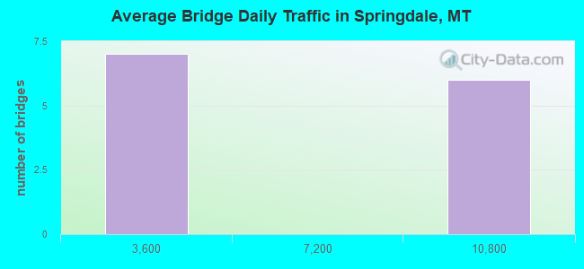
- 57,618Total average daily traffic
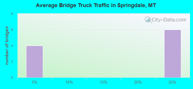
- 12,466Total average daily truck traffic
- National Bridge Inventory (NBI) Registered Bridges for Springdale
- No street view available for this location
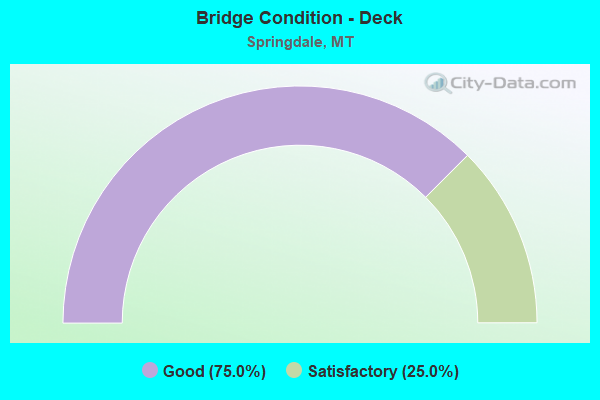
- Bridge Condition - Deck
- 75.0%Good
- 25.0%Satisfactory
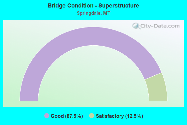
- Bridge Condition - Superstructure
- 87.5%Good
- 12.5%Satisfactory
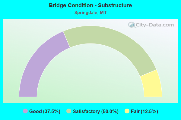
- Bridge Condition - Substructure
- 37.5%Good
- 50.0%Satisfactory
- 12.5%Fair
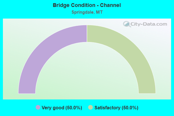
- Bridge Condition - Channel
- 50.0%Very good
- 50.0%Satisfactory
Find on map >> Show street view
Structure Number: 708, Location: 17M W BIG TIMBER (Lat: 45.765928, Lng: -110.179878), Route carried "on" structure: County highway 49028, Year Built: 1980, Status: Open, Structure Length: 0.92m (3.02ft), Average Daily Traffic: 100 (year 2022), Truck Traffic: 3%, Average Future Daily Traffic: 100 (year 2037), Features Intersected: DUCK CREEK, Facility Carried by Structure: YELLOWSTONE TRAIL
Minimum Vertical Clearance: 30+ m (98+ ft), Kilometerpoint: 11.739, Lanes on structure: 2, Owner: County Highway Agency, Approaching Roadway Width: 6.4m (21.0ft), Material/Design: Wood or Timber, Design/Construction: Stringer/Multi-beam, Number Of Spans In Main Unit: 1, Length of Maximum Span: 8.6m (28.2ft), Curb-To-Curb Width: 6.1m (20.0ft), Out-to-Out Width: 6.1m (20.0ft)
Condition: Deck: Satisfactory, Superstructure: Satisfactory, Substructure: Satisfactory, Channel: Satisfactory, Operating Rating: 59.0 metric tons, Method Used To Determine Operating Rating: Allowable Stress (AS), Inventory Rating: 44.5 metric tons, Method Used To Determine Inventory Rating: Allowable Stress (AS), Structural Evaluation: Equal to present minimum criteria, Deck Geometry: Somewhat better than minimum adequacy, Waterway Adequacy: Equal to present minimum criteria, Approach Roadway Alignment: Equal to present minimum criteria, Designated Inspection Frequency: Every 24 months, Inspection Date: August 2020, Deck Structure Type: Wood or Timber, Wearing Surface/Protective System: Wearing Surface: Bituminous
Find on map >> Show street view
Structure Number: I00090350+04551, Location: 3.7M W SPRINGDALE (Lat: 45.700778, Lng: -110.260886), Route carried "on" structure: Interstate 90, Year Built: 1987, Status: Open, Structure Length: 2.41m (7.91ft), Average Daily Traffic: 9,579 (year 2020), Truck Traffic: 22%, Average Future Daily Traffic: 10,250 (year 2040), Design Load: HS 20, Features Intersected: INT SPRINGDALE WEST
Minimum Vertical Clearance: 30+ m (98+ ft), Kilometerpoint: 560.443, Lanes on structure: 2, Lanes under structure: 2, Base Highway Network: Yes, Owner: State Highway Agency, Approaching Roadway Width: 11.3m (37.1ft), Material/Design: Concrete continuous, Design/Construction: Slab, Number Of Spans In Main Unit: 3, Length of Maximum Span: 9.1m (29.9ft), Curb-To-Curb Width: 11.0m (36.1ft), Out-to-Out Width: 11.9m (39.0ft)
Condition: Deck: Good, Superstructure: Good, Substructure: Satisfactory, Operating Rating: 64.4 metric tons, Method Used To Determine Operating Rating: Load Factor (LF), Inventory Rating: 39.0 metric tons, Method Used To Determine Inventory Rating: Load Factor (LF), Structural Evaluation: Equal to present minimum criteria, Deck Geometry: Somewhat better than minimum adequacy, Approach Roadway Alignment: Equal to present desirable criteria, Designated Inspection Frequency: Every 24 months, Inspection Date: December 2020, Deck Structure Type: Concrete Cast-file-Place, Wearing Surface/Protective System: Wearing Surface: Bituminous, Membrane: Preformed Fabric, Deck Protection: Epoxy Coated Reinforcing
Find on map >> Show street view
Structure Number: I00090350+04552, Location: 3.7M W SPRINGDALE (Lat: 45.700808, Lng: -110.261017), Route carried "on" structure: Interstate 90, Year Built: 1987, Status: Open, Structure Length: 2.41m (7.91ft), Average Daily Traffic: 9,579 (year 2020), Truck Traffic: 22%, Average Future Daily Traffic: 10,250 (year 2040), Design Load: HS 20, Features Intersected: INT SPRINGDALE WEST
Minimum Vertical Clearance: 30+ m (98+ ft), Kilometerpoint: 560.610, Lanes on structure: 2, Lanes under structure: 2, Base Highway Network: Yes, Owner: State Highway Agency, Approaching Roadway Width: 11.3m (37.1ft), Material/Design: Concrete continuous, Design/Construction: Slab, Number Of Spans In Main Unit: 3, Length of Maximum Span: 9.1m (29.9ft), Curb-To-Curb Width: 11.0m (36.1ft), Out-to-Out Width: 11.9m (39.0ft)
Condition: Deck: Good, Superstructure: Good, Substructure: Satisfactory, Operating Rating: 64.4 metric tons, Method Used To Determine Operating Rating: Load Factor (LF), Inventory Rating: 39.0 metric tons, Method Used To Determine Inventory Rating: Load Factor (LF), Structural Evaluation: Equal to present minimum criteria, Deck Geometry: Somewhat better than minimum adequacy, Approach Roadway Alignment: Equal to present desirable criteria, Designated Inspection Frequency: Every 24 months, Inspection Date: December 2020, Deck Structure Type: Concrete Cast-file-Place, Wearing Surface/Protective System: Wearing Surface: Bituminous, Membrane: Preformed Fabric, Deck Protection: Epoxy Coated Reinforcing
Find on map >> Show street view
Structure Number: I00090354+03151, Location: SPRINGDALE (Lat: 45.736933, Lng: -110.214606), Route carried "on" structure: Interstate 90, Year Built: 1981, Status: Open, Structure Length: 3.78m (12.40ft), Average Daily Traffic: 9,368 (year 2020), Truck Traffic: 22%, Average Future Daily Traffic: 10,024 (year 2040), Design Load: HS 20, Features Intersected: INT SPRINGDALE
Minimum Vertical Clearance: 30+ m (98+ ft), Kilometerpoint: 566.662, Lanes on structure: 2, Lanes under structure: 2, Base Highway Network: Yes, Owner: State Highway Agency, Approaching Roadway Width: 11.6m (38.1ft), Material/Design: Prestressed concrete, Design/Construction: Stringer/Multi-beam, Number Of Spans In Main Unit: 3, Length of Maximum Span: 18.3m (60.0ft), Curb or Sidewalk Widths: Left: 0.2m (0.7ft), Right: 0.2m (0.7ft), Curb-To-Curb Width: 12.6m (41.3ft), Out-to-Out Width: 13.5m (44.3ft)
Condition: Deck: Good, Superstructure: Good, Substructure: Good, Operating Rating: 73.4 metric tons, Method Used To Determine Operating Rating: Load Factor (LF), Inventory Rating: 34.7 metric tons, Method Used To Determine Inventory Rating: Load Factor (LF), Structural Evaluation: Better than present minimum criteria, Deck Geometry: Better than present minimum criteria, Underclear: Meets minimum limits, Approach Roadway Alignment: Equal to present desirable criteria, Designated Inspection Frequency: Every 48 months, Inspection Date: September 2019, Deck Structure Type: Concrete Cast-file-Place, Wearing Surface/Protective System: Wearing Surface: Monolithic Concrete
Find on map >> Show street view
Structure Number: I00090354+03152, Location: SPRINGDALE (Lat: 45.737158, Lng: -110.214672), Route carried "on" structure: Interstate 90, Year Built: 1981, Status: Open, Structure Length: 3.78m (12.40ft), Average Daily Traffic: 9,368 (year 2020), Truck Traffic: 22%, Average Future Daily Traffic: 10,024 (year 2040), Design Load: HS 20, Features Intersected: INT SPRINGDALE
Minimum Vertical Clearance: 30+ m (98+ ft), Kilometerpoint: 566.840, Lanes on structure: 2, Lanes under structure: 2, Base Highway Network: Yes, Owner: State Highway Agency, Approaching Roadway Width: 11.6m (38.1ft), Material/Design: Prestressed concrete, Design/Construction: Stringer/Multi-beam, Number Of Spans In Main Unit: 3, Length of Maximum Span: 18.3m (60.0ft), Curb-To-Curb Width: 12.6m (41.3ft), Out-to-Out Width: 13.5m (44.3ft)
Condition: Deck: Good, Superstructure: Good, Substructure: Good, Operating Rating: 73.4 metric tons, Method Used To Determine Operating Rating: Load Factor (LF), Inventory Rating: 34.7 metric tons, Method Used To Determine Inventory Rating: Load Factor (LF), Structural Evaluation: Better than present minimum criteria, Deck Geometry: Better than present minimum criteria, Underclear: Meets minimum limits, Approach Roadway Alignment: Equal to present desirable criteria, Designated Inspection Frequency: Every 48 months, Inspection Date: September 2019, Deck Structure Type: Concrete Cast-file-Place, Wearing Surface/Protective System: Wearing Surface: Monolithic Concrete
Find on map >> Show street view
Structure Number: I00090357+02211, Location: 3.1M E SPRINGDALE (Lat: 45.750953, Lng: -110.157975), Route carried "on" structure: Interstate 90, Year Built: 1981, Status: Open, Structure Length: 3.51m (11.52ft), Average Daily Traffic: 9,368 (year 2020), Truck Traffic: 22%, Average Future Daily Traffic: 10,024 (year 2040), Design Load: HS 20, Features Intersected: JARRETT CR FARM ACCESS
Minimum Vertical Clearance: 30+ m (98+ ft), Kilometerpoint: 571.337, Lanes on structure: 2, Base Highway Network: Yes, Owner: State Highway Agency, Approaching Roadway Width: 11.6m (38.1ft), Material/Design: Prestressed concrete, Design/Construction: Stringer/Multi-beam, Number Of Spans In Main Unit: 3, Length of Maximum Span: 16.2m (53.1ft), Curb-To-Curb Width: 12.6m (41.3ft), Out-to-Out Width: 13.5m (44.3ft)
Condition: Deck: Good, Superstructure: Good, Substructure: Satisfactory, Channel: Very good, Operating Rating: 73.8 metric tons, Method Used To Determine Operating Rating: Load Factor (LF), Inventory Rating: 44.2 metric tons, Method Used To Determine Inventory Rating: Load Factor (LF), Structural Evaluation: Equal to present minimum criteria, Deck Geometry: Better than present minimum criteria, Waterway Adequacy: Superior to present desirable criteria, Approach Roadway Alignment: Equal to present desirable criteria, Designated Inspection Frequency: Every 48 months, Inspection Date: September 2019, Deck Structure Type: Concrete Cast-file-Place, Wearing Surface/Protective System: Wearing Surface: Monolithic Concrete
Find on map >> Show street view
Structure Number: I00090357+02212, Location: 3.1M E SPRINGDALE (Lat: 45.751219, Lng: -110.158117), Route carried "on" structure: Interstate 90, Year Built: 1981, Status: Open, Structure Length: 3.51m (11.52ft), Average Daily Traffic: 9,368 (year 2020), Truck Traffic: 22%, Average Future Daily Traffic: 10,024 (year 2040), Design Load: HS 20, Features Intersected: JARRETT CR FARM ACCESS
Minimum Vertical Clearance: 30+ m (98+ ft), Kilometerpoint: 571.515, Lanes on structure: 2, Lanes under structure: 2, Base Highway Network: Yes, Owner: State Highway Agency, Approaching Roadway Width: 11.6m (38.1ft), Material/Design: Prestressed concrete, Design/Construction: Stringer/Multi-beam, Number Of Spans In Main Unit: 3, Length of Maximum Span: 16.2m (53.1ft), Curb-To-Curb Width: 12.6m (41.3ft), Out-to-Out Width: 13.5m (44.3ft)
Condition: Deck: Good, Superstructure: Good, Substructure: Good, Channel: Very good, Operating Rating: 73.8 metric tons, Method Used To Determine Operating Rating: Load Factor (LF), Inventory Rating: 44.2 metric tons, Method Used To Determine Inventory Rating: Load Factor (LF), Structural Evaluation: Better than present minimum criteria, Deck Geometry: Better than present minimum criteria, Underclear: Meets minimum limits, Waterway Adequacy: Superior to present desirable criteria, Approach Roadway Alignment: Equal to present desirable criteria, Designated Inspection Frequency: Every 48 months, Inspection Date: September 2019, Deck Structure Type: Concrete Cast-file-Place, Wearing Surface/Protective System: Wearing Surface: Monolithic Concrete
Find on map >> Show street view
Structure Number: S00563000+09061, Location: 1M N SPRINGDALE (Lat: 45.743958, Lng: -110.232767), Route carried "on" structure: County highway 34563, Year Built: 1980, Status: Open, Structure Length: 14.38m (47.18ft), Average Daily Traffic: 196 (year 2020), Average Future Daily Traffic: 226 (year 2040), Design Load: HS 20, Features Intersected: YELLOWSTONE RIVER 077, Facility Carried by Structure: OLD STAGE ROAD
Minimum Vertical Clearance: 30+ m (98+ ft), Kilometerpoint: 2.026, Lanes on structure: 2, Owner: County Highway Agency, Approaching Roadway Width: 9.8m (32.2ft), Skew: 2 degrees, Material/Design: Prestressed concrete, Design/Construction: Stringer/Multi-beam, Number Of Spans In Main Unit: 4, Length of Maximum Span: 37.0m (121.4ft), Curb-To-Curb Width: 9.5m (31.2ft), Out-to-Out Width: 10.5m (34.4ft)
Condition: Deck: Satisfactory, Superstructure: Good, Substructure: Fair, Channel: Satisfactory, Operating Rating: 74.3 metric tons, Method Used To Determine Operating Rating: Assigned rating based on Load Factor Design (LFD) reported in metric tons, Inventory Rating: 32.7 metric tons, Method Used To Determine Inventory Rating: Assigned rating based on Load Factor Design (LFD) reported in metric tons, Structural Evaluation: Somewhat better than minimum adequacy, Deck Geometry: Equal to present minimum criteria, Waterway Adequacy: Equal to present desirable criteria, Approach Roadway Alignment: Equal to present desirable criteria, Designated Inspection Frequency: Every 24 months, Underwater Inspection Frequency: Every 60 months, Inspection Date: September 2020, Underwater Inspection Date: September 2019, Deck Structure Type: Concrete Cast-file-Place
Find on map >> Show street view
Structure Number: I00090350+04551, Location: 37M W SPRINGDALE (Lat: 45.700778, Lng: -110.260886), Route carried "under" structure: ServiceState highway 34448, Year Built: 1987, Structure Length: 0. m, Average Daily Traffic: 100 (year 2022), Truck Traffic: 3%, Features Intersected: INT SPRINGDALE WEST, Facility Carried by Structure: I 90
Minimum Vertical Clearance: 4.69m (15.39ft), Kilometerpoint: 11.627, Lanes on structure: 2, Lanes under structure: 2, Material/Design: Concrete continuous, Design/Construction: Slab, Length of Maximum Span: 9.1m (29.9ft)
Find on map >> Show street view
Structure Number: I00090350+04552, Location: 37M W SPRINGDALE (Lat: 45.700808, Lng: -110.261017), Route carried "under" structure: ServiceState highway 34448, Year Built: 1987, Structure Length: 0. m, Average Daily Traffic: 100 (year 2022), Truck Traffic: 3%, Features Intersected: INT SPRINGDALE WEST, Facility Carried by Structure: I 90
Minimum Vertical Clearance: 4.69m (15.39ft), Kilometerpoint: 11.637, Lanes on structure: 2, Lanes under structure: 2, Material/Design: Concrete continuous, Design/Construction: Slab, Length of Maximum Span: 9.1m (29.9ft)
Find on map >> Show street view
Structure Number: I00090354+03151, Location: SPRINGDALE (Lat: 45.736933, Lng: -110.214606), Route carried "under" structure: ServiceCounty highway 49563, Year Built: 1981, Structure Length: 0. m, Average Daily Traffic: 196 (year 2020), Features Intersected: INT SPRINGDALE, Facility Carried by Structure: I 90
Minimum Vertical Clearance: 5.23m (17.16ft), Kilometerpoint: 0.001, Lanes on structure: 2, Lanes under structure: 2, Material/Design: Prestressed concrete, Design/Construction: Stringer/Multi-beam, Length of Maximum Span: 18.3m (60.0ft)
Find on map >> Show street view
Structure Number: I00090354+03152, Location: SPRINGDALE (Lat: 45.737158, Lng: -110.214672), Route carried "under" structure: ServiceCounty highway 49563, Year Built: 1981, Structure Length: 0. m, Average Daily Traffic: 196 (year 2020), Features Intersected: INT SPRINGDALE, Facility Carried by Structure: I 90
Minimum Vertical Clearance: 5.23m (17.16ft), Kilometerpoint: 0.023, Lanes on structure: 2, Lanes under structure: 2, Material/Design: Prestressed concrete, Design/Construction: Stringer/Multi-beam, Length of Maximum Span: 18.3m (60.0ft)
Find on map >> Show street view
Structure Number: I00090357+02212, Location: 31M E SPRINGDALE (Lat: 45.751219, Lng: -110.158117), Route carried "under" structure: ServiceState highway 49113, Year Built: 1981, Structure Length: 0. m, Average Daily Traffic: 100 (year 2022), Truck Traffic: 3%, Features Intersected: JARRETT CR FARM ACCESS, Facility Carried by Structure: I 90
Minimum Vertical Clearance: 4.39m (14.40ft), Kilometerpoint: 0.046, Lanes on structure: 2, Lanes under structure: 2, Material/Design: Prestressed concrete, Design/Construction: Stringer/Multi-beam, Length of Maximum Span: 16.2m (53.1ft)