Bridge Statistics for Springdale, Wisconsin (WI)
Condition, Traffic, Stress, Structural Evaluation, Project Costs
- National Bridge Inventory (NBI) Statistics
- 21Number of bridges
- 157ft / 47.8mTotal length
- $911,000Total costs
- 153,382Total average daily traffic
- 9,263Total average daily truck traffic
- National Bridge Inventory (NBI) Registered Bridges for Springdale
- No street view available for this location
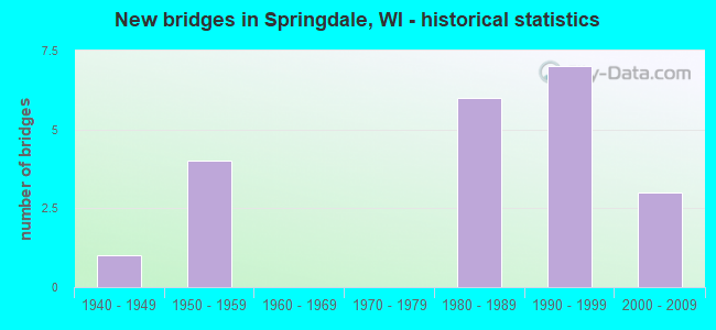
- New bridges - historical statistics
- 11940-1949
- 41950-1959
- 61980-1989
- 71990-1999
- 32000-2009
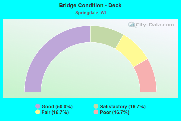
- Bridge Condition - Deck
- 50.0%Good
- 16.7%Satisfactory
- 16.7%Fair
- 16.7%Poor
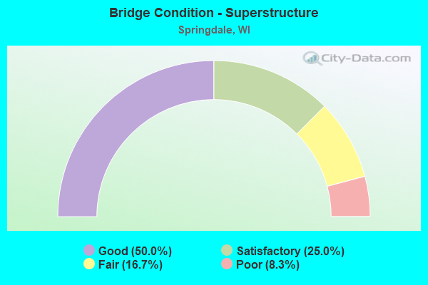
- Bridge Condition - Superstructure
- 50.0%Good
- 25.0%Satisfactory
- 16.7%Fair
- 8.3%Poor
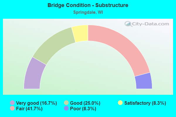
- Bridge Condition - Substructure
- 16.7%Very good
- 25.0%Good
- 8.3%Satisfactory
- 41.7%Fair
- 8.3%Poor
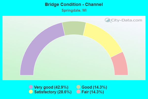
- Bridge Condition - Channel
- 42.9%Very good
- 14.3%Good
- 28.6%Satisfactory
- 14.3%Fair
Find on map >> Show street view
Structure Number: B13002, Location: 1.1M N JCT USH 12 TO E (Lat: 43.048889, Lng: -89.393861), Route carried "on" structure: US 151, Year Built: 1948, Year Reconstructed: 1991, Status: Open, Structure Length: 0.81m (2.66ft), Average Daily Traffic: 24,750 (year 2019), Truck Traffic: 3%, Average Future Daily Traffic: 34,332 (year 2039), Design Load: H 15, Features Intersected: WINGRA CREEK
Minimum Vertical Clearance: 30+ m (98+ ft), Kilometerpoint: 0.000, Lanes on structure: 4, Base Highway Network: Yes, Owner: City or Municipal Highway Agency, Approaching Roadway Width: 22.6m (74.1ft), Skew: 30 degrees, Material/Design: Concrete, Design/Construction: Slab, Number Of Spans In Main Unit: 1, Length of Maximum Span: 7.6m (24.9ft), Curb or Sidewalk Widths: Left: 2.0m (6.6ft), Right: 2.0m (6.6ft), Curb-To-Curb Width: 22.6m (74.1ft), Out-to-Out Width: 32.4m (106.3ft)
Condition: Deck: Satisfactory, Superstructure: Satisfactory, Substructure: Fair, Channel: Very good, Operating Rating: 67.0 metric tons, Method Used To Determine Operating Rating: Load Factor (LF), Inventory Rating: 38.9 metric tons, Method Used To Determine Inventory Rating: Load Factor (LF), Structural Evaluation: Somewhat better than minimum adequacy, Deck Geometry: Superior to present desirable criteria, Waterway Adequacy: Equal to present desirable criteria, Approach Roadway Alignment: Equal to present desirable criteria, Designated Inspection Frequency: Every 24 months, Inspection Date: October 2020, Deck Structure Type: Concrete Cast-file-Place, Wearing Surface/Protective System: Wearing Surface: Monolithic Concrete, Deck Protection: Epoxy Coated Reinforcing
Find on map >> Show street view
Structure Number: B130028, Location: 0.2M S JCT STH 92 (Lat: 42.946056, Lng: -89.657333), Route carried "on" structure: County highway , Year Built: 1950, Status: Open, Structure Length: 2.08m (6.82ft), Average Daily Traffic: 2,189 (year 2019), Average Future Daily Traffic: 2,407 (year 2040), Design Load: H 15, Features Intersected: MT VERNON CREEK, Facility Carried by Structure: CTH G
Minimum Vertical Clearance: 30+ m (98+ ft), Kilometerpoint: 0.000, Lanes on structure: 2, Owner: County Highway Agency, Approaching Roadway Width: 10.4m (34.1ft), Material/Design: Steel, Design/Construction: Stringer/Multi-beam, Number Of Spans In Main Unit: 1, Length of Maximum Span: 20.7m (67.9ft), Curb or Sidewalk Widths: Left: 0.8m (2.6ft), Right: 0.8m (2.6ft), Curb-To-Curb Width: 8.0m (26.2ft), Out-to-Out Width: 11.4m (37.4ft)
Condition: Deck: Poor, Superstructure: Poor, Substructure: Fair, Channel: Satisfactory, Operating Rating: 27.8 metric tons, Method Used To Determine Operating Rating: Load Factor (LF), Inventory Rating: 16.2 metric tons, Method Used To Determine Inventory Rating: Load Factor (LF), Structural Evaluation: Meets minimum limits, Deck Geometry: High priority of corrective action, Waterway Adequacy: Better than present minimum criteria, Approach Roadway Alignment: Equal to present desirable criteria, Length Of Structure Improvement: 2.53m (8.30ft), Designated Inspection Frequency: Every 12 months, Inspection Date: November 2021, Bridge Improvement Cost: $269,000, Roadway Improvement Cost: $26,000, Total Project Cost: $404,000 ( Estimate for 2021), Deck Structure Type: Concrete Cast-file-Place, Wearing Surface/Protective System: Wearing Surface: Low Slump Concrete
Find on map >> Show street view
Structure Number: B130051, Location: 2.9M E JCT CTH P (Lat: 42.988056, Lng: -89.627328), Route carried "on" structure: US 18, Year Built: 1955, Year Reconstructed: 1991, Status: Open, Structure Length: 4.11m (13.48ft), Average Daily Traffic: 9,200 (year 2019), Truck Traffic: 8%, Average Future Daily Traffic: 11,640 (year 2040), Design Load: H 20, Features Intersected: CTH J
Minimum Vertical Clearance: 30+ m (98+ ft), Kilometerpoint: 0.000, Lanes on structure: 2, Lanes under structure: 2, Base Highway Network: Yes, Owner: State Highway Agency, Approaching Roadway Width: 12.2m (40.0ft), Material/Design: Steel continuous, Design/Construction: Stringer/Multi-beam, Number Of Spans In Main Unit: 3, Length of Maximum Span: 15.2m (49.9ft), Curb-To-Curb Width: 12.2m (40.0ft), Out-to-Out Width: 12.9m (42.3ft)
Condition: Deck: Satisfactory, Superstructure: Satisfactory, Substructure: Fair, Operating Rating: 52.3 metric tons, Method Used To Determine Operating Rating: Load Factor (LF), Inventory Rating: 30.8 metric tons, Method Used To Determine Inventory Rating: Load Factor (LF), Structural Evaluation: Somewhat better than minimum adequacy, Deck Geometry: Better than present minimum criteria, Underclear: Better than present minimum criteria, Approach Roadway Alignment: Equal to present desirable criteria, Designated Inspection Frequency: Every 24 months, Inspection Date: April 2021, Deck Structure Type: Concrete Cast-file-Place, Wearing Surface/Protective System: Wearing Surface: Monolithic Concrete, Deck Protection: Epoxy Coated Reinforcing
Find on map >> Show street view
Structure Number: B130109, Location: 1.0M N JCT CTH PD (Lat: 43.024972, Lng: -89.621611), Route carried "on" structure: County highway , Year Built: 1958, Status: Open, Structure Length: 3.12m (10.24ft), Average Daily Traffic: 528 (year 2019), Average Future Daily Traffic: 580 (year 2040), Design Load: H 15, Features Intersected: SUGAR RIVER, Facility Carried by Structure: CTH J
Minimum Vertical Clearance: 30+ m (98+ ft), Kilometerpoint: 0.000, Lanes on structure: 2, Owner: County Highway Agency, Approaching Roadway Width: 9.1m (29.9ft), Material/Design: Steel continuous, Design/Construction: Stringer/Multi-beam, Number Of Spans In Main Unit: 3, Length of Maximum Span: 12.2m (40.0ft), Curb-To-Curb Width: 9.2m (30.2ft), Out-to-Out Width: 9.9m (32.5ft)
Condition: Deck: Poor, Superstructure: Fair, Substructure: Poor, Channel: Satisfactory, Operating Rating: 33.0 metric tons, Method Used To Determine Operating Rating: Load Factor (LF), Inventory Rating: 19.4 metric tons, Method Used To Determine Inventory Rating: Load Factor (LF), Structural Evaluation: Meets minimum limits, Deck Geometry: Equal to present minimum criteria, Waterway Adequacy: Better than present minimum criteria, Approach Roadway Alignment: Equal to present desirable criteria, Length Of Structure Improvement: 3.57m (11.71ft), Designated Inspection Frequency: Every 12 months, Inspection Date: November 2021, Bridge Improvement Cost: $338,000, Roadway Improvement Cost: $33,000, Total Project Cost: $507,000 ( Estimate for 2021), Deck Structure Type: Concrete Cast-file-Place, Wearing Surface/Protective System: Wearing Surface: Low Slump Concrete
Find on map >> Show street view
Structure Number: B130302, Location: 0.8M E JCT CTH JG (Lat: 42.997256, Lng: -89.719944), Route carried "on" structure: US 18, Year Built: 1988, Status: Open, Structure Length: 4.56m (14.96ft), Average Daily Traffic: 8,800 (year 2019), Truck Traffic: 8%, Average Future Daily Traffic: 22,820 (year 2039), Design Load: HS 20, Features Intersected: STH 92
Minimum Vertical Clearance: 30+ m (98+ ft), Kilometerpoint: 0.000, Lanes on structure: 2, Lanes under structure: 2, Base Highway Network: Yes, Owner: State Highway Agency, Approaching Roadway Width: 12.2m (40.0ft), Material/Design: Prestressed concrete continuous, Design/Construction: Stringer/Multi-beam, Number Of Spans In Main Unit: 3, Length of Maximum Span: 17.7m (58.1ft), Curb-To-Curb Width: 12.2m (40.0ft), Out-to-Out Width: 12.9m (42.3ft)
Condition: Deck: Good, Superstructure: Good, Substructure: Fair, Operating Rating: 41.0 metric tons, Method Used To Determine Operating Rating: Load Factor (LF), Inventory Rating: 35.6 metric tons, Method Used To Determine Inventory Rating: Load Factor (LF), Structural Evaluation: Somewhat better than minimum adequacy, Deck Geometry: Better than present minimum criteria, Underclear: Superior to present desirable criteria, Approach Roadway Alignment: Equal to present desirable criteria, Designated Inspection Frequency: Every 24 months, Inspection Date: September 2020, Deck Structure Type: Concrete Cast-file-Place, Wearing Surface/Protective System: Wearing Surface: Monolithic Concrete, Deck Protection: Epoxy Coated Reinforcing
Find on map >> Show street view
Structure Number: B130303, Location: AT JCT USH 18-USH 151 (Lat: 43.004708, Lng: -89.702814), Route carried "on" structure: County highway , Year Built: 1984, Status: Open, Structure Length: 6.46m (21.19ft), Average Daily Traffic: 2,630 (year 2019), Average Future Daily Traffic: 9,900 (year 2040), Design Load: HS 20, Features Intersected: USH 18-USH 151, Facility Carried by Structure: CTH ID
Minimum Vertical Clearance: 30+ m (98+ ft), Kilometerpoint: 0.000, Lanes on structure: 2, Lanes under structure: 4, Owner: State Highway Agency, Approaching Roadway Width: 12.2m (40.0ft), Material/Design: Prestressed concrete continuous, Design/Construction: Stringer/Multi-beam, Number Of Spans In Main Unit: 2, Length of Maximum Span: 32.0m (105.0ft), Curb-To-Curb Width: 12.2m (40.0ft), Out-to-Out Width: 12.9m (42.3ft)
Condition: Deck: Fair, Superstructure: Satisfactory, Substructure: Fair, Operating Rating: 68.6 metric tons, Method Used To Determine Operating Rating: Load Factor (LF), Inventory Rating: 30.8 metric tons, Method Used To Determine Inventory Rating: Load Factor (LF), Structural Evaluation: Somewhat better than minimum adequacy, Deck Geometry: Equal to present minimum criteria, Underclear: Better than present minimum criteria, Approach Roadway Alignment: Equal to present desirable criteria, Designated Inspection Frequency: Every 24 months, Inspection Date: July 2021, Deck Structure Type: Concrete Cast-file-Place, Wearing Surface/Protective System: Wearing Surface: Monolithic Concrete, Deck Protection: Epoxy Coated Reinforcing
Find on map >> Show street view
Structure Number: B130371, Location: 1.0M E JCT USH 12-18 (Lat: 43.047036, Lng: -89.335825), Route carried "on" structure: County highway , Year Built: 1989, Status: Open, Structure Length: 4.16m (13.65ft), Average Daily Traffic: 12,354 (year 2019), Average Future Daily Traffic: 13,589 (year 2039), Design Load: HS 20, Features Intersected: YAHARA RIVER, Facility Carried by Structure: CTH BW S BROADWAY
Minimum Vertical Clearance: 30+ m (98+ ft), Kilometerpoint: 0.000, Lanes on structure: 4, Owner: County Highway Agency, Approaching Roadway Width: 20.7m (67.9ft), Skew: 31 degrees, Material/Design: Prestressed concrete continuous, Design/Construction: Stringer/Multi-beam, Number Of Spans In Main Unit: 3, Length of Maximum Span: 16.5m (54.1ft), Curb or Sidewalk Widths: Left: 0.0m, Right: 1.7m (5.6ft), Curb-To-Curb Width: 17.7m (58.1ft), Out-to-Out Width: 23.9m (78.4ft)
Condition: Deck: Fair, Superstructure: Fair, Substructure: Satisfactory, Channel: Very good, Operating Rating: 63.7 metric tons, Method Used To Determine Operating Rating: Load Factor (LF), Inventory Rating: 35.6 metric tons, Method Used To Determine Inventory Rating: Load Factor (LF), Structural Evaluation: Somewhat better than minimum adequacy, Deck Geometry: Somewhat better than minimum adequacy, Waterway Adequacy: Equal to present desirable criteria, Approach Roadway Alignment: Equal to present desirable criteria, Designated Inspection Frequency: Every 24 months, Underwater Inspection Frequency: Every 60 months, Inspection Date: November 2020, Underwater Inspection Date: October 2018, Deck Structure Type: Concrete Cast-file-Place, Wearing Surface/Protective System: Wearing Surface: Monolithic Concrete, Deck Protection: Epoxy Coated Reinforcing
Find on map >> Show street view
Structure Number: B130377, Location: 3.5M N JCT STH 92 (Lat: 43.004822, Lng: -89.691506), Route carried "on" structure: City street , Year Built: 1991, Status: Open, Structure Length: 6.15m (20.18ft), Average Daily Traffic: 260 (year 2019), Average Future Daily Traffic: 290 (year 2040), Design Load: HS 20, Features Intersected: USH 18-USH 151, Facility Carried by Structure: LRD TOWN HALL ROAD
Minimum Vertical Clearance: 30+ m (98+ ft), Kilometerpoint: 0.000, Lanes on structure: 2, Lanes under structure: 4, Owner: State Highway Agency, Approaching Roadway Width: 7.9m (25.9ft), Material/Design: Prestressed concrete continuous, Design/Construction: Stringer/Multi-beam, Number Of Spans In Main Unit: 2, Length of Maximum Span: 31.7m (104.0ft), Curb-To-Curb Width: 7.9m (25.9ft), Out-to-Out Width: 8.6m (28.2ft)
Condition: Deck: Good, Superstructure: Good, Substructure: Good, Operating Rating: 73.0 metric tons, Method Used To Determine Operating Rating: Load Factor (LF), Inventory Rating: 35.6 metric tons, Method Used To Determine Inventory Rating: Load Factor (LF), Structural Evaluation: Better than present minimum criteria, Deck Geometry: Somewhat better than minimum adequacy, Underclear: Better than present minimum criteria, Approach Roadway Alignment: Equal to present desirable criteria, Designated Inspection Frequency: Every 48 months, Inspection Date: August 2021, Deck Structure Type: Concrete Cast-file-Place, Wearing Surface/Protective System: Wearing Surface: Monolithic Concrete, Deck Protection: Epoxy Coated Reinforcing
Find on map >> Show street view
Structure Number: B130378, Location: 0.3M S JCT HALLS RD (Lat: 43.003725, Lng: -89.680822), Route carried "on" structure: City street , Year Built: 1991, Status: Open, Structure Length: 6.03m (19.78ft), Average Daily Traffic: 90 (year 2019), Average Future Daily Traffic: 140 (year 2039), Design Load: HS 20, Features Intersected: USH 18-USH 151, Facility Carried by Structure: LRD LUNDE LANE
Minimum Vertical Clearance: 30+ m (98+ ft), Kilometerpoint: 0.000, Lanes on structure: 2, Lanes under structure: 4, Owner: State Highway Agency, Approaching Roadway Width: 7.9m (25.9ft), Material/Design: Prestressed concrete continuous, Design/Construction: Stringer/Multi-beam, Number Of Spans In Main Unit: 2, Length of Maximum Span: 31.1m (102.0ft), Curb-To-Curb Width: 7.9m (25.9ft), Out-to-Out Width: 8.6m (28.2ft)
Condition: Deck: Good, Superstructure: Good, Substructure: Good, Operating Rating: 62.1 metric tons, Method Used To Determine Operating Rating: Load Factor (LF), Inventory Rating: 30.8 metric tons, Method Used To Determine Inventory Rating: Load Factor (LF), Structural Evaluation: Better than present minimum criteria, Deck Geometry: Equal to present minimum criteria, Underclear: Better than present minimum criteria, Approach Roadway Alignment: Equal to present desirable criteria, Designated Inspection Frequency: Every 24 months, Inspection Date: April 2020, Deck Structure Type: Concrete Cast-file-Place, Wearing Surface/Protective System: Wearing Surface: Monolithic Concrete, Deck Protection: Epoxy Coated Reinforcing
Find on map >> Show street view
Structure Number: B130379, Location: 2.4M W JCT CTH J TO S (Lat: 42.999356, Lng: -89.668469), Route carried "on" structure: County highway , Year Built: 1991, Status: Open, Structure Length: 7.17m (23.52ft), Average Daily Traffic: 1,860 (year 2019), Average Future Daily Traffic: 3,430 (year 2040), Design Load: HS 20, Features Intersected: USH 18-USH 151, Facility Carried by Structure: CTH PD
Minimum Vertical Clearance: 30+ m (98+ ft), Kilometerpoint: 0.000, Lanes on structure: 2, Lanes under structure: 4, Owner: State Highway Agency, Approaching Roadway Width: 11.0m (36.1ft), Skew: 3 degrees, Material/Design: Steel continuous, Design/Construction: Stringer/Multi-beam, Number Of Spans In Main Unit: 2, Length of Maximum Span: 34.9m (114.5ft), Curb-To-Curb Width: 11.0m (36.1ft), Out-to-Out Width: 11.6m (38.1ft)
Condition: Deck: Good, Superstructure: Good, Substructure: Good, Operating Rating: 68.6 metric tons, Method Used To Determine Operating Rating: Load Factor (LF), Inventory Rating: 40.5 metric tons, Method Used To Determine Inventory Rating: Load Factor (LF), Structural Evaluation: Better than present minimum criteria, Deck Geometry: Equal to present minimum criteria, Underclear: Better than present minimum criteria, Approach Roadway Alignment: Equal to present desirable criteria, Designated Inspection Frequency: Every 48 months, Inspection Date: August 2021, Deck Structure Type: Concrete Cast-file-Place, Wearing Surface/Protective System: Wearing Surface: Monolithic Concrete, Deck Protection: Epoxy Coated Reinforcing
Find on map >> Show street view
Structure Number: B13056, Location: 0.25M W JCT TWIN VALLEY R (Lat: 43.089231, Lng: -89.586256), Route carried "on" structure: City street , Year Built: 2004, Status: Open, Structure Length: 0.78m (2.56ft), Average Daily Traffic: 20 (year 2019), Truck Traffic: 10%, Average Future Daily Traffic: 21 (year 2039), Design Load: HS 20, Features Intersected: BR BLACK EARTH CREEK, Facility Carried by Structure: LRD LOW RD (DEAD E
Minimum Vertical Clearance: 30+ m (98+ ft), Kilometerpoint: 0.000, Lanes on structure: 2, Owner: Town or Township Highway Agency, Approaching Roadway Width: 7.9m (25.9ft), Skew: 3 degrees, Material/Design: Concrete, Design/Construction: Culvert, Number Of Spans In Main Unit: 2, Length of Maximum Span: 2.7m (8.9ft)
Condition: Channel: Very good, Culverts: Very good, Operating Rating: 53.9 metric tons, Method Used To Determine Operating Rating: Field evaluation and documented engineering judgment, Inventory Rating: 32.4 metric tons, Method Used To Determine Inventory Rating: Field evaluation and documented engineering judgment, Structural Evaluation: Equal to present desirable criteria, Waterway Adequacy: Equal to present minimum criteria, Approach Roadway Alignment: Equal to present desirable criteria, Designated Inspection Frequency: Every 48 months, Inspection Date: September 2020, Deck Structure Type: Concrete Cast-file-Place, Wearing Surface/Protective System: Wearing Surface: Bituminous
Find on map >> Show street view
Structure Number: B130567, Location: AT BR. SUGAR RIVER (Lat: 42.972639, Lng: -89.604139), Route carried "on" structure: City street , Year Built: 2003, Status: Open, Structure Length: 0.93m (3.05ft), Average Daily Traffic: 106 (year 2019), Truck Traffic: 5%, Average Future Daily Traffic: 116 (year 2039), Design Load: HS 20, Features Intersected: BR SUGAR R, Facility Carried by Structure: LRD SPRING ROSE RD
Minimum Vertical Clearance: 30+ m (98+ ft), Kilometerpoint: 0.000, Lanes on structure: 2, Owner: Town or Township Highway Agency, Approaching Roadway Width: 7.3m (24.0ft), Material/Design: Concrete, Design/Construction: Slab, Number Of Spans In Main Unit: 1, Length of Maximum Span: 8.5m (27.9ft), Curb-To-Curb Width: 7.3m (24.0ft), Out-to-Out Width: 7.9m (25.9ft)
Condition: Deck: Good, Superstructure: Good, Substructure: Very good, Channel: Good, Operating Rating: 68.6 metric tons, Method Used To Determine Operating Rating: Load Factor (LF), Inventory Rating: 40.5 metric tons, Method Used To Determine Inventory Rating: Load Factor (LF), Structural Evaluation: Better than present minimum criteria, Deck Geometry: Somewhat better than minimum adequacy, Waterway Adequacy: Equal to present minimum criteria, Approach Roadway Alignment: Equal to present desirable criteria, Designated Inspection Frequency: Every 48 months, Inspection Date: September 2020, Deck Structure Type: Concrete Cast-file-Place, Wearing Surface/Protective System: Wearing Surface: Monolithic Concrete, Deck Protection: Epoxy Coated Reinforcing
Find on map >> Show street view
Structure Number: B130568, Location: 0.7M E JCT OF CTH J (Lat: 43.016861, Lng: -89.610000), Route carried "on" structure: City street , Year Built: 2004, Status: Open, Structure Length: 1.42m (4.66ft), Average Daily Traffic: 105 (year 2019), Truck Traffic: 5%, Average Future Daily Traffic: 115 (year 2039), Design Load: HS 20, Features Intersected: SUGAR RIVER, Facility Carried by Structure: LRD PAULSON RD
Minimum Vertical Clearance: 30+ m (98+ ft), Kilometerpoint: 0.000, Lanes on structure: 2, Owner: Town or Township Highway Agency, Approaching Roadway Width: 7.3m (24.0ft), Material/Design: Concrete, Design/Construction: Slab, Number Of Spans In Main Unit: 1, Length of Maximum Span: 13.4m (44.0ft), Curb-To-Curb Width: 7.3m (24.0ft), Out-to-Out Width: 7.9m (25.9ft)
Condition: Deck: Good, Superstructure: Good, Substructure: Very good, Channel: Fair, Operating Rating: 63.7 metric tons, Method Used To Determine Operating Rating: Load Factor (LF), Inventory Rating: 37.3 metric tons, Method Used To Determine Inventory Rating: Load Factor (LF), Structural Evaluation: Better than present minimum criteria, Deck Geometry: Somewhat better than minimum adequacy, Waterway Adequacy: Equal to present minimum criteria, Approach Roadway Alignment: Equal to present minimum criteria, Designated Inspection Frequency: Every 24 months, Inspection Date: September 2020, Deck Structure Type: Concrete Cast-file-Place, Wearing Surface/Protective System: Wearing Surface: Monolithic Concrete, Deck Protection: Epoxy Coated Reinforcing
Find on map >> Show street view
Structure Number: B130051, Location: 1.6M N JCT CTH G (Lat: 42.988056, Lng: -89.627328), Route carried "under" structure: County highway , Year Built: 1955, Structure Length: 0. m, Average Daily Traffic: 880 (year 2019), Features Intersected: CTH J, Facility Carried by Structure: USH 18 EB-USH 151
Minimum Vertical Clearance: 4.80m (15.75ft), Kilometerpoint: 0.000, Lanes on structure: 2, Lanes under structure: 2, Material/Design: Steel continuous, Design/Construction: Stringer/Multi-beam, Length of Maximum Span: 15.2m (49.9ft)
Find on map >> Show street view
Structure Number: B130301, Location: 1.5M E JCT STH 78 (Lat: 42.997708, Lng: -89.719647), Route carried "under" structure: State highway 92, Year Built: 1984, Structure Length: 0. m, Average Daily Traffic: 1,600 (year 2018), Truck Traffic: 7%, Features Intersected: STH 92, Facility Carried by Structure: USH 18 WB-USH 151
Minimum Vertical Clearance: 5.79m (19.00ft), Kilometerpoint: 0.000, Lanes on structure: 2, Lanes under structure: 2, Material/Design: Prestressed concrete continuous, Design/Construction: Stringer/Multi-beam, Length of Maximum Span: 17.7m (58.1ft)
Find on map >> Show street view
Structure Number: B130302, Location: 1.5M E JCT STH 78 (Lat: 42.997256, Lng: -89.719944), Route carried "under" structure: State highway 92, Year Built: 1988, Structure Length: 0. m, Average Daily Traffic: 1,300 (year 2019), Truck Traffic: 7%, Features Intersected: STH 92, Facility Carried by Structure: USH 18 EB-USH 151
Minimum Vertical Clearance: 6.63m (21.75ft), Kilometerpoint: 0.000, Lanes on structure: 2, Lanes under structure: 2, Material/Design: Prestressed concrete continuous, Design/Construction: Stringer/Multi-beam, Length of Maximum Span: 17.7m (58.1ft)
Find on map >> Show street view
Structure Number: B130303, Location: 0.9M E JCT STH 92 (Lat: 43.004708, Lng: -89.702814), Route carried "under" structure: US 18, Year Built: 1984, Structure Length: 0. m, Average Daily Traffic: 16,430 (year 2019), Truck Traffic: 8%, Features Intersected: USH 18-USH 151, Facility Carried by Structure: CTH ID
Minimum Vertical Clearance: 5.20m (17.06ft), Kilometerpoint: 0.000, Lanes on structure: 2, Lanes under structure: 4, Material/Design: Prestressed concrete continuous, Design/Construction: Stringer/Multi-beam, Length of Maximum Span: 32.0m (105.0ft)
Find on map >> Show street view
Structure Number: B130377, Location: 1.6M E JCT STH 92 (Lat: 43.004822, Lng: -89.691506), Route carried "under" structure: US 18, Year Built: 1991, Structure Length: 0. m, Average Daily Traffic: 25,000 (year 2018), Truck Traffic: 8%, Features Intersected: USH 18-USH 151, Facility Carried by Structure: LRD TOWN HALL ROAD
Minimum Vertical Clearance: 5.11m (16.77ft), Kilometerpoint: 0.000, Lanes on structure: 2, Lanes under structure: 4, Material/Design: Prestressed concrete continuous, Design/Construction: Stringer/Multi-beam, Length of Maximum Span: 31.7m (104.0ft)
Find on map >> Show street view
Structure Number: B130378, Location: 2.1M E JCT STH 92 (Lat: 43.003725, Lng: -89.680822), Route carried "under" structure: US 18, Year Built: 1991, Structure Length: 0. m, Average Daily Traffic: 25,000 (year 2018), Truck Traffic: 8%, Features Intersected: USH 18-USH 151, Facility Carried by Structure: LRD LUNDE LANE
Minimum Vertical Clearance: 5.07m (16.63ft), Kilometerpoint: 0.000, Lanes on structure: 2, Lanes under structure: 4, Material/Design: Prestressed concrete continuous, Design/Construction: Stringer/Multi-beam, Length of Maximum Span: 31.1m (102.0ft)
Find on map >> Show street view
Structure Number: B130379, Location: 0.4M E JCT CTH P TO N (Lat: 42.999356, Lng: -89.668469), Route carried "under" structure: US 18, Year Built: 1991, Structure Length: 0. m, Average Daily Traffic: 19,400 (year 2019), Truck Traffic: 8%, Features Intersected: USH 18-USH 151, Facility Carried by Structure: CTH PD
Minimum Vertical Clearance: 5.08m (16.67ft), Kilometerpoint: 0.000, Lanes on structure: 2, Lanes under structure: 4, Material/Design: Steel continuous, Design/Construction: Stringer/Multi-beam, Length of Maximum Span: 34.9m (114.5ft)
Find on map >> Show street view
Structure Number: B13038, Location: 1.7M N JCT CTH G (Lat: 42.988386, Lng: -89.626839), Route carried "under" structure: County highway , Year Built: 1991, Structure Length: 0. m, Average Daily Traffic: 880 (year 2019), Features Intersected: CTH J, Facility Carried by Structure: USH 18 WB-USH 151
Minimum Vertical Clearance: 4.48m (14.70ft), Kilometerpoint: 0.000, Lanes on structure: 2, Lanes under structure: 2, Material/Design: Steel continuous, Design/Construction: Stringer/Multi-beam, Length of Maximum Span: 15.2m (49.9ft)