Bridge Statistics for St. Charles, Illinois (IL)
Condition, Traffic, Stress, Structural Evaluation, Project Costs
- National Bridge Inventory (NBI) Statistics
- 15Number of bridges
- 190ft / 58.2mTotal length
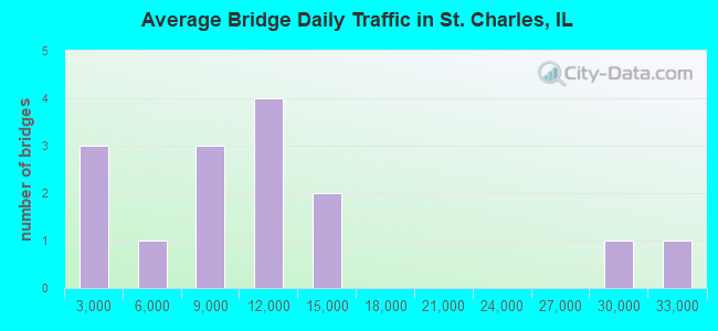
- 157,575Total average daily traffic
- 8,012Total average daily truck traffic
- National Bridge Inventory (NBI) Registered Bridges for St. Charles
- No street view available for this location

- New bridges - historical statistics
- 21950-1959
- 41960-1969
- 21980-1989
- 21990-1999
- 12000-2009
- 42010-2019
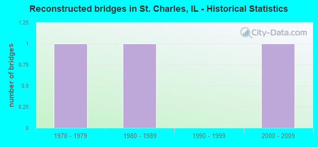
- Reconstructed bridges - Historical Statistics
- 11970-1979
- 11980-1989
- 01990-1999
- 12000-2009
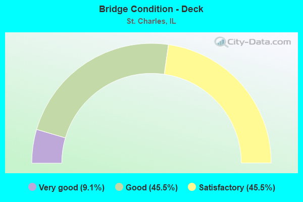
- Bridge Condition - Deck
- 9.1%Very good
- 45.5%Good
- 45.5%Satisfactory
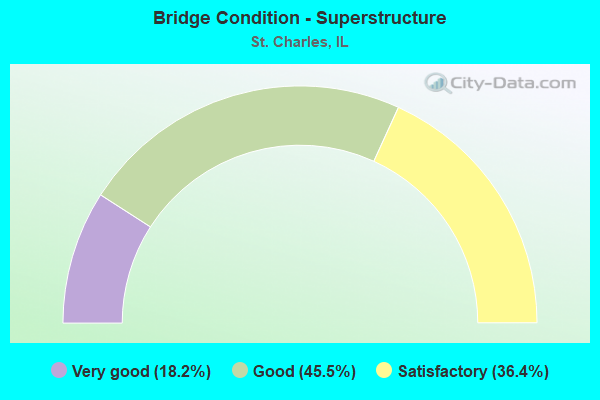
- Bridge Condition - Superstructure
- 18.2%Very good
- 45.5%Good
- 36.4%Satisfactory
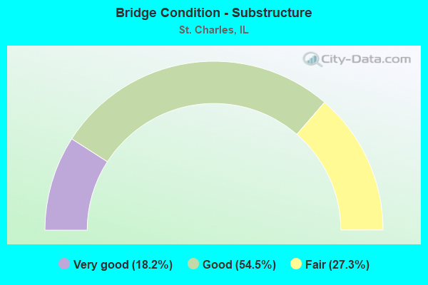
- Bridge Condition - Substructure
- 18.2%Very good
- 54.5%Good
- 27.3%Fair
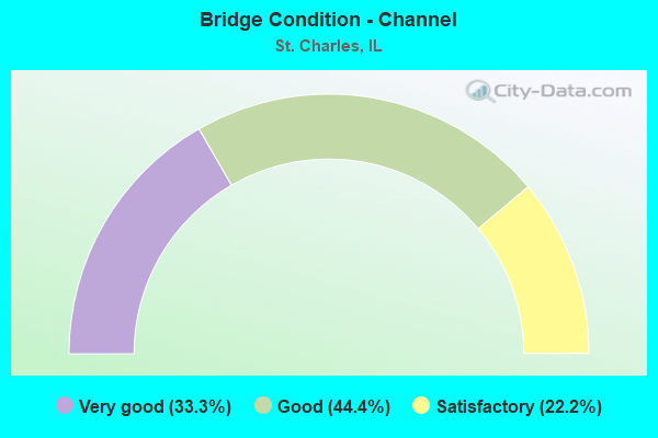
- Bridge Condition - Channel
- 33.3%Very good
- 44.4%Good
- 22.2%Satisfactory
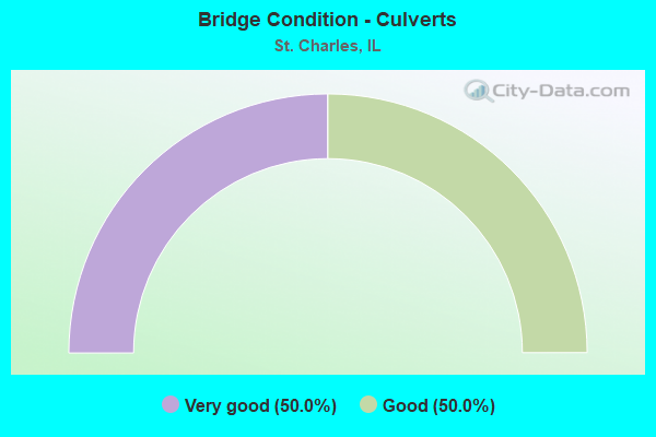
- Bridge Condition - Culverts
- 50.0%Very good
- 50.0%Good
Find on map >> Show street view
Structure Number: 450045, Location: 2.2 M N OF IL 64 (Lat: 41.944961, Lng: -88.306311), Route carried "on" structure: State highway 25, Year Built: 1967, Year Reconstructed: 2008, Status: Open, Structure Length: 1.99m (6.53ft), Average Daily Traffic: 8,150 (year 2021), Truck Traffic: 3%, Average Future Daily Traffic: 12,824 (year 2032), Design Load: HS 20, Features Intersected: NORTON CREEK
Minimum Vertical Clearance: 30+ m (98+ ft), Kilometerpoint: 31.462, Lanes on structure: 2, Base Highway Network: Yes, Owner: State Highway Agency, Approaching Roadway Width: 12.2m (40.0ft), Material/Design: Prestressed concrete, Design/Construction: Box Beam or Girders - Multiple, Number Of Spans In Main Unit: 2, Length of Maximum Span: 9.4m (30.8ft), Curb-To-Curb Width: 13.0m (42.7ft), Out-to-Out Width: 14.0m (45.9ft)
Condition: Deck: Good, Superstructure: Good, Substructure: Good, Channel: Satisfactory, Operating Rating: 85.9 metric tons, Method Used To Determine Operating Rating: Load Factor (LF) rating reported by rating factor (RF) method using MS18 loading, Inventory Rating: 51.5 metric tons, Method Used To Determine Inventory Rating: Load Factor (LF) rating reported by rating factor (RF) method using MS18 loading, Structural Evaluation: Better than present minimum criteria, Deck Geometry: Somewhat better than minimum adequacy, Waterway Adequacy: Equal to present minimum criteria, Approach Roadway Alignment: Equal to present desirable criteria, Designated Inspection Frequency: Every 48 months, Inspection Date: August 2020, Deck Structure Type: Concrete Cast-file-Place, Wearing Surface/Protective System: Wearing Surface: Integral Concrete, Deck Protection: Epoxy Coated Reinforcing
Find on map >> Show street view
Structure Number: 450061, Location: 0.1 M N OF IL 64 (Lat: 41.916764, Lng: -88.309369), Route carried "on" structure: State highway 25, Year Built: 1969, Status: Open, Structure Length: 3.98m (13.06ft), Average Daily Traffic: 8,150 (year 2021), Truck Traffic: 3%, Average Future Daily Traffic: 12,824 (year 2032), Design Load: HS 20, Features Intersected: ABANDONED RR - UP
Minimum Vertical Clearance: 30+ m (98+ ft), Kilometerpoint: 28.275, Lanes on structure: 2, Base Highway Network: Yes, Owner: State Highway Agency, Approaching Roadway Width: 10.4m (34.1ft), Skew: 1 degrees, Material/Design: Concrete continuous, Design/Construction: Slab, Number Of Spans In Main Unit: 3, Length of Maximum Span: 15.2m (49.9ft), Curb or Sidewalk Widths: Left: 1.5m (4.9ft), Right: 1.5m (4.9ft), Curb-To-Curb Width: 10.4m (34.1ft), Out-to-Out Width: 14.0m (45.9ft)
Condition: Deck: Good, Superstructure: Good, Substructure: Good, Operating Rating: 66.7 metric tons, Method Used To Determine Operating Rating: Load Factor (LF) rating reported by rating factor (RF) method using MS18 loading, Inventory Rating: 39.9 metric tons, Method Used To Determine Inventory Rating: Load Factor (LF) rating reported by rating factor (RF) method using MS18 loading, Structural Evaluation: Better than present minimum criteria, Deck Geometry: Meets minimum limits, Underclear: Equal to present minimum criteria, Approach Roadway Alignment: Equal to present desirable criteria, Designated Inspection Frequency: Every 24 months, Inspection Date: September 2020, Deck Structure Type: Concrete Cast-file-Place, Wearing Surface/Protective System: Wearing Surface: Latex Concrete, Membrane: Built-up
Find on map >> Show street view
Structure Number: 450269, Location: 0.25 M W OF PECK RD (Lat: 41.902878, Lng: -88.364347), Route carried "on" structure: State highway 38, Year Built: 2012, Status: Open, Structure Length: 0.75m (2.46ft), Average Daily Traffic: 11,500 (year 2021), Truck Traffic: 12%, Average Future Daily Traffic: 15,057 (year 2032), Features Intersected: DITCH
Minimum Vertical Clearance: 30+ m (98+ ft), Kilometerpoint: 101.676, Lanes on structure: 2, Base Highway Network: Yes, Owner: State Highway Agency, Approaching Roadway Width: 7.3m (24.0ft), Material/Design: Concrete, Design/Construction: Culvert, Number Of Spans In Main Unit: 2, Length of Maximum Span: 3.0m (9.8ft)
Condition: Channel: Very good, Culverts: Good, Operating Rating: 54.1 metric tons, Method Used To Determine Operating Rating: Field evaluation and documented engineering judgment, Inventory Rating: 32.4 metric tons, Method Used To Determine Inventory Rating: Field evaluation and documented engineering judgment, Structural Evaluation: Better than present minimum criteria, Waterway Adequacy: Better than present minimum criteria, Approach Roadway Alignment: Equal to present desirable criteria, Designated Inspection Frequency: Every 48 months, Inspection Date: April 2018
Find on map >> Show street view
Structure Number: 450333, Location: 1.1 M N OF IL 64 (Lat: 41.928731, Lng: -88.321739), Route carried "on" structure: State highway 31, Year Built: 2016, Status: Open, Structure Length: 2.87m (9.42ft), Average Daily Traffic: 12,400 (year 2021), Truck Traffic: 5%, Average Future Daily Traffic: 13,400 (year 2041), Design Load: HS 25 or greater, Features Intersected: FERSON CREEK
Minimum Vertical Clearance: 30+ m (98+ ft), Kilometerpoint: 29.482, Lanes on structure: 2, Base Highway Network: Yes, Owner: State Highway Agency, Approaching Roadway Width: 15.8m (51.8ft), Material/Design: Steel, Design/Construction: Stringer/Multi-beam, Number Of Spans In Main Unit: 1, Length of Maximum Span: 27.7m (90.9ft), Curb-To-Curb Width: 15.8m (51.8ft), Out-to-Out Width: 16.8m (55.1ft)
Condition: Deck: Very good, Superstructure: Good, Substructure: Very good, Channel: Good, Operating Rating: 62.2 metric tons, Method Used To Determine Operating Rating: Load and Resistance Factor Rating (LRFR) rating reported by rating factor(RF) method using HL-93 loadings, Inventory Rating: 47.6 metric tons, Method Used To Determine Inventory Rating: Load and Resistance Factor Rating (LRFR) rating reported by rating factor(RF) method using HL-93 loadings, Structural Evaluation: Better than present minimum criteria, Deck Geometry: Superior to present desirable criteria, Waterway Adequacy: Equal to present desirable criteria, Approach Roadway Alignment: Equal to present desirable criteria, Designated Inspection Frequency: Every 48 months, Inspection Date: September 2018, Deck Structure Type: Concrete Cast-file-Place, Wearing Surface/Protective System: Deck Protection: Epoxy Coated Reinforcing
Find on map >> Show street view
Structure Number: 450334, Location: 1.6 M N of IL 64 (Lat: 41.929186, Lng: -88.321731), Route carried "on" structure: State highway 31, Year Built: 2016, Status: Open, Structure Length: 0.79m (2.59ft), Average Daily Traffic: 12,400 (year 2021), Truck Traffic: 5%, Average Future Daily Traffic: 13,400 (year 2041), Design Load: HS 25 or greater, Features Intersected: FERSON CREEK OVERFLO
Minimum Vertical Clearance: 30+ m (98+ ft), Kilometerpoint: 29.531, Lanes on structure: 2, Base Highway Network: Yes, Owner: State Highway Agency, Approaching Roadway Width: 15.8m (51.8ft), Material/Design: Concrete continuous, Design/Construction: Culvert, Number Of Spans In Main Unit: 2, Length of Maximum Span: 3.7m (12.1ft), Curb-To-Curb Width: 15.8m (51.8ft)
Condition: Channel: Very good, Culverts: Very good, Operating Rating: 52.8 metric tons, Method Used To Determine Operating Rating: Load and Resistance Factor Rating (LRFR) rating reported by rating factor(RF) method using HL-93 loadings, Inventory Rating: 40.8 metric tons, Method Used To Determine Inventory Rating: Load and Resistance Factor Rating (LRFR) rating reported by rating factor(RF) method using HL-93 loadings, Structural Evaluation: Equal to present desirable criteria, Deck Geometry: Superior to present desirable criteria, Waterway Adequacy: Equal to present desirable criteria, Approach Roadway Alignment: Equal to present desirable criteria, Designated Inspection Frequency: Every 48 months, Inspection Date: September 2018, Deck Structure Type: Other
Find on map >> Show street view
Structure Number: 452018, Location: 0.2 M W OF IL 25 (Lat: 41.913369, Lng: -88.315531), Route carried "on" structure: State highway 64, Year Built: 1997, Status: Open, Structure Length: 8.42m (27.62ft), Average Daily Traffic: 29,100 (year 2021), Truck Traffic: 5%, Average Future Daily Traffic: 40,322 (year 2032), Design Load: H 20, Features Intersected: FOX RIVER
Minimum Vertical Clearance: 30+ m (98+ ft), Kilometerpoint: 165.275, Lanes on structure: 4, Base Highway Network: Yes, Owner: State Highway Agency, Approaching Roadway Width: 13.2m (43.3ft), Material/Design: Prestressed concrete continuous, Design/Construction: Stringer/Multi-beam, Number Of Spans In Main Unit: 4, Length of Maximum Span: 21.3m (69.9ft), Curb or Sidewalk Widths: Left: 2.9m (9.5ft), Right: 2.9m (9.5ft), Curb-To-Curb Width: 13.2m (43.3ft), Out-to-Out Width: 25.1m (82.3ft)
Condition: Deck: Good, Superstructure: Good, Substructure: Fair, Channel: Very good, Operating Rating: 58.3 metric tons, Method Used To Determine Operating Rating: Load Factor (LF) rating reported by rating factor (RF) method using MS18 loading, Inventory Rating: 36.0 metric tons, Method Used To Determine Inventory Rating: Load Factor (LF) rating reported by rating factor (RF) method using MS18 loading, Structural Evaluation: Somewhat better than minimum adequacy, Deck Geometry: High priority of replacement, Waterway Adequacy: Superior to present desirable criteria, Approach Roadway Alignment: Equal to present desirable criteria, Designated Inspection Frequency: Every 24 months, Other Special Inspection Frequency: Every 24 months, Inspection Date: September 2020, Other Special Inspection Date: September 2020, Deck Structure Type: Concrete Cast-file-Place, Wearing Surface/Protective System: Wearing Surface: Epoxy Overlay, Deck Protection: Epoxy Coated Reinforcing
Find on map >> Show street view
Structure Number: 453027, Location: 0.2 MI S of Crane Rd (Lat: 41.933572, Lng: -88.341219), Route carried "on" structure: Other road , Year Built: 1955, Year Reconstructed: 1983, Status: Open, Structure Length: 4.93m (16.17ft), Average Daily Traffic: 30,900 (year 2018), Truck Traffic: 5%, Average Future Daily Traffic: 19,012 (year 2032), Design Load: HS 20, Features Intersected: FERSON CREEK, Facility Carried by Structure: RANDALL ROAD
Minimum Vertical Clearance: 30+ m (98+ ft), Kilometerpoint: 24.671, Lanes on structure: 2, Base Highway Network: Yes, Owner: County Highway Agency, Approaching Roadway Width: 21.0m (68.9ft), Material/Design: Steel continuous, Design/Construction: Stringer/Multi-beam, Number Of Spans In Main Unit: 3, Length of Maximum Span: 17.7m (58.1ft), Curb-To-Curb Width: 20.7m (67.9ft), Out-to-Out Width: 21.7m (71.2ft)
Condition: Deck: Satisfactory, Superstructure: Satisfactory, Substructure: Good, Channel: Good, Operating Rating: 50.2 metric tons, Method Used To Determine Operating Rating: Load Factor (LF) rating reported by rating factor (RF) method using MS18 loading, Inventory Rating: 30.1 metric tons, Method Used To Determine Inventory Rating: Load Factor (LF) rating reported by rating factor (RF) method using MS18 loading, Structural Evaluation: Equal to present minimum criteria, Deck Geometry: Superior to present desirable criteria, Waterway Adequacy: Superior to present desirable criteria, Approach Roadway Alignment: Equal to present desirable criteria, Designated Inspection Frequency: Every 24 months, Inspection Date: May 2020, Deck Structure Type: Concrete Cast-file-Place, Wearing Surface/Protective System: Deck Protection: Epoxy Coated Reinforcing
Find on map >> Show street view
Structure Number: 453068, Location: 1.0 MI E LAFOX (Lat: 41.892322, Lng: -88.385419), Route carried "on" structure: County highway , Year Built: 1960, Status: Open, Structure Length: 1.17m (3.84ft), Average Daily Traffic: 375 (year 2018), Truck Traffic: 5%, Average Future Daily Traffic: 351 (year 2032), Design Load: HS 15, Features Intersected: MILL CREEK, Facility Carried by Structure: BRUNDIGE ROAD
Minimum Vertical Clearance: 30+ m (98+ ft), Kilometerpoint: 1.352, Lanes on structure: 2, Owner: Town or Township Highway Agency, Approaching Roadway Width: 5.5m (18.0ft), Material/Design: Concrete, Design/Construction: Tee Beam, Number Of Spans In Main Unit: 1, Length of Maximum Span: 11.4m (37.4ft), Curb-To-Curb Width: 7.3m (24.0ft), Out-to-Out Width: 8.6m (28.2ft)
Condition: Deck: Satisfactory, Superstructure: Satisfactory, Substructure: Good, Channel: Satisfactory, Operating Rating: 43.1 metric tons, Method Used To Determine Operating Rating: Load Factor (LF) rating reported by rating factor (RF) method using MS18 loading, Inventory Rating: 25.9 metric tons, Method Used To Determine Inventory Rating: Load Factor (LF) rating reported by rating factor (RF) method using MS18 loading, Structural Evaluation: Equal to present minimum criteria, Deck Geometry: Somewhat better than minimum adequacy, Waterway Adequacy: Equal to present desirable criteria, Approach Roadway Alignment: Equal to present desirable criteria, Designated Inspection Frequency: Every 24 months, Inspection Date: May 2021, Deck Structure Type: Concrete Cast-file-Place
Find on map >> Show street view
Structure Number: 456019, Location: 0.12 M W of IL 25 (Lat: 41.949494, Lng: -88.308769), Route carried "on" structure: Other road , Year Built: 2011, Status: Open, Structure Length: 3.05m (10.01ft), Average Daily Traffic: 11,400 (year 2018), Truck Traffic: 4%, Average Future Daily Traffic: 4,847 (year 2037), Design Load: HS 25 or greater, Features Intersected: FOX RIVER BIKE TRAIL, Facility Carried by Structure: RED GATE ROAD
Minimum Vertical Clearance: 30+ m (98+ ft), Kilometerpoint: 3.363, Lanes on structure: 2, Base Highway Network: Yes, Owner: City or Municipal Highway Agency, Approaching Roadway Width: 9.8m (32.2ft), Material/Design: Prestressed concrete, Design/Construction: Stringer/Multi-beam, Number Of Spans In Main Unit: 1, Length of Maximum Span: 29.7m (97.4ft), Curb-To-Curb Width: 12.9m (42.3ft), Out-to-Out Width: 13.9m (45.6ft)
Condition: Deck: Satisfactory, Superstructure: Very good, Substructure: Very good, Operating Rating: 42.1 metric tons, Method Used To Determine Operating Rating: Assigned ratings based on Load and Resistance Factor Design (LRFD) reported by rating factor (RF) using HL93 loadings, Inventory Rating: 32.4 metric tons, Method Used To Determine Inventory Rating: Assigned ratings based on Load and Resistance Factor Design (LRFD) reported by rating factor (RF) using HL93 loadings, Structural Evaluation: Equal to present desirable criteria, Deck Geometry: Somewhat better than minimum adequacy, Approach Roadway Alignment: Equal to present desirable criteria, Designated Inspection Frequency: Every 48 months, Inspection Date: May 2021, Deck Structure Type: Concrete Cast-file-Place, Wearing Surface/Protective System: Deck Protection: Epoxy Coated Reinforcing
Find on map >> Show street view
Structure Number: 456851, Location: 0.2 MI S ILL 64 (Lat: 41.912581, Lng: -88.310967), Route carried "on" structure: Other road , Year Built: 1958, Year Reconstructed: 1987, Status: Open, Structure Length: 6.95m (22.80ft), Average Daily Traffic: 3,050 (year 2018), Truck Traffic: 8%, Average Future Daily Traffic: 6,508 (year 2032), Design Load: HS 20, Features Intersected: FOX RIVER, Facility Carried by Structure: ILLINOIS STREET
Minimum Vertical Clearance: 30+ m (98+ ft), Kilometerpoint: 0.724, Lanes on structure: 4, Owner: City or Municipal Highway Agency, Approaching Roadway Width: 17.1m (56.1ft), Skew: 20 degrees, Material/Design: Steel, Design/Construction: Stringer/Multi-beam, Number Of Spans In Main Unit: 3, Length of Maximum Span: 22.9m (75.1ft), Curb or Sidewalk Widths: Left: 1.4m (4.6ft), Right: 1.4m (4.6ft), Curb-To-Curb Width: 17.1m (56.1ft), Out-to-Out Width: 20.8m (68.2ft)
Condition: Deck: Satisfactory, Superstructure: Satisfactory, Substructure: Good, Channel: Good, Operating Rating: 47.3 metric tons, Method Used To Determine Operating Rating: Allowable Stress (AS) rating reported by rating factor (RF) method using MS18 loading, Inventory Rating: 24.9 metric tons, Method Used To Determine Inventory Rating: Allowable Stress (AS) rating reported by rating factor (RF) method using MS18 loading, Structural Evaluation: Equal to present minimum criteria, Deck Geometry: Somewhat better than minimum adequacy, Waterway Adequacy: Equal to present desirable criteria, Approach Roadway Alignment: Better than present minimum criteria, Designated Inspection Frequency: Every 24 months, Inspection Date: May 2020, Deck Structure Type: Concrete Cast-file-Place, Wearing Surface/Protective System: Deck Protection: Epoxy Coated Reinforcing
Find on map >> Show street view
Structure Number: 456853, Location: 0.3M N OF IL.64 (Lat: 41.916842, Lng: -88.311344), Route carried "on" structure: City street , Year Built: 1985, Status: Open, Structure Length: 3.98m (13.06ft), Average Daily Traffic: 400 (year 2020), Average Future Daily Traffic: 267 (year 2032), Design Load: HS 20, Features Intersected: UPRR (ABANDONED), Facility Carried by Structure: 3RD. AVENUE
Minimum Vertical Clearance: 30+ m (98+ ft), Kilometerpoint: 1.110, Lanes on structure: 2, Owner: City or Municipal Highway Agency, Approaching Roadway Width: 8.5m (27.9ft), Material/Design: Concrete continuous, Design/Construction: Slab, Number Of Spans In Main Unit: 3, Length of Maximum Span: 15.2m (49.9ft), Curb or Sidewalk Widths: Left: 1.8m (5.9ft), Right: 1.8m (5.9ft), Curb-To-Curb Width: 8.5m (27.9ft), Out-to-Out Width: 13.2m (43.3ft)
Condition: Deck: Satisfactory, Superstructure: Satisfactory, Substructure: Fair, Operating Rating: 44.4 metric tons, Method Used To Determine Operating Rating: Assigned rating based on Load Factor Design (LFD) reported by rating factor (RF) using MS18 loading, Inventory Rating: 32.4 metric tons, Method Used To Determine Inventory Rating: Assigned rating based on Load Factor Design (LFD) reported by rating factor (RF) using MS18 loading, Structural Evaluation: Somewhat better than minimum adequacy, Deck Geometry: Equal to present minimum criteria, Approach Roadway Alignment: Equal to present desirable criteria, Designated Inspection Frequency: Every 24 months, Inspection Date: May 2020, Deck Structure Type: Concrete Cast-file-Place, Wearing Surface/Protective System: Deck Protection: Epoxy Coated Reinforcing
Find on map >> Show street view
Structure Number: 456854, Location: 0.3M N OF IL 64 (Lat: 41.916839, Lng: -88.312314), Route carried "on" structure: City street , Year Built: 1985, Status: Open, Structure Length: 3.86m (12.66ft), Average Daily Traffic: 300 (year 2020), Average Future Daily Traffic: 267 (year 2032), Design Load: HS 20, Features Intersected: UPRR (ABANDONED), Facility Carried by Structure: 2ND AVENUE
Minimum Vertical Clearance: 30+ m (98+ ft), Kilometerpoint: 0.354, Lanes on structure: 2, Owner: City or Municipal Highway Agency, Approaching Roadway Width: 7.3m (24.0ft), Material/Design: Concrete continuous, Design/Construction: Slab, Number Of Spans In Main Unit: 3, Length of Maximum Span: 14.6m (47.9ft), Curb or Sidewalk Widths: Left: 1.8m (5.9ft), Right: 1.8m (5.9ft), Curb-To-Curb Width: 7.3m (24.0ft), Out-to-Out Width: 12.0m (39.4ft)
Condition: Deck: Good, Superstructure: Good, Substructure: Fair, Operating Rating: 44.4 metric tons, Method Used To Determine Operating Rating: Assigned rating based on Load Factor Design (LFD) reported by rating factor (RF) using MS18 loading, Inventory Rating: 32.4 metric tons, Method Used To Determine Inventory Rating: Assigned rating based on Load Factor Design (LFD) reported by rating factor (RF) using MS18 loading, Structural Evaluation: Somewhat better than minimum adequacy, Deck Geometry: Somewhat better than minimum adequacy, Approach Roadway Alignment: Equal to present desirable criteria, Designated Inspection Frequency: Every 24 months, Inspection Date: May 2020, Deck Structure Type: Concrete Cast-file-Place, Wearing Surface/Protective System: Deck Protection: Epoxy Coated Reinforcing
Find on map >> Show street view
Structure Number: 456855, Location: .3M S OF IL64 (Lat: 41.909144, Lng: -88.310583), Route carried "on" structure: Other road , Year Built: 1993, Status: Open, Structure Length: 15.45m (50.69ft), Average Daily Traffic: 6,050 (year 2018), Truck Traffic: 8%, Average Future Daily Traffic: 9,442 (year 2032), Design Load: HS 20, Features Intersected: FOX RIVER, Facility Carried by Structure: PRAIRIE ST
Minimum Vertical Clearance: 30+ m (98+ ft), Kilometerpoint: 2.559, Lanes on structure: 2, Owner: City or Municipal Highway Agency, Approaching Roadway Width: 12.2m (40.0ft), Skew: 23 degrees, Material/Design: Prestressed concrete continuous, Design/Construction: Stringer/Multi-beam, Number Of Spans In Main Unit: 8, Length of Maximum Span: 19.1m (62.7ft), Curb or Sidewalk Widths: Left: 0.0m, Right: 2.0m (6.6ft), Curb-To-Curb Width: 12.2m (40.0ft), Out-to-Out Width: 15.3m (50.2ft)
Condition: Deck: Good, Superstructure: Very good, Substructure: Good, Channel: Good, Operating Rating: 44.1 metric tons, Method Used To Determine Operating Rating: Assigned rating based on Load Factor Design (LFD) reported by rating factor (RF) using MS18 loading, Inventory Rating: 32.4 metric tons, Method Used To Determine Inventory Rating: Assigned rating based on Load Factor Design (LFD) reported by rating factor (RF) using MS18 loading, Structural Evaluation: Better than present minimum criteria, Deck Geometry: Somewhat better than minimum adequacy, Waterway Adequacy: Superior to present desirable criteria, Approach Roadway Alignment: Better than present minimum criteria, Designated Inspection Frequency: Every 48 months, Inspection Date: May 2018, Deck Structure Type: Concrete Cast-file-Place, Wearing Surface/Protective System: Deck Protection: Epoxy Coated Reinforcing
Find on map >> Show street view
Structure Number: 450068, Location: .3 M N OF ILL 64 (Lat: 41.916908, Lng: -88.317497), Route carried "under" structure: State highway 31, Year Built: 1962, Structure Length: 0. m, Average Daily Traffic: 11,700 (year 2021), Truck Traffic: 3%, Features Intersected: ILL 31 (SECOND ST), Facility Carried by Structure: CHGO GRT WSTRN RR
Minimum Vertical Clearance: 6.17m (20.24ft), Kilometerpoint: 28.034, Lanes under structure: 4, Material/Design: Steel, Design/Construction: Stringer/Multi-beam, Length of Maximum Span: 30.8m (101.0ft)
Find on map >> Show street view
Structure Number: 456857, Location: 0.3 MI N of Rte 64 (Lat: 41.917022, Lng: -88.317633), Route carried "under" structure: State highway 31, Year Built: 2002, Structure Length: 0. m, Average Daily Traffic: 11,700 (year 2021), Truck Traffic: 3%, Features Intersected: Route 31 and Fox Riv, Facility Carried by Structure: Great Western Trai
Minimum Vertical Clearance: 5.61m (18.41ft), Kilometerpoint: 28.050, Lanes under structure: 4, Material/Design: Steel, Design/Construction: Truss - Thru, Length of Maximum Span: 38.1m (125.0ft)