Bridge Statistics for St. John, Missouri (MO)
Condition, Traffic, Stress, Structural Evaluation, Project Costs
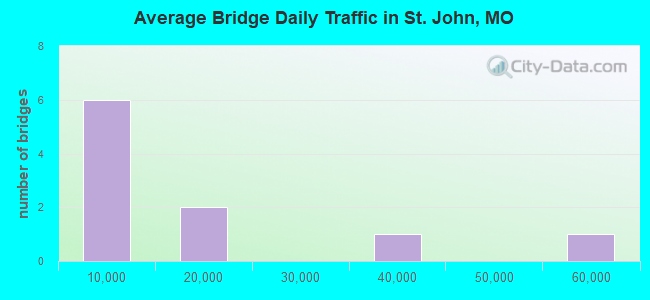
- National Bridge Inventory (NBI) Statistics
- 10Number of bridges
- 85ft / 26.3mTotal length
- 156,800Total average daily traffic
- 9,474Total average daily truck traffic
- National Bridge Inventory (NBI) Registered Bridges for St. John
- No street view available for this location
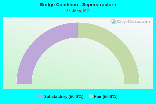
- Bridge Condition - Superstructure
- 50.0%Satisfactory
- 50.0%Fair
Find on map >> Show street view
Structure Number: 2715, Location: S 21 T 46 N R 6 E (Lat: 38.704811, Lng: -90.339386), Route carried "on" structure: Interstate 170, Year Built: 1981, Status: Open, Structure Length: 13.53m (44.39ft), Average Daily Traffic: 36,470 (year 2021), Truck Traffic: 6%, Average Future Daily Traffic: 45,588 (year 2041), Design Load: HS 20+Mod, Features Intersected: RP IS170W TO MO180W, R
Minimum Vertical Clearance: 30+ m (98+ ft), Kilometerpoint: 9.386, Lanes on structure: 3, Lanes under structure: 8, Base Highway Network: Yes, Owner: State Highway Agency, Approaching Roadway Width: 21.0m (68.9ft), Skew: 3 degrees, Material/Design: Steel continuous, Design/Construction: Stringer/Multi-beam, Number Of Spans In Main Unit: 3, Number Of Approach Spans: 4, Length of Maximum Span: 34.7m (113.8ft), Curb-To-Curb Width: 17.1m (56.1ft), Out-to-Out Width: 18.1m (59.4ft)
Condition: Deck: Satisfactory, Superstructure: Satisfactory, Substructure: Satisfactory, Operating Rating: 57.6 metric tons, Method Used To Determine Operating Rating: Load Factor (LF), Inventory Rating: 34.2 metric tons, Method Used To Determine Inventory Rating: Load Factor (LF), Structural Evaluation: Equal to present minimum criteria, Deck Geometry: Equal to present minimum criteria, Underclear: Meets minimum limits, Approach Roadway Alignment: Equal to present desirable criteria, Designated Inspection Frequency: Every 24 months, Inspection Date: September 2020, Deck Structure Type: Concrete Cast-file-Place, Wearing Surface/Protective System: Wearing Surface: Monolithic Concrete, Deck Protection: Epoxy Coated Reinforcing
Find on map >> Show street view
Structure Number: 2716, Location: S 21 T 46 N R 6 E (Lat: 38.705108, Lng: -90.339881), Route carried "on" structure: Interstate 170, Year Built: 1981, Status: Open, Structure Length: 12.80m (41.99ft), Average Daily Traffic: 53,605 (year 2021), Truck Traffic: 4%, Average Future Daily Traffic: 67,006 (year 2041), Design Load: HS 20+Mod, Features Intersected: RP IS170E TO MO180E, RP,
Minimum Vertical Clearance: 30+ m (98+ ft), Kilometerpoint: 8.385, Lanes on structure: 3, Lanes under structure: 8, Base Highway Network: Yes, Owner: State Highway Agency, Approaching Roadway Width: 21.0m (68.9ft), Skew: 3 degrees, Material/Design: Steel continuous, Design/Construction: Stringer/Multi-beam, Number Of Spans In Main Unit: 3, Number Of Approach Spans: 4, Length of Maximum Span: 34.1m (111.9ft), Curb-To-Curb Width: 17.1m (56.1ft), Out-to-Out Width: 18.1m (59.4ft)
Condition: Deck: Satisfactory, Superstructure: Fair, Substructure: Satisfactory, Operating Rating: 58.5 metric tons, Method Used To Determine Operating Rating: Load Factor (LF), Inventory Rating: 32.4 metric tons, Method Used To Determine Inventory Rating: Load Factor (LF), Structural Evaluation: Somewhat better than minimum adequacy, Deck Geometry: Equal to present minimum criteria, Underclear: Meets minimum limits, Approach Roadway Alignment: Equal to present desirable criteria, Designated Inspection Frequency: Every 24 months, Inspection Date: September 2020, Deck Structure Type: Concrete Cast-file-Place, Wearing Surface/Protective System: Wearing Surface: Monolithic Concrete, Deck Protection: Epoxy Coated Reinforcing
Find on map >> Show street view
Structure Number: 2715, Location: S 21 T 46 N R 6 E (Lat: 38.704811, Lng: -90.339386), Route carried "under" structure: Ramp State highway , Year Built: 1981, Structure Length: 0. m, Average Daily Traffic: 4,266 (year 2021), Truck Traffic: 18%, Features Intersected: RP IS170W TO MO180W, Facility Carried by Structure: IS 170 W
Minimum Vertical Clearance: 5.76m (18.90ft), Kilometerpoint: 0.332, Lanes on structure: 3, Lanes under structure: 2, Material/Design: Steel continuous, Design/Construction: Stringer/Multi-beam, Length of Maximum Span: 34.7m (113.8ft)
Find on map >> Show street view
Structure Number: 2715, Location: S 21 T 46 N R 6 E (Lat: 38.704811, Lng: -90.339386), Route carried "under" structure: State highway 180, Year Built: 1981, Structure Length: 0. m, Average Daily Traffic: 11,195 (year 2021), Truck Traffic: 5%, Features Intersected: MO 180, Facility Carried by Structure: IS 170 W
Minimum Vertical Clearance: 5.97m (19.59ft), Kilometerpoint: 5.678, Lanes on structure: 3, Lanes under structure: 2, Material/Design: Steel continuous, Design/Construction: Stringer/Multi-beam, Length of Maximum Span: 34.7m (113.8ft)
Find on map >> Show street view
Structure Number: 2715, Location: S 21 T 46 N R 6 E (Lat: 38.704811, Lng: -90.339386), Route carried "under" structure: State highway 180, Year Built: 1981, Structure Length: 0. m, Average Daily Traffic: 11,000 (year 2021), Truck Traffic: 5%, Features Intersected: MO 180, Facility Carried by Structure: IS 170 W
Minimum Vertical Clearance: 6.00m (19.69ft), Kilometerpoint: 10.355, Lanes on structure: 3, Lanes under structure: 3, Material/Design: Steel continuous, Design/Construction: Stringer/Multi-beam, Length of Maximum Span: 34.7m (113.8ft)
Find on map >> Show street view
Structure Number: 2715, Location: S 21 T 46 N R 6 E (Lat: 38.704811, Lng: -90.339386), Route carried "under" structure: Ramp State highway , Year Built: 1981, Structure Length: 0. m, Average Daily Traffic: 9,802 (year 2021), Truck Traffic: 10%, Features Intersected: RP MO180E TO IS170W, Facility Carried by Structure: IS 170 W
Minimum Vertical Clearance: 6.00m (19.69ft), Kilometerpoint: 0.060, Lanes on structure: 3, Lanes under structure: 1, Material/Design: Steel continuous, Design/Construction: Stringer/Multi-beam, Length of Maximum Span: 34.7m (113.8ft)
Find on map >> Show street view
Structure Number: 2716, Location: S 21 T 46 N R 6 E (Lat: 38.705108, Lng: -90.339881), Route carried "under" structure: Ramp State highway , Year Built: 1981, Structure Length: 0. m, Average Daily Traffic: 2,349 (year 2021), Truck Traffic: 18%, Features Intersected: RP MO180W TO IS170E, Facility Carried by Structure: IS 170 E
Minimum Vertical Clearance: 5.14m (16.86ft), Kilometerpoint: 0.055, Lanes on structure: 3, Lanes under structure: 1, Material/Design: Steel continuous, Design/Construction: Stringer/Multi-beam, Length of Maximum Span: 34.1m (111.9ft)
Find on map >> Show street view
Structure Number: 2716, Location: S 21 T 46 N R 6 E (Lat: 38.705108, Lng: -90.339881), Route carried "under" structure: State highway 180, Year Built: 1981, Structure Length: 0. m, Average Daily Traffic: 9,498 (year 2021), Truck Traffic: 5%, Features Intersected: MO 180, Facility Carried by Structure: IS 170 E
Minimum Vertical Clearance: 5.13m (16.83ft), Kilometerpoint: 10.301, Lanes on structure: 3, Lanes under structure: 2, Material/Design: Steel continuous, Design/Construction: Stringer/Multi-beam, Length of Maximum Span: 34.1m (111.9ft)
Find on map >> Show street view
Structure Number: 2716, Location: S 21 T 46 N R 6 E (Lat: 38.705108, Lng: -90.339881), Route carried "under" structure: State highway 180, Year Built: 1981, Structure Length: 0. m, Average Daily Traffic: 9,409 (year 2021), Truck Traffic: 5%, Features Intersected: MO 180, Facility Carried by Structure: IS 170 E
Minimum Vertical Clearance: 5.23m (17.16ft), Kilometerpoint: 5.731, Lanes on structure: 3, Lanes under structure: 3, Material/Design: Steel continuous, Design/Construction: Stringer/Multi-beam, Length of Maximum Span: 34.1m (111.9ft)
Find on map >> Show street view
Structure Number: 2716, Location: S 21 T 46 N R 6 E (Lat: 38.705108, Lng: -90.339881), Route carried "under" structure: Ramp State highway , Year Built: 1981, Structure Length: 0. m, Average Daily Traffic: 9,206 (year 2021), Truck Traffic: 10%, Features Intersected: RP IS170E TO MO180E, Facility Carried by Structure: IS 170 E
Minimum Vertical Clearance: 5.14m (16.86ft), Kilometerpoint: 0.312, Lanes on structure: 3, Lanes under structure: 2, Material/Design: Steel continuous, Design/Construction: Stringer/Multi-beam, Length of Maximum Span: 34.1m (111.9ft)