Bridge Statistics for Steamboat Rock, Iowa (IA)
Condition, Traffic, Stress, Structural Evaluation, Project Costs
- National Bridge Inventory (NBI) Statistics
- 20Number of bridges
- 367ft / 112mTotal length
- 52,365Total average daily traffic
- 14,091Total average daily truck traffic
- National Bridge Inventory (NBI) Registered Bridges for Steamboat Rock
- No street view available for this location
- New bridges - historical statistics
- 11950-1959
- 11960-1969
- 11970-1979
- 41980-1989
- 21990-1999
- 102000-2009
- 12010-2019
- Bridge Condition - Deck
- 26.7%Very good
- 33.3%Good
- 26.7%Satisfactory
- 6.7%Fair
- 6.7%Failed
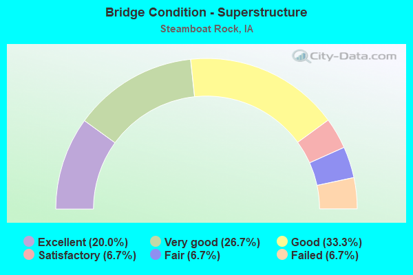
- Bridge Condition - Superstructure
- 20.0%Excellent
- 26.7%Very good
- 33.3%Good
- 6.7%Satisfactory
- 6.7%Fair
- 6.7%Failed
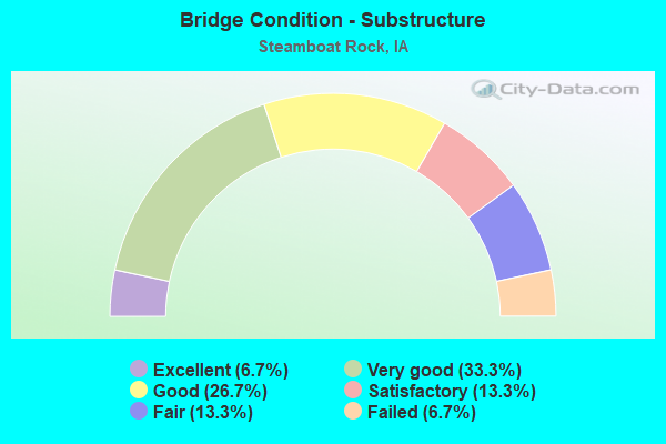
- Bridge Condition - Substructure
- 6.7%Excellent
- 33.3%Very good
- 26.7%Good
- 13.3%Satisfactory
- 13.3%Fair
- 6.7%Failed
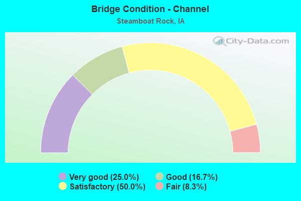
- Bridge Condition - Channel
- 25.0%Very good
- 16.7%Good
- 50.0%Satisfactory
- 8.3%Fair
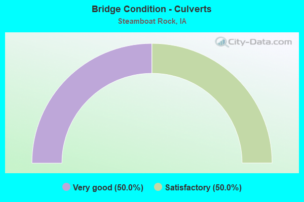
- Bridge Condition - Culverts
- 50.0%Very good
- 50.0%Satisfactory
Find on map >> Show street view
Structure Number: 27161, Location: 088192804 (Lat: 42.404481, Lng: -93.062178), Route carried "on" structure: County highway , Year Built: 2016, Status: Open, Structure Length: 3.38m (11.09ft), Average Daily Traffic: 1,680 (year 2021), Truck Traffic: 5%, Average Future Daily Traffic: 1,680 (year 2039), Design Load: HL 93, Features Intersected: ELK CREEK, Facility Carried by Structure: S 56
Minimum Vertical Clearance: 30+ m (98+ ft), Kilometerpoint: 6.276, Lanes on structure: 2, Owner: County Highway Agency, Approaching Roadway Width: 12.2m (40.0ft), Skew: 1 degrees, Material/Design: Concrete continuous, Design/Construction: Slab, Number Of Spans In Main Unit: 3, Length of Maximum Span: 13.1m (43.0ft), Curb or Sidewalk Widths: Left: 0.4m (1.3ft), Right: 0.4m (1.3ft), Curb-To-Curb Width: 9.3m (30.5ft), Out-to-Out Width: 10.1m (33.1ft)
Condition: Deck: Very good, Superstructure: Very good, Substructure: Very good, Channel: Very good, Operating Rating: 42.1 metric tons, Method Used To Determine Operating Rating: Assigned ratings based on Load and Resistance Factor Design (LRFD) reported by rating factor (RF) using HL93 loadings, Inventory Rating: 32.4 metric tons, Method Used To Determine Inventory Rating: Assigned ratings based on Load and Resistance Factor Design (LRFD) reported by rating factor (RF) using HL93 loadings, Structural Evaluation: Equal to present desirable criteria, Deck Geometry: Somewhat better than minimum adequacy, Waterway Adequacy: Equal to present desirable criteria, Approach Roadway Alignment: Equal to present desirable criteria, Designated Inspection Frequency: Every 48 months, Inspection Date: April 2019, Deck Structure Type: Concrete Cast-file-Place, Wearing Surface/Protective System: Wearing Surface: Monolithic Concrete, Deck Protection: Epoxy Coated Reinforcing
Find on map >> Show street view
Structure Number: 165451, Location: 088183102 (Lat: 42.393081, Lng: -93.002456), Route carried "on" structure: County highway , Year Built: 1987, Status: Open, Structure Length: 0.73m (2.40ft), Average Daily Traffic: 80 (year 2021), Average Future Daily Traffic: 80 (year 2040), Design Load: HS 20, Features Intersected: BRANCH OF IOWA RIVER, Facility Carried by Structure: FM
Minimum Vertical Clearance: 30+ m (98+ ft), Kilometerpoint: 20.410, Lanes on structure: 2, Owner: County Highway Agency, Approaching Roadway Width: 6.7m (22.0ft), Skew: 1 degrees, Material/Design: Concrete continuous, Design/Construction: Culvert, Number Of Spans In Main Unit: 2, Length of Maximum Span: 4.0m (13.1ft)
Condition: Channel: Satisfactory, Culverts: Satisfactory, Operating Rating: 44.1 metric tons, Method Used To Determine Operating Rating: Assigned rating based on Load Factor Design (LFD) reported in metric tons, Inventory Rating: 32.7 metric tons, Method Used To Determine Inventory Rating: Assigned rating based on Load Factor Design (LFD) reported in metric tons, Structural Evaluation: Equal to present minimum criteria, Waterway Adequacy: Better than present minimum criteria, Approach Roadway Alignment: Better than present minimum criteria, Length Of Structure Improvement: 2.40m (7.87ft), Designated Inspection Frequency: Every 48 months, Inspection Date: April 2020, Bridge Improvement Cost: $15,000, Roadway Improvement Cost: $2,000
Find on map >> Show street view
Structure Number: 17521, Location: 087190304 (Lat: 42.381864, Lng: -93.046153), Route carried "on" structure: County highway , Year Built: 1959, Status: Closed, Structure Length: 1.77m (5.81ft), Average Daily Traffic: 50 (year 2013), Average Future Daily Traffic: 50 (year 2039), Features Intersected: PINE CREEK, Facility Carried by Structure: LOCAL
Minimum Vertical Clearance: 30+ m (98+ ft), Kilometerpoint: 13.612, Lanes on structure: 2, Owner: County Highway Agency, Approaching Roadway Width: 9.4m (30.8ft), Material/Design: Prestressed concrete, Design/Construction: Stringer/Multi-beam, Number Of Spans In Main Unit: 1, Length of Maximum Span: 16.8m (55.1ft), Curb-To-Curb Width: 6.2m (20.3ft), Out-to-Out Width: 6.8m (22.3ft)
Condition: Deck: Failed, Superstructure: Failed, Substructure: Failed, Channel: Satisfactory, Deck Geometry: Somewhat better than minimum adequacy, Waterway Adequacy: Better than present minimum criteria, Approach Roadway Alignment: Equal to present minimum criteria, Bridge Posting: Required (Relationship of Operating Rating to Maximum Legal Load: > 39.9% below), Length Of Structure Improvement: 8.80m (28.87ft), Designated Inspection Frequency: Every 24 months, Inspection Date: April 2019, Bridge Improvement Cost: $190,000, Roadway Improvement Cost: $19,000, Deck Structure Type: Concrete Cast-file-Place, Wearing Surface/Protective System: Wearing Surface: Monolithic Concrete
Find on map >> Show street view
Structure Number: 175241, Location: 087191202 (Lat: 42.362708, Lng: -93.021806), Route carried "on" structure: County highway , Year Built: 1999, Status: Open, Structure Length: 1.52m (4.99ft), Average Daily Traffic: 35 (year 2013), Average Future Daily Traffic: 35 (year 2038), Design Load: HS 20, Features Intersected: SMALL STREAM, Facility Carried by Structure: LOCAL
Minimum Vertical Clearance: 30+ m (98+ ft), Kilometerpoint: 17.526, Lanes on structure: 2, Owner: County Highway Agency, Approaching Roadway Width: 9.1m (29.9ft), Material/Design: Prestressed concrete, Design/Construction: Tee Beam, Number Of Spans In Main Unit: 1, Length of Maximum Span: 14.9m (48.9ft), Curb-To-Curb Width: 8.6m (28.2ft), Out-to-Out Width: 8.6m (28.2ft)
Condition: Deck: Very good, Superstructure: Very good, Substructure: Very good, Channel: Very good, Operating Rating: 60.7 metric tons, Method Used To Determine Operating Rating: Load Factor (LF), Inventory Rating: 34.6 metric tons, Method Used To Determine Inventory Rating: Load Factor (LF), Structural Evaluation: Equal to present desirable criteria, Deck Geometry: Better than present minimum criteria, Waterway Adequacy: Better than present minimum criteria, Approach Roadway Alignment: Equal to present desirable criteria, Length Of Structure Improvement: 5.00m (16.40ft), Designated Inspection Frequency: Every 48 months, Inspection Date: Febuary 2018, Bridge Improvement Cost: $15,000, Roadway Improvement Cost: $2,000, Deck Structure Type: Concrete Cast-file-Place, Wearing Surface/Protective System: Wearing Surface: Gravel
Find on map >> Show street view
Structure Number: 176, Location: 088190304 (Lat: 42.470253, Lng: -93.047783), Route carried "on" structure: County highway , Year Built: 1970, Status: Open, Structure Length: 1.68m (5.51ft), Average Daily Traffic: 1,520 (year 2021), Truck Traffic: 11%, Average Future Daily Traffic: 1,520 (year 2040), Features Intersected: CREEK, Facility Carried by Structure: FM
Minimum Vertical Clearance: 30+ m (98+ ft), Kilometerpoint: 13.665, Lanes on structure: 2, Owner: County Highway Agency, Approaching Roadway Width: 11.0m (36.1ft), Skew: 2 degrees, Material/Design: Prestressed concrete, Design/Construction: Stringer/Multi-beam, Number Of Spans In Main Unit: 1, Length of Maximum Span: 16.8m (55.1ft), Curb or Sidewalk Widths: Left: 0.6m (2.0ft), Right: 0.0m, Curb-To-Curb Width: 9.1m (29.9ft), Out-to-Out Width: 9.1m (29.9ft)
Condition: Deck: Fair, Superstructure: Good, Substructure: Satisfactory, Channel: Satisfactory, Operating Rating: 55.1 metric tons, Method Used To Determine Operating Rating: Allowable Stress (AS), Inventory Rating: 25.7 metric tons, Method Used To Determine Inventory Rating: Allowable Stress (AS), Structural Evaluation: Equal to present minimum criteria, Deck Geometry: Somewhat better than minimum adequacy, Waterway Adequacy: Equal to present minimum criteria, Approach Roadway Alignment: Equal to present minimum criteria, Length Of Structure Improvement: 7.80m (25.59ft), Designated Inspection Frequency: Every 24 months, Inspection Date: Febuary 2020, Bridge Improvement Cost: $15,000, Roadway Improvement Cost: $2,000, Deck Structure Type: Concrete Cast-file-Place, Wearing Surface/Protective System: Wearing Surface: Monolithic Concrete
Find on map >> Show street view
Structure Number: 176006, Location: 088192304 (Lat: 42.412894, Lng: -93.026992), Route carried "on" structure: County highway , Year Built: 1992, Status: Open, Structure Length: 1.52m (4.99ft), Average Daily Traffic: 10 (year 2021), Average Future Daily Traffic: 10 (year 2039), Design Load: H 20, Features Intersected: CREEK, Facility Carried by Structure: LOCAL
Minimum Vertical Clearance: 30+ m (98+ ft), Kilometerpoint: 23.099, Lanes on structure: 2, Owner: County Highway Agency, Approaching Roadway Width: 7.3m (24.0ft), Material/Design: Prestressed concrete, Design/Construction: Tee Beam, Number Of Spans In Main Unit: 1, Length of Maximum Span: 15.2m (49.9ft), Curb-To-Curb Width: 8.6m (28.2ft), Out-to-Out Width: 8.8m (28.9ft)
Condition: Deck: Good, Superstructure: Good, Substructure: Good, Channel: Satisfactory, Operating Rating: 61.0 metric tons, Method Used To Determine Operating Rating: Load Factor (LF), Inventory Rating: 34.9 metric tons, Method Used To Determine Inventory Rating: Load Factor (LF), Structural Evaluation: Better than present minimum criteria, Deck Geometry: Better than present minimum criteria, Waterway Adequacy: Better than present minimum criteria, Approach Roadway Alignment: Better than present minimum criteria, Length Of Structure Improvement: 5.00m (16.40ft), Designated Inspection Frequency: Every 48 months, Inspection Date: April 2019, Bridge Improvement Cost: $15,000, Roadway Improvement Cost: $2,000, Deck Structure Type: Concrete Precast Panels, Wearing Surface/Protective System: Wearing Surface: Gravel
Find on map >> Show street view
Structure Number: 176011, Location: 088192601 (Lat: 42.412183, Lng: -93.035839), Route carried "on" structure: County highway , Year Built: 1981, Status: Open, Structure Length: 1.43m (4.69ft), Average Daily Traffic: 30 (year 2013), Average Future Daily Traffic: 30 (year 2040), Features Intersected: ELK CREEK, Facility Carried by Structure: LOCAL
Minimum Vertical Clearance: 30+ m (98+ ft), Kilometerpoint: 6.038, Lanes on structure: 2, Owner: County Highway Agency, Approaching Roadway Width: 8.5m (27.9ft), Material/Design: Prestressed concrete, Design/Construction: Tee Beam, Number Of Spans In Main Unit: 1, Length of Maximum Span: 13.7m (44.9ft), Curb-To-Curb Width: 8.6m (28.2ft), Out-to-Out Width: 8.6m (28.2ft)
Condition: Deck: Satisfactory, Superstructure: Fair, Substructure: Fair, Channel: Good, Operating Rating: 45.8 metric tons, Method Used To Determine Operating Rating: Allowable Stress (AS), Inventory Rating: 32.0 metric tons, Method Used To Determine Inventory Rating: Allowable Stress (AS), Structural Evaluation: Somewhat better than minimum adequacy, Deck Geometry: Better than present minimum criteria, Waterway Adequacy: Equal to present minimum criteria, Approach Roadway Alignment: Better than present minimum criteria, Length Of Structure Improvement: 4.70m (15.42ft), Designated Inspection Frequency: Every 24 months, Inspection Date: Febuary 2020, Bridge Improvement Cost: $15,000, Roadway Improvement Cost: $2,000, Deck Structure Type: Concrete Precast Panels, Wearing Surface/Protective System: Wearing Surface: Gravel
Find on map >> Show street view
Structure Number: 17602, Location: 088192707 (Lat: 42.405517, Lng: -93.050544), Route carried "on" structure: County highway , Year Built: 1964, Status: Open, Structure Length: 1.68m (5.51ft), Average Daily Traffic: 500 (year 2021), Truck Traffic: 16%, Average Future Daily Traffic: 500 (year 2040), Design Load: H 20, Features Intersected: ELK CREEK, Facility Carried by Structure: FM
Minimum Vertical Clearance: 30+ m (98+ ft), Kilometerpoint: 16.660, Lanes on structure: 2, Owner: County Highway Agency, Approaching Roadway Width: 9.8m (32.2ft), Material/Design: Prestressed concrete, Design/Construction: Stringer/Multi-beam, Number Of Spans In Main Unit: 1, Length of Maximum Span: 15.9m (52.2ft), Curb or Sidewalk Widths: Left: 0.6m (2.0ft), Right: 0.0m, Curb-To-Curb Width: 8.5m (27.9ft), Out-to-Out Width: 9.2m (30.2ft)
Condition: Deck: Satisfactory, Superstructure: Satisfactory, Substructure: Fair, Channel: Fair, Operating Rating: 55.1 metric tons, Method Used To Determine Operating Rating: Allowable Stress (AS), Inventory Rating: 25.7 metric tons, Method Used To Determine Inventory Rating: Allowable Stress (AS), Structural Evaluation: Somewhat better than minimum adequacy, Deck Geometry: Somewhat better than minimum adequacy, Waterway Adequacy: Equal to present minimum criteria, Approach Roadway Alignment: Somewhat better than minimum adequacy, Length Of Structure Improvement: 5.50m (18.04ft), Designated Inspection Frequency: Every 24 months, Inspection Date: Febuary 2020, Bridge Improvement Cost: $15,000, Roadway Improvement Cost: $2,000, Deck Structure Type: Concrete Cast-file-Place, Wearing Surface/Protective System: Wearing Surface: Integral Concrete
Find on map >> Show street view
Structure Number: 176051, Location: 088193602 (Lat: 42.383717, Lng: -93.021903), Route carried "on" structure: County highway , Year Built: 1983, Status: Open, Structure Length: 2.44m (8.01ft), Average Daily Traffic: 35 (year 2021), Average Future Daily Traffic: 35 (year 2040), Design Load: H 20, Features Intersected: SMALL, Facility Carried by Structure: FM
Minimum Vertical Clearance: 30+ m (98+ ft), Kilometerpoint: 19.858, Lanes on structure: 2, Owner: County Highway Agency, Approaching Roadway Width: 9.1m (29.9ft), Material/Design: Prestressed concrete, Design/Construction: Stringer/Multi-beam, Number Of Spans In Main Unit: 1, Length of Maximum Span: 24.1m (79.1ft), Curb-To-Curb Width: 8.6m (28.2ft), Out-to-Out Width: 9.1m (29.9ft)
Condition: Deck: Satisfactory, Superstructure: Good, Substructure: Satisfactory, Channel: Good, Operating Rating: 61.9 metric tons, Method Used To Determine Operating Rating: Allowable Stress (AS), Inventory Rating: 23.2 metric tons, Method Used To Determine Inventory Rating: Allowable Stress (AS), Structural Evaluation: Equal to present minimum criteria, Deck Geometry: Better than present minimum criteria, Waterway Adequacy: Better than present minimum criteria, Approach Roadway Alignment: Equal to present minimum criteria, Length Of Structure Improvement: 8.00m (26.25ft), Designated Inspection Frequency: Every 24 months, Inspection Date: Febuary 2020, Bridge Improvement Cost: $15,000, Roadway Improvement Cost: $2,000, Deck Structure Type: Concrete Precast Panels, Wearing Surface/Protective System: Wearing Surface: Gravel
Find on map >> Show street view
Structure Number: 176101, Location: 088201205 (Lat: 42.444433, Lng: -93.126281), Route carried "on" structure: County highway , Year Built: 1982, Status: Open, Structure Length: 6.52m (21.39ft), Average Daily Traffic: 45 (year 2013), Average Future Daily Traffic: 45 (year 2040), Design Load: H 20, Features Intersected: IOWA RIVER, Facility Carried by Structure: FM
Minimum Vertical Clearance: 30+ m (98+ ft), Kilometerpoint: 3.394, Lanes on structure: 2, Owner: County Highway Agency, Approaching Roadway Width: 9.1m (29.9ft), Skew: 3 degrees, Material/Design: Prestressed concrete, Design/Construction: Stringer/Multi-beam, Number Of Spans In Main Unit: 3, Length of Maximum Span: 23.5m (77.1ft), Curb-To-Curb Width: 9.1m (29.9ft), Out-to-Out Width: 9.1m (29.9ft)
Condition: Deck: Satisfactory, Superstructure: Good, Substructure: Good, Channel: Satisfactory, Operating Rating: 72.0 metric tons, Method Used To Determine Operating Rating: Allowable Stress (AS), Inventory Rating: 30.7 metric tons, Method Used To Determine Inventory Rating: Allowable Stress (AS), Structural Evaluation: Better than present minimum criteria, Deck Geometry: Better than present minimum criteria, Waterway Adequacy: Equal to present desirable criteria, Approach Roadway Alignment: Equal to present desirable criteria, Length Of Structure Improvement: 21.40m (70.21ft), Designated Inspection Frequency: Every 24 months, Inspection Date: Febuary 2020, Bridge Improvement Cost: $15,000, Roadway Improvement Cost: $2,000, Deck Structure Type: Concrete Precast Panels, Wearing Surface/Protective System: Wearing Surface: Monolithic Concrete
Find on map >> Show street view
Structure Number: 607875, Location: 2.4 MILES W OF JCT SR S56 (Lat: 42.429511, Lng: -93.080836), Route carried "on" structure: County highway , Year Built: 2003, Status: Open, Structure Length: 8.53m (27.99ft), Average Daily Traffic: 90 (year 2021), Average Future Daily Traffic: 90 (year 2040), Design Load: HS 20, Features Intersected: US 20, Facility Carried by Structure: V AVENUE
Minimum Vertical Clearance: 30+ m (98+ ft), Kilometerpoint: 10.668, Lanes on structure: 2, Lanes under structure: 4, Owner: State Highway Agency, Approaching Roadway Width: 9.1m (29.9ft), Skew: 3 degrees, Material/Design: Steel, Design/Construction: Stringer/Multi-beam, Number Of Spans In Main Unit: 2, Length of Maximum Span: 42.1m (138.1ft), Curb-To-Curb Width: 9.0m (29.5ft), Out-to-Out Width: 10.0m (32.8ft)
Condition: Deck: Good, Superstructure: Excellent, Substructure: Good, Operating Rating: 60.9 metric tons, Method Used To Determine Operating Rating: Load Factor (LF), Inventory Rating: 36.6 metric tons, Method Used To Determine Inventory Rating: Load Factor (LF), Structural Evaluation: Better than present minimum criteria, Deck Geometry: Better than present minimum criteria, Underclear: Equal to present minimum criteria, Approach Roadway Alignment: Equal to present desirable criteria, Designated Inspection Frequency: Every 24 months, Inspection Date: September 2020, Deck Structure Type: Concrete Cast-file-Place, Wearing Surface/Protective System: Wearing Surface: Monolithic Concrete, Deck Protection: Epoxy Coated Reinforcing
Find on map >> Show street view
Structure Number: 60788, Location: 1.2 MILES E OF JCT SR D35 (Lat: 42.426006, Lng: -93.119061), Route carried "on" structure: County highway , Year Built: 2003, Status: Open, Structure Length: 6.83m (22.41ft), Average Daily Traffic: 110 (year 2021), Average Future Daily Traffic: 110 (year 2040), Design Load: HS 20, Features Intersected: US 20, Facility Carried by Structure: T AVENUE
Minimum Vertical Clearance: 30+ m (98+ ft), Kilometerpoint: 21.226, Lanes on structure: 2, Lanes under structure: 4, Owner: State Highway Agency, Approaching Roadway Width: 9.1m (29.9ft), Skew: 2 degrees, Material/Design: Prestressed concrete, Design/Construction: Stringer/Multi-beam, Number Of Spans In Main Unit: 2, Length of Maximum Span: 33.8m (110.9ft), Curb-To-Curb Width: 9.0m (29.5ft), Out-to-Out Width: 10.0m (32.8ft)
Condition: Deck: Very good, Superstructure: Excellent, Substructure: Excellent, Operating Rating: 90.5 metric tons, Method Used To Determine Operating Rating: Load Factor (LF), Inventory Rating: 43.6 metric tons, Method Used To Determine Inventory Rating: Load Factor (LF), Structural Evaluation: Superior to present desirable criteria, Deck Geometry: Equal to present minimum criteria, Underclear: Somewhat better than minimum adequacy, Approach Roadway Alignment: Equal to present desirable criteria, Designated Inspection Frequency: Every 24 months, Inspection Date: August 2020, Deck Structure Type: Concrete Cast-file-Place, Wearing Surface/Protective System: Wearing Surface: Monolithic Concrete, Deck Protection: Epoxy Coated Reinforcing
Find on map >> Show street view
Structure Number: 60789, Location: AT JUNCTION WITH SR S56 (Lat: 42.456128, Lng: -93.051647), Route carried "on" structure: County highway , Year Built: 2003, Status: Open, Structure Length: 9.27m (30.41ft), Average Daily Traffic: 1,480 (year 2021), Truck Traffic: 15%, Average Future Daily Traffic: 1,480 (year 2038), Design Load: HS 20, Features Intersected: US 20, Facility Carried by Structure: S 56
Minimum Vertical Clearance: 30+ m (98+ ft), Kilometerpoint: 11.930, Lanes on structure: 2, Lanes under structure: 6, Owner: State Highway Agency, Approaching Roadway Width: 13.4m (44.0ft), Skew: 3 degrees, Material/Design: Steel, Design/Construction: Stringer/Multi-beam, Number Of Spans In Main Unit: 2, Length of Maximum Span: 46.6m (152.9ft), Curb-To-Curb Width: 10.8m (35.4ft), Out-to-Out Width: 11.8m (38.7ft)
Condition: Deck: Very good, Superstructure: Very good, Substructure: Very good, Operating Rating: 67.6 metric tons, Method Used To Determine Operating Rating: Load Factor (LF), Inventory Rating: 40.5 metric tons, Method Used To Determine Inventory Rating: Load Factor (LF), Structural Evaluation: Equal to present desirable criteria, Deck Geometry: Equal to present minimum criteria, Underclear: Meets minimum limits, Approach Roadway Alignment: Equal to present desirable criteria, Designated Inspection Frequency: Every 24 months, Inspection Date: September 2018, Deck Structure Type: Concrete Cast-file-Place, Wearing Surface/Protective System: Wearing Surface: Monolithic Concrete, Deck Protection: Epoxy Coated Reinforcing
Find on map >> Show street view
Structure Number: 60791, Location: 0.4 MI WEST OF JCT SR S56 (Lat: 42.453033, Lng: -93.058008), Route carried "on" structure: US 20, Year Built: 2003, Status: Open, Structure Length: 6.64m (21.78ft), Average Daily Traffic: 3,800 (year 2020), Truck Traffic: 30%, Average Future Daily Traffic: 3,800 (year 2040), Design Load: HS 20, Features Intersected: IOWA RIVER RR
Minimum Vertical Clearance: 30+ m (98+ ft), Kilometerpoint: 279.860, Lanes on structure: 2, Base Highway Network: Yes, Owner: State Highway Agency, Approaching Roadway Width: 13.4m (44.0ft), Skew: 2 degrees, Material/Design: Prestressed concrete, Design/Construction: Stringer/Multi-beam, Number Of Spans In Main Unit: 3, Length of Maximum Span: 25.0m (82.0ft), Curb-To-Curb Width: 19.7m (64.6ft), Out-to-Out Width: 20.6m (67.6ft)
Condition: Deck: Good, Superstructure: Excellent, Substructure: Good, Operating Rating: 76.4 metric tons, Method Used To Determine Operating Rating: Load Factor (LF), Inventory Rating: 37.7 metric tons, Method Used To Determine Inventory Rating: Load Factor (LF), Structural Evaluation: Better than present minimum criteria, Deck Geometry: Superior to present desirable criteria, Underclear: Equal to present minimum criteria, Approach Roadway Alignment: Equal to present desirable criteria, Designated Inspection Frequency: Every 24 months, Inspection Date: September 2020, Deck Structure Type: Concrete Cast-file-Place, Wearing Surface/Protective System: Wearing Surface: Monolithic Concrete, Deck Protection: Epoxy Coated Reinforcing
Find on map >> Show street view
Structure Number: 607915, Location: 0.4 MILES W OF JCT SR S56 (Lat: 42.453694, Lng: -93.057411), Route carried "on" structure: US 20, Year Built: 2003, Status: Open, Structure Length: 6.64m (21.78ft), Average Daily Traffic: 3,800 (year 2020), Truck Traffic: 30%, Average Future Daily Traffic: 3,800 (year 2040), Design Load: HS 20, Features Intersected: IOWA RIVER RR
Minimum Vertical Clearance: 30+ m (98+ ft), Kilometerpoint: 203.262, Lanes on structure: 2, Owner: State Highway Agency, Approaching Roadway Width: 13.4m (44.0ft), Skew: 2 degrees, Material/Design: Prestressed concrete, Design/Construction: Stringer/Multi-beam, Number Of Spans In Main Unit: 3, Length of Maximum Span: 25.0m (82.0ft), Curb-To-Curb Width: 12.0m (39.4ft), Out-to-Out Width: 13.0m (42.7ft)
Condition: Deck: Good, Superstructure: Very good, Substructure: Very good, Operating Rating: 76.4 metric tons, Method Used To Determine Operating Rating: Load Factor (LF), Inventory Rating: 37.7 metric tons, Method Used To Determine Inventory Rating: Load Factor (LF), Structural Evaluation: Equal to present desirable criteria, Deck Geometry: Better than present minimum criteria, Underclear: Somewhat better than minimum adequacy, Approach Roadway Alignment: Equal to present desirable criteria, Designated Inspection Frequency: Every 24 months, Inspection Date: September 2020, Deck Structure Type: Concrete Cast-file-Place, Wearing Surface/Protective System: Wearing Surface: Monolithic Concrete, Deck Protection: Epoxy Coated Reinforcing
Find on map >> Show street view
Structure Number: 608325, Location: 0.3 MILE E OF JCT SR S56 (Lat: 42.458792, Lng: -93.047225), Route carried "on" structure: US 20, Year Built: 2003, Status: Open, Structure Length: 1.28m (4.20ft), Average Daily Traffic: 7,900 (year 2020), Truck Traffic: 29%, Average Future Daily Traffic: 7,900 (year 2040), Design Load: HS 20, Features Intersected: DRAINAGE
Minimum Vertical Clearance: 30+ m (98+ ft), Kilometerpoint: 280.953, Lanes on structure: 5, Base Highway Network: Yes, Owner: State Highway Agency, Approaching Roadway Width: 26.8m (87.9ft), Skew: 24 degrees, Material/Design: Concrete continuous, Design/Construction: Culvert, Number Of Spans In Main Unit: 3, Length of Maximum Span: 4.3m (14.1ft)
Condition: Channel: Satisfactory, Culverts: Very good, Operating Rating: 52.5 metric tons, Method Used To Determine Operating Rating: Load and Resistance Factor Rating (LRFR) rating reported by rating factor(RF) method using HL-93 loadings, Inventory Rating: 40.5 metric tons, Method Used To Determine Inventory Rating: Load and Resistance Factor Rating (LRFR) rating reported by rating factor(RF) method using HL-93 loadings, Structural Evaluation: Equal to present desirable criteria, Waterway Adequacy: Equal to present desirable criteria, Approach Roadway Alignment: Equal to present desirable criteria, Designated Inspection Frequency: Every 24 months, Inspection Date: August 2020
Find on map >> Show street view
Structure Number: 60835, Location: 1.5 mi. W of Jct. SR S56 (Lat: 42.436978, Lng: -93.073183), Route carried "on" structure: US 20, Year Built: 2003, Status: Open, Structure Length: 49.96m (163.91ft), Average Daily Traffic: 7,700 (year 2020), Truck Traffic: 29%, Average Future Daily Traffic: 7,700 (year 2040), Design Load: HS 20, Features Intersected: IOWA RIVER
Minimum Vertical Clearance: 30+ m (98+ ft), Kilometerpoint: 277.665, Lanes on structure: 4, Base Highway Network: Yes, Owner: State Highway Agency, Approaching Roadway Width: 25.9m (85.0ft), Skew: 30 degrees, Material/Design: Steel continuous, Design/Construction: Stringer/Multi-beam, Number Of Spans In Main Unit: 5, Number Of Approach Spans: 2, Length of Maximum Span: 92.1m (302.2ft), Curb-To-Curb Width: 24.0m (78.7ft), Out-to-Out Width: 25.7m (84.3ft)
Condition: Deck: Good, Superstructure: Good, Substructure: Very good, Channel: Very good, Operating Rating: 57.7 metric tons, Method Used To Determine Operating Rating: Load Factor (LF), Inventory Rating: 34.6 metric tons, Method Used To Determine Inventory Rating: Load Factor (LF), Structural Evaluation: Better than present minimum criteria, Deck Geometry: Superior to present desirable criteria, Waterway Adequacy: Equal to present desirable criteria, Approach Roadway Alignment: Equal to present desirable criteria, Designated Inspection Frequency: Every 24 months, Inspection Date: August 2020, Deck Structure Type: Concrete Cast-file-Place, Wearing Surface/Protective System: Wearing Surface: Monolithic Concrete, Deck Protection: Epoxy Coated Reinforcing
Find on map >> Show street view
Structure Number: 607875, Location: 2.4 MILES W OF JCT SR S56 (Lat: 42.429511, Lng: -93.080836), Route carried "under" structure: US 20, Year Built: 2003, Structure Length: 0. m, Average Daily Traffic: 7,700 (year 2020), Truck Traffic: 29%, Features Intersected: US 20, Facility Carried by Structure: V AVENUE
Minimum Vertical Clearance: 30+ m (98+ ft), Kilometerpoint: 276.629, Lanes on structure: 2, Lanes under structure: 4, Material/Design: Steel, Design/Construction: Stringer/Multi-beam, Length of Maximum Span: 42.1m (138.1ft)
Find on map >> Show street view
Structure Number: 60788, Location: 1.2 MILES E OF JCT SR D35 (Lat: 42.426006, Lng: -93.119061), Route carried "under" structure: US 20, Year Built: 2003, Structure Length: 0. m, Average Daily Traffic: 7,700 (year 2020), Truck Traffic: 29%, Features Intersected: US 20, Facility Carried by Structure: T AVENUE
Minimum Vertical Clearance: 30+ m (98+ ft), Kilometerpoint: 273.400, Lanes on structure: 2, Lanes under structure: 4, Material/Design: Prestressed concrete, Design/Construction: Stringer/Multi-beam, Length of Maximum Span: 33.8m (110.9ft)
Find on map >> Show street view
Structure Number: 60789, Location: AT JUNCTION WITH SR S56 (Lat: 42.456128, Lng: -93.051647), Route carried "under" structure: US 20, Year Built: 2003, Structure Length: 0. m, Average Daily Traffic: 8,100 (year 2020), Truck Traffic: 28%, Features Intersected: US 20, Facility Carried by Structure: S 56
Minimum Vertical Clearance: 30+ m (98+ ft), Kilometerpoint: 280.501, Lanes on structure: 2, Lanes under structure: 6, Material/Design: Steel, Design/Construction: Stringer/Multi-beam, Length of Maximum Span: 46.6m (152.9ft)