Bridge Statistics for Sterling, Colorado (CO)
Condition, Traffic, Stress, Structural Evaluation, Project Costs
- National Bridge Inventory (NBI) Statistics
- 40Number of bridges
- 420ft / 128mTotal length
- $640,000Total costs
- 136,136Total average daily traffic
- 24,572Total average daily truck traffic
- National Bridge Inventory (NBI) Registered Bridges for Sterling
- No street view available for this location
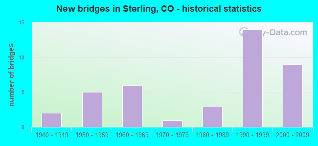
- New bridges - historical statistics
- 21940-1949
- 51950-1959
- 61960-1969
- 11970-1979
- 31980-1989
- 141990-1999
- 92000-2009
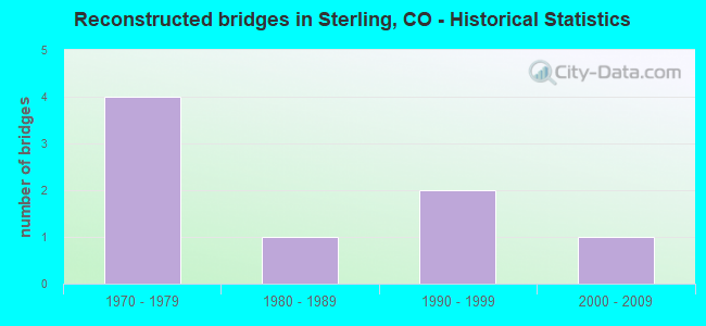
- Reconstructed bridges - Historical Statistics
- 41970-1979
- 11980-1989
- 21990-1999
- 12000-2009
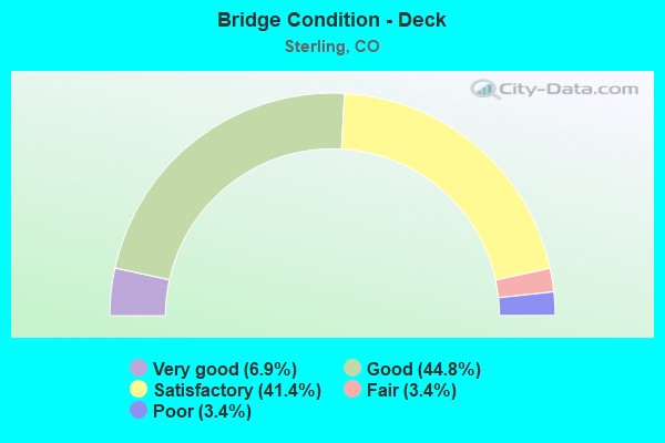
- Bridge Condition - Deck
- 6.9%Very good
- 44.8%Good
- 41.4%Satisfactory
- 3.4%Fair
- 3.4%Poor
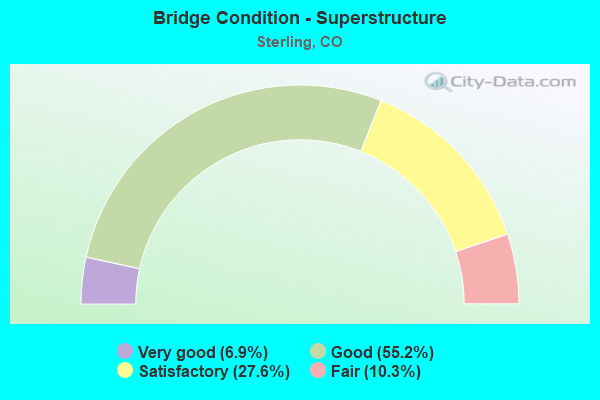
- Bridge Condition - Superstructure
- 6.9%Very good
- 55.2%Good
- 27.6%Satisfactory
- 10.3%Fair
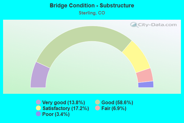
- Bridge Condition - Substructure
- 13.8%Very good
- 58.6%Good
- 17.2%Satisfactory
- 6.9%Fair
- 3.4%Poor

- Bridge Condition - Channel
- 40.0%Very good
- 44.0%Good
- 12.0%Satisfactory
- 4.0%Fair
Find on map >> Show street view
Structure Number: B-23-I, Location: 2 MI W OF STERLING (Lat: 40.623678, Lng: -103.257275), Route carried "on" structure: State highway 14C, Year Built: 1965, Status: Open, Structure Length: 0.86m (2.82ft), Average Daily Traffic: 3,500 (year 2020), Truck Traffic: 11%, Average Future Daily Traffic: 3,990 (year 2040), Design Load: HS 20, Features Intersected: PAWNEE DITCH, Facility Carried by Structure: SH 14 ML
Minimum Vertical Clearance: 30+ m (98+ ft), Kilometerpoint: 159.737, Lanes on structure: 5, Base Highway Network: Yes, Owner: State Highway Agency, Approaching Roadway Width: 20.7m (67.9ft), Skew: 4 degrees, Material/Design: Concrete, Design/Construction: Culvert, Number Of Spans In Main Unit: 1, Length of Maximum Span: 8.6m (28.2ft), Curb-To-Curb Width: 16.5m (54.1ft), Out-to-Out Width: 23.9m (78.4ft)
Condition: Channel: Very good, Culverts: Satisfactory, Operating Rating: 36.3 metric tons, Method Used To Determine Operating Rating: Field evaluation and documented engineering judgment, Inventory Rating: 32.7 metric tons, Method Used To Determine Inventory Rating: Field evaluation and documented engineering judgment, Structural Evaluation: Equal to present minimum criteria, Deck Geometry: High priority of replacement, Waterway Adequacy: Equal to present desirable criteria, Approach Roadway Alignment: Equal to present desirable criteria, Designated Inspection Frequency: Every 24 months, Inspection Date: November 2021
Find on map >> Show street view
Structure Number: B-24-A, Location: 4.7 MI NE OF JCT SH 63 (Lat: 40.600572, Lng: -103.222186), Route carried "on" structure: US 6J, Year Built: 1941, Status: Open, Structure Length: 0.97m (3.18ft), Average Daily Traffic: 2,150 (year 2020), Truck Traffic: 6%, Average Future Daily Traffic: 2,580 (year 2040), Design Load: H 15, Features Intersected: STERLING CANAL NO 1, Facility Carried by Structure: US 6 ML EBND
Minimum Vertical Clearance: 30+ m (98+ ft), Kilometerpoint: 49.857, Lanes on structure: 2, Base Highway Network: Yes, Owner: State Highway Agency, Approaching Roadway Width: 10.7m (35.1ft), Skew: 4 degrees, Material/Design: Steel, Design/Construction: Stringer/Multi-beam, Number Of Spans In Main Unit: 1, Length of Maximum Span: 8.2m (26.9ft), Curb or Sidewalk Widths: Left: 0.9m (3.0ft), Right: 0.0m, Curb-To-Curb Width: 9.1m (29.9ft), Out-to-Out Width: 11.0m (36.1ft)
Condition: Deck: Poor, Superstructure: Fair, Substructure: Satisfactory, Channel: Very good, Operating Rating: 41.7 metric tons, Method Used To Determine Operating Rating: Load Factor (LF), Inventory Rating: 24.5 metric tons, Method Used To Determine Inventory Rating: Load Factor (LF), Structural Evaluation: Somewhat better than minimum adequacy, Deck Geometry: Meets minimum limits, Waterway Adequacy: Equal to present desirable criteria, Approach Roadway Alignment: Equal to present desirable criteria, Designated Inspection Frequency: Every 24 months, Inspection Date: November 2021, Deck Structure Type: Concrete Cast-file-Place, Wearing Surface/Protective System: Wearing Surface: Bituminous
Find on map >> Show street view
Structure Number: B-24-AN, Location: 35 MI NE OF JCT US 34 (Lat: 40.642767, Lng: -103.151122), Route carried "on" structure: Interstate 76A, Year Built: 1966, Year Reconstructed: 1985, Status: Open, Structure Length: 4.95m (16.24ft), Average Daily Traffic: 4,150 (year 2020), Truck Traffic: 36%, Average Future Daily Traffic: 5,437 (year 2040), Design Load: HS 20+Mod, Features Intersected: BNSF RR, Facility Carried by Structure: I 76 ML EBND
Minimum Vertical Clearance: 30+ m (98+ ft), Kilometerpoint: 203.685, Lanes on structure: 2, Base Highway Network: Yes, Owner: State Highway Agency, Approaching Roadway Width: 11.6m (38.1ft), Skew: 14 degrees, Material/Design: Steel continuous, Design/Construction: Stringer/Multi-beam, Number Of Spans In Main Unit: 3, Length of Maximum Span: 16.2m (53.1ft), Curb-To-Curb Width: 11.6m (38.1ft), Out-to-Out Width: 12.3m (40.4ft)
Condition: Deck: Satisfactory, Superstructure: Good, Substructure: Good, Operating Rating: 59.8 metric tons, Method Used To Determine Operating Rating: Load Factor (LF), Inventory Rating: 35.8 metric tons, Method Used To Determine Inventory Rating: Load Factor (LF), Structural Evaluation: Better than present minimum criteria, Deck Geometry: Equal to present minimum criteria, Underclear: Equal to present minimum criteria, Approach Roadway Alignment: Equal to present desirable criteria, Designated Inspection Frequency: Every 24 months, Inspection Date: May 2021, Deck Structure Type: Concrete Cast-file-Place, Wearing Surface/Protective System: Wearing Surface: Bituminous, Membrane: Built-up, Deck Protection: Epoxy Coated Reinforcing
Find on map >> Show street view
Structure Number: B-24-AO, Location: 38.3 MI SE OF JCT SH 59 (Lat: 40.642614, Lng: -103.151692), Route carried "on" structure: Interstate 76A, Year Built: 1966, Year Reconstructed: 1999, Status: Open, Structure Length: 4.95m (16.24ft), Average Daily Traffic: 4,150 (year 2020), Truck Traffic: 36%, Average Future Daily Traffic: 5,437 (year 2040), Design Load: HS 20+Mod, Features Intersected: BNSF RR, Facility Carried by Structure: I 76 ML WBND
Minimum Vertical Clearance: 30+ m (98+ ft), Kilometerpoint: 203.651, Lanes on structure: 2, Base Highway Network: Yes, Owner: State Highway Agency, Approaching Roadway Width: 11.6m (38.1ft), Skew: 14 degrees, Material/Design: Steel continuous, Design/Construction: Stringer/Multi-beam, Number Of Spans In Main Unit: 3, Length of Maximum Span: 15.7m (51.5ft), Curb-To-Curb Width: 11.6m (38.1ft), Out-to-Out Width: 12.3m (40.4ft)
Condition: Deck: Good, Superstructure: Good, Substructure: Good, Operating Rating: 61.5 metric tons, Method Used To Determine Operating Rating: Load Factor (LF), Inventory Rating: 36.8 metric tons, Method Used To Determine Inventory Rating: Load Factor (LF), Structural Evaluation: Better than present minimum criteria, Deck Geometry: Equal to present minimum criteria, Underclear: Equal to present minimum criteria, Approach Roadway Alignment: Equal to present desirable criteria, Designated Inspection Frequency: Every 24 months, Inspection Date: May 2021, Deck Structure Type: Concrete Cast-file-Place, Wearing Surface/Protective System: Wearing Surface: Bituminous, Membrane: Preformed Fabric, Deck Protection: Epoxy Coated Reinforcing
Find on map >> Show street view
Structure Number: B-24-AQ, Location: IN STERLING (Lat: 40.625689, Lng: -103.205692), Route carried "on" structure: US 6J, Year Built: 1972, Status: Open, Structure Length: 45.99m (150.89ft), Average Daily Traffic: 9,900 (year 2020), Truck Traffic: 16%, Average Future Daily Traffic: 13,761 (year 2040), Design Load: HS 20, Features Intersected: CITY STREETS, UP RR, Facility Carried by Structure: US 6 ML
Minimum Vertical Clearance: 30+ m (98+ ft), Kilometerpoint: 53.147, Lanes on structure: 4, Lanes under structure: 6, Base Highway Network: Yes, Owner: State Highway Agency, Approaching Roadway Width: 17.7m (58.1ft), Material/Design: Prestressed concrete continuous, Design/Construction: Stringer/Multi-beam, Number Of Spans In Main Unit: 12, Length of Maximum Span: 37.2m (122.0ft), Curb or Sidewalk Widths: Left: 0.0m, Right: 1.8m (5.9ft), Curb-To-Curb Width: 17.7m (58.1ft), Out-to-Out Width: 19.9m (65.3ft)
Condition: Deck: Satisfactory, Superstructure: Good, Substructure: Satisfactory, Operating Rating: 55.1 metric tons, Method Used To Determine Operating Rating: Load Factor (LF), Inventory Rating: 27.6 metric tons, Method Used To Determine Inventory Rating: Load Factor (LF), Structural Evaluation: Equal to present minimum criteria, Deck Geometry: Somewhat better than minimum adequacy, Underclear: Equal to present minimum criteria, Approach Roadway Alignment: Equal to present desirable criteria, Designated Inspection Frequency: Every 24 months, Inspection Date: August 2021, Deck Structure Type: Concrete Cast-file-Place, Wearing Surface/Protective System: Wearing Surface: Bituminous, Membrane: Built-up
Find on map >> Show street view
Structure Number: B-24-AS, Location: STERLING EXIT (Lat: 40.620697, Lng: -103.173658), Route carried "on" structure: Interstate 76A, Year Built: 1994, Status: Open, Structure Length: 6.50m (21.33ft), Average Daily Traffic: 4,250 (year 2020), Truck Traffic: 22%, Average Future Daily Traffic: 5,398 (year 2040), Design Load: HS 20, Features Intersected: US 6 ML, Facility Carried by Structure: I 76 ML WBND
Minimum Vertical Clearance: 30+ m (98+ ft), Kilometerpoint: 200.569, Lanes on structure: 2, Lanes under structure: 4, Base Highway Network: Yes, Owner: State Highway Agency, Approaching Roadway Width: 11.6m (38.1ft), Skew: 3 degrees, Material/Design: Prestressed concrete continuous, Design/Construction: Stringer/Multi-beam, Number Of Spans In Main Unit: 2, Length of Maximum Span: 32.0m (105.0ft), Curb-To-Curb Width: 11.6m (38.1ft), Out-to-Out Width: 12.3m (40.4ft)
Condition: Deck: Good, Superstructure: Good, Substructure: Good, Operating Rating: 96.4 metric tons, Method Used To Determine Operating Rating: Load Factor (LF), Inventory Rating: 46.7 metric tons, Method Used To Determine Inventory Rating: Load Factor (LF), Structural Evaluation: Better than present minimum criteria, Deck Geometry: Equal to present minimum criteria, Underclear: Somewhat better than minimum adequacy, Approach Roadway Alignment: Equal to present desirable criteria, Designated Inspection Frequency: Every 24 months, Inspection Date: June 2021, Deck Structure Type: Concrete Cast-file-Place, Wearing Surface/Protective System: Wearing Surface: Bituminous, Membrane: Built-up, Deck Protection: Epoxy Coated Reinforcing
Find on map >> Show street view
Structure Number: B-24-AT, Location: STERLING EXIT (Lat: 40.620789, Lng: -103.172558), Route carried "on" structure: Interstate 76A, Year Built: 1994, Status: Open, Structure Length: 6.37m (20.90ft), Average Daily Traffic: 4,250 (year 2020), Truck Traffic: 22%, Average Future Daily Traffic: 5,398 (year 2040), Design Load: HS 20, Features Intersected: US 6 ML, Facility Carried by Structure: I 76 ML EBND
Minimum Vertical Clearance: 30+ m (98+ ft), Kilometerpoint: 200.611, Lanes on structure: 2, Lanes under structure: 4, Base Highway Network: Yes, Owner: State Highway Agency, Approaching Roadway Width: 11.6m (38.1ft), Skew: 14 degrees, Material/Design: Prestressed concrete continuous, Design/Construction: Stringer/Multi-beam, Number Of Spans In Main Unit: 2, Length of Maximum Span: 34.0m (111.5ft), Curb-To-Curb Width: 11.6m (38.1ft), Out-to-Out Width: 12.3m (40.4ft)
Condition: Deck: Good, Superstructure: Good, Substructure: Good, Operating Rating: 94.8 metric tons, Method Used To Determine Operating Rating: Load Factor (LF), Inventory Rating: 33.2 metric tons, Method Used To Determine Inventory Rating: Load Factor (LF), Structural Evaluation: Better than present minimum criteria, Deck Geometry: Equal to present minimum criteria, Underclear: High priority of corrective action, Approach Roadway Alignment: Equal to present desirable criteria, Designated Inspection Frequency: Every 24 months, Inspection Date: June 2021, Deck Structure Type: Concrete Cast-file-Place, Wearing Surface/Protective System: Wearing Surface: Bituminous, Membrane: Built-up, Deck Protection: Epoxy Coated Reinforcing
Find on map >> Show street view
Structure Number: B-24-AW, Location: 4.5 MI SW OF STERLING EXT (Lat: 40.562283, Lng: -103.209769), Route carried "on" structure: Interstate 76A, Year Built: 2003, Status: Open, Structure Length: 2.68m (8.79ft), Average Daily Traffic: 4,250 (year 2020), Truck Traffic: 22%, Average Future Daily Traffic: 5,398 (year 2040), Design Load: HL 93, Features Intersected: FARM ROAD, Facility Carried by Structure: I76 ML EBND
Minimum Vertical Clearance: 30+ m (98+ ft), Kilometerpoint: 193.395, Lanes on structure: 2, Lanes under structure: 2, Base Highway Network: Yes, Owner: State Highway Agency, Approaching Roadway Width: 11.6m (38.1ft), Material/Design: Prestressed concrete, Design/Construction: Stringer/Multi-beam, Number Of Spans In Main Unit: 1, Length of Maximum Span: 26.2m (86.0ft), Curb-To-Curb Width: 11.6m (38.1ft), Out-to-Out Width: 12.5m (41.0ft)
Condition: Deck: Good, Superstructure: Very good, Substructure: Good, Operating Rating: 60.3 metric tons, Method Used To Determine Operating Rating: Load and Resistance Factor Rating (LRFR) rating reported by rating factor(RF) method using HL-93 loadings, Inventory Rating: 45.4 metric tons, Method Used To Determine Inventory Rating: Load and Resistance Factor Rating (LRFR) rating reported by rating factor(RF) method using HL-93 loadings, Structural Evaluation: Better than present minimum criteria, Deck Geometry: Equal to present minimum criteria, Underclear: Meets minimum limits, Approach Roadway Alignment: Equal to present desirable criteria, Designated Inspection Frequency: Every 24 months, Inspection Date: June 2021, Deck Structure Type: Concrete Precast Panels, Wearing Surface/Protective System: Wearing Surface: Bituminous, Membrane: Preformed Fabric, Deck Protection: Epoxy Coated Reinforcing
Find on map >> Show street view
Structure Number: B-24-AX, Location: 4.5 MI SW OF STERLING EXT (Lat: 40.562444, Lng: -103.210181), Route carried "on" structure: Interstate 76A, Year Built: 2003, Status: Open, Structure Length: 2.70m (8.86ft), Average Daily Traffic: 4,250 (year 2020), Truck Traffic: 22%, Average Future Daily Traffic: 5,398 (year 2040), Design Load: HL 93, Features Intersected: FARM ROAD, Facility Carried by Structure: I 76 ML WBND
Minimum Vertical Clearance: 30+ m (98+ ft), Kilometerpoint: 193.395, Lanes on structure: 2, Lanes under structure: 2, Base Highway Network: Yes, Owner: State Highway Agency, Approaching Roadway Width: 11.6m (38.1ft), Material/Design: Prestressed concrete, Design/Construction: Stringer/Multi-beam, Number Of Spans In Main Unit: 1, Length of Maximum Span: 26.2m (86.0ft), Curb-To-Curb Width: 11.6m (38.1ft), Out-to-Out Width: 12.5m (41.0ft)
Condition: Deck: Good, Superstructure: Good, Substructure: Good, Operating Rating: 58.3 metric tons, Method Used To Determine Operating Rating: Load and Resistance Factor Rating (LRFR) rating reported by rating factor(RF) method using HL-93 loadings, Inventory Rating: 44.1 metric tons, Method Used To Determine Inventory Rating: Load and Resistance Factor Rating (LRFR) rating reported by rating factor(RF) method using HL-93 loadings, Structural Evaluation: Better than present minimum criteria, Deck Geometry: Equal to present minimum criteria, Underclear: Meets minimum limits, Approach Roadway Alignment: Equal to present desirable criteria, Designated Inspection Frequency: Every 24 months, Inspection Date: June 2021, Deck Structure Type: Concrete Precast Panels, Wearing Surface/Protective System: Wearing Surface: Bituminous, Membrane: Preformed Fabric, Deck Protection: Epoxy Coated Reinforcing
Find on map >> Show street view
Structure Number: B-24-AY, Location: 2.5 MI SW OF STERLING EXT (Lat: 40.586839, Lng: -103.194075), Route carried "on" structure: Interstate 76A, Year Built: 2003, Status: Open, Structure Length: 2.70m (8.86ft), Average Daily Traffic: 4,250 (year 2020), Truck Traffic: 22%, Average Future Daily Traffic: 5,398 (year 2040), Design Load: HL 93, Features Intersected: FARM ROAD, Facility Carried by Structure: I 76 ML EBND
Minimum Vertical Clearance: 30+ m (98+ ft), Kilometerpoint: 196.424, Lanes on structure: 2, Lanes under structure: 2, Base Highway Network: Yes, Owner: State Highway Agency, Approaching Roadway Width: 11.6m (38.1ft), Material/Design: Prestressed concrete, Design/Construction: Stringer/Multi-beam, Number Of Spans In Main Unit: 1, Length of Maximum Span: 26.2m (86.0ft), Curb-To-Curb Width: 11.6m (38.1ft), Out-to-Out Width: 12.5m (41.0ft)
Condition: Deck: Good, Superstructure: Good, Substructure: Good, Operating Rating: 60.3 metric tons, Method Used To Determine Operating Rating: Load and Resistance Factor Rating (LRFR) rating reported by rating factor(RF) method using HL-93 loadings, Inventory Rating: 45.4 metric tons, Method Used To Determine Inventory Rating: Load and Resistance Factor Rating (LRFR) rating reported by rating factor(RF) method using HL-93 loadings, Structural Evaluation: Better than present minimum criteria, Deck Geometry: Equal to present minimum criteria, Underclear: Meets minimum limits, Approach Roadway Alignment: Equal to present desirable criteria, Designated Inspection Frequency: Every 24 months, Inspection Date: June 2021, Deck Structure Type: Concrete Precast Panels, Wearing Surface/Protective System: Wearing Surface: Bituminous, Membrane: Built-up, Deck Protection: Epoxy Coated Reinforcing
Find on map >> Show street view
Structure Number: B-24-AZ, Location: 2.5 MI SW OF STERLING EXT (Lat: 40.586669, Lng: -103.193658), Route carried "on" structure: Interstate 76A, Year Built: 2003, Status: Open, Structure Length: 2.70m (8.86ft), Average Daily Traffic: 4,250 (year 2020), Truck Traffic: 22%, Average Future Daily Traffic: 5,398 (year 2040), Design Load: HL 93, Features Intersected: FARM ROAD, Facility Carried by Structure: I 76 ML WBND
Minimum Vertical Clearance: 30+ m (98+ ft), Kilometerpoint: 196.424, Lanes on structure: 2, Lanes under structure: 2, Base Highway Network: Yes, Owner: State Highway Agency, Approaching Roadway Width: 11.6m (38.1ft), Material/Design: Prestressed concrete, Design/Construction: Stringer/Multi-beam, Number Of Spans In Main Unit: 1, Length of Maximum Span: 26.2m (86.0ft), Curb-To-Curb Width: 11.6m (38.1ft), Out-to-Out Width: 12.5m (41.0ft)
Condition: Deck: Good, Superstructure: Good, Substructure: Good, Operating Rating: 58.3 metric tons, Method Used To Determine Operating Rating: Load and Resistance Factor Rating (LRFR) rating reported by rating factor(RF) method using HL-93 loadings, Inventory Rating: 42.1 metric tons, Method Used To Determine Inventory Rating: Load and Resistance Factor Rating (LRFR) rating reported by rating factor(RF) method using HL-93 loadings, Structural Evaluation: Better than present minimum criteria, Deck Geometry: Equal to present minimum criteria, Underclear: High priority of corrective action, Approach Roadway Alignment: Equal to present desirable criteria, Designated Inspection Frequency: Every 24 months, Inspection Date: June 2021, Deck Structure Type: Concrete Precast Panels, Wearing Surface/Protective System: Wearing Surface: Bituminous, Membrane: Preformed Fabric, Deck Protection: Epoxy Coated Reinforcing
Find on map >> Show street view
Structure Number: B-24-D, Location: 1.1 MI EAST OF JCT SH 14 (Lat: 40.618308, Lng: -103.187100), Route carried "on" structure: US 6J, Year Built: 1957, Year Reconstructed: 1976, Status: Open, Structure Length: 13.11m (43.01ft), Average Daily Traffic: 9,900 (year 2020), Truck Traffic: 16%, Average Future Daily Traffic: 13,761 (year 2040), Design Load: HS 20+Mod, Features Intersected: SOUTH PLATTE R OVFLW, Facility Carried by Structure: US 6 ML
Minimum Vertical Clearance: 30+ m (98+ ft), Kilometerpoint: 54.922, Lanes on structure: 4, Base Highway Network: Yes, Owner: State Highway Agency, Approaching Roadway Width: 23.2m (76.1ft), Material/Design: Concrete continuous, Design/Construction: Tee Beam, Number Of Spans In Main Unit: 12, Length of Maximum Span: 10.9m (35.8ft), Curb or Sidewalk Widths: Left: 0.0m, Right: 1.2m (3.9ft), Curb-To-Curb Width: 23.2m (76.1ft), Out-to-Out Width: 25.1m (82.3ft)
Condition: Deck: Satisfactory, Superstructure: Good, Substructure: Good, Channel: Satisfactory, Operating Rating: 51.5 metric tons, Method Used To Determine Operating Rating: Load Factor (LF), Inventory Rating: 30.8 metric tons, Method Used To Determine Inventory Rating: Load Factor (LF), Structural Evaluation: Better than present minimum criteria, Deck Geometry: Superior to present desirable criteria, Waterway Adequacy: Equal to present minimum criteria, Approach Roadway Alignment: Equal to present desirable criteria, Designated Inspection Frequency: Every 24 months, Inspection Date: August 2021, Deck Structure Type: Concrete Cast-file-Place, Wearing Surface/Protective System: Wearing Surface: Bituminous
Find on map >> Show street view
Structure Number: B-24-E, Location: 1.8 MI NE OF JCT US 6 STE (Lat: 40.647628, Lng: -103.187989), Route carried "on" structure: US 138A, Year Built: 1955, Year Reconstructed: 2013, Status: Posted for load, Structure Length: 0.70m (2.30ft), Average Daily Traffic: 3,600 (year 2020), Truck Traffic: 12%, Average Future Daily Traffic: 4,104 (year 2040), Design Load: HS 20, Features Intersected: LOW LINE DITCH, Facility Carried by Structure: US 138 ML
Minimum Vertical Clearance: 30+ m (98+ ft), Kilometerpoint: 2.923, Lanes on structure: 2, Base Highway Network: Yes, Owner: State Highway Agency, Approaching Roadway Width: 7.3m (24.0ft), Skew: 13 degrees, Material/Design: Concrete, Design/Construction: Culvert, Number Of Spans In Main Unit: 1, Length of Maximum Span: 7.0m (23.0ft), Out-to-Out Width: 30.8m (101.0ft)
Condition: Channel: Very good, Culverts: Satisfactory, Operating Rating: 41.1 metric tons, Method Used To Determine Operating Rating: Load Factor (LF), Inventory Rating: 24.7 metric tons, Method Used To Determine Inventory Rating: Load Factor (LF), Structural Evaluation: Equal to present minimum criteria, Waterway Adequacy: Equal to present desirable criteria, Approach Roadway Alignment: Equal to present desirable criteria, Designated Inspection Frequency: Every 24 months, Inspection Date: January 2021
Find on map >> Show street view
Structure Number: B-24-F, Location: SW SIDE OF STERLING (Lat: 40.600747, Lng: -103.222242), Route carried "on" structure: US 6J, Year Built: 1961, Status: Open, Structure Length: 0.76m (2.49ft), Average Daily Traffic: 2,150 (year 2020), Truck Traffic: 6%, Average Future Daily Traffic: 2,580 (year 2040), Design Load: HS 20, Features Intersected: STERLING CANAL NO 1, Facility Carried by Structure: US 6 ML WBND
Minimum Vertical Clearance: 30+ m (98+ ft), Kilometerpoint: 49.872, Lanes on structure: 2, Base Highway Network: Yes, Owner: State Highway Agency, Approaching Roadway Width: 10.7m (35.1ft), Skew: 14 degrees, Material/Design: Concrete, Design/Construction: Culvert, Number Of Spans In Main Unit: 1, Length of Maximum Span: 7.6m (24.9ft), Curb or Sidewalk Widths: Left: 0.6m (2.0ft), Right: 0.6m (2.0ft), Curb-To-Curb Width: 10.8m (35.4ft), Out-to-Out Width: 12.0m (39.4ft)
Condition: Channel: Very good, Culverts: Satisfactory, Operating Rating: 36.3 metric tons, Method Used To Determine Operating Rating: Field evaluation and documented engineering judgment, Inventory Rating: 32.7 metric tons, Method Used To Determine Inventory Rating: Field evaluation and documented engineering judgment, Structural Evaluation: Equal to present minimum criteria, Deck Geometry: Somewhat better than minimum adequacy, Waterway Adequacy: Equal to present desirable criteria, Approach Roadway Alignment: Equal to present desirable criteria, Designated Inspection Frequency: Every 24 months, Inspection Date: November 2021
Find on map >> Show street view
Structure Number: B-24-K, Location: 1.2 MI EAST OF JCT SH 14 (Lat: 40.618183, Lng: -103.184272), Route carried "on" structure: US 6J, Year Built: 1965, Year Reconstructed: 1976, Status: Open, Structure Length: 0.65m (2.13ft), Average Daily Traffic: 9,900 (year 2020), Truck Traffic: 16%, Average Future Daily Traffic: 13,761 (year 2040), Design Load: HS 20, Features Intersected: HENDERSON-SMITH DITCH, Facility Carried by Structure: US 6 ML
Minimum Vertical Clearance: 30+ m (98+ ft), Kilometerpoint: 55.160, Lanes on structure: 4, Base Highway Network: Yes, Owner: State Highway Agency, Approaching Roadway Width: 26.8m (87.9ft), Skew: 1 degrees, Material/Design: Concrete, Design/Construction: Culvert, Number Of Spans In Main Unit: 1, Length of Maximum Span: 6.5m (21.3ft), Curb or Sidewalk Widths: Left: 0.0m, Right: 2.0m (6.6ft), Curb-To-Curb Width: 26.8m (87.9ft), Out-to-Out Width: 30.3m (99.4ft)
Condition: Channel: Very good, Culverts: Satisfactory, Operating Rating: 36.3 metric tons, Method Used To Determine Operating Rating: Field evaluation and documented engineering judgment, Inventory Rating: 32.7 metric tons, Method Used To Determine Inventory Rating: Field evaluation and documented engineering judgment, Structural Evaluation: Equal to present minimum criteria, Deck Geometry: Superior to present desirable criteria, Waterway Adequacy: Equal to present desirable criteria, Approach Roadway Alignment: Equal to present desirable criteria, Designated Inspection Frequency: Every 24 months, Inspection Date: November 2021
Find on map >> Show street view
Structure Number: B-24-O, Location: 1 MI EAST OF JCT SH 14 (Lat: 40.619381, Lng: -103.190697), Route carried "on" structure: US 6J, Year Built: 1957, Year Reconstructed: 1976, Status: Open, Structure Length: 10.95m (35.93ft), Average Daily Traffic: 9,900 (year 2020), Truck Traffic: 16%, Average Future Daily Traffic: 13,761 (year 2040), Design Load: HS 20+Mod, Features Intersected: SOUTH PLATTE RIVER, Facility Carried by Structure: US 6 ML
Minimum Vertical Clearance: 30+ m (98+ ft), Kilometerpoint: 54.597, Lanes on structure: 4, Base Highway Network: Yes, Owner: State Highway Agency, Approaching Roadway Width: 23.2m (76.1ft), Material/Design: Concrete continuous, Design/Construction: Tee Beam, Number Of Spans In Main Unit: 10, Length of Maximum Span: 10.9m (35.8ft), Curb or Sidewalk Widths: Left: 0.0m, Right: 1.2m (3.9ft), Curb-To-Curb Width: 23.2m (76.1ft), Out-to-Out Width: 25.1m (82.3ft)
Condition: Deck: Satisfactory, Superstructure: Satisfactory, Substructure: Satisfactory, Channel: Good, Operating Rating: 35.9 metric tons, Method Used To Determine Operating Rating: Load Factor (LF), Inventory Rating: 21.5 metric tons, Method Used To Determine Inventory Rating: Load Factor (LF), Structural Evaluation: Somewhat better than minimum adequacy, Deck Geometry: Superior to present desirable criteria, Waterway Adequacy: Equal to present minimum criteria, Approach Roadway Alignment: Equal to present desirable criteria, Designated Inspection Frequency: Every 24 months, Inspection Date: August 2021, Deck Structure Type: Concrete Cast-file-Place, Wearing Surface/Protective System: Wearing Surface: Bituminous, Membrane: Built-up
Find on map >> Show street view
Structure Number: B-24-P, Location: 1 MI EAST OF JCT SH 14 (Lat: 40.618700, Lng: -103.188853), Route carried "on" structure: US 6J, Year Built: 1957, Year Reconstructed: 1976, Status: Open, Structure Length: 4.41m (14.47ft), Average Daily Traffic: 9,900 (year 2020), Truck Traffic: 16%, Average Future Daily Traffic: 13,761 (year 2040), Design Load: HS 20+Mod, Features Intersected: SOUTH PLATTE R OVFLW, Facility Carried by Structure: US 6 ML
Minimum Vertical Clearance: 30+ m (98+ ft), Kilometerpoint: 54.769, Lanes on structure: 4, Base Highway Network: Yes, Owner: State Highway Agency, Approaching Roadway Width: 23.2m (76.1ft), Material/Design: Concrete continuous, Design/Construction: Tee Beam, Number Of Spans In Main Unit: 4, Length of Maximum Span: 10.9m (35.8ft), Curb or Sidewalk Widths: Left: 0.0m, Right: 1.2m (3.9ft), Curb-To-Curb Width: 23.2m (76.1ft), Out-to-Out Width: 25.1m (82.3ft)
Condition: Deck: Satisfactory, Superstructure: Satisfactory, Substructure: Fair, Channel: Fair, Operating Rating: 57.9 metric tons, Method Used To Determine Operating Rating: Load Factor (LF), Inventory Rating: 34.7 metric tons, Method Used To Determine Inventory Rating: Load Factor (LF), Structural Evaluation: Somewhat better than minimum adequacy, Deck Geometry: Superior to present desirable criteria, Waterway Adequacy: Equal to present minimum criteria, Approach Roadway Alignment: Equal to present desirable criteria, Designated Inspection Frequency: Every 24 months, Inspection Date: August 2021, Deck Structure Type: Concrete Cast-file-Place, Wearing Surface/Protective System: Wearing Surface: Bituminous
Find on map >> Show street view
Structure Number: LOG24-37.9-262, Location: 0.1 Mi. E. of US Hwy 6 (Lat: 40.595972, Lng: -103.221833), Route carried "on" structure: County highway , Year Built: 1989, Status: Open, Structure Length: 0.71m (2.33ft), Average Daily Traffic: 103 (year 2021), Truck Traffic: 44%, Average Future Daily Traffic: 127 (year 2041), Features Intersected: Sterling Ditch No 1, Facility Carried by Structure: County Road 24
Minimum Vertical Clearance: 30.18m (99.02ft), Kilometerpoint: 8.179, Lanes on structure: 2, Owner: County Highway Agency, Approaching Roadway Width: 7.0m (23.0ft), Skew: 3 degrees, Material/Design: Prestressed concrete, Design/Construction: Tee Beam, Number Of Spans In Main Unit: 1, Length of Maximum Span: 6.3m (20.7ft), Curb-To-Curb Width: 8.5m (27.9ft), Out-to-Out Width: 9.1m (29.9ft)
Condition: Deck: Good, Superstructure: Good, Substructure: Good, Channel: Good, Operating Rating: 66.1 metric tons, Method Used To Determine Operating Rating: Load Factor (LF), Inventory Rating: 39.6 metric tons, Method Used To Determine Inventory Rating: Load Factor (LF), Structural Evaluation: Better than present minimum criteria, Deck Geometry: Equal to present minimum criteria, Waterway Adequacy: Equal to present desirable criteria, Approach Roadway Alignment: Equal to present desirable criteria, Designated Inspection Frequency: Every 24 months, Inspection Date: January 2022, Deck Structure Type: Other, Wearing Surface/Protective System: Wearing Surface: Bituminous
Find on map >> Show street view
Structure Number: LOG30-39.0-268, Location: 50 Ft W of Co Rd 39 (Lat: 40.639861, Lng: -103.221361), Route carried "on" structure: County highway , Year Built: 1996, Status: Open, Structure Length: 0.84m (2.76ft), Average Daily Traffic: 2,634 (year 2020), Truck Traffic: 16%, Average Future Daily Traffic: 3,240 (year 2040), Design Load: HS 20, Features Intersected: Pioneer Drainage Ditch, Facility Carried by Structure: County Road 30
Minimum Vertical Clearance: 30+ m (98+ ft), Kilometerpoint: 5.697, Lanes on structure: 2, Owner: County Highway Agency, Approaching Roadway Width: 9.1m (29.9ft), Skew: 1 degrees, Material/Design: Prestressed concrete, Design/Construction: Tee Beam, Number Of Spans In Main Unit: 1, Length of Maximum Span: 7.4m (24.3ft), Curb or Sidewalk Widths: Left: 1.8m (5.9ft), Right: 0.0m, Curb-To-Curb Width: 12.7m (41.7ft), Out-to-Out Width: 15.2m (49.9ft)
Condition: Deck: Satisfactory, Superstructure: Satisfactory, Substructure: Good, Channel: Good, Operating Rating: 53.9 metric tons, Method Used To Determine Operating Rating: Load Factor (LF), Inventory Rating: 33.4 metric tons, Method Used To Determine Inventory Rating: Load Factor (LF), Structural Evaluation: Equal to present minimum criteria, Deck Geometry: Equal to present minimum criteria, Waterway Adequacy: Equal to present desirable criteria, Approach Roadway Alignment: Equal to present desirable criteria, Designated Inspection Frequency: Every 24 months, Inspection Date: January 2022, Deck Structure Type: Other, Wearing Surface/Protective System: Wearing Surface: Bituminous, Deck Protection: Epoxy Coated Reinforcing
Find on map >> Show street view
Structure Number: LOG30.7-37.8-76, Location: 0.2 Mi W of Co Rd 39 (Lat: 40.649083, Lng: -103.224778), Route carried "on" structure: County highway , Year Built: 1960, Status: Open, Structure Length: 0.73m (2.40ft), Average Daily Traffic: 157 (year 2020), Truck Traffic: 19%, Average Future Daily Traffic: 193 (year 2040), Features Intersected: Sterling No 1 Ditch, Facility Carried by Structure: CR 30.7 Vansway Dr
Minimum Vertical Clearance: 30+ m (98+ ft), Kilometerpoint: 0.000, Lanes on structure: 2, Owner: County Highway Agency, Approaching Roadway Width: 5.8m (19.0ft), Skew: 1 degrees, Material/Design: Prestressed concrete, Design/Construction: Tee Beam, Number Of Spans In Main Unit: 1, Length of Maximum Span: 6.7m (22.0ft), Curb or Sidewalk Widths: Left: 0.3m (1.0ft), Right: 0.3m (1.0ft), Curb-To-Curb Width: 7.3m (24.0ft), Out-to-Out Width: 7.8m (25.6ft)
Condition: Deck: Satisfactory, Superstructure: Fair, Substructure: Poor, Channel: Good, Operating Rating: 32.7 metric tons, Method Used To Determine Operating Rating: Field evaluation and documented engineering judgment, Inventory Rating: 24.5 metric tons, Method Used To Determine Inventory Rating: Field evaluation and documented engineering judgment, Structural Evaluation: Meets minimum limits, Deck Geometry: Somewhat better than minimum adequacy, Waterway Adequacy: Equal to present desirable criteria, Approach Roadway Alignment: Equal to present desirable criteria, Length Of Structure Improvement: 1.38m (4.53ft), Designated Inspection Frequency: Every 24 months, Inspection Date: January 2022, Bridge Improvement Cost: $582,000, Roadway Improvement Cost: $58,000, Total Project Cost: $640,000 ( Estimate for 2018), Deck Structure Type: Concrete Cast-file-Place, Wearing Surface/Protective System: Wearing Surface: Gravel
Find on map >> Show street view
Structure Number: LOG32-31.9-80A, Location: 0.8 Mi. E. of Co. Rd. 31 (Lat: 40.653028, Lng: -103.282194), Route carried "on" structure: County highway , Year Built: 1999, Status: Open, Structure Length: 1.13m (3.71ft), Average Daily Traffic: 126 (year 2021), Truck Traffic: 41%, Average Future Daily Traffic: 155 (year 2041), Design Load: HS 20, Features Intersected: N. Sterling Inlet Canal, Facility Carried by Structure: County Road 32
Minimum Vertical Clearance: 30+ m (98+ ft), Kilometerpoint: 2.824, Lanes on structure: 2, Owner: County Highway Agency, Approaching Roadway Width: 7.3m (24.0ft), Material/Design: Prestressed concrete, Design/Construction: Tee Beam, Number Of Spans In Main Unit: 1, Length of Maximum Span: 10.4m (34.1ft), Curb-To-Curb Width: 9.8m (32.2ft), Out-to-Out Width: 10.5m (34.4ft)
Condition: Deck: Satisfactory, Superstructure: Satisfactory, Substructure: Good, Channel: Very good, Operating Rating: 41.5 metric tons, Method Used To Determine Operating Rating: Load Factor (LF), Inventory Rating: 24.9 metric tons, Method Used To Determine Inventory Rating: Load Factor (LF), Structural Evaluation: Equal to present minimum criteria, Deck Geometry: Better than present minimum criteria, Waterway Adequacy: Equal to present desirable criteria, Approach Roadway Alignment: Equal to present desirable criteria, Designated Inspection Frequency: Every 24 months, Inspection Date: January 2022, Deck Structure Type: Other, Wearing Surface/Protective System: Wearing Surface: Monolithic Concrete, Deck Protection: Epoxy Coated Reinforcing
Find on map >> Show street view
Structure Number: LOG33-32.3-67-A, Location: 0.3 Mi N of Co Rd 32 (Lat: 40.659528, Lng: -103.277444), Route carried "on" structure: County highway , Year Built: 1940, Year Reconstructed: 1990, Status: Posted for load, Structure Length: 1.11m (3.64ft), Average Daily Traffic: 177 (year 2021), Truck Traffic: 48%, Average Future Daily Traffic: 218 (year 2041), Design Load: HS 20, Features Intersected: N. Sterling Inlet Canal, Facility Carried by Structure: County Road 33
Minimum Vertical Clearance: 30+ m (98+ ft), Kilometerpoint: 7.093, Lanes on structure: 2, Owner: County Highway Agency, Approaching Roadway Width: 6.1m (20.0ft), Material/Design: Steel, Design/Construction: Stringer/Multi-beam, Number Of Spans In Main Unit: 1, Length of Maximum Span: 10.3m (33.8ft), Curb-To-Curb Width: 8.5m (27.9ft), Out-to-Out Width: 8.7m (28.5ft)
Condition: Deck: Satisfactory, Superstructure: Satisfactory, Substructure: Fair, Channel: Good, Operating Rating: 23.7 metric tons, Method Used To Determine Operating Rating: Allowable Stress (AS), Inventory Rating: 17.3 metric tons, Method Used To Determine Inventory Rating: Load Factor (LF), Structural Evaluation: Somewhat better than minimum adequacy, Deck Geometry: Equal to present minimum criteria, Waterway Adequacy: Equal to present desirable criteria, Approach Roadway Alignment: Equal to present desirable criteria, Bridge Posting: Required (Relationship of Operating Rating to Maximum Legal Load: 0.1 - 9.9% below), Designated Inspection Frequency: Every 24 months, Inspection Date: January 2022, Deck Structure Type: Wood or Timber, Wearing Surface/Protective System: Wearing Surface: Gravel
Find on map >> Show street view
Structure Number: LOG34-35.1-84-A, Location: 0.1 Mi. E. of Co. Rd. 35 (Lat: 40.667750, Lng: -103.255694), Route carried "on" structure: County highway , Year Built: 1987, Status: Open, Structure Length: 1.60m (5.25ft), Average Daily Traffic: 418 (year 2021), Truck Traffic: 36%, Average Future Daily Traffic: 514 (year 2041), Design Load: HS 20, Features Intersected: N. Sterling Inlet Canal, Facility Carried by Structure: County Road 34
Minimum Vertical Clearance: 30+ m (98+ ft), Kilometerpoint: 8.211, Lanes on structure: 2, Owner: County Highway Agency, Approaching Roadway Width: 7.3m (24.0ft), Material/Design: Steel, Design/Construction: Stringer/Multi-beam, Number Of Spans In Main Unit: 1, Length of Maximum Span: 14.5m (47.6ft), Curb-To-Curb Width: 9.6m (31.5ft), Out-to-Out Width: 10.5m (34.4ft)
Condition: Deck: Satisfactory, Superstructure: Good, Substructure: Very good, Channel: Very good, Inventory Rating: 60.0 metric tons, Method Used To Determine Inventory Rating: Load Factor (LF), Structural Evaluation: Better than present minimum criteria, Deck Geometry: Equal to present minimum criteria, Waterway Adequacy: Equal to present desirable criteria, Approach Roadway Alignment: Equal to present desirable criteria, Designated Inspection Frequency: Every 24 months, Inspection Date: January 2022, Deck Structure Type: Concrete Cast-file-Place, Wearing Surface/Protective System: Wearing Surface: Monolithic Concrete
Find on map >> Show street view
Structure Number: LOG34-41.4-261, Location: 0.4 Mi E of Co Rd 41 (Lat: 40.669611, Lng: -103.194667), Route carried "on" structure: County highway , Year Built: 1994, Status: Open, Structure Length: 0.73m (2.40ft), Average Daily Traffic: 407 (year 2021), Truck Traffic: 34%, Average Future Daily Traffic: 501 (year 2041), Design Load: HS 20, Features Intersected: Sterling Ditch No 1, Facility Carried by Structure: County Road 34
Minimum Vertical Clearance: 30+ m (98+ ft), Kilometerpoint: 13.515, Lanes on structure: 2, Owner: County Highway Agency, Approaching Roadway Width: 7.0m (23.0ft), Skew: 3 degrees, Material/Design: Concrete, Design/Construction: Box Beam or Girders - Multiple, Number Of Spans In Main Unit: 1, Length of Maximum Span: 6.3m (20.7ft), Curb-To-Curb Width: 9.8m (32.2ft), Out-to-Out Width: 10.5m (34.4ft)
Condition: Deck: Good, Superstructure: Good, Substructure: Good, Channel: Very good, Operating Rating: 49.9 metric tons, Method Used To Determine Operating Rating: Load Factor (LF), Inventory Rating: 31.0 metric tons, Method Used To Determine Inventory Rating: Load Factor (LF), Structural Evaluation: Better than present minimum criteria, Deck Geometry: Equal to present minimum criteria, Waterway Adequacy: Equal to present desirable criteria, Approach Roadway Alignment: Equal to present desirable criteria, Designated Inspection Frequency: Every 48 months, Inspection Date: January 2020, Deck Structure Type: Other, Wearing Surface/Protective System: Wearing Surface: Bituminous, Deck Protection: Epoxy Coated Reinforcing
Find on map >> Show street view
Structure Number: LOG35-24.6-263, Location: 0.6 Mi. N. of Co. Rd. 24 (Lat: 40.604306, Lng: -103.258667), Route carried "on" structure: County highway , Year Built: 1993, Status: Open, Structure Length: 0.76m (2.49ft), Average Daily Traffic: 577 (year 2021), Truck Traffic: 29%, Average Future Daily Traffic: 710 (year 2041), Design Load: HS 20, Features Intersected: Springdale Ditch, Facility Carried by Structure: County Road 35
Minimum Vertical Clearance: 30+ m (98+ ft), Kilometerpoint: 4.309, Lanes on structure: 2, Owner: County Highway Agency, Approaching Roadway Width: 7.0m (23.0ft), Material/Design: Prestressed concrete, Design/Construction: Tee Beam, Number Of Spans In Main Unit: 1, Length of Maximum Span: 6.7m (22.0ft), Curb-To-Curb Width: 8.6m (28.2ft), Out-to-Out Width: 9.3m (30.5ft)
Condition: Deck: Very good, Superstructure: Very good, Substructure: Good, Channel: Satisfactory, Operating Rating: 59.0 metric tons, Method Used To Determine Operating Rating: Load Factor (LF), Inventory Rating: 36.5 metric tons, Method Used To Determine Inventory Rating: Load Factor (LF), Structural Evaluation: Better than present minimum criteria, Deck Geometry: Somewhat better than minimum adequacy, Waterway Adequacy: Better than present minimum criteria, Approach Roadway Alignment: Equal to present desirable criteria, Designated Inspection Frequency: Every 24 months, Inspection Date: January 2022, Deck Structure Type: Other, Wearing Surface/Protective System: Wearing Surface: Bituminous
Find on map >> Show street view
Structure Number: LOG35-26.1-257, Location: 20 Ft. N. of Sage Drive (Lat: 40.610889, Lng: -103.258722), Route carried "on" structure: County highway , Year Built: 1992, Status: Open, Structure Length: 0.61m (2.00ft), Average Daily Traffic: 594 (year 2021), Truck Traffic: 41%, Average Future Daily Traffic: 731 (year 2041), Design Load: HS 20, Features Intersected: Pawnee Ditch, Facility Carried by Structure: County Road 35
Minimum Vertical Clearance: 30+ m (98+ ft), Kilometerpoint: 5.078, Lanes on structure: 2, Owner: County Highway Agency, Approaching Roadway Width: 7.0m (23.0ft), Material/Design: Concrete, Design/Construction: Culvert, Number Of Spans In Main Unit: 1, Length of Maximum Span: 6.1m (20.0ft), Curb-To-Curb Width: 9.9m (32.5ft), Out-to-Out Width: 10.5m (34.4ft)
Condition: Channel: Very good, Culverts: Satisfactory, Operating Rating: 89.4 metric tons, Method Used To Determine Operating Rating: Load Factor (LF), Inventory Rating: 53.6 metric tons, Method Used To Determine Inventory Rating: Load Factor (LF), Structural Evaluation: Equal to present minimum criteria, Deck Geometry: Equal to present minimum criteria, Waterway Adequacy: Equal to present desirable criteria, Approach Roadway Alignment: Equal to present desirable criteria, Designated Inspection Frequency: Every 24 months, Inspection Date: January 2022
Find on map >> Show street view
Structure Number: LOG35-36.0-83-A, Location: 50 Ft. North of CO Rd 36 (Lat: 40.679917, Lng: -103.258472), Route carried "on" structure: County highway , Year Built: 1999, Status: Open, Structure Length: 1.37m (4.49ft), Average Daily Traffic: 141 (year 2021), Truck Traffic: 38%, Average Future Daily Traffic: 173 (year 2041), Design Load: HS 20, Features Intersected: N. Sterling Inlet Canal, Facility Carried by Structure: County Road 35
Minimum Vertical Clearance: 30+ m (98+ ft), Kilometerpoint: 1.373, Lanes on structure: 2, Owner: County Highway Agency, Approaching Roadway Width: 7.3m (24.0ft), Skew: 1 degrees, Material/Design: Prestressed concrete, Design/Construction: Tee Beam, Number Of Spans In Main Unit: 1, Length of Maximum Span: 12.2m (40.0ft), Curb-To-Curb Width: 9.8m (32.2ft), Out-to-Out Width: 10.7m (35.1ft)
Condition: Deck: Satisfactory, Superstructure: Satisfactory, Substructure: Very good, Channel: Very good, Operating Rating: 53.5 metric tons, Method Used To Determine Operating Rating: Load Factor (LF), Inventory Rating: 32.1 metric tons, Method Used To Determine Inventory Rating: Load Factor (LF), Structural Evaluation: Equal to present minimum criteria, Deck Geometry: Better than present minimum criteria, Waterway Adequacy: Equal to present desirable criteria, Approach Roadway Alignment: Equal to present desirable criteria, Designated Inspection Frequency: Every 24 months, Inspection Date: January 2022, Deck Structure Type: Other, Wearing Surface/Protective System: Wearing Surface: Monolithic Concrete, Deck Protection: Epoxy Coated Reinforcing
Find on map >> Show street view
Structure Number: LOG38-37-108-A, Location: 50 Ft. W. of Co. Rd. 39 (Lat: 40.701944, Lng: -103.222500), Route carried "on" structure: County highway , Year Built: 1991, Status: Open, Structure Length: 1.23m (4.04ft), Average Daily Traffic: 185 (year 2021), Truck Traffic: 27%, Average Future Daily Traffic: 228 (year 2041), Design Load: HS 20, Features Intersected: N. Sterling Inlet Canal, Facility Carried by Structure: County Road 38
Minimum Vertical Clearance: 30+ m (98+ ft), Kilometerpoint: 3.872, Lanes on structure: 2, Owner: County Highway Agency, Approaching Roadway Width: 7.9m (25.9ft), Material/Design: Prestressed concrete, Design/Construction: Tee Beam, Number Of Spans In Main Unit: 1, Length of Maximum Span: 11.4m (37.4ft), Curb-To-Curb Width: 9.8m (32.2ft), Out-to-Out Width: 10.5m (34.4ft)
Condition: Deck: Satisfactory, Superstructure: Fair, Substructure: Very good, Channel: Good, Operating Rating: 62.1 metric tons, Method Used To Determine Operating Rating: Load Factor (LF), Inventory Rating: 38.5 metric tons, Method Used To Determine Inventory Rating: Load Factor (LF), Structural Evaluation: Somewhat better than minimum adequacy, Deck Geometry: Better than present minimum criteria, Waterway Adequacy: Equal to present desirable criteria, Approach Roadway Alignment: Equal to present desirable criteria, Designated Inspection Frequency: Every 24 months, Inspection Date: January 2022, Deck Structure Type: Concrete Cast-file-Place, Wearing Surface/Protective System: Wearing Surface: Monolithic Concrete, Deck Protection: Epoxy Coated Reinforcing
Find on map >> Show street view
Structure Number: LOG39-30.5-256, Location: 20 Ft N of Co Rd 30.5 (Lat: 40.647000, Lng: -103.221306), Route carried "on" structure: County highway , Year Built: 1992, Status: Open, Structure Length: 0.81m (2.66ft), Average Daily Traffic: 2,270 (year 2020), Truck Traffic: 20%, Average Future Daily Traffic: 2,792 (year 2040), Design Load: HS 20, Features Intersected: Sterling Seep Ditch No 1, Facility Carried by Structure: County Road 39
Minimum Vertical Clearance: 30+ m (98+ ft), Kilometerpoint: 0.811, Lanes on structure: 2, Owner: County Highway Agency, Approaching Roadway Width: 7.6m (24.9ft), Material/Design: Prestressed concrete, Design/Construction: Tee Beam, Number Of Spans In Main Unit: 1, Length of Maximum Span: 7.2m (23.6ft), Curb-To-Curb Width: 10.5m (34.4ft), Out-to-Out Width: 11.2m (36.7ft)
Condition: Deck: Good, Superstructure: Good, Substructure: Satisfactory, Channel: Good, Operating Rating: 36.3 metric tons, Method Used To Determine Operating Rating: Field evaluation and documented engineering judgment, Inventory Rating: 32.7 metric tons, Method Used To Determine Inventory Rating: Field evaluation and documented engineering judgment, Structural Evaluation: Equal to present minimum criteria, Deck Geometry: Somewhat better than minimum adequacy, Waterway Adequacy: Equal to present desirable criteria, Approach Roadway Alignment: Equal to present desirable criteria, Designated Inspection Frequency: Every 24 months, Inspection Date: January 2022, Deck Structure Type: Other, Wearing Surface/Protective System: Wearing Surface: Bituminous, Membrane: Built-up, Deck Protection: Epoxy Coated Reinforcing
Find on map >> Show street view
Structure Number: LOG39-30.8-97-A, Location: 0.8 Mi N of Co Rd 30 (Lat: 40.653167, Lng: -103.221583), Route carried "on" structure: County highway , Year Built: 1988, Status: Open, Structure Length: 1.36m (4.46ft), Average Daily Traffic: 2,083 (year 2020), Truck Traffic: 27%, Average Future Daily Traffic: 2,562 (year 2040), Design Load: HS 20, Features Intersected: Sterling No 1 Ditch, Facility Carried by Structure: County Road 39
Minimum Vertical Clearance: 30+ m (98+ ft), Kilometerpoint: 1.495, Lanes on structure: 2, Owner: County Highway Agency, Approaching Roadway Width: 7.6m (24.9ft), Skew: 5 degrees, Material/Design: Steel, Design/Construction: Stringer/Multi-beam, Number Of Spans In Main Unit: 1, Length of Maximum Span: 10.9m (35.8ft), Curb-To-Curb Width: 9.2m (30.2ft), Out-to-Out Width: 10.0m (32.8ft)
Condition: Deck: Very good, Superstructure: Good, Substructure: Good, Channel: Good, Operating Rating: 77.4 metric tons, Method Used To Determine Operating Rating: Load Factor (LF), Inventory Rating: 46.4 metric tons, Method Used To Determine Inventory Rating: Load Factor (LF), Structural Evaluation: Better than present minimum criteria, Deck Geometry: Meets minimum limits, Waterway Adequacy: Equal to present desirable criteria, Approach Roadway Alignment: Equal to present desirable criteria, Designated Inspection Frequency: Every 24 months, Inspection Date: January 2022, Deck Structure Type: Concrete Cast-file-Place, Wearing Surface/Protective System: Wearing Surface: Bituminous, Membrane: Built-up, Deck Protection: Epoxy Coated Reinforcing
Find on map >> Show street view
Structure Number: LOG41-32.6-105, Location: 0.6 Mi N of Co Rd 32 (Lat: 40.663083, Lng: -103.202917), Route carried "on" structure: County highway , Year Built: 1950, Status: Open, Structure Length: 0.73m (2.40ft), Average Daily Traffic: 664 (year 2021), Truck Traffic: 30%, Average Future Daily Traffic: 817 (year 2041), Design Load: HS 20, Features Intersected: Sterling No 1 Ditch, Facility Carried by Structure: County Road 41
Minimum Vertical Clearance: 30+ m (98+ ft), Kilometerpoint: 2.125, Lanes on structure: 2, Owner: County Highway Agency, Approaching Roadway Width: 6.4m (21.0ft), Material/Design: Steel, Design/Construction: Stringer/Multi-beam, Number Of Spans In Main Unit: 1, Length of Maximum Span: 6.4m (21.0ft), Curb-To-Curb Width: 7.4m (24.3ft), Out-to-Out Width: 7.4m (24.3ft)
Condition: Deck: Fair, Superstructure: Satisfactory, Substructure: Satisfactory, Channel: Good, Operating Rating: 36.3 metric tons, Method Used To Determine Operating Rating: Field evaluation and documented engineering judgment, Inventory Rating: 25.5 metric tons, Method Used To Determine Inventory Rating: Load Factor (LF), Structural Evaluation: Equal to present minimum criteria, Deck Geometry: Meets minimum limits, Waterway Adequacy: Better than present minimum criteria, Approach Roadway Alignment: Equal to present desirable criteria, Designated Inspection Frequency: Every 24 months, Inspection Date: January 2022, Deck Structure Type: Corrugated Steel, Wearing Surface/Protective System: Wearing Surface: Bituminous
Find on map >> Show street view
Structure Number: LOG41-36.9-258, Location: 0.9 Mi N of Co Rd 36 (Lat: 40.696361, Lng: -103.203222), Route carried "on" structure: County highway , Year Built: 1992, Status: Open, Structure Length: 0.88m (2.89ft), Average Daily Traffic: 280 (year 2021), Truck Traffic: 29%, Average Future Daily Traffic: 344 (year 2041), Design Load: HS 20, Features Intersected: Trib. of Cedar Creek, Facility Carried by Structure: County Road 41
Minimum Vertical Clearance: 30+ m (98+ ft), Kilometerpoint: 5.549, Lanes on structure: 2, Owner: County Highway Agency, Approaching Roadway Width: 7.3m (24.0ft), Material/Design: Prestressed concrete, Design/Construction: Tee Beam, Number Of Spans In Main Unit: 1, Length of Maximum Span: 7.3m (24.0ft), Curb-To-Curb Width: 9.9m (32.5ft), Out-to-Out Width: 10.5m (34.4ft)
Condition: Deck: Good, Superstructure: Satisfactory, Substructure: Good, Channel: Satisfactory, Operating Rating: 64.3 metric tons, Method Used To Determine Operating Rating: Load Factor (LF), Inventory Rating: 38.6 metric tons, Method Used To Determine Inventory Rating: Load Factor (LF), Structural Evaluation: Equal to present minimum criteria, Deck Geometry: Better than present minimum criteria, Waterway Adequacy: Equal to present desirable criteria, Approach Roadway Alignment: Equal to present desirable criteria, Designated Inspection Frequency: Every 48 months, Inspection Date: January 2020, Deck Structure Type: Other, Wearing Surface/Protective System: Wearing Surface: Bituminous
Find on map >> Show street view
Structure Number: STERLING-001, Location: At 12th Avenue (Lat: 40.627750, Lng: -103.230361), Route carried "on" structure: City street , Year Built: 1995, Status: Open, Structure Length: 1.07m (3.51ft), Average Daily Traffic: 2,689 (year 2020), Truck Traffic: 12%, Average Future Daily Traffic: 3,307 (year 2040), Design Load: HS 20, Features Intersected: Pioneer Drainage Ditch, Facility Carried by Structure: Platte Street
Minimum Vertical Clearance: 30+ m (98+ ft), Kilometerpoint: 1.591, Lanes on structure: 2, Owner: City or Municipal Highway Agency, Approaching Roadway Width: 14.0m (45.9ft), Material/Design: Prestressed concrete, Design/Construction: Slab, Number Of Spans In Main Unit: 1, Length of Maximum Span: 9.7m (31.8ft), Curb or Sidewalk Widths: Left: 2.1m (6.9ft), Right: 2.1m (6.9ft), Curb-To-Curb Width: 15.3m (50.2ft), Out-to-Out Width: 20.1m (65.9ft)
Condition: Deck: Good, Superstructure: Good, Substructure: Very good, Channel: Good, Operating Rating: 64.3 metric tons, Method Used To Determine Operating Rating: Load Factor (LF), Inventory Rating: 38.5 metric tons, Method Used To Determine Inventory Rating: Load Factor (LF), Structural Evaluation: Better than present minimum criteria, Deck Geometry: Superior to present desirable criteria, Waterway Adequacy: Equal to present desirable criteria, Approach Roadway Alignment: Equal to present desirable criteria, Designated Inspection Frequency: Every 24 months, Inspection Date: January 2022, Deck Structure Type: Other, Wearing Surface/Protective System: Wearing Surface: Bituminous, Membrane: Preformed Fabric, Deck Protection: Epoxy Coated Reinforcing
Find on map >> Show street view
Structure Number: STERLING-002, Location: .2 Mi E. of Co Rd 37 (Lat: 40.628250, Lng: -103.235417), Route carried "on" structure: City street , Year Built: 2003, Status: Open, Structure Length: 0.78m (2.56ft), Average Daily Traffic: 1,581 (year 2020), Truck Traffic: 10%, Average Future Daily Traffic: 1,945 (year 2040), Design Load: HS 20, Features Intersected: Sterling Ditch No. 1, Facility Carried by Structure: Platte Street
Minimum Vertical Clearance: 30+ m (98+ ft), Kilometerpoint: 1.952, Lanes on structure: 2, Owner: City or Municipal Highway Agency, Approaching Roadway Width: 15.2m (49.9ft), Skew: 3 degrees, Material/Design: Prestressed concrete, Design/Construction: Tee Beam, Number Of Spans In Main Unit: 1, Length of Maximum Span: 6.8m (22.3ft), Curb or Sidewalk Widths: Left: 1.6m (5.2ft), Right: 1.6m (5.2ft), Curb-To-Curb Width: 15.3m (50.2ft), Out-to-Out Width: 19.4m (63.6ft)
Condition: Deck: Good, Superstructure: Good, Substructure: Good, Channel: Good, Operating Rating: 90.4 metric tons, Method Used To Determine Operating Rating: Load Factor (LF), Inventory Rating: 54.2 metric tons, Method Used To Determine Inventory Rating: Load Factor (LF), Structural Evaluation: Better than present minimum criteria, Deck Geometry: Superior to present desirable criteria, Waterway Adequacy: Equal to present desirable criteria, Approach Roadway Alignment: Equal to present desirable criteria, Designated Inspection Frequency: Every 24 months, Inspection Date: January 2022, Deck Structure Type: Other, Wearing Surface/Protective System: Wearing Surface: Bituminous, Membrane: Preformed Fabric, Deck Protection: Epoxy Coated Reinforcing
Find on map >> Show street view
Structure Number: B-24-AS, Location: STERLING EXIT (Lat: 40.620697, Lng: -103.173658), Route carried "under" structure: US 6J, Year Built: 1994, Structure Length: 0. m, Average Daily Traffic: 11,000 (year 2011), Truck Traffic: 13%, Features Intersected: US 6 ML, Facility Carried by Structure: I 76 ML WBND
Minimum Vertical Clearance: 6.22m (20.41ft), Kilometerpoint: 654.168, Lanes on structure: 2, Lanes under structure: 4, Material/Design: Prestressed concrete continuous, Design/Construction: Stringer/Multi-beam, Length of Maximum Span: 32.0m (105.0ft)
Find on map >> Show street view
Structure Number: B-24-AT, Location: STERLING EXIT (Lat: 40.620789, Lng: -103.172558), Route carried "under" structure: US 6J, Year Built: 1994, Structure Length: 0. m, Average Daily Traffic: 11,000 (year 2011), Truck Traffic: 13%, Features Intersected: US 6 ML, Facility Carried by Structure: I 76 ML EBND
Minimum Vertical Clearance: 5.84m (19.16ft), Kilometerpoint: 654.169, Lanes on structure: 2, Lanes under structure: 4, Material/Design: Prestressed concrete continuous, Design/Construction: Stringer/Multi-beam, Length of Maximum Span: 34.0m (111.5ft)
Find on map >> Show street view
Structure Number: B-24-AW, Location: 4.5 MI SW OF STERLING EXT (Lat: 40.562283, Lng: -103.209769), Route carried "under" structure: ServiceOther road , Year Built: 2003, Structure Length: 0. m, Features Intersected: FARM ROAD, Facility Carried by Structure: I76 ML EBND
Minimum Vertical Clearance: 4.63m (15.19ft), Kilometerpoint: 0.000, Lanes on structure: 2, Lanes under structure: 2, Material/Design: Prestressed concrete, Design/Construction: Stringer/Multi-beam, Length of Maximum Span: 26.2m (86.0ft)
Find on map >> Show street view
Structure Number: B-24-AX, Location: 4.5 MI SW OF STERLING EXT (Lat: 40.562444, Lng: -103.210181), Route carried "under" structure: ServiceOther road , Year Built: 2003, Structure Length: 0. m, Average Daily Traffic: 100 (year 0000), Features Intersected: FARM ROAD, Facility Carried by Structure: I 76 ML WBND
Minimum Vertical Clearance: 4.53m (14.86ft), Kilometerpoint: 0.000, Lanes on structure: 2, Lanes under structure: 2, Material/Design: Prestressed concrete, Design/Construction: Stringer/Multi-beam, Length of Maximum Span: 26.2m (86.0ft)
Find on map >> Show street view
Structure Number: B-24-AY, Location: 2.5 MI SW OF STERLING EXT (Lat: 40.586839, Lng: -103.194075), Route carried "under" structure: ServiceOther road , Year Built: 2003, Structure Length: 0. m, Average Daily Traffic: 100 (year 2011), Features Intersected: FARM ROAD, Facility Carried by Structure: I 76 ML EBND
Minimum Vertical Clearance: 4.57m (14.99ft), Kilometerpoint: 0.000, Lanes on structure: 2, Material/Design: Prestressed concrete, Design/Construction: Stringer/Multi-beam, Length of Maximum Span: 26.2m (86.0ft)
Find on map >> Show street view
Structure Number: B-24-AZ, Location: 2.5 MI SW OF STERLING EXT (Lat: 40.586669, Lng: -103.193658), Route carried "under" structure: Other road , Year Built: 2003, Structure Length: 0. m, Average Daily Traffic: 4,150 (year 2011), Truck Traffic: 22%, Features Intersected: FARM ROAD, Facility Carried by Structure: I 76 ML WBND
Minimum Vertical Clearance: 30+ m (98+ ft), Kilometerpoint: 0.000, Lanes on structure: 2, Lanes under structure: 2, Material/Design: Prestressed concrete, Design/Construction: Stringer/Multi-beam, Length of Maximum Span: 26.2m (86.0ft)