Bridge Statistics for Stevensville, Michigan (MI)
Condition, Traffic, Stress, Structural Evaluation, Project Costs
- National Bridge Inventory (NBI) Statistics
- 16Number of bridges
- 105ft / 32.3mTotal length
- $855,000Total costs
- 153,144Total average daily traffic
- 32,907Total average daily truck traffic
- National Bridge Inventory (NBI) Registered Bridges for Stevensville
- No street view available for this location
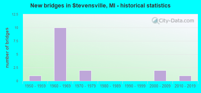
- New bridges - historical statistics
- 11950-1959
- 101960-1969
- 21970-1979
- 22000-2009
- 12010-2019
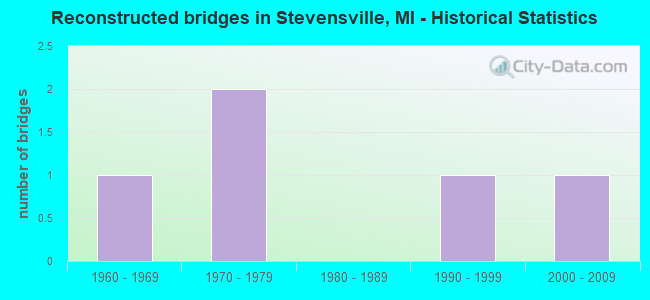
- Reconstructed bridges - Historical Statistics
- 11960-1969
- 21970-1979
- 01980-1989
- 11990-1999
- 12000-2009
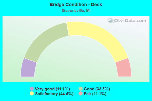
- Bridge Condition - Deck
- 11.1%Very good
- 33.3%Good
- 44.4%Satisfactory
- 11.1%Fair
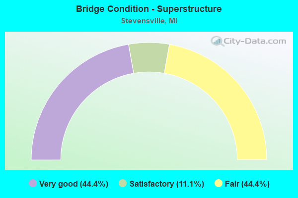
- Bridge Condition - Superstructure
- 44.4%Very good
- 11.1%Satisfactory
- 44.4%Fair
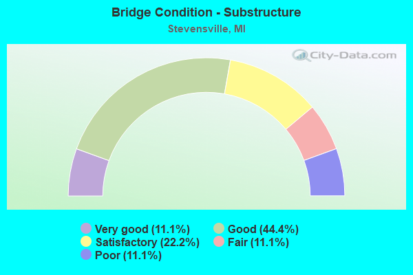
- Bridge Condition - Substructure
- 11.1%Very good
- 44.4%Good
- 22.2%Satisfactory
- 11.1%Fair
- 11.1%Poor
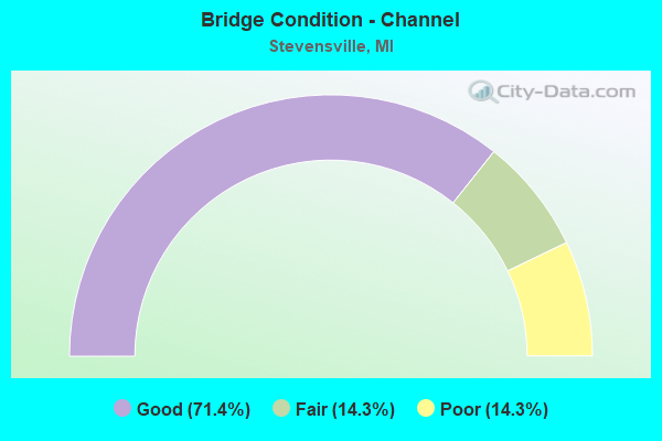
- Bridge Condition - Channel
- 71.4%Good
- 14.3%Fair
- 14.3%Poor
Find on map >> Show street view
Structure Number: 815, Location: W LTS OF STEVENSVILLE (Lat: 42.010625, Lng: -86.532558), Route carried "on" structure: City street , Year Built: 1961, Status: Open, Structure Length: 6.67m (21.88ft), Average Daily Traffic: 2,627 (year 1997), Truck Traffic: 3%, Average Future Daily Traffic: 3,021 (year 2017), Design Load: HS 20+Mod, Features Intersected: I-94, Facility Carried by Structure: JOHN BEERS ROAD
Minimum Vertical Clearance: 30.48m (100.00ft), Kilometerpoint: 1.563, Lanes on structure: 2, Lanes under structure: 6, Owner: State Highway Agency, Approaching Roadway Width: 7.9m (25.9ft), Skew: 1 degrees, Material/Design: Steel, Design/Construction: Stringer/Multi-beam, Number Of Spans In Main Unit: 4, Length of Maximum Span: 21.3m (69.9ft), Curb-To-Curb Width: 9.1m (29.9ft), Out-to-Out Width: 10.0m (32.8ft)
Condition: Deck: Satisfactory, Superstructure: Fair, Substructure: Good, Operating Rating: 69.7 metric tons, Method Used To Determine Operating Rating: Load Factor (LF) rating reported by rating factor (RF) method using MS18 loading, Inventory Rating: 41.8 metric tons, Method Used To Determine Inventory Rating: Load Factor (LF) rating reported by rating factor (RF) method using MS18 loading, Structural Evaluation: Somewhat better than minimum adequacy, Deck Geometry: Meets minimum limits, Underclear: High priority of corrective action, Approach Roadway Alignment: Better than present minimum criteria, Designated Inspection Frequency: Every 24 months, Inspection Date: May 2020, Deck Structure Type: Concrete Cast-file-Place, Wearing Surface/Protective System: Wearing Surface: Latex Concrete
Find on map >> Show street view
Structure Number: 816, Location: N LTS OF STEVENSVILLE (Lat: 42.023150, Lng: -86.528639), Route carried "on" structure: Interstate 94, Year Built: 1961, Year Reconstructed: 1965, Status: Open, Structure Length: 4.71m (15.45ft), Average Daily Traffic: 22,675 (year 2015), Truck Traffic: 30%, Average Future Daily Traffic: 26,325 (year 2035), Design Load: HS 20+Mod, Features Intersected: PUETZ RD
Minimum Vertical Clearance: 30.48m (100.00ft), Kilometerpoint: 36.133, Lanes on structure: 3, Lanes under structure: 2, Base Highway Network: Yes (Inventory Route: 136, Subroute: 4), Owner: State Highway Agency, Approaching Roadway Width: 18.7m (61.4ft), Skew: 3 degrees, Material/Design: Steel, Design/Construction: Stringer/Multi-beam, Number Of Spans In Main Unit: 3, Length of Maximum Span: 16.7m (54.8ft), Curb-To-Curb Width: 17.1m (56.1ft), Out-to-Out Width: 17.9m (58.7ft)
Condition: Deck: Satisfactory, Superstructure: Fair, Substructure: Good, Operating Rating: 97.2 metric tons, Method Used To Determine Operating Rating: Load Factor (LF) rating reported by rating factor (RF) method using MS18 loading, Inventory Rating: 44.4 metric tons, Method Used To Determine Inventory Rating: Load Factor (LF) rating reported by rating factor (RF) method using MS18 loading, Structural Evaluation: Somewhat better than minimum adequacy, Deck Geometry: Equal to present minimum criteria, Underclear: Somewhat better than minimum adequacy, Approach Roadway Alignment: Equal to present desirable criteria, Length Of Structure Improvement: 4.73m (15.52ft), Designated Inspection Frequency: Every 24 months, Inspection Date: May 2020, Bridge Improvement Cost: $119,000, Roadway Improvement Cost: $27,000, Total Project Cost: $322,000, Deck Structure Type: Concrete Cast-file-Place, Wearing Surface/Protective System: Wearing Surface: Latex Concrete, Deck Protection: Epoxy Coated Reinforcing
Find on map >> Show street view
Structure Number: 818, Location: 1.2 MI N OF STEVENSVILLE (Lat: 42.030747, Lng: -86.514258), Route carried "on" structure: Interstate 94, Year Built: 1960, Year Reconstructed: 1978, Status: Open, Structure Length: 5.82m (19.09ft), Average Daily Traffic: 22,145 (year 2007), Truck Traffic: 28%, Average Future Daily Traffic: 31,354 (year 2018), Design Load: HS 20+Mod, Features Intersected: I-94 BL (LAKESHORE DR)
Minimum Vertical Clearance: 30.48m (100.00ft), Kilometerpoint: 37.592, Lanes on structure: 4, Lanes under structure: 5, Base Highway Network: Yes (Inventory Route: 136, Subroute: 4), Owner: State Highway Agency, Approaching Roadway Width: 15.5m (50.9ft), Skew: 13 degrees, Material/Design: Steel, Design/Construction: Stringer/Multi-beam, Number Of Spans In Main Unit: 3, Length of Maximum Span: 30.4m (99.7ft), Curb-To-Curb Width: 29.2m (95.8ft), Out-to-Out Width: 31.1m (102.0ft)
Condition: Deck: Fair, Superstructure: Fair, Substructure: Satisfactory, Operating Rating: 60.3 metric tons, Method Used To Determine Operating Rating: Load Factor (LF) rating reported by rating factor (RF) method using MS18 loading, Inventory Rating: 36.3 metric tons, Method Used To Determine Inventory Rating: Load Factor (LF) rating reported by rating factor (RF) method using MS18 loading, Structural Evaluation: Somewhat better than minimum adequacy, Deck Geometry: Superior to present desirable criteria, Underclear: High priority of corrective action, Approach Roadway Alignment: Equal to present desirable criteria, Designated Inspection Frequency: Every 24 months, Inspection Date: May 2020, Deck Structure Type: Concrete Cast-file-Place, Wearing Surface/Protective System: Wearing Surface: Latex Concrete
Find on map >> Show street view
Structure Number: 819, Location: 1.2 MI N OF STEVENSVILLE (Lat: 42.031067, Lng: -86.514242), Route carried "on" structure: Interstate 94, Year Built: 1960, Year Reconstructed: 1978, Status: Open, Structure Length: 5.85m (19.19ft), Average Daily Traffic: 22,145 (year 2007), Truck Traffic: 28%, Average Future Daily Traffic: 31,354 (year 2018), Design Load: HS 20+Mod, Features Intersected: I-94 BL (LAKESHORE DR)
Minimum Vertical Clearance: 30.48m (100.00ft), Kilometerpoint: 37.636, Lanes on structure: 3, Lanes under structure: 5, Base Highway Network: Yes (Inventory Route: 136, Subroute: 2), Owner: State Highway Agency, Approaching Roadway Width: 17.8m (58.4ft), Skew: 3 degrees, Material/Design: Steel, Design/Construction: Stringer/Multi-beam, Number Of Spans In Main Unit: 3, Length of Maximum Span: 30.4m (99.7ft), Curb-To-Curb Width: 16.1m (52.8ft), Out-to-Out Width: 16.9m (55.4ft)
Condition: Deck: Satisfactory, Superstructure: Fair, Substructure: Satisfactory, Operating Rating: 84.9 metric tons, Method Used To Determine Operating Rating: Load Factor (LF), Inventory Rating: 50.8 metric tons, Method Used To Determine Inventory Rating: Load Factor (LF), Structural Evaluation: Somewhat better than minimum adequacy, Deck Geometry: Equal to present minimum criteria, Underclear: High priority of corrective action, Approach Roadway Alignment: Equal to present desirable criteria, Designated Inspection Frequency: Every 24 months, Inspection Date: May 2020, Deck Structure Type: Concrete Cast-file-Place, Wearing Surface/Protective System: Wearing Surface: Latex Concrete
Find on map >> Show street view
Structure Number: 987, Location: 0.25 MI S OF STEVENSVILLE (Lat: 42.004631, Lng: -86.518397), Route carried "on" structure: County highway 1149, Year Built: 1958, Status: Open, Structure Length: 1.52m (4.99ft), Average Daily Traffic: 2,301 (year 2007), Truck Traffic: 5%, Average Future Daily Traffic: 3,500 (year 2027), Design Load: H 20, Features Intersected: HICKORY CREEK, Facility Carried by Structure: STEVENSVILLE BAROD
Minimum Vertical Clearance: 30.48m (100.00ft), Kilometerpoint: 6.130, Lanes on structure: 2, Owner: County Highway Agency, Approaching Roadway Width: 10.4m (34.1ft), Skew: 1 degrees, Material/Design: Prestressed concrete, Design/Construction: Box Beam or Girders - Multiple, Number Of Spans In Main Unit: 1, Length of Maximum Span: 14.6m (47.9ft), Curb-To-Curb Width: 7.9m (25.9ft), Out-to-Out Width: 10.2m (33.5ft)
Condition: Deck: Satisfactory, Superstructure: Satisfactory, Substructure: Good, Channel: Fair, Operating Rating: 51.5 metric tons, Method Used To Determine Operating Rating: Load Factor (LF) rating reported by rating factor (RF) method using MS18 loading, Inventory Rating: 30.8 metric tons, Method Used To Determine Inventory Rating: Load Factor (LF) rating reported by rating factor (RF) method using MS18 loading, Structural Evaluation: Equal to present minimum criteria, Deck Geometry: High priority of corrective action, Waterway Adequacy: Equal to present minimum criteria, Approach Roadway Alignment: Equal to present desirable criteria, Length Of Structure Improvement: 1.46m (4.79ft), Designated Inspection Frequency: Every 24 months, Inspection Date: June 2020, Bridge Improvement Cost: $13,000, Total Project Cost: $13,000, Deck Structure Type: Other, Wearing Surface/Protective System: Wearing Surface: Bituminous
Find on map >> Show street view
Structure Number: 1016, Location: 1.5 MI NE OF STEVENSVILLE (Lat: 42.028897, Lng: -86.500628), Route carried "on" structure: County highway , Year Built: 1966, Year Reconstructed: 2000, Status: Open, Structure Length: 1.61m (5.28ft), Average Daily Traffic: 4,582 (year 2007), Truck Traffic: 3%, Average Future Daily Traffic: 6,500 (year 2027), Design Load: HS 20+Mod, Features Intersected: HICKORY CREEK, Facility Carried by Structure: MARQUETTE WOODS RD
Minimum Vertical Clearance: 30.48m (100.00ft), Kilometerpoint: 1.188, Lanes on structure: 2, Owner: County Highway Agency, Approaching Roadway Width: 9.8m (32.2ft), Skew: 2 degrees, Material/Design: Wood or Timber, Design/Construction: Slab, Number Of Spans In Main Unit: 2, Length of Maximum Span: 7.9m (25.9ft), Curb-To-Curb Width: 8.5m (27.9ft), Out-to-Out Width: 8.9m (29.2ft)
Condition: Deck: Good, Superstructure: Very good, Substructure: Fair, Channel: Good, Operating Rating: 76.1 metric tons, Method Used To Determine Operating Rating: Allowable Stress (AS) rating reported by rating factor (RF) method using MS18 loading, Inventory Rating: 54.1 metric tons, Method Used To Determine Inventory Rating: Allowable Stress (AS) rating reported by rating factor (RF) method using MS18 loading, Structural Evaluation: Somewhat better than minimum adequacy, Deck Geometry: Meets minimum limits, Waterway Adequacy: Better than present minimum criteria, Approach Roadway Alignment: Better than present minimum criteria, Designated Inspection Frequency: Every 24 months, Inspection Date: June 2020, Deck Structure Type: Wood or Timber, Wearing Surface/Protective System: Wearing Surface: Bituminous
Find on map >> Show street view
Structure Number: 1018, Location: 1 MI NE OF STEVENSVILLE (Lat: 42.025758, Lng: -86.504556), Route carried "on" structure: County highway , Year Built: 1970, Year Reconstructed: 2003, Status: Posted for load, Structure Length: 1.61m (5.28ft), Average Daily Traffic: 2,045 (year 2007), Truck Traffic: 3%, Average Future Daily Traffic: 3,000 (year 2027), Design Load: HS 20, Features Intersected: HICKORY CREEK, Facility Carried by Structure: ROOSEVELT ROAD
Minimum Vertical Clearance: 30.48m (100.00ft), Kilometerpoint: 1.259, Lanes on structure: 2, Owner: County Highway Agency, Approaching Roadway Width: 10.4m (34.1ft), Skew: 3 degrees, Material/Design: Wood or Timber, Design/Construction: Slab, Number Of Spans In Main Unit: 2, Length of Maximum Span: 7.9m (25.9ft), Curb-To-Curb Width: 9.0m (29.5ft), Out-to-Out Width: 9.4m (30.8ft)
Condition: Deck: Good, Superstructure: Very good, Substructure: Poor, Channel: Poor, Operating Rating: 24.3 metric tons, Method Used To Determine Operating Rating: Allowable Stress (AS) rating reported by rating factor (RF) method using MS18 loading, Inventory Rating: 18.5 metric tons, Method Used To Determine Inventory Rating: Allowable Stress (AS) rating reported by rating factor (RF) method using MS18 loading, Structural Evaluation: Meets minimum limits, Deck Geometry: Meets minimum limits, Waterway Adequacy: Equal to present desirable criteria, Approach Roadway Alignment: Somewhat better than minimum adequacy, Bridge Posting: Required (Relationship of Operating Rating to Maximum Legal Load: 30.0 - 39.9% below), Designated Inspection Frequency: Every 12 months, Inspection Date: July 2021, Deck Structure Type: Wood or Timber, Wearing Surface/Protective System: Wearing Surface: Bituminous
Find on map >> Show street view
Structure Number: 12715, Location: VILLAGE OF STEVENSVILLE (Lat: 42.014414, Lng: -86.516625), Route carried "on" structure: Business City street , Year Built: 1977, Status: Open, Structure Length: 1.31m (4.30ft), Average Daily Traffic: 3,800 (year 1996), Truck Traffic: 9%, Average Future Daily Traffic: 4,400 (year 2016), Design Load: HS 20, Features Intersected: HICKORY CREEK, Facility Carried by Structure: JOHNS BEERS ROAD
Minimum Vertical Clearance: 30.48m (100.00ft), Kilometerpoint: 3.169, Lanes on structure: 2, Owner: City or Municipal Highway Agency, Approaching Roadway Width: 12.2m (40.0ft), Material/Design: Steel, Design/Construction: Culvert, Number Of Spans In Main Unit: 2, Length of Maximum Span: 6.1m (20.0ft), Curb or Sidewalk Widths: Left: 1.7m (5.6ft), Right: 1.7m (5.6ft)
Condition: Channel: Good, Culverts: Good, Operating Rating: 79.9 metric tons, Method Used To Determine Operating Rating: Load Factor (LF), Inventory Rating: 47.9 metric tons, Method Used To Determine Inventory Rating: Load Factor (LF), Structural Evaluation: Better than present minimum criteria, Waterway Adequacy: Superior to present desirable criteria, Approach Roadway Alignment: Equal to present desirable criteria, Length Of Structure Improvement: 1.60m (5.25ft), Designated Inspection Frequency: Every 24 months, Inspection Date: October 2020, Bridge Improvement Cost: $300,000, Roadway Improvement Cost: $100,000, Total Project Cost: $520,000
Find on map >> Show street view
Structure Number: 13094, Location: 2 MI S OF STEVENSVILLE (Lat: 41.989700, Lng: -86.524000), Route carried "on" structure: County highway , Year Built: 2007, Status: Open, Structure Length: 1.28m (4.20ft), Average Daily Traffic: 586 (year 2007), Truck Traffic: 4%, Average Future Daily Traffic: 1,200 (year 2027), Design Load: HS 20, Features Intersected: KEELO CREEK, Facility Carried by Structure: JERICHO ROAD
Minimum Vertical Clearance: 30.48m (100.00ft), Kilometerpoint: 4.022, Lanes on structure: 2, Owner: County Highway Agency, Approaching Roadway Width: 9.8m (32.2ft), Skew: 1 degrees, Material/Design: Prestressed concrete, Design/Construction: Box Beam or Girders - Multiple, Number Of Spans In Main Unit: 1, Length of Maximum Span: 11.3m (37.1ft), Curb-To-Curb Width: 9.8m (32.2ft), Out-to-Out Width: 10.5m (34.4ft)
Condition: Deck: Good, Superstructure: Very good, Substructure: Good, Channel: Good, Operating Rating: 93.0 metric tons, Method Used To Determine Operating Rating: Load Factor (LF) rating reported by rating factor (RF) method using MS18 loading, Inventory Rating: 55.7 metric tons, Method Used To Determine Inventory Rating: Load Factor (LF) rating reported by rating factor (RF) method using MS18 loading, Structural Evaluation: Better than present minimum criteria, Deck Geometry: Equal to present minimum criteria, Waterway Adequacy: Equal to present desirable criteria, Approach Roadway Alignment: Equal to present desirable criteria, Designated Inspection Frequency: Every 24 months, Inspection Date: April 2020, Deck Structure Type: Concrete Cast-file-Place, Wearing Surface/Protective System: Wearing Surface: Integral Concrete, Deck Protection: Epoxy Coated Reinforcing
Find on map >> Show street view
Structure Number: 13095, Location: 2 MI S OF STEVENSVILLE (Lat: 41.985475, Lng: -86.524969), Route carried "on" structure: County highway , Year Built: 2009, Status: Open, Structure Length: 0.81m (2.66ft), Average Daily Traffic: 1,192 (year 2007), Truck Traffic: 4%, Average Future Daily Traffic: 1,300 (year 2027), Design Load: HS 20, Features Intersected: KEELO CREEK, Facility Carried by Structure: LINCO ROAD
Minimum Vertical Clearance: 30.48m (100.00ft), Kilometerpoint: 1.159, Lanes on structure: 2, Owner: County Highway Agency, Approaching Roadway Width: 11.0m (36.1ft), Material/Design: Concrete, Design/Construction: Culvert, Number Of Spans In Main Unit: 1, Length of Maximum Span: 7.5m (24.6ft), Curb-To-Curb Width: 11.0m (36.1ft), Out-to-Out Width: 11.4m (37.4ft)
Condition: Channel: Good, Culverts: Good, Operating Rating: 54.5 metric tons, Method Used To Determine Operating Rating: Field evaluation and documented engineering judgment, Inventory Rating: 32.7 metric tons, Method Used To Determine Inventory Rating: Field evaluation and documented engineering judgment, Structural Evaluation: Better than present minimum criteria, Deck Geometry: Equal to present minimum criteria, Waterway Adequacy: Equal to present minimum criteria, Approach Roadway Alignment: Equal to present desirable criteria, Designated Inspection Frequency: Every 24 months, Inspection Date: June 2020
Find on map >> Show street view
Structure Number: 13101, Location: 2 MI S OF STEVENSVILLE (Lat: 41.982694, Lng: -86.523886), Route carried "on" structure: County highway , Year Built: 2014, Status: Open, Structure Length: 1.15m (3.77ft), Average Daily Traffic: 462 (year 2014), Truck Traffic: 4%, Average Future Daily Traffic: 500 (year 2034), Design Load: Greater than HL93, Features Intersected: KEELO CREEK, Facility Carried by Structure: DATE ROAD
Minimum Vertical Clearance: 30.48m (100.00ft), Kilometerpoint: 9.262, Lanes on structure: 2, Owner: County Highway Agency, Approaching Roadway Width: 9.8m (32.2ft), Skew: 3 degrees, Material/Design: Prestressed concrete, Design/Construction: Box Beam or Girders - Multiple, Number Of Spans In Main Unit: 1, Length of Maximum Span: 11.1m (36.4ft), Curb-To-Curb Width: 9.8m (32.2ft), Out-to-Out Width: 10.5m (34.4ft)
Condition: Deck: Very good, Superstructure: Very good, Substructure: Very good, Channel: Good, Operating Rating: 79.7 metric tons, Method Used To Determine Operating Rating: Load and Resistance Factor Rating (LRFR) rating reported by rating factor(RF) method using HL-93 loadings, Inventory Rating: 61.6 metric tons, Method Used To Determine Inventory Rating: Load and Resistance Factor Rating (LRFR) rating reported by rating factor(RF) method using HL-93 loadings, Structural Evaluation: Equal to present desirable criteria, Deck Geometry: Equal to present minimum criteria, Waterway Adequacy: Better than present minimum criteria, Approach Roadway Alignment: Equal to present desirable criteria, Designated Inspection Frequency: Every 24 months, Inspection Date: April 2020, Deck Structure Type: Concrete Cast-file-Place, Wearing Surface/Protective System: Wearing Surface: Monolithic Concrete, Deck Protection: Epoxy Coated Reinforcing
Find on map >> Show street view
Structure Number: 815, Location: W LTS OF STEVENSVILLE (Lat: 42.010625, Lng: -86.532558), Route carried "under" structure: Interstate 94, Year Built: 1961, Structure Length: 0. m, Average Daily Traffic: 37,928 (year 2007), Truck Traffic: 30%, Features Intersected: I-94, Facility Carried by Structure: JOHN BEERS ROAD
Minimum Vertical Clearance: 5.72m (18.77ft), Kilometerpoint: 34.636, Lanes on structure: 2, Lanes under structure: 6, Material/Design: Steel, Design/Construction: Stringer/Multi-beam, Length of Maximum Span: 21.3m (69.9ft)
Find on map >> Show street view
Structure Number: 816, Location: N LTS OF STEVENSVILLE (Lat: 42.023150, Lng: -86.528639), Route carried "under" structure: County highway , Year Built: 1961, Structure Length: 0. m, Average Daily Traffic: 594 (year 1997), Truck Traffic: 3%, Features Intersected: PUETZ RD, Facility Carried by Structure: I-94 EB
Minimum Vertical Clearance: 4.57m (14.99ft), Kilometerpoint: 0.369, Lanes on structure: 3, Lanes under structure: 2, Material/Design: Steel, Design/Construction: Stringer/Multi-beam, Length of Maximum Span: 16.7m (54.8ft)
Find on map >> Show street view
Structure Number: 817, Location: N LTS OF STEVENSVILLE (Lat: 42.023439, Lng: -86.528644), Route carried "under" structure: County highway , Year Built: 1961, Structure Length: 0. m, Average Daily Traffic: 594 (year 1997), Truck Traffic: 3%, Features Intersected: PUETZ RD, Facility Carried by Structure: I-94 WB
Minimum Vertical Clearance: 4.57m (14.99ft), Kilometerpoint: 0.401, Lanes on structure: 3, Lanes under structure: 2, Material/Design: Steel, Design/Construction: Stringer/Multi-beam, Length of Maximum Span: 16.7m (54.8ft)
Find on map >> Show street view
Structure Number: 818, Location: 1.2 MI N OF STEVENSVILLE (Lat: 42.030747, Lng: -86.514258), Route carried "under" structure: Business Interstate 94, Year Built: 1960, Structure Length: 0. m, Average Daily Traffic: 14,734 (year 2007), Truck Traffic: 5%, Features Intersected: I-94 BL (LAKESHORE DR)
Minimum Vertical Clearance: 4.60m (15.09ft), Kilometerpoint: 0.235, Lanes on structure: 4, Lanes under structure: 5, Material/Design: Steel, Design/Construction: Stringer/Multi-beam, Length of Maximum Span: 30.4m (99.7ft)
Find on map >> Show street view
Structure Number: 819, Location: 1.2 MI N OF STEVENSVILLE (Lat: 42.031067, Lng: -86.514242), Route carried "under" structure: Business Interstate 94, Year Built: 1960, Structure Length: 0. m, Average Daily Traffic: 14,734 (year 2007), Truck Traffic: 5%, Features Intersected: I-94 BL (LAKESHORE DR)
Minimum Vertical Clearance: 5.05m (16.57ft), Kilometerpoint: 0.270, Lanes on structure: 3, Lanes under structure: 5, Material/Design: Steel, Design/Construction: Stringer/Multi-beam, Length of Maximum Span: 30.4m (99.7ft)