Bridge Statistics for Story, Wyoming (WY)
Condition, Traffic, Stress, Structural Evaluation, Project Costs
- National Bridge Inventory (NBI) Statistics
- 21Number of bridges
- 144ft / 44.0mTotal length
- $53,000Total costs
- 35,996Total average daily traffic
- 8,808Total average daily truck traffic
- National Bridge Inventory (NBI) Registered Bridges for Story
- No street view available for this location
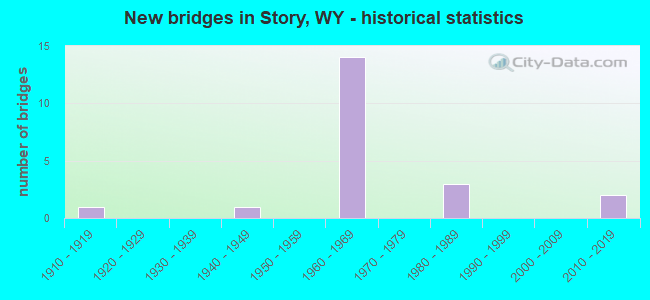
- New bridges - historical statistics
- 11910-1919
- 11940-1949
- 141960-1969
- 31980-1989
- 22010-2019
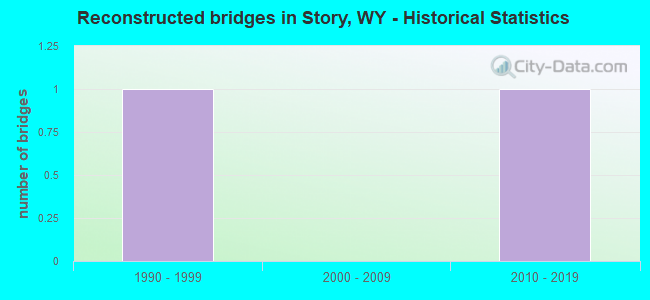
- Reconstructed bridges - Historical Statistics
- 11990-1999
- 02000-2009
- 12010-2019
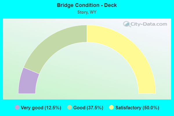
- Bridge Condition - Deck
- 12.5%Very good
- 37.5%Good
- 50.0%Satisfactory
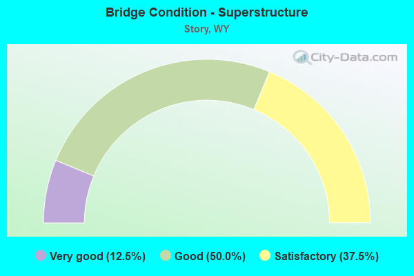
- Bridge Condition - Superstructure
- 12.5%Very good
- 50.0%Good
- 37.5%Satisfactory
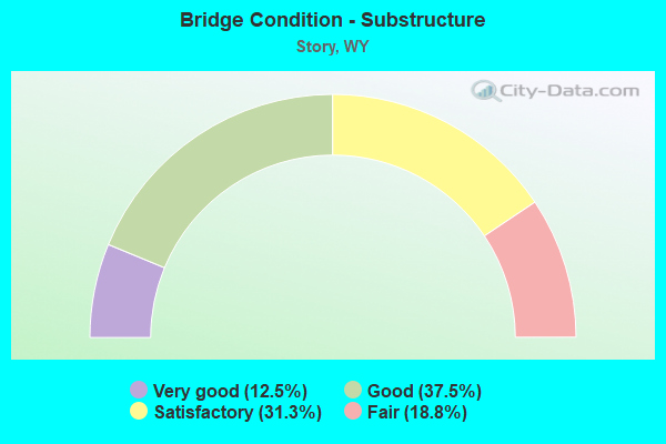
- Bridge Condition - Substructure
- 12.5%Very good
- 37.5%Good
- 31.3%Satisfactory
- 18.8%Fair
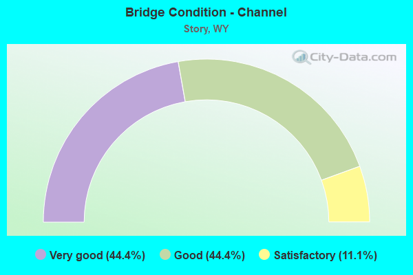
- Bridge Condition - Channel
- 44.4%Very good
- 44.4%Good
- 11.1%Satisfactory
Find on map >> Show street view
Structure Number: BCF, Location: Sheridan - Buffalo (Lat: 44.633508, Lng: -106.857442), Route carried "on" structure: Interstate 90, Year Built: 1968, Status: Open, Structure Length: 4.21m (13.81ft), Average Daily Traffic: 3,500 (year 2021), Truck Traffic: 38%, Average Future Daily Traffic: 4,900 (year 2041), Design Load: HS 20+Mod, Features Intersected: CR 129 / Pompey Creek Rd
Minimum Vertical Clearance: 30+ m (98+ ft), Kilometerpoint: 60.577, Lanes on structure: 2, Lanes under structure: 2, Base Highway Network: Yes (Inventory Route: ML9, Subroute: 1), Owner: State Highway Agency, Approaching Roadway Width: 11.6m (38.1ft), Skew: 10 degrees, Material/Design: Concrete continuous, Design/Construction: Tee Beam, Number Of Spans In Main Unit: 3, Length of Maximum Span: 17.1m (56.1ft), Curb-To-Curb Width: 11.6m (38.1ft), Out-to-Out Width: 12.4m (40.7ft)
Condition: Deck: Good, Superstructure: Satisfactory, Substructure: Good, Operating Rating: 57.2 metric tons, Method Used To Determine Operating Rating: Load Factor (LF), Inventory Rating: 34.5 metric tons, Method Used To Determine Inventory Rating: Load Factor (LF), Structural Evaluation: Equal to present minimum criteria, Deck Geometry: Equal to present minimum criteria, Underclear: Superior to present desirable criteria, Approach Roadway Alignment: Equal to present desirable criteria, Designated Inspection Frequency: Every 24 months, Inspection Date: August 2021, Deck Structure Type: Concrete Cast-file-Place, Wearing Surface/Protective System: Wearing Surface: Latex Concrete
Find on map >> Show street view
Structure Number: BCG, Location: Sheridan - Buffalo (Lat: 44.633683, Lng: -106.856925), Route carried "on" structure: Interstate 90, Year Built: 1968, Status: Open, Structure Length: 4.21m (13.81ft), Average Daily Traffic: 4,096 (year 2021), Truck Traffic: 17%, Average Future Daily Traffic: 5,734 (year 2041), Design Load: HS 20+Mod, Features Intersected: CR 129 / Pompey Creek Rd
Minimum Vertical Clearance: 30+ m (98+ ft), Kilometerpoint: 60.529, Lanes on structure: 2, Lanes under structure: 2, Base Highway Network: Yes (Inventory Route: ML9, Subroute: 1), Owner: State Highway Agency, Approaching Roadway Width: 11.6m (38.1ft), Skew: 10 degrees, Material/Design: Concrete continuous, Design/Construction: Tee Beam, Number Of Spans In Main Unit: 3, Length of Maximum Span: 17.1m (56.1ft), Curb-To-Curb Width: 11.6m (38.1ft), Out-to-Out Width: 12.4m (40.7ft)
Condition: Deck: Good, Superstructure: Good, Substructure: Satisfactory, Operating Rating: 57.2 metric tons, Method Used To Determine Operating Rating: Load Factor (LF), Inventory Rating: 34.5 metric tons, Method Used To Determine Inventory Rating: Load Factor (LF), Structural Evaluation: Equal to present minimum criteria, Deck Geometry: Equal to present minimum criteria, Underclear: High priority of corrective action, Approach Roadway Alignment: Equal to present desirable criteria, Designated Inspection Frequency: Every 24 months, Inspection Date: August 2021, Deck Structure Type: Concrete Cast-file-Place, Wearing Surface/Protective System: Wearing Surface: Latex Concrete
Find on map >> Show street view
Structure Number: BCH, Location: Sheridan - Buffalo (Lat: 44.630256, Lng: -106.855311), Route carried "on" structure: Interstate 90, Year Built: 1968, Status: Open, Structure Length: 2.19m (7.19ft), Average Daily Traffic: 3,650 (year 2021), Truck Traffic: 38%, Average Future Daily Traffic: 5,110 (year 2041), Design Load: HS 20+Mod, Features Intersected: Machinery Pass
Minimum Vertical Clearance: 30+ m (98+ ft), Kilometerpoint: 60.976, Lanes on structure: 2, Base Highway Network: Yes (Inventory Route: ML9, Subroute: 1), Owner: State Highway Agency, Approaching Roadway Width: 11.6m (38.1ft), Skew: 10 degrees, Material/Design: Concrete continuous, Design/Construction: Tee Beam, Number Of Spans In Main Unit: 3, Length of Maximum Span: 8.7m (28.5ft), Curb-To-Curb Width: 11.6m (38.1ft), Out-to-Out Width: 12.4m (40.7ft)
Condition: Deck: Satisfactory, Superstructure: Good, Substructure: Fair, Operating Rating: 47.2 metric tons, Method Used To Determine Operating Rating: Load Factor (LF), Inventory Rating: 28.1 metric tons, Method Used To Determine Inventory Rating: Load Factor (LF), Structural Evaluation: Somewhat better than minimum adequacy, Deck Geometry: Equal to present minimum criteria, Approach Roadway Alignment: Equal to present desirable criteria, Designated Inspection Frequency: Every 24 months, Inspection Date: August 2021, Deck Structure Type: Concrete Cast-file-Place, Wearing Surface/Protective System: Wearing Surface: Latex Concrete
Find on map >> Show street view
Structure Number: BCI, Location: Sheridan - Buffalo (Lat: 44.630422, Lng: -106.854797), Route carried "on" structure: Interstate 90, Year Built: 1968, Status: Open, Structure Length: 2.19m (7.19ft), Average Daily Traffic: 4,096 (year 2021), Truck Traffic: 17%, Average Future Daily Traffic: 5,734 (year 2041), Design Load: HS 20+Mod, Features Intersected: Machinery Pass
Minimum Vertical Clearance: 30+ m (98+ ft), Kilometerpoint: 60.928, Lanes on structure: 2, Base Highway Network: Yes (Inventory Route: ML9, Subroute: 1), Owner: State Highway Agency, Approaching Roadway Width: 11.6m (38.1ft), Skew: 10 degrees, Material/Design: Concrete continuous, Design/Construction: Tee Beam, Number Of Spans In Main Unit: 3, Length of Maximum Span: 8.7m (28.5ft), Curb-To-Curb Width: 11.6m (38.1ft), Out-to-Out Width: 12.4m (40.7ft)
Condition: Deck: Satisfactory, Superstructure: Good, Substructure: Fair, Operating Rating: 47.2 metric tons, Method Used To Determine Operating Rating: Load Factor (LF), Inventory Rating: 28.1 metric tons, Method Used To Determine Inventory Rating: Load Factor (LF), Structural Evaluation: Somewhat better than minimum adequacy, Deck Geometry: Equal to present minimum criteria, Approach Roadway Alignment: Equal to present desirable criteria, Designated Inspection Frequency: Every 24 months, Inspection Date: August 2021, Deck Structure Type: Concrete Cast-file-Place, Wearing Surface/Protective System: Wearing Surface: Latex Concrete
Find on map >> Show street view
Structure Number: BCJ, Location: Sheridan - Buffalo (Lat: 44.619497, Lng: -106.849056), Route carried "on" structure: Interstate 90, Year Built: 1968, Status: Open, Structure Length: 4.21m (13.81ft), Average Daily Traffic: 3,650 (year 2021), Truck Traffic: 38%, Average Future Daily Traffic: 5,110 (year 2041), Design Load: HS 20+Mod, Features Intersected: Upper Prairie Dog Road
Minimum Vertical Clearance: 30+ m (98+ ft), Kilometerpoint: 62.270, Lanes on structure: 2, Lanes under structure: 2, Base Highway Network: Yes (Inventory Route: ML9, Subroute: 1), Owner: State Highway Agency, Approaching Roadway Width: 11.6m (38.1ft), Skew: 2 degrees, Material/Design: Concrete continuous, Design/Construction: Tee Beam, Number Of Spans In Main Unit: 3, Length of Maximum Span: 17.1m (56.1ft), Curb-To-Curb Width: 11.6m (38.1ft), Out-to-Out Width: 12.4m (40.7ft)
Condition: Deck: Satisfactory, Superstructure: Satisfactory, Substructure: Good, Operating Rating: 56.2 metric tons, Method Used To Determine Operating Rating: Load Factor (LF), Inventory Rating: 33.6 metric tons, Method Used To Determine Inventory Rating: Load Factor (LF), Structural Evaluation: Equal to present minimum criteria, Deck Geometry: Equal to present minimum criteria, Underclear: Equal to present minimum criteria, Approach Roadway Alignment: Equal to present desirable criteria, Designated Inspection Frequency: Every 24 months, Inspection Date: August 2021, Deck Structure Type: Concrete Cast-file-Place, Wearing Surface/Protective System: Wearing Surface: Latex Concrete
Find on map >> Show street view
Structure Number: BCK, Location: Sheridan - Buffalo (Lat: 44.619517, Lng: -106.848428), Route carried "on" structure: Interstate 90, Year Built: 1968, Status: Open, Structure Length: 4.21m (13.81ft), Average Daily Traffic: 4,096 (year 2021), Truck Traffic: 17%, Average Future Daily Traffic: 5,734 (year 2041), Design Load: HS 20+Mod, Features Intersected: Upper Prairie Dog Road
Minimum Vertical Clearance: 30+ m (98+ ft), Kilometerpoint: 62.241, Lanes on structure: 2, Lanes under structure: 2, Base Highway Network: Yes (Inventory Route: ML9, Subroute: 1), Owner: State Highway Agency, Approaching Roadway Width: 11.6m (38.1ft), Skew: 2 degrees, Material/Design: Concrete continuous, Design/Construction: Tee Beam, Number Of Spans In Main Unit: 3, Length of Maximum Span: 17.1m (56.1ft), Curb-To-Curb Width: 11.6m (38.1ft), Out-to-Out Width: 12.4m (40.7ft)
Condition: Deck: Good, Superstructure: Satisfactory, Substructure: Satisfactory, Operating Rating: 56.2 metric tons, Method Used To Determine Operating Rating: Load Factor (LF), Inventory Rating: 33.6 metric tons, Method Used To Determine Inventory Rating: Load Factor (LF), Structural Evaluation: Equal to present minimum criteria, Deck Geometry: Equal to present minimum criteria, Underclear: Equal to present minimum criteria, Approach Roadway Alignment: Equal to present desirable criteria, Designated Inspection Frequency: Every 24 months, Inspection Date: August 2021, Deck Structure Type: Concrete Cast-file-Place, Wearing Surface/Protective System: Wearing Surface: Latex Concrete
Find on map >> Show street view
Structure Number: BCL, Location: Sheridan - Buffalo (Lat: 44.613753, Lng: -106.847000), Route carried "on" structure: Interstate 90, Year Built: 1968, Year Reconstructed: 2002, Status: Open, Structure Length: 2.32m (7.61ft), Average Daily Traffic: 3,794 (year 2021), Truck Traffic: 38%, Average Future Daily Traffic: 5,312 (year 2041), Design Load: HS 20+Mod, Features Intersected: Machinery Pass
Minimum Vertical Clearance: 30+ m (98+ ft), Kilometerpoint: 62.932, Lanes on structure: 2, Base Highway Network: Yes (Inventory Route: ML9, Subroute: 1), Owner: State Highway Agency, Approaching Roadway Width: 13.4m (44.0ft), Skew: 10 degrees, Material/Design: Concrete continuous, Design/Construction: Tee Beam, Number Of Spans In Main Unit: 3, Length of Maximum Span: 9.4m (30.8ft), Curb-To-Curb Width: 13.4m (44.0ft), Out-to-Out Width: 14.4m (47.2ft)
Condition: Deck: Good, Superstructure: Good, Substructure: Good, Operating Rating: 47.2 metric tons, Method Used To Determine Operating Rating: Load Factor (LF), Inventory Rating: 28.1 metric tons, Method Used To Determine Inventory Rating: Load Factor (LF), Structural Evaluation: Better than present minimum criteria, Deck Geometry: Superior to present desirable criteria, Approach Roadway Alignment: Equal to present desirable criteria, Designated Inspection Frequency: Every 24 months, Inspection Date: August 2021, Deck Structure Type: Concrete Cast-file-Place, Wearing Surface/Protective System: Wearing Surface: Latex Concrete
Find on map >> Show street view
Structure Number: BCM, Location: Sheridan - Buffalo (Lat: 44.613778, Lng: -106.846425), Route carried "on" structure: Interstate 90, Year Built: 1968, Status: Open, Structure Length: 2.32m (7.61ft), Average Daily Traffic: 4,025 (year 2021), Truck Traffic: 17%, Average Future Daily Traffic: 5,635 (year 2041), Design Load: HS 20+Mod, Features Intersected: Machinery Pass
Minimum Vertical Clearance: 30+ m (98+ ft), Kilometerpoint: 62.903, Lanes on structure: 2, Base Highway Network: Yes (Inventory Route: ML9, Subroute: 1), Owner: State Highway Agency, Approaching Roadway Width: 11.6m (38.1ft), Skew: 10 degrees, Material/Design: Concrete continuous, Design/Construction: Tee Beam, Number Of Spans In Main Unit: 3, Length of Maximum Span: 9.4m (30.8ft), Curb-To-Curb Width: 11.6m (38.1ft), Out-to-Out Width: 12.4m (40.7ft)
Condition: Deck: Satisfactory, Superstructure: Good, Substructure: Good, Operating Rating: 47.2 metric tons, Method Used To Determine Operating Rating: Load Factor (LF), Inventory Rating: 28.1 metric tons, Method Used To Determine Inventory Rating: Load Factor (LF), Structural Evaluation: Better than present minimum criteria, Deck Geometry: Equal to present minimum criteria, Approach Roadway Alignment: Equal to present desirable criteria, Designated Inspection Frequency: Every 24 months, Inspection Date: August 2021, Deck Structure Type: Concrete Cast-file-Place, Wearing Surface/Protective System: Wearing Surface: Epoxy Overlay, Membrane: Preformed Fabric
Find on map >> Show street view
Structure Number: BKG, Location: 2 Miles W. Of Storey (Lat: 44.579842, Lng: -106.932228), Route carried "on" structure: County highway 2, Year Built: 1914, Status: Open, Structure Length: 1.22m (4.00ft), Average Daily Traffic: 150 (year 2021), Truck Traffic: 10%, Average Future Daily Traffic: 210 (year 2041), Features Intersected: North Piney Creek
Minimum Vertical Clearance: 30+ m (98+ ft), Kilometerpoint: 1.767, Lanes on structure: 1, Owner: County Highway Agency, Approaching Roadway Width: 5.2m (17.1ft), Material/Design: Steel, Design/Construction: Stringer/Multi-beam, Number Of Spans In Main Unit: 1, Length of Maximum Span: 11.6m (38.1ft), Curb-To-Curb Width: 4.2m (13.8ft), Out-to-Out Width: 4.9m (16.1ft)
Condition: Deck: Good, Superstructure: Satisfactory, Substructure: Good, Channel: Good, Operating Rating: 89.8 metric tons, Method Used To Determine Operating Rating: Allowable Stress (AS), Inventory Rating: 55.3 metric tons, Method Used To Determine Inventory Rating: Allowable Stress (AS), Structural Evaluation: Equal to present minimum criteria, Deck Geometry: High priority of replacement, Waterway Adequacy: Better than present minimum criteria, Approach Roadway Alignment: High priority of corrective action, Length Of Structure Improvement: 5.79m (19.00ft), Designated Inspection Frequency: Every 24 months, Inspection Date: April 2020, Bridge Improvement Cost: $8,000, Roadway Improvement Cost: $30,000, Total Project Cost: $39,000 ( Estimate for 2014), Deck Structure Type: Corrugated Steel, Wearing Surface/Protective System: Wearing Surface: Bituminous
Find on map >> Show street view
Structure Number: BMW, Location: Story - West (Lat: 44.572289, Lng: -106.893758), Route carried "on" structure: State highway 194, Year Built: 1962, Status: Open, Structure Length: 1.04m (3.41ft), Average Daily Traffic: 650 (year 2021), Truck Traffic: 10%, Average Future Daily Traffic: 910 (year 2041), Design Load: H 20, Features Intersected: Prairie Dog Creek Ditch
Minimum Vertical Clearance: 30+ m (98+ ft), Kilometerpoint: 1.716, Lanes on structure: 2, Owner: State Highway Agency, Approaching Roadway Width: 9.1m (29.9ft), Skew: 6 degrees, Material/Design: Concrete, Design/Construction: Frame, Number Of Spans In Main Unit: 1, Length of Maximum Span: 7.6m (24.9ft), Curb or Sidewalk Widths: Left: 1.1m (3.6ft), Right: 1.1m (3.6ft), Curb-To-Curb Width: 9.1m (29.9ft), Out-to-Out Width: 11.3m (37.1ft)
Condition: Deck: Satisfactory, Superstructure: Satisfactory, Substructure: Satisfactory, Channel: Good, Operating Rating: 33.6 metric tons, Method Used To Determine Operating Rating: Load Factor (LF), Inventory Rating: 20.0 metric tons, Method Used To Determine Inventory Rating: Load Factor (LF), Structural Evaluation: Somewhat better than minimum adequacy, Deck Geometry: Equal to present minimum criteria, Waterway Adequacy: Equal to present desirable criteria, Approach Roadway Alignment: Equal to present desirable criteria, Designated Inspection Frequency: Every 24 months, Inspection Date: July 2020, Deck Structure Type: Concrete Cast-file-Place, Wearing Surface/Protective System: Wearing Surface: Bituminous
Find on map >> Show street view
Structure Number: CQO, Location: Story - West (Lat: 44.576825, Lng: -106.884942), Route carried "on" structure: State highway 194, Year Built: 1962, Status: Open, Structure Length: 1.04m (3.41ft), Average Daily Traffic: 1,548 (year 2021), Truck Traffic: 10%, Average Future Daily Traffic: 2,167 (year 2041), Design Load: HS 20, Features Intersected: Prairie Dog Creek Ditch
Minimum Vertical Clearance: 30+ m (98+ ft), Kilometerpoint: 0.541, Lanes on structure: 2, Owner: State Highway Agency, Approaching Roadway Width: 13.0m (42.7ft), Skew: 6 degrees, Material/Design: Concrete, Design/Construction: Slab, Number Of Spans In Main Unit: 1, Length of Maximum Span: 9.8m (32.2ft), Curb or Sidewalk Widths: Left: 1.1m (3.6ft), Right: 1.1m (3.6ft), Curb-To-Curb Width: 13.0m (42.7ft), Out-to-Out Width: 15.1m (49.5ft)
Condition: Deck: Satisfactory, Superstructure: Satisfactory, Substructure: Fair, Channel: Good, Operating Rating: 31.8 metric tons, Method Used To Determine Operating Rating: Load Factor (LF), Inventory Rating: 19.1 metric tons, Method Used To Determine Inventory Rating: Load Factor (LF), Structural Evaluation: Somewhat better than minimum adequacy, Deck Geometry: Better than present minimum criteria, Waterway Adequacy: Equal to present desirable criteria, Approach Roadway Alignment: Equal to present desirable criteria, Designated Inspection Frequency: Every 24 months, Inspection Date: July 2020, Deck Structure Type: Concrete Cast-file-Place, Wearing Surface/Protective System: Wearing Surface: Bituminous
Find on map >> Show street view
Structure Number: FDN, Location: Story (Lat: 44.570933, Lng: -106.890722), Route carried "on" structure: County highway 145, Year Built: 1986, Status: Open, Structure Length: 1.83m (6.00ft), Average Daily Traffic: 401 (year 2021), Truck Traffic: 10%, Average Future Daily Traffic: 561 (year 2041), Design Load: HS 20, Features Intersected: South Piney Creek
Minimum Vertical Clearance: 30+ m (98+ ft), Kilometerpoint: 0.203, Lanes on structure: 2, Owner: County Highway Agency, Approaching Roadway Width: 7.9m (25.9ft), Skew: 1 degrees, Material/Design: Steel, Design/Construction: Stringer/Multi-beam, Number Of Spans In Main Unit: 1, Length of Maximum Span: 17.4m (57.1ft), Curb-To-Curb Width: 7.9m (25.9ft), Out-to-Out Width: 8.7m (28.5ft)
Condition: Deck: Good, Superstructure: Good, Substructure: Good, Channel: Very good, Operating Rating: 70.8 metric tons, Method Used To Determine Operating Rating: Allowable Stress (AS), Inventory Rating: 42.6 metric tons, Method Used To Determine Inventory Rating: Allowable Stress (AS), Structural Evaluation: Better than present minimum criteria, Deck Geometry: Somewhat better than minimum adequacy, Waterway Adequacy: Equal to present desirable criteria, Approach Roadway Alignment: Equal to present desirable criteria, Designated Inspection Frequency: Every 24 months, Inspection Date: April 2020, Deck Structure Type: Concrete Cast-file-Place, Wearing Surface/Protective System: Deck Protection: Epoxy Coated Reinforcing
Find on map >> Show street view
Structure Number: FFA, Location: Banner-Story (Lat: 44.569722, Lng: -106.876556), Route carried "on" structure: State highway 193, Year Built: 1986, Status: Open, Structure Length: 1.52m (4.99ft), Average Daily Traffic: 113 (year 2021), Truck Traffic: 10%, Average Future Daily Traffic: 158 (year 2041), Design Load: HS 20, Features Intersected: South Piney Creek
Minimum Vertical Clearance: 30+ m (98+ ft), Kilometerpoint: 166.670, Lanes on structure: 2, Owner: State Highway Agency, Approaching Roadway Width: 11.0m (36.1ft), Material/Design: Steel, Design/Construction: Stringer/Multi-beam, Number Of Spans In Main Unit: 1, Length of Maximum Span: 14.6m (47.9ft), Curb-To-Curb Width: 11.0m (36.1ft), Out-to-Out Width: 11.8m (38.7ft)
Condition: Deck: Satisfactory, Superstructure: Good, Substructure: Satisfactory, Channel: Satisfactory, Operating Rating: 54.4 metric tons, Method Used To Determine Operating Rating: Load Factor (LF), Inventory Rating: 32.7 metric tons, Method Used To Determine Inventory Rating: Load Factor (LF), Structural Evaluation: Equal to present minimum criteria, Deck Geometry: Equal to present desirable criteria, Waterway Adequacy: Equal to present desirable criteria, Approach Roadway Alignment: Better than present minimum criteria, Designated Inspection Frequency: Every 24 months, Inspection Date: July 2020, Deck Structure Type: Concrete Cast-file-Place, Wearing Surface/Protective System: Wearing Surface: Epoxy Overlay
Find on map >> Show street view
Structure Number: FFB, Location: Banner-Story (Lat: 44.575342, Lng: -106.879058), Route carried "on" structure: State highway 193, Year Built: 1986, Status: Open, Structure Length: 1.77m (5.81ft), Average Daily Traffic: 113 (year 2021), Truck Traffic: 10%, Average Future Daily Traffic: 158 (year 2041), Design Load: HS 20, Features Intersected: North Piney Creek
Minimum Vertical Clearance: 30+ m (98+ ft), Kilometerpoint: 167.335, Lanes on structure: 2, Owner: State Highway Agency, Approaching Roadway Width: 11.0m (36.1ft), Skew: 3 degrees, Material/Design: Steel, Design/Construction: Stringer/Multi-beam, Number Of Spans In Main Unit: 1, Length of Maximum Span: 16.8m (55.1ft), Curb-To-Curb Width: 11.0m (36.1ft), Out-to-Out Width: 11.7m (38.4ft)
Condition: Deck: Satisfactory, Superstructure: Good, Substructure: Satisfactory, Channel: Very good, Operating Rating: 57.2 metric tons, Method Used To Determine Operating Rating: Load Factor (LF), Inventory Rating: 33.6 metric tons, Method Used To Determine Inventory Rating: Load Factor (LF), Structural Evaluation: Equal to present minimum criteria, Deck Geometry: Equal to present desirable criteria, Waterway Adequacy: Superior to present desirable criteria, Approach Roadway Alignment: Equal to present desirable criteria, Designated Inspection Frequency: Every 24 months, Inspection Date: July 2020, Deck Structure Type: Concrete Cast-file-Place, Wearing Surface/Protective System: Wearing Surface: Epoxy Overlay
Find on map >> Show street view
Structure Number: IHW, Location: Sheridan-Buffalo (Lat: 44.529022, Lng: -106.810272), Route carried "on" structure: State highway 193, Year Built: 1947, Year Reconstructed: 2017, Status: Open, Structure Length: 0.72m (2.36ft), Average Daily Traffic: 620 (year 2021), Truck Traffic: 10%, Average Future Daily Traffic: 868 (year 2041), Features Intersected: Little Piney Creek
Minimum Vertical Clearance: 30+ m (98+ ft), Kilometerpoint: 159.444, Lanes on structure: 2, Owner: State Highway Agency, Approaching Roadway Width: 9.5m (31.2ft), Skew: 4 degrees, Material/Design: Concrete, Design/Construction: Culvert, Number Of Spans In Main Unit: 2, Length of Maximum Span: 2.4m (7.9ft)
Condition: Channel: Good, Culverts: Good, Operating Rating: 54.5 metric tons, Method Used To Determine Operating Rating: Field evaluation and documented engineering judgment, Inventory Rating: 32.7 metric tons, Method Used To Determine Inventory Rating: Field evaluation and documented engineering judgment, Structural Evaluation: Better than present minimum criteria, Waterway Adequacy: Equal to present desirable criteria, Approach Roadway Alignment: Equal to present desirable criteria, Designated Inspection Frequency: Every 24 months, Inspection Date: Febuary 2022
Find on map >> Show street view
Structure Number: MXI, Location: Jct I-90 - Story (Lat: 44.535461, Lng: -106.816842), Route carried "on" structure: State highway 193, Year Built: 2017, Status: Open, Structure Length: 5.49m (18.01ft), Average Daily Traffic: 620 (year 2021), Truck Traffic: 10%, Average Future Daily Traffic: 868 (year 2041), Design Load: HL 93, Features Intersected: Piney Creek
Minimum Vertical Clearance: 30+ m (98+ ft), Kilometerpoint: 160.329, Lanes on structure: 2, Owner: State Highway Agency, Approaching Roadway Width: 9.1m (29.9ft), Skew: 4 degrees, Material/Design: Steel continuous, Design/Construction: Stringer/Multi-beam, Number Of Spans In Main Unit: 3, Length of Maximum Span: 23.5m (77.1ft), Curb-To-Curb Width: 9.1m (29.9ft), Out-to-Out Width: 10.2m (33.5ft)
Condition: Deck: Very good, Superstructure: Very good, Substructure: Very good, Channel: Very good, Operating Rating: 56.4 metric tons, Method Used To Determine Operating Rating: Load and Resistance Factor Rating (LRFR) rating reported by rating factor(RF) method using HL-93 loadings, Inventory Rating: 43.4 metric tons, Method Used To Determine Inventory Rating: Load and Resistance Factor Rating (LRFR) rating reported by rating factor(RF) method using HL-93 loadings, Structural Evaluation: Equal to present desirable criteria, Deck Geometry: Equal to present minimum criteria, Waterway Adequacy: Equal to present desirable criteria, Approach Roadway Alignment: Equal to present desirable criteria, Length Of Structure Improvement: 0.30m (0.98ft), Designated Inspection Frequency: Every 24 months, Inspection Date: Febuary 2020, Bridge Improvement Cost: $5,000, Roadway Improvement Cost: $1,000, Total Project Cost: $7,000 ( Estimate for 2015), Deck Structure Type: Concrete Cast-file-Place, Wearing Surface/Protective System: Deck Protection: Epoxy Coated Reinforcing
Find on map >> Show street view
Structure Number: MXK, Location: Jct I-90 - Story (Lat: 44.539758, Lng: -106.823814), Route carried "on" structure: State highway 193, Year Built: 2017, Status: Open, Structure Length: 3.51m (11.52ft), Average Daily Traffic: 630 (year 2021), Truck Traffic: 10%, Average Future Daily Traffic: 882 (year 2041), Design Load: HL 93, Features Intersected: Piney Creek
Minimum Vertical Clearance: 30+ m (98+ ft), Kilometerpoint: 161.107, Lanes on structure: 2, Owner: State Highway Agency, Approaching Roadway Width: 12.5m (41.0ft), Skew: 4 degrees, Material/Design: Steel continuous, Design/Construction: Stringer/Multi-beam, Number Of Spans In Main Unit: 3, Length of Maximum Span: 13.7m (44.9ft), Curb-To-Curb Width: 12.5m (41.0ft), Out-to-Out Width: 13.5m (44.3ft)
Condition: Deck: Very good, Superstructure: Very good, Substructure: Very good, Channel: Very good, Operating Rating: 55.1 metric tons, Method Used To Determine Operating Rating: Load and Resistance Factor Rating (LRFR) rating reported by rating factor(RF) method using HL-93 loadings, Inventory Rating: 42.1 metric tons, Method Used To Determine Inventory Rating: Load and Resistance Factor Rating (LRFR) rating reported by rating factor(RF) method using HL-93 loadings, Structural Evaluation: Equal to present desirable criteria, Deck Geometry: Superior to present desirable criteria, Waterway Adequacy: Equal to present desirable criteria, Approach Roadway Alignment: Equal to present minimum criteria, Length Of Structure Improvement: 0.30m (0.98ft), Designated Inspection Frequency: Every 24 months, Inspection Date: Febuary 2022, Bridge Improvement Cost: $5,000, Roadway Improvement Cost: $1,000, Total Project Cost: $7,000 ( Estimate for 2015), Deck Structure Type: Concrete Cast-file-Place, Wearing Surface/Protective System: Deck Protection: Epoxy Coated Reinforcing
Find on map >> Show street view
Structure Number: BCF, Location: Sheridan - Buffalo (Lat: 44.633508, Lng: -106.857442), Route carried "under" structure: County highway 129, Year Built: 1968, Structure Length: 0. m, Average Daily Traffic: 42 (year 2021), Truck Traffic: 3%, Features Intersected: CR 129 / Pompey Creek Rd, Facility Carried by Structure: I-90 EBL
Minimum Vertical Clearance: 6.17m (20.24ft), Kilometerpoint: 1.645, Lanes on structure: 2, Lanes under structure: 2, Material/Design: Concrete continuous, Design/Construction: Tee Beam, Length of Maximum Span: 17.1m (56.1ft)
Find on map >> Show street view
Structure Number: BCG, Location: Sheridan - Buffalo (Lat: 44.633683, Lng: -106.856925), Route carried "under" structure: County highway 129, Year Built: 1968, Structure Length: 0. m, Average Daily Traffic: 42 (year 2021), Truck Traffic: 3%, Features Intersected: CR 129 / Pompey Creek Rd, Facility Carried by Structure: I-90 WBL
Minimum Vertical Clearance: 6.10m (20.01ft), Kilometerpoint: 1.691, Lanes on structure: 2, Lanes under structure: 2, Material/Design: Concrete continuous, Design/Construction: Tee Beam, Length of Maximum Span: 17.1m (56.1ft)
Find on map >> Show street view
Structure Number: BCJ, Location: Sheridan - Buffalo (Lat: 44.619497, Lng: -106.849056), Route carried "under" structure: County highway 127, Year Built: 1968, Structure Length: 0. m, Average Daily Traffic: 80 (year 2021), Truck Traffic: 4%, Features Intersected: Upper Prairie Dog Road, Facility Carried by Structure: I-90 EBL
Minimum Vertical Clearance: 4.67m (15.32ft), Kilometerpoint: 2.773, Lanes on structure: 2, Lanes under structure: 2, Material/Design: Concrete continuous, Design/Construction: Tee Beam, Length of Maximum Span: 17.1m (56.1ft)
Find on map >> Show street view
Structure Number: BCK, Location: Sheridan - Buffalo (Lat: 44.619517, Lng: -106.848428), Route carried "under" structure: County highway 127, Year Built: 1968, Structure Length: 0. m, Average Daily Traffic: 80 (year 2021), Truck Traffic: 4%, Features Intersected: Upper Prairie Dog Road, Facility Carried by Structure: I-90 WBL
Minimum Vertical Clearance: 5.13m (16.83ft), Kilometerpoint: 2.824, Lanes on structure: 2, Lanes under structure: 2, Material/Design: Concrete continuous, Design/Construction: Tee Beam, Length of Maximum Span: 17.1m (56.1ft)