Bridge Statistics for Stowe, Pennsylvania (PA)
Condition, Traffic, Stress, Structural Evaluation, Project Costs
- National Bridge Inventory (NBI) Statistics
- 12Number of bridges
- 89ft / 27.2mTotal length
- $2,276,000Total costs
- 88,470Total average daily traffic
- 7,350Total average daily truck traffic
- National Bridge Inventory (NBI) Registered Bridges for Stowe
- No street view available for this location
- New bridges - historical statistics
- 11900-1909
- 11910-1919
- 11920-1929
- 11930-1939
- 11940-1949
- 21960-1969
- 11990-1999
- 42010-2019
- Reconstructed bridges - Historical Statistics
- 11980-1989
- 11990-1999
- 02000-2009
- 12010-2019
- Bridge Condition - Deck
- 28.6%Excellent
- 28.6%Good
- 14.3%Satisfactory
- 14.3%Fair
- 14.3%Poor
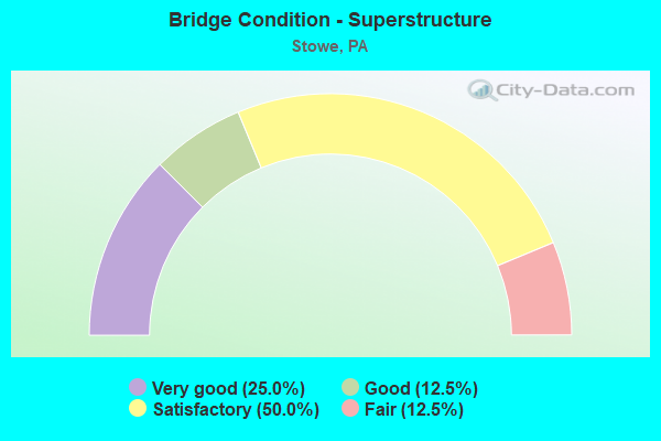
- Bridge Condition - Superstructure
- 25.0%Very good
- 12.5%Good
- 50.0%Satisfactory
- 12.5%Fair
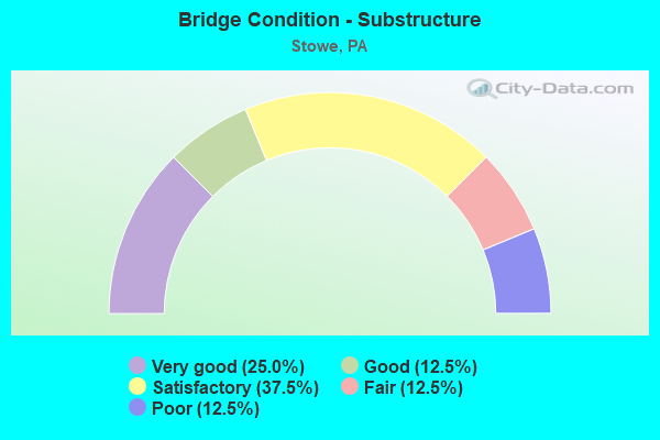
- Bridge Condition - Substructure
- 25.0%Very good
- 12.5%Good
- 37.5%Satisfactory
- 12.5%Fair
- 12.5%Poor
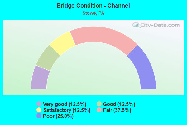
- Bridge Condition - Channel
- 12.5%Very good
- 12.5%Good
- 12.5%Satisfactory
- 37.5%Fair
- 25.0%Poor
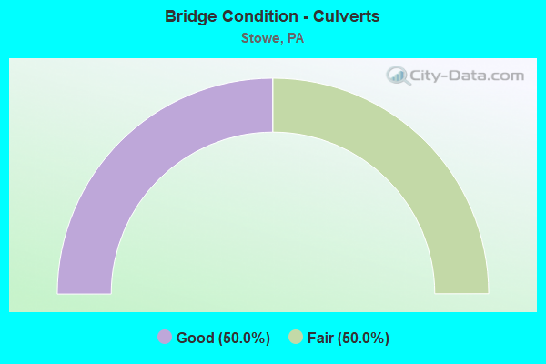
- Bridge Condition - Culverts
- 50.0%Good
- 50.0%Fair
Find on map >> Show street view
Structure Number: 4875, Location: MONTGOMERY COUNTY LINE (Lat: 40.242392, Lng: -75.696258), Route carried "on" structure: US 422, Year Built: 1967, Status: Open, Structure Length: 0.67m (2.20ft), Average Daily Traffic: 32,428 (year 2022), Truck Traffic: 9%, Average Future Daily Traffic: 47,430 (year 2032), Design Load: HS 20, Features Intersected: TRIB.TO SCHUYLKILL RIVER
Minimum Vertical Clearance: 30+ m (98+ ft), Kilometerpoint: 52.358, Lanes on structure: 4, Base Highway Network: Yes, Owner: State Highway Agency, Approaching Roadway Width: 26.8m (87.9ft), Skew: 20 degrees, Material/Design: Concrete, Design/Construction: Culvert, Number Of Spans In Main Unit: 1, Length of Maximum Span: 6.7m (22.0ft)
Condition: Channel: Fair, Culverts: Good, Operating Rating: 89.8 metric tons, Method Used To Determine Operating Rating: Field evaluation and documented engineering judgment, Inventory Rating: 32.7 metric tons, Method Used To Determine Inventory Rating: Field evaluation and documented engineering judgment, Structural Evaluation: Better than present minimum criteria, Waterway Adequacy: Superior to present desirable criteria, Approach Roadway Alignment: Equal to present desirable criteria, Length Of Structure Improvement: 1.30m (4.27ft), Designated Inspection Frequency: Every 24 months, Inspection Date: January 2021, Bridge Improvement Cost: $58,000, Roadway Improvement Cost: $172,000, Total Project Cost: $786,000
Find on map >> Show street view
Structure Number: 4917, Location: NEAR CHESTER COUNTY LINE (Lat: 40.243053, Lng: -75.701839), Route carried "on" structure: State highway 724, Year Built: 1949, Status: Open, Structure Length: 0.61m (2.00ft), Average Daily Traffic: 7,757 (year 2022), Truck Traffic: 9%, Average Future Daily Traffic: 7,674 (year 2032), Design Load: HS 20, Features Intersected: TRIB SCHUYLKILL RIV
Minimum Vertical Clearance: 30+ m (98+ ft), Kilometerpoint: 28.485, Lanes on structure: 2, Owner: State Highway Agency, Approaching Roadway Width: 9.1m (29.9ft), Material/Design: Concrete, Design/Construction: Culvert, Number Of Spans In Main Unit: 1, Length of Maximum Span: 6.1m (20.0ft)
Condition: Channel: Poor, Culverts: Fair, Operating Rating: 89.8 metric tons, Method Used To Determine Operating Rating: Field evaluation and documented engineering judgment, Inventory Rating: 89.8 metric tons, Method Used To Determine Inventory Rating: Field evaluation and documented engineering judgment, Structural Evaluation: Somewhat better than minimum adequacy, Waterway Adequacy: Equal to present desirable criteria, Approach Roadway Alignment: Equal to present desirable criteria, Length Of Structure Improvement: 1.20m (3.94ft), Designated Inspection Frequency: Every 24 months, Inspection Date: July 2021
Find on map >> Show street view
Structure Number: 5096, Location: PINE FORGE-MANATAWNY DR. (Lat: 40.282486, Lng: -75.689139), Route carried "on" structure: State highway , Year Built: 1939, Year Reconstructed: 1980, Status: Open, Structure Length: 4.45m (14.60ft), Average Daily Traffic: 1,383 (year 2021), Truck Traffic: 4%, Average Future Daily Traffic: 1,862 (year 2032), Design Load: HS 20, Features Intersected: MANATAWNY CREEK, Facility Carried by Structure: SR 2036(LR 06101)
Minimum Vertical Clearance: 30+ m (98+ ft), Kilometerpoint: 0.000, Lanes on structure: 2, Owner: State Highway Agency, Approaching Roadway Width: 6.7m (22.0ft), Skew: 1 degrees, Material/Design: Steel, Design/Construction: Stringer/Multi-beam, Number Of Spans In Main Unit: 3, Length of Maximum Span: 14.3m (46.9ft), Curb-To-Curb Width: 6.7m (22.0ft), Out-to-Out Width: 7.8m (25.6ft)
Condition: Deck: Good, Superstructure: Satisfactory, Substructure: Satisfactory, Channel: Good, Operating Rating: 69.9 metric tons, Method Used To Determine Operating Rating: Load Factor (LF), Inventory Rating: 41.7 metric tons, Method Used To Determine Inventory Rating: Load Factor (LF), Structural Evaluation: Equal to present minimum criteria, Deck Geometry: High priority of corrective action, Waterway Adequacy: Equal to present minimum criteria, Approach Roadway Alignment: Somewhat better than minimum adequacy, Length Of Structure Improvement: 5.40m (17.72ft), Designated Inspection Frequency: Every 48 months, Inspection Date: June 2021, Deck Structure Type: Concrete Cast-file-Place, Wearing Surface/Protective System: Wearing Surface: Monolithic Concrete, Deck Protection: Epoxy Coated Reinforcing
Find on map >> Show street view
Structure Number: 5097, Location: MANATAWNY ROAD (Lat: 40.272458, Lng: -75.680167), Route carried "on" structure: State highway , Year Built: 1963, Status: Open, Structure Length: 5.27m (17.29ft), Average Daily Traffic: 2,919 (year 2022), Truck Traffic: 5%, Average Future Daily Traffic: 2,474 (year 2032), Design Load: HS 20, Features Intersected: MANATAWNY CREEK, Facility Carried by Structure: SR 2036(LR 06154)
Minimum Vertical Clearance: 30+ m (98+ ft), Kilometerpoint: 0.756, Lanes on structure: 2, Owner: State Highway Agency, Approaching Roadway Width: 7.3m (24.0ft), Skew: 4 degrees, Material/Design: Steel, Design/Construction: Stringer/Multi-beam, Number Of Spans In Main Unit: 2, Length of Maximum Span: 23.8m (78.1ft), Curb-To-Curb Width: 9.1m (29.9ft), Out-to-Out Width: 10.8m (35.4ft)
Condition: Deck: Poor, Superstructure: Satisfactory, Substructure: Fair, Channel: Poor, Operating Rating: 82.6 metric tons, Method Used To Determine Operating Rating: Load Factor (LF), Inventory Rating: 49.9 metric tons, Method Used To Determine Inventory Rating: Load Factor (LF), Structural Evaluation: Somewhat better than minimum adequacy, Deck Geometry: Meets minimum limits, Waterway Adequacy: Superior to present desirable criteria, Approach Roadway Alignment: Better than present minimum criteria, Length Of Structure Improvement: 6.30m (20.67ft), Designated Inspection Frequency: Every 24 months, Inspection Date: May 2021, Bridge Improvement Cost: $35,000, Roadway Improvement Cost: $104,000, Total Project Cost: $476,000, Deck Structure Type: Concrete Cast-file-Place, Wearing Surface/Protective System: Wearing Surface: Bituminous
Find on map >> Show street view
Structure Number: 5099, Location: PINE FORGE RD. (Lat: 40.282450, Lng: -75.685028), Route carried "on" structure: State highway , Year Built: 1926, Status: Open, Structure Length: 1.40m (4.59ft), Average Daily Traffic: 388 (year 2020), Truck Traffic: 5%, Average Future Daily Traffic: 511 (year 2032), Design Load: HS 20, Features Intersected: IRONSTONE CREEK, Facility Carried by Structure: SR 2038(LR 06102)
Minimum Vertical Clearance: 30+ m (98+ ft), Kilometerpoint: 1.460, Lanes on structure: 2, Owner: State Highway Agency, Approaching Roadway Width: 6.1m (20.0ft), Material/Design: Concrete, Design/Construction: Tee Beam, Number Of Spans In Main Unit: 1, Length of Maximum Span: 12.8m (42.0ft), Curb-To-Curb Width: 5.9m (19.4ft), Out-to-Out Width: 7.1m (23.3ft)
Condition: Deck: Satisfactory, Superstructure: Satisfactory, Substructure: Satisfactory, Channel: Fair, Operating Rating: 77.1 metric tons, Method Used To Determine Operating Rating: Load Factor (LF), Inventory Rating: 46.3 metric tons, Method Used To Determine Inventory Rating: Load Factor (LF), Structural Evaluation: Equal to present minimum criteria, Deck Geometry: High priority of corrective action, Waterway Adequacy: Better than present minimum criteria, Approach Roadway Alignment: Meets minimum limits, Length Of Structure Improvement: 2.00m (6.56ft), Designated Inspection Frequency: Every 24 months, Inspection Date: December 2020, Bridge Improvement Cost: $39,000, Roadway Improvement Cost: $116,000, Total Project Cost: $531,000, Deck Structure Type: Concrete Cast-file-Place, Wearing Surface/Protective System: Wearing Surface: Integral Concrete
Find on map >> Show street view
Structure Number: 5349, Location: DOUGLASS PARK/RR TRESTLE (Lat: 40.292422, Lng: -75.681144), Route carried "on" structure: City street , Year Built: 1900, Year Reconstructed: 2002, Status: Open, Structure Length: 1.55m (5.09ft), Average Daily Traffic: 200 (year 2009), Truck Traffic: 1%, Average Future Daily Traffic: 300 (year 2030), Features Intersected: IRONSTONE CREEK, Facility Carried by Structure: GRISTMILL ROAD
Minimum Vertical Clearance: 30+ m (98+ ft), Kilometerpoint: 0.000, Lanes on structure: 1, Owner: Town or Township Highway Agency, Approaching Roadway Width: 5.8m (19.0ft), Skew: 1 degrees, Material/Design: Steel, Design/Construction: Stringer/Multi-beam, Number Of Spans In Main Unit: 2, Length of Maximum Span: 7.0m (23.0ft), Curb-To-Curb Width: 4.3m (14.1ft), Out-to-Out Width: 4.9m (16.1ft)
Condition: Deck: Fair, Superstructure: Fair, Substructure: Poor, Channel: Satisfactory, Inventory Rating: 95.3 metric tons, Method Used To Determine Inventory Rating: Load Factor (LF), Structural Evaluation: Meets minimum limits, Deck Geometry: High priority of replacement, Waterway Adequacy: Better than present minimum criteria, Approach Roadway Alignment: Meets minimum limits, Length Of Structure Improvement: 2.20m (7.22ft), Designated Inspection Frequency: Every 24 months, Inspection Date: June 2020, Deck Structure Type: Open Grating
Find on map >> Show street view
Structure Number: 27906, Location: 0.4 M N SR422 ADC 3137-J1 (Lat: 40.243897, Lng: -75.693700), Route carried "on" structure: County highway , Year Built: 1912, Year Reconstructed: 2019, Status: Open, Structure Length: 1.04m (3.41ft), Average Daily Traffic: 1,399 (year 2013), Average Future Daily Traffic: 1,444 (year 2018), Features Intersected: YERGERS CREEK, Facility Carried by Structure: OLD READING PIKE
Minimum Vertical Clearance: 30+ m (98+ ft), Kilometerpoint: 0.000, Lanes on structure: 2, Owner: County Highway Agency, Approaching Roadway Width: 6.4m (21.0ft), Material/Design: Masonry, Design/Construction: Arch - Deck, Number Of Spans In Main Unit: 2, Length of Maximum Span: 4.6m (15.1ft), Curb-To-Curb Width: 8.1m (26.6ft), Out-to-Out Width: 9.6m (31.5ft)
Condition: Superstructure: Satisfactory, Substructure: Good, Channel: Fair, Operating Rating: 49.0 metric tons, Method Used To Determine Operating Rating: Field evaluation and documented engineering judgment, Inventory Rating: 32.7 metric tons, Method Used To Determine Inventory Rating: Field evaluation and documented engineering judgment, Structural Evaluation: Equal to present minimum criteria, Deck Geometry: Meets minimum limits, Waterway Adequacy: Superior to present desirable criteria, Approach Roadway Alignment: Equal to present desirable criteria, Length Of Structure Improvement: 1.40m (4.59ft), Designated Inspection Frequency: Every 24 months, Inspection Date: April 2020, Bridge Improvement Cost: $36,000, Roadway Improvement Cost: $105,000, Total Project Cost: $483,000
Find on map >> Show street view
Structure Number: 40115, Location: .4 Mi N US-422 3137-K1 (Lat: 40.245283, Lng: -75.689039), Route carried "on" structure: City street , Year Built: 1996, Status: Open, Structure Length: 4.79m (15.72ft), Average Daily Traffic: 5,300 (year 2009), Truck Traffic: 2%, Average Future Daily Traffic: 6,641 (year 2032), Design Load: HS 25 or greater, Features Intersected: NORFOLK SOUTHERN (HSB), Facility Carried by Structure: GROSSTOWN ROAD
Minimum Vertical Clearance: 30+ m (98+ ft), Kilometerpoint: 0.000, Lanes on structure: 2, Owner: Town or Township Highway Agency, Approaching Roadway Width: 7.9m (25.9ft), Skew: 1 degrees, Material/Design: Prestressed concrete continuous, Design/Construction: Box Beam or Girders - Multiple, Number Of Spans In Main Unit: 3, Length of Maximum Span: 19.8m (65.0ft), Curb or Sidewalk Widths: Left: 0.2m (0.7ft), Right: 1.5m (4.9ft), Curb-To-Curb Width: 7.9m (25.9ft), Out-to-Out Width: 11.6m (38.1ft)
Condition: Deck: Good, Superstructure: Good, Substructure: Satisfactory, Inventory Rating: 70.8 metric tons, Method Used To Determine Inventory Rating: Load Factor (LF), Structural Evaluation: Equal to present minimum criteria, Deck Geometry: High priority of replacement, Underclear: High priority of replacement, Approach Roadway Alignment: Better than present minimum criteria, Length Of Structure Improvement: 4.80m (15.75ft), Designated Inspection Frequency: Every 24 months, Inspection Date: October 2020, Deck Structure Type: Concrete Cast-file-Place, Wearing Surface/Protective System: Wearing Surface: Monolithic Concrete, Deck Protection: Epoxy Coated Reinforcing
Find on map >> Show street view
Structure Number: 53948, Location: NW POTTSTOWN 11B6/302 (Lat: 40.267567, Lng: -75.672369), Route carried "on" structure: State highway , Year Built: 2017, Status: Open, Structure Length: 4.11m (13.48ft), Average Daily Traffic: 3,283 (year 2022), Truck Traffic: 7%, Average Future Daily Traffic: 2,704 (year 2037), Design Load: HL 93, Features Intersected: Manatawny Creek, Facility Carried by Structure: GROSSTOWN ROAD
Minimum Vertical Clearance: 30.18m (99.02ft), Kilometerpoint: 2.391, Lanes on structure: 2, Owner: State Highway Agency, Maintenance Responsibility: Private, Approaching Roadway Width: 7.3m (24.0ft), Material/Design: Prestressed concrete continuous, Design/Construction: Box Beam or Girders - Single/Spread, Number Of Spans In Main Unit: 2, Length of Maximum Span: 20.1m (65.9ft), Curb-To-Curb Width: 9.1m (29.9ft), Out-to-Out Width: 9.8m (32.2ft)
Condition: Deck: Excellent, Superstructure: Very good, Substructure: Very good, Channel: Very good, Operating Rating: 50.5 metric tons, Method Used To Determine Operating Rating: Assigned ratings based on Load and Resistance Factor Design (LRFD) reported by rating factor (RF) using HL93 loadings, Inventory Rating: 38.9 metric tons, Method Used To Determine Inventory Rating: Assigned ratings based on Load and Resistance Factor Design (LRFD) reported by rating factor (RF) using HL93 loadings, Structural Evaluation: Equal to present desirable criteria, Deck Geometry: Meets minimum limits, Waterway Adequacy: Equal to present desirable criteria, Approach Roadway Alignment: Better than present minimum criteria, Designated Inspection Frequency: Every 24 months, Inspection Date: September 2021, Deck Structure Type: Concrete Cast-file-Place, Wearing Surface/Protective System: Wearing Surface: Integral Concrete, Deck Protection: Epoxy Coated Reinforcing
Find on map >> Show street view
Structure Number: 56858, Location: STOWE INTERCHANGE 3137K02 (Lat: 40.239350, Lng: -75.690583), Route carried "on" structure: Ramp State highway , Year Built: 2019, Status: Open, Structure Length: 3.35m (10.99ft), Average Daily Traffic: 299 (year 2022), Truck Traffic: 10%, Average Future Daily Traffic: 2,940 (year 2032), Design Load: HL 93, Features Intersected: POTTSTOWN BYPASS, Facility Carried by Structure: RAMP XY -GROSSTOWN
Minimum Vertical Clearance: 30+ m (98+ ft), Kilometerpoint: 0.000, Lanes on structure: 2, Lanes under structure: 4, Owner: State Highway Agency, Approaching Roadway Width: 13.4m (44.0ft), Material/Design: Prestressed concrete, Design/Construction: Stringer/Multi-beam, Number Of Spans In Main Unit: 1, Length of Maximum Span: 32.9m (107.9ft), Curb-To-Curb Width: 13.4m (44.0ft), Out-to-Out Width: 14.3m (46.9ft)
Condition: Deck: Excellent, Superstructure: Very good, Substructure: Very good, Operating Rating: 54.8 metric tons, Method Used To Determine Operating Rating: Assigned ratings based on Load and Resistance Factor Design (LRFD) reported by rating factor (RF) using HL93 loadings, Inventory Rating: 42.4 metric tons, Method Used To Determine Inventory Rating: Assigned ratings based on Load and Resistance Factor Design (LRFD) reported by rating factor (RF) using HL93 loadings, Structural Evaluation: Equal to present desirable criteria, Deck Geometry: Superior to present desirable criteria, Underclear: Equal to present minimum criteria, Approach Roadway Alignment: Equal to present desirable criteria, Designated Inspection Frequency: Every 24 months, Inspection Date: July 2021, Deck Structure Type: Concrete Cast-file-Place, Wearing Surface/Protective System: Wearing Surface: Monolithic Concrete, Deck Protection: Epoxy Coated Reinforcing
Find on map >> Show street view
Structure Number: 56858, Location: STOWE INTERCHANGE 3137K02 (Lat: 40.239350, Lng: -75.690583), Route carried "under" structure: US 422, Year Built: 2019, Structure Length: 0. m, Average Daily Traffic: 16,901 (year 2022), Truck Traffic: 10%, Features Intersected: POTTSTOWN BYPASS, Facility Carried by Structure: RAMP XY -GROSSTOWN
Minimum Vertical Clearance: 5.52m (18.11ft), Kilometerpoint: 0.586, Lanes on structure: 2, Lanes under structure: 2, Material/Design: Prestressed concrete, Design/Construction: Stringer/Multi-beam, Length of Maximum Span: 32.9m (107.9ft)
Find on map >> Show street view
Structure Number: 56858, Location: STOWE INTERCHANGE 3137K02 (Lat: 40.239350, Lng: -75.690583), Route carried "under" structure: US 422, Year Built: 2019, Structure Length: 0. m, Average Daily Traffic: 16,213 (year 2022), Truck Traffic: 9%, Features Intersected: POTTSTOWN BYPASS, Facility Carried by Structure: RAMP XY -GROSSTOWN
Minimum Vertical Clearance: 5.36m (17.59ft), Kilometerpoint: 0.594, Lanes on structure: 2, Lanes under structure: 2, Material/Design: Prestressed concrete, Design/Construction: Stringer/Multi-beam, Length of Maximum Span: 32.9m (107.9ft)