Bridge Statistics for Strathmore, New Jersey (NJ)
Condition, Traffic, Stress, Structural Evaluation, Project Costs
- National Bridge Inventory (NBI) Statistics
- 35Number of bridges
- 344ft / 105mTotal length
- $57,656,000Total costs
- 1,088,644Total average daily traffic
- 23,637Total average daily truck traffic
- National Bridge Inventory (NBI) Registered Bridges for Strathmore
- No street view available for this location
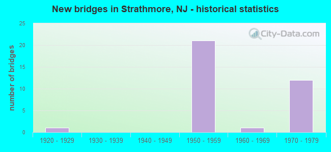
- New bridges - historical statistics
- 11920-1929
- 211950-1959
- 11960-1969
- 121970-1979
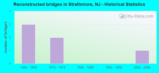
- Reconstructed bridges - Historical Statistics
- 31960-1969
- 21970-1979
- 01980-1989
- 01990-1999
- 12000-2009
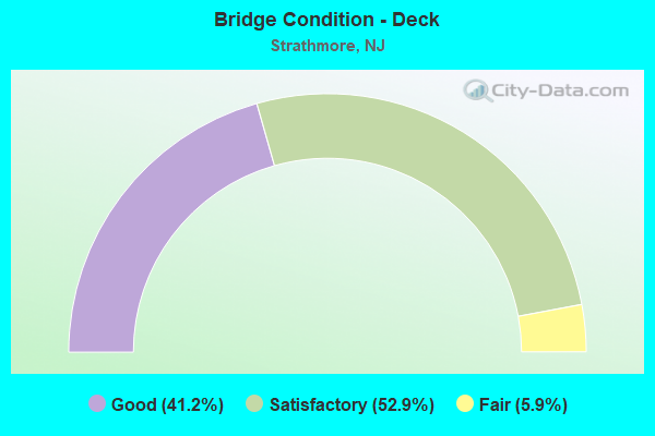
- Bridge Condition - Deck
- 41.2%Good
- 52.9%Satisfactory
- 5.9%Fair
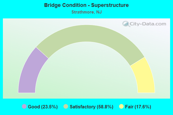
- Bridge Condition - Superstructure
- 23.5%Good
- 58.8%Satisfactory
- 17.6%Fair
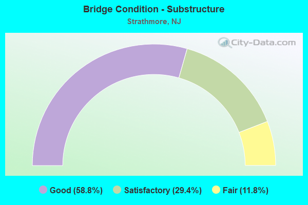
- Bridge Condition - Substructure
- 58.8%Good
- 29.4%Satisfactory
- 11.8%Fair
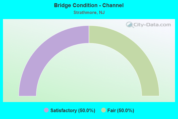
- Bridge Condition - Channel
- 50.0%Satisfactory
- 50.0%Fair
Find on map >> Show street view
Structure Number: 1300MA6, Location: 0.5 MI E OF INT NJ 34& 79 (Lat: 40.407850, Lng: -74.228619), Route carried "on" structure: County highway 45, Year Built: 1923, Status: Posted for load, Structure Length: 1.22m (4.00ft), Average Daily Traffic: 10,936 (year 2021), Truck Traffic: 3%, Average Future Daily Traffic: 13,344 (year 2041), Features Intersected: GRAVELLY BROOK
Minimum Vertical Clearance: 30+ m (98+ ft), Kilometerpoint: 0.692, Lanes on structure: 2, Owner: County Highway Agency, Approaching Roadway Width: 7.0m (23.0ft), Material/Design: Steel, Design/Construction: Girder and Floorbeam System, Number Of Spans In Main Unit: 1, Length of Maximum Span: 11.0m (36.1ft), Curb or Sidewalk Widths: Left: 0.2m (0.7ft), Right: 0.2m (0.7ft), Curb-To-Curb Width: 6.9m (22.6ft), Out-to-Out Width: 7.8m (25.6ft)
Condition: Deck: Fair, Superstructure: Fair, Substructure: Fair, Channel: Fair, Operating Rating: 24.5 metric tons, Method Used To Determine Operating Rating: Load Factor (LF), Inventory Rating: 14.5 metric tons, Method Used To Determine Inventory Rating: Load Factor (LF), Structural Evaluation: High priority of replacement, Deck Geometry: High priority of replacement, Waterway Adequacy: Meets minimum limits, Approach Roadway Alignment: Equal to present minimum criteria, Length Of Structure Improvement: 1.89m (6.20ft), Designated Inspection Frequency: Every 24 months, Critical Feature Inspection Frequency: Every 24 months, Underwater Inspection Frequency: Every 24 months, Inspection Date: May 2021, Critical Feature Inspection Date: May 2021, Underwater Inspection Date: May 2021, Bridge Improvement Cost: $976,000, Roadway Improvement Cost: $275,000, Total Project Cost: $1,766,000 ( Estimate for 2021), Deck Structure Type: Concrete Cast-file-Place, Wearing Surface/Protective System: Wearing Surface: Bituminous
Find on map >> Show street view
Structure Number: 1360153, Location: 0.73 MILE SOUTH OF NJ 35 (Lat: 40.418531, Lng: -74.212819), Route carried "on" structure: County highway 3, Year Built: 1965, Status: Open, Structure Length: 3.05m (10.01ft), Average Daily Traffic: 17,300 (year 2020), Truck Traffic: 4%, Average Future Daily Traffic: 20,760 (year 2040), Design Load: HS 20, Features Intersected: NORTH JERSEY COAST LINE
Minimum Vertical Clearance: 30+ m (98+ ft), Kilometerpoint: 20.117, Lanes on structure: 2, Owner: State Agenciy, Approaching Roadway Width: 11.0m (36.1ft), Material/Design: Prestressed concrete, Design/Construction: Box Beam or Girders - Multiple, Number Of Spans In Main Unit: 3, Length of Maximum Span: 12.2m (40.0ft), Curb or Sidewalk Widths: Left: 0.5m (1.6ft), Right: 1.9m (6.2ft), Curb-To-Curb Width: 11.0m (36.1ft), Out-to-Out Width: 14.1m (46.3ft)
Condition: Deck: Good, Superstructure: Good, Substructure: Fair, Operating Rating: 43.5 metric tons, Method Used To Determine Operating Rating: Load Factor (LF), Inventory Rating: 25.4 metric tons, Method Used To Determine Inventory Rating: Load Factor (LF), Structural Evaluation: Somewhat better than minimum adequacy, Deck Geometry: Meets minimum limits, Underclear: High priority of corrective action, Approach Roadway Alignment: Better than present minimum criteria, Length Of Structure Improvement: 3.05m (10.01ft), Designated Inspection Frequency: Every 24 months, Inspection Date: September 2020, Bridge Improvement Cost: $1,153,000, Roadway Improvement Cost: $173,000, Total Project Cost: $2,032,000 ( Estimate for 2020), Deck Structure Type: Concrete Cast-file-Place, Wearing Surface/Protective System: Wearing Surface: Bituminous, Membrane: Preformed Fabric
Find on map >> Show street view
Structure Number: 361158E, Location: 2.5 M SE OF GSP&NJ 36 JCT (Lat: 40.388728, Lng: -74.179239), Route carried "on" structure: Other road GSP, Year Built: 1975, Status: Open, Structure Length: 2.87m (9.42ft), Average Daily Traffic: 31,824 (year 2020), Truck Traffic: 1%, Average Future Daily Traffic: 38,820 (year 2040), Design Load: H 20, Features Intersected: TELEGRAPH HILL ROAD
Minimum Vertical Clearance: 30+ m (98+ ft), Kilometerpoint: 186.443, Lanes on structure: 2, Lanes under structure: 5, Base Highway Network: Yes, Toll: On toll road, Owner: State Toll Authority, Approaching Roadway Width: 14.0m (45.9ft), Skew: 2 degrees, Material/Design: Prestressed concrete, Design/Construction: Box Beam or Girders - Multiple, Number Of Spans In Main Unit: 1, Length of Maximum Span: 28.0m (91.9ft), Curb-To-Curb Width: 11.4m (37.4ft), Out-to-Out Width: 12.3m (40.4ft)
Condition: Deck: Good, Superstructure: Satisfactory, Substructure: Satisfactory, Operating Rating: 45.4 metric tons, Method Used To Determine Operating Rating: Load and Resistance Factor Rating (LRFR) rating reported by rating factor(RF) method using HL-93 loadings, Inventory Rating: 35.0 metric tons, Method Used To Determine Inventory Rating: Load and Resistance Factor Rating (LRFR) rating reported by rating factor(RF) method using HL-93 loadings, Structural Evaluation: Equal to present minimum criteria, Deck Geometry: Somewhat better than minimum adequacy, Underclear: High priority of corrective action, Approach Roadway Alignment: Better than present minimum criteria, Length Of Structure Improvement: 2.90m (9.51ft), Designated Inspection Frequency: Every 24 months, Inspection Date: May 2020, Bridge Improvement Cost: $1,116,000, Roadway Improvement Cost: $300,000, Total Project Cost: $1,860,000 ( Estimate for 2016), Deck Structure Type: Concrete Cast-file-Place, Wearing Surface/Protective System: Wearing Surface: Bituminous, Membrane: Preformed Fabric
Find on map >> Show street view
Structure Number: 361158U, Location: 2.5 MI SE OF GSP&RT36 JCT (Lat: 40.388569, Lng: -74.179433), Route carried "on" structure: Other road GSP, Year Built: 1954, Status: Open, Structure Length: 3.47m (11.38ft), Average Daily Traffic: 31,830 (year 2020), Truck Traffic: 1%, Average Future Daily Traffic: 38,820 (year 2040), Design Load: H 20, Features Intersected: TELEGRAPH HILL PARK ROAD
Minimum Vertical Clearance: 30+ m (98+ ft), Kilometerpoint: 186.443, Lanes on structure: 3, Lanes under structure: 5, Base Highway Network: Yes, Toll: On toll road, Owner: State Toll Authority, Approaching Roadway Width: 14.0m (45.9ft), Skew: 2 degrees, Material/Design: Steel, Design/Construction: Stringer/Multi-beam, Number Of Spans In Main Unit: 3, Length of Maximum Span: 13.1m (43.0ft), Curb-To-Curb Width: 14.3m (46.9ft), Out-to-Out Width: 15.2m (49.9ft)
Condition: Deck: Satisfactory, Superstructure: Satisfactory, Substructure: Good, Operating Rating: 57.7 metric tons, Method Used To Determine Operating Rating: Load and Resistance Factor Rating (LRFR) rating reported by rating factor(RF) method using HL-93 loadings, Inventory Rating: 44.4 metric tons, Method Used To Determine Inventory Rating: Load and Resistance Factor Rating (LRFR) rating reported by rating factor(RF) method using HL-93 loadings, Structural Evaluation: Equal to present minimum criteria, Deck Geometry: Meets minimum limits, Underclear: High priority of corrective action, Approach Roadway Alignment: Better than present minimum criteria, Length Of Structure Improvement: 3.66m (12.01ft), Designated Inspection Frequency: Every 24 months, Inspection Date: May 2020, Bridge Improvement Cost: $1,675,000, Roadway Improvement Cost: $300,000, Total Project Cost: $3,793,000 ( Estimate for 2018), Deck Structure Type: Concrete Cast-file-Place, Wearing Surface/Protective System: Wearing Surface: Bituminous, Membrane: Preformed Fabric
Find on map >> Show street view
Structure Number: 361159I, Location: 2.5 MI SE OF GSP&RT36 JCT (Lat: 40.389225, Lng: -74.178714), Route carried "on" structure: Other road GSP, Year Built: 1972, Status: Open, Structure Length: 2.74m (8.99ft), Average Daily Traffic: 31,824 (year 2020), Truck Traffic: 1%, Average Future Daily Traffic: 38,820 (year 2040), Design Load: H 20, Features Intersected: TELEGRAPH HILL ROAD
Minimum Vertical Clearance: 30+ m (98+ ft), Kilometerpoint: 186.443, Lanes on structure: 2, Lanes under structure: 5, Base Highway Network: Yes, Toll: On toll road, Owner: State Toll Authority, Approaching Roadway Width: 11.6m (38.1ft), Skew: 1 degrees, Material/Design: Prestressed concrete, Design/Construction: Box Beam or Girders - Multiple, Number Of Spans In Main Unit: 1, Length of Maximum Span: 26.8m (87.9ft), Curb-To-Curb Width: 11.5m (37.7ft), Out-to-Out Width: 12.4m (40.7ft)
Condition: Deck: Good, Superstructure: Satisfactory, Substructure: Satisfactory, Operating Rating: 40.8 metric tons, Method Used To Determine Operating Rating: Load and Resistance Factor Rating (LRFR) rating reported by rating factor(RF) method using HL-93 loadings, Inventory Rating: 31.4 metric tons, Method Used To Determine Inventory Rating: Load and Resistance Factor Rating (LRFR) rating reported by rating factor(RF) method using HL-93 loadings, Structural Evaluation: Equal to present minimum criteria, Deck Geometry: Somewhat better than minimum adequacy, Underclear: High priority of corrective action, Approach Roadway Alignment: Equal to present desirable criteria, Length Of Structure Improvement: 2.90m (9.51ft), Designated Inspection Frequency: Every 24 months, Inspection Date: May 2020, Bridge Improvement Cost: $300,000, Roadway Improvement Cost: $50,000, Total Project Cost: $750,000 ( Estimate for 2016), Deck Structure Type: Concrete Cast-file-Place, Wearing Surface/Protective System: Wearing Surface: Bituminous
Find on map >> Show street view
Structure Number: 361159O, Location: 2.5MLS.SE OF GSP&RT36 JCT (Lat: 40.389386, Lng: -74.178500), Route carried "on" structure: Other road GSP, Year Built: 1954, Status: Open, Structure Length: 3.29m (10.79ft), Average Daily Traffic: 31,824 (year 2019), Truck Traffic: 1%, Average Future Daily Traffic: 38,820 (year 2039), Design Load: H 20, Features Intersected: TELEGRAPH HILL ROAD
Minimum Vertical Clearance: 30+ m (98+ ft), Kilometerpoint: 186.443, Lanes on structure: 3, Lanes under structure: 5, Base Highway Network: Yes, Toll: On toll road, Owner: State Toll Authority, Approaching Roadway Width: 14.3m (46.9ft), Skew: 1 degrees, Material/Design: Steel, Design/Construction: Stringer/Multi-beam, Number Of Spans In Main Unit: 3, Length of Maximum Span: 12.2m (40.0ft), Curb-To-Curb Width: 14.4m (47.2ft), Out-to-Out Width: 15.3m (50.2ft)
Condition: Deck: Satisfactory, Superstructure: Fair, Substructure: Satisfactory, Operating Rating: 36.6 metric tons, Method Used To Determine Operating Rating: Load and Resistance Factor Rating (LRFR) rating reported by rating factor(RF) method using HL-93 loadings, Inventory Rating: 28.2 metric tons, Method Used To Determine Inventory Rating: Load and Resistance Factor Rating (LRFR) rating reported by rating factor(RF) method using HL-93 loadings, Structural Evaluation: Somewhat better than minimum adequacy, Deck Geometry: Meets minimum limits, Underclear: High priority of corrective action, Approach Roadway Alignment: Equal to present desirable criteria, Length Of Structure Improvement: 3.66m (12.01ft), Designated Inspection Frequency: Every 24 months, Inspection Date: May 2020, Bridge Improvement Cost: $1,675,000, Roadway Improvement Cost: $300,000, Total Project Cost: $2,793,000 ( Estimate for 2016), Deck Structure Type: Concrete Cast-file-Place, Wearing Surface/Protective System: Wearing Surface: Bituminous
Find on map >> Show street view
Structure Number: 361167S, Location: 1.5 MI SE OF GSP&RT36 JCT (Lat: 40.399489, Lng: -74.189008), Route carried "on" structure: County highway 4, Year Built: 1954, Year Reconstructed: 1975, Status: Open, Structure Length: 8.56m (28.08ft), Average Daily Traffic: 7,054 (year 2020), Truck Traffic: 4%, Average Future Daily Traffic: 8,605 (year 2040), Design Load: HS 20, Features Intersected: GSP SBI & SBO
Minimum Vertical Clearance: 30+ m (98+ ft), Kilometerpoint: 10.300, Lanes on structure: 2, Lanes under structure: 6, Owner: State Toll Authority, Approaching Roadway Width: 9.1m (29.9ft), Skew: 4 degrees, Material/Design: Steel, Design/Construction: Stringer/Multi-beam, Number Of Spans In Main Unit: 4, Length of Maximum Span: 31.4m (103.0ft), Curb or Sidewalk Widths: Left: 1.7m (5.6ft), Right: 0.9m (3.0ft), Curb-To-Curb Width: 8.9m (29.2ft), Out-to-Out Width: 12.3m (40.4ft)
Condition: Deck: Satisfactory, Superstructure: Satisfactory, Substructure: Good, Operating Rating: 67.7 metric tons, Method Used To Determine Operating Rating: Load and Resistance Factor Rating (LRFR) rating reported by rating factor(RF) method using HL-93 loadings, Inventory Rating: 52.2 metric tons, Method Used To Determine Inventory Rating: Load and Resistance Factor Rating (LRFR) rating reported by rating factor(RF) method using HL-93 loadings, Structural Evaluation: Equal to present minimum criteria, Deck Geometry: Meets minimum limits, Underclear: High priority of corrective action, Approach Roadway Alignment: Equal to present desirable criteria, Length Of Structure Improvement: 8.56m (28.08ft), Designated Inspection Frequency: Every 24 months, Inspection Date: July 2020, Bridge Improvement Cost: $3,372,000, Roadway Improvement Cost: $500,000, Total Project Cost: $5,620,000 ( Estimate for 2018), Deck Structure Type: Concrete Cast-file-Place, Wearing Surface/Protective System: Wearing Surface: Bituminous, Membrane: Preformed Fabric
Find on map >> Show street view
Structure Number: 361169N, Location: 1.5 MI SE OF GSP&RT36 JCT (Lat: 40.401150, Lng: -74.189169), Route carried "on" structure: County highway 4, Year Built: 1954, Status: Open, Structure Length: 9.81m (32.19ft), Average Daily Traffic: 7,054 (year 2020), Truck Traffic: 3%, Average Future Daily Traffic: 8,605 (year 2040), Design Load: HS 20, Features Intersected: GSP NBI & NBO
Minimum Vertical Clearance: 30+ m (98+ ft), Kilometerpoint: 10.493, Lanes on structure: 2, Lanes under structure: 5, Owner: State Toll Authority, Approaching Roadway Width: 9.1m (29.9ft), Skew: 4 degrees, Material/Design: Steel, Design/Construction: Stringer/Multi-beam, Number Of Spans In Main Unit: 5, Length of Maximum Span: 21.9m (71.9ft), Curb or Sidewalk Widths: Left: 1.7m (5.6ft), Right: 0.9m (3.0ft), Curb-To-Curb Width: 9.1m (29.9ft), Out-to-Out Width: 12.6m (41.3ft)
Condition: Deck: Satisfactory, Superstructure: Satisfactory, Substructure: Good, Operating Rating: 72.3 metric tons, Method Used To Determine Operating Rating: Load and Resistance Factor Rating (LRFR) rating reported by rating factor(RF) method using HL-93 loadings, Inventory Rating: 55.7 metric tons, Method Used To Determine Inventory Rating: Load and Resistance Factor Rating (LRFR) rating reported by rating factor(RF) method using HL-93 loadings, Structural Evaluation: Equal to present minimum criteria, Deck Geometry: Meets minimum limits, Underclear: High priority of corrective action, Approach Roadway Alignment: Better than present minimum criteria, Length Of Structure Improvement: 10.36m (33.99ft), Designated Inspection Frequency: Every 24 months, Inspection Date: July 2020, Bridge Improvement Cost: $3,960,000, Roadway Improvement Cost: $1,000,000, Total Project Cost: $16,600,000 ( Estimate for 2016), Deck Structure Type: Concrete Cast-file-Place, Wearing Surface/Protective System: Wearing Surface: Bituminous, Membrane: Preformed Fabric
Find on map >> Show street view
Structure Number: 361174U, Location: 1 MI SE OF GSP & RT36 JCT (Lat: 40.405617, Lng: -74.197692), Route carried "on" structure: Ramp Other road GSP, Year Built: 1975, Status: Open, Structure Length: 15.51m (50.89ft), Average Daily Traffic: 1,367 (year 2020), Truck Traffic: 1%, Average Future Daily Traffic: 1,668 (year 2040), Design Load: H 20, Features Intersected: GSP SBO, Facility Carried by Structure: SBI EXIT RAMP FLYO
Minimum Vertical Clearance: 30+ m (98+ ft), Kilometerpoint: 188.937, Lanes on structure: 1, Lanes under structure: 3, Toll: On toll road, Owner: State Toll Authority, Approaching Roadway Width: 5.8m (19.0ft), Skew: 9 degrees, Material/Design: Steel continuous, Design/Construction: Stringer/Multi-beam, Number Of Spans In Main Unit: 4, Length of Maximum Span: 50.6m (166.0ft), Curb-To-Curb Width: 5.8m (19.0ft), Out-to-Out Width: 6.7m (22.0ft)
Condition: Deck: Satisfactory, Superstructure: Fair, Substructure: Good, Operating Rating: 64.5 metric tons, Method Used To Determine Operating Rating: Load and Resistance Factor Rating (LRFR) rating reported by rating factor(RF) method using HL-93 loadings, Inventory Rating: 49.9 metric tons, Method Used To Determine Inventory Rating: Load and Resistance Factor Rating (LRFR) rating reported by rating factor(RF) method using HL-93 loadings, Structural Evaluation: Somewhat better than minimum adequacy, Deck Geometry: Meets minimum limits, Underclear: High priority of corrective action, Approach Roadway Alignment: Equal to present minimum criteria, Length Of Structure Improvement: 15.51m (50.89ft), Designated Inspection Frequency: Every 24 months, Critical Feature Inspection Frequency: Every 24 months, Inspection Date: July 2020, Critical Feature Inspection Date: July 2020, Bridge Improvement Cost: $1,777,000, Roadway Improvement Cost: $530,000, Total Project Cost: $2,962,000 ( Estimate for 2016), Deck Structure Type: Concrete Cast-file-Place, Wearing Surface/Protective System: Wearing Surface: Bituminous, Membrane: Preformed Fabric
Find on map >> Show street view
Structure Number: 361176N, Location: 0.74 mi. N of GSP/CR4 Jct (Lat: 40.408881, Lng: -74.198606), Route carried "on" structure: City street , Year Built: 1954, Year Reconstructed: 1975, Status: Open, Structure Length: 5.88m (19.29ft), Average Daily Traffic: 11,073 (year 2020), Truck Traffic: 3%, Average Future Daily Traffic: 13,510 (year 2040), Design Load: HS 20, Features Intersected: GSP NBI & NBO, Facility Carried by Structure: BETHANY ROAD
Minimum Vertical Clearance: 30+ m (98+ ft), Kilometerpoint: 1.625, Lanes on structure: 2, Lanes under structure: 5, Owner: State Toll Authority, Approaching Roadway Width: 7.9m (25.9ft), Skew: 2 degrees, Material/Design: Steel, Design/Construction: Stringer/Multi-beam, Number Of Spans In Main Unit: 4, Length of Maximum Span: 18.6m (61.0ft), Curb or Sidewalk Widths: Left: 1.5m (4.9ft), Right: 0.0m, Curb-To-Curb Width: 8.0m (26.2ft), Out-to-Out Width: 10.4m (34.1ft)
Condition: Deck: Good, Superstructure: Good, Substructure: Satisfactory, Operating Rating: 59.9 metric tons, Method Used To Determine Operating Rating: Load and Resistance Factor Rating (LRFR) rating reported by rating factor(RF) method using HL-93 loadings, Inventory Rating: 46.0 metric tons, Method Used To Determine Inventory Rating: Load and Resistance Factor Rating (LRFR) rating reported by rating factor(RF) method using HL-93 loadings, Structural Evaluation: Equal to present minimum criteria, Deck Geometry: High priority of replacement, Underclear: High priority of corrective action, Approach Roadway Alignment: Equal to present desirable criteria, Length Of Structure Improvement: 6.40m (21.00ft), Designated Inspection Frequency: Every 24 months, Inspection Date: September 2020, Bridge Improvement Cost: $1,968,000, Roadway Improvement Cost: $350,000, Total Project Cost: $3,347,000 ( Estimate for 2016), Deck Structure Type: Concrete Cast-file-Place, Wearing Surface/Protective System: Wearing Surface: Bituminous, Membrane: Preformed Fabric, Deck Protection: Epoxy Coated Reinforcing
Find on map >> Show street view
Structure Number: 361176S, Location: 0.74 mi. N of GSP/CR4 Jct (Lat: 40.408181, Lng: -74.199708), Route carried "on" structure: City street , Year Built: 1954, Status: Open, Structure Length: 7.25m (23.79ft), Average Daily Traffic: 10,269 (year 2020), Truck Traffic: 3%, Average Future Daily Traffic: 12,530 (year 2040), Design Load: HS 20, Features Intersected: GSP SBI & SBO, Facility Carried by Structure: BETHANY ROAD
Minimum Vertical Clearance: 30+ m (98+ ft), Kilometerpoint: 1.529, Lanes on structure: 2, Lanes under structure: 6, Owner: State Toll Authority, Approaching Roadway Width: 7.9m (25.9ft), Skew: 1 degrees, Material/Design: Steel, Design/Construction: Stringer/Multi-beam, Number Of Spans In Main Unit: 5, Length of Maximum Span: 16.8m (55.1ft), Curb or Sidewalk Widths: Left: 1.5m (4.9ft), Right: 0.0m, Curb-To-Curb Width: 8.0m (26.2ft), Out-to-Out Width: 10.4m (34.1ft)
Condition: Deck: Satisfactory, Superstructure: Satisfactory, Substructure: Good, Operating Rating: 58.3 metric tons, Method Used To Determine Operating Rating: Load and Resistance Factor Rating (LRFR) rating reported by rating factor(RF) method using HL-93 loadings, Inventory Rating: 44.7 metric tons, Method Used To Determine Inventory Rating: Load and Resistance Factor Rating (LRFR) rating reported by rating factor(RF) method using HL-93 loadings, Structural Evaluation: Equal to present minimum criteria, Deck Geometry: High priority of corrective action, Underclear: High priority of corrective action, Approach Roadway Alignment: Equal to present desirable criteria, Length Of Structure Improvement: 7.62m (25.00ft), Designated Inspection Frequency: Every 24 months, Inspection Date: September 2020, Bridge Improvement Cost: $3,927,000, Roadway Improvement Cost: $1,000,000, Total Project Cost: $6,676,000 ( Estimate for 2018), Deck Structure Type: Concrete Cast-file-Place, Wearing Surface/Protective System: Wearing Surface: Bituminous
Find on map >> Show street view
Structure Number: 361183E, Location: 0.25 MI SE OF GSP&RT36 JC (Lat: 40.417381, Lng: -74.205411), Route carried "on" structure: Other road GSP, Year Built: 1975, Status: Open, Structure Length: 7.56m (24.80ft), Average Daily Traffic: 30,755 (year 2020), Truck Traffic: 1%, Average Future Daily Traffic: 37,526 (year 2040), Design Load: H 20, Features Intersected: NJ TRANSIT RR, Facility Carried by Structure: PARKWAY SBI
Minimum Vertical Clearance: 30+ m (98+ ft), Kilometerpoint: 190.385, Lanes on structure: 3, Base Highway Network: Yes, Toll: On toll road, Owner: State Toll Authority, Approaching Roadway Width: 12.5m (41.0ft), Skew: 5 degrees, Material/Design: Prestressed concrete, Design/Construction: Stringer/Multi-beam, Number Of Spans In Main Unit: 3, Length of Maximum Span: 25.6m (84.0ft), Curb-To-Curb Width: 12.5m (41.0ft), Out-to-Out Width: 13.4m (44.0ft)
Condition: Deck: Good, Superstructure: Satisfactory, Substructure: Satisfactory, Operating Rating: 39.5 metric tons, Method Used To Determine Operating Rating: Load and Resistance Factor Rating (LRFR) rating reported by rating factor(RF) method using HL-93 loadings, Inventory Rating: 16.2 metric tons, Method Used To Determine Inventory Rating: Load and Resistance Factor Rating (LRFR) rating reported by rating factor(RF) method using HL-93 loadings, Structural Evaluation: Meets minimum limits, Deck Geometry: Meets minimum limits, Underclear: Somewhat better than minimum adequacy, Approach Roadway Alignment: Better than present minimum criteria, Designated Inspection Frequency: Every 24 months, Inspection Date: July 2020, Deck Structure Type: Concrete Cast-file-Place, Wearing Surface/Protective System: Wearing Surface: Bituminous
Find on map >> Show street view
Structure Number: 361185B, Location: GSP Interchange 117 (Lat: 40.419353, Lng: -74.207825), Route carried "on" structure: Other road GSP, Year Built: 1971, Year Reconstructed: 2013, Status: Open, Structure Length: 1.07m (3.51ft), Average Daily Traffic: 83,232 (year 2020), Truck Traffic: 1%, Average Future Daily Traffic: 99,700 (year 2040), Design Load: HS 20, Features Intersected: Luppatcong Creek, Facility Carried by Structure: NBI & NBO & Ramps
Minimum Vertical Clearance: 30+ m (98+ ft), Kilometerpoint: 190.788, Lanes on structure: 6, Base Highway Network: Yes, Toll: On toll road, Owner: State Toll Authority, Approaching Roadway Width: 39.3m (128.9ft), Skew: 1 degrees, Design/Construction: Culvert, Number Of Spans In Main Unit: 2, Length of Maximum Span: 4.3m (14.1ft)
Condition: Channel: Satisfactory, Culverts: Good, Structural Evaluation: Better than present minimum criteria, Waterway Adequacy: Superior to present desirable criteria, Approach Roadway Alignment: Equal to present desirable criteria, Designated Inspection Frequency: Every 24 months, Inspection Date: July 2020
Find on map >> Show street view
Structure Number: 361185E, Location: AT GSP & RT 36 JUNCTION (Lat: 40.418903, Lng: -74.208425), Route carried "on" structure: Other road GSP, Year Built: 1972, Status: Open, Structure Length: 4.11m (13.48ft), Average Daily Traffic: 35,325 (year 2020), Truck Traffic: 1%, Average Future Daily Traffic: 43,096 (year 2040), Design Load: H 20, Features Intersected: INT.117 SB EXIT RAMP A, Facility Carried by Structure: PARKWAY SBI
Minimum Vertical Clearance: 30+ m (98+ ft), Kilometerpoint: 190.707, Lanes on structure: 3, Lanes under structure: 2, Base Highway Network: Yes, Toll: On toll road, Owner: State Toll Authority, Approaching Roadway Width: 12.5m (41.0ft), Skew: 3 degrees, Material/Design: Prestressed concrete, Design/Construction: Box Beam or Girders - Single/Spread, Number Of Spans In Main Unit: 3, Length of Maximum Span: 20.4m (66.9ft), Curb-To-Curb Width: 12.5m (41.0ft), Out-to-Out Width: 13.4m (44.0ft)
Condition: Deck: Satisfactory, Superstructure: Good, Substructure: Good, Operating Rating: 29.8 metric tons, Method Used To Determine Operating Rating: Load and Resistance Factor Rating (LRFR) rating reported by rating factor(RF) method using HL-93 loadings, Inventory Rating: 23.0 metric tons, Method Used To Determine Inventory Rating: Load and Resistance Factor Rating (LRFR) rating reported by rating factor(RF) method using HL-93 loadings, Structural Evaluation: Somewhat better than minimum adequacy, Deck Geometry: High priority of replacement, Underclear: High priority of corrective action, Approach Roadway Alignment: Equal to present desirable criteria, Length Of Structure Improvement: 4.11m (13.48ft), Designated Inspection Frequency: Every 24 months, Inspection Date: July 2020, Bridge Improvement Cost: $2,528,000, Roadway Improvement Cost: $379,000, Total Project Cost: $3,287,000 ( Estimate for 2016), Deck Structure Type: Concrete Cast-file-Place, Wearing Surface/Protective System: Wearing Surface: Bituminous
Find on map >> Show street view
Structure Number: 361185I, Location: AT GSP & RT 36 JUNCTION (Lat: 40.419042, Lng: -74.207969), Route carried "on" structure: Other road GSP, Year Built: 1974, Status: Open, Structure Length: 3.96m (12.99ft), Average Daily Traffic: 40,841 (year 2020), Truck Traffic: 1%, Average Future Daily Traffic: 49,833 (year 2040), Design Load: H 20, Features Intersected: INT.117 SB EXIT RAMP A, Facility Carried by Structure: PARKWAY NBI
Minimum Vertical Clearance: 30+ m (98+ ft), Kilometerpoint: 190.707, Lanes on structure: 2, Lanes under structure: 2, Base Highway Network: Yes, Toll: On toll road, Owner: State Toll Authority, Approaching Roadway Width: 12.5m (41.0ft), Skew: 3 degrees, Material/Design: Prestressed concrete, Design/Construction: Box Beam or Girders - Single/Spread, Number Of Spans In Main Unit: 3, Length of Maximum Span: 20.7m (67.9ft), Curb-To-Curb Width: 12.5m (41.0ft), Out-to-Out Width: 13.4m (44.0ft)
Condition: Deck: Good, Superstructure: Good, Substructure: Good, Operating Rating: 30.8 metric tons, Method Used To Determine Operating Rating: Load and Resistance Factor Rating (LRFR) rating reported by rating factor(RF) method using HL-93 loadings, Inventory Rating: 24.0 metric tons, Method Used To Determine Inventory Rating: Load and Resistance Factor Rating (LRFR) rating reported by rating factor(RF) method using HL-93 loadings, Structural Evaluation: Somewhat better than minimum adequacy, Deck Geometry: Better than present minimum criteria, Underclear: Somewhat better than minimum adequacy, Approach Roadway Alignment: Equal to present desirable criteria, Designated Inspection Frequency: Every 24 months, Inspection Date: August 2020, Deck Structure Type: Concrete Cast-file-Place, Wearing Surface/Protective System: Wearing Surface: Bituminous
Find on map >> Show street view
Structure Number: 361185U, Location: AT GSP & RT 36 JUNCTION (Lat: 40.418714, Lng: -74.210025), Route carried "on" structure: Other road GSP, Year Built: 1953, Year Reconstructed: 1971, Status: Open, Structure Length: 6.19m (20.31ft), Average Daily Traffic: 55,162 (year 2020), Truck Traffic: 1%, Average Future Daily Traffic: 67,298 (year 2040), Design Load: H 20, Features Intersected: INT.117 SB EXIT RAMP A, Facility Carried by Structure: PARKWAY SBO
Minimum Vertical Clearance: 30+ m (98+ ft), Kilometerpoint: 190.707, Lanes on structure: 3, Lanes under structure: 1, Base Highway Network: Yes, Toll: On toll road, Owner: State Toll Authority, Approaching Roadway Width: 16.5m (54.1ft), Skew: 5 degrees, Material/Design: Steel, Design/Construction: Stringer/Multi-beam, Number Of Spans In Main Unit: 3, Length of Maximum Span: 29.0m (95.1ft), Curb-To-Curb Width: 16.6m (54.5ft), Out-to-Out Width: 17.5m (57.4ft)
Condition: Deck: Good, Superstructure: Satisfactory, Substructure: Good, Operating Rating: 54.8 metric tons, Method Used To Determine Operating Rating: Load and Resistance Factor Rating (LRFR) rating reported by rating factor(RF) method using HL-93 loadings, Inventory Rating: 42.1 metric tons, Method Used To Determine Inventory Rating: Load and Resistance Factor Rating (LRFR) rating reported by rating factor(RF) method using HL-93 loadings, Structural Evaluation: Equal to present minimum criteria, Deck Geometry: Equal to present minimum criteria, Underclear: High priority of corrective action, Approach Roadway Alignment: Superior to present desirable criteria, Length Of Structure Improvement: 6.19m (20.31ft), Designated Inspection Frequency: Every 24 months, Inspection Date: July 2020, Bridge Improvement Cost: $3,708,000, Roadway Improvement Cost: $556,000, Total Project Cost: $4,820,000 ( Estimate for 2016), Deck Structure Type: Concrete Cast-file-Place, Wearing Surface/Protective System: Wearing Surface: Bituminous
Find on map >> Show street view
Structure Number: 361186U, Location: 0.25 MI NW OF GSP&RT36 JC (Lat: 40.419989, Lng: -74.212428), Route carried "on" structure: County highway 3, Year Built: 1953, Year Reconstructed: 1971, Status: Open, Structure Length: 7.74m (25.39ft), Average Daily Traffic: 12,353 (year 2020), Truck Traffic: 4%, Average Future Daily Traffic: 15,068 (year 2040), Design Load: H 20, Features Intersected: SBO & SB RAMPS A1 & E
Minimum Vertical Clearance: 30+ m (98+ ft), Kilometerpoint: 20.294, Lanes on structure: 2, Lanes under structure: 5, Owner: State Toll Authority, Approaching Roadway Width: 11.0m (36.1ft), Skew: 3 degrees, Material/Design: Steel, Design/Construction: Stringer/Multi-beam, Number Of Spans In Main Unit: 5, Length of Maximum Span: 18.9m (62.0ft), Curb or Sidewalk Widths: Left: 0.8m (2.6ft), Right: 0.8m (2.6ft), Curb-To-Curb Width: 11.0m (36.1ft), Out-to-Out Width: 13.5m (44.3ft)
Condition: Deck: Satisfactory, Superstructure: Satisfactory, Substructure: Good, Operating Rating: 62.5 metric tons, Method Used To Determine Operating Rating: Load and Resistance Factor Rating (LRFR) rating reported by rating factor(RF) method using HL-93 loadings, Inventory Rating: 48.3 metric tons, Method Used To Determine Inventory Rating: Load and Resistance Factor Rating (LRFR) rating reported by rating factor(RF) method using HL-93 loadings, Structural Evaluation: Equal to present minimum criteria, Deck Geometry: Meets minimum limits, Underclear: High priority of corrective action, Approach Roadway Alignment: Equal to present minimum criteria, Length Of Structure Improvement: 7.74m (25.39ft), Designated Inspection Frequency: Every 24 months, Inspection Date: September 2020, Bridge Improvement Cost: $500,000, Roadway Improvement Cost: $250,000, Total Project Cost: $750,000 ( Estimate for 2018), Deck Structure Type: Concrete Cast-file-Place, Wearing Surface/Protective System: Wearing Surface: Bituminous, Membrane: Preformed Fabric
Find on map >> Show street view
Structure Number: 361191T, Location: 0.5 MI NW OF GSP &RT36 JC (Lat: 40.423228, Lng: -74.217167), Route carried "on" structure: County highway 516, Year Built: 1953, Year Reconstructed: 1972, Status: Open, Structure Length: 10.58m (34.71ft), Average Daily Traffic: 13,054 (year 2020), Truck Traffic: 4%, Average Future Daily Traffic: 15,922 (year 2040), Design Load: H 20, Features Intersected: GARDEN STATE PARKWAY
Minimum Vertical Clearance: 30+ m (98+ ft), Kilometerpoint: 14.082, Lanes on structure: 2, Lanes under structure: 12, Owner: State Toll Authority, Approaching Roadway Width: 12.2m (40.0ft), Skew: 2 degrees, Material/Design: Steel, Design/Construction: Stringer/Multi-beam, Number Of Spans In Main Unit: 6, Length of Maximum Span: 23.2m (76.1ft), Curb or Sidewalk Widths: Left: 1.5m (4.9ft), Right: 1.5m (4.9ft), Curb-To-Curb Width: 12.2m (40.0ft), Out-to-Out Width: 15.9m (52.2ft)
Condition: Deck: Satisfactory, Superstructure: Satisfactory, Substructure: Good, Operating Rating: 57.3 metric tons, Method Used To Determine Operating Rating: Load and Resistance Factor Rating (LRFR) rating reported by rating factor(RF) method using HL-93 loadings, Inventory Rating: 44.1 metric tons, Method Used To Determine Inventory Rating: Load and Resistance Factor Rating (LRFR) rating reported by rating factor(RF) method using HL-93 loadings, Structural Evaluation: Equal to present minimum criteria, Deck Geometry: Somewhat better than minimum adequacy, Underclear: High priority of corrective action, Approach Roadway Alignment: Somewhat better than minimum adequacy, Length Of Structure Improvement: 10.58m (34.71ft), Designated Inspection Frequency: Every 24 months, Inspection Date: July 2020, Bridge Improvement Cost: $200,000, Roadway Improvement Cost: $400,000, Total Project Cost: $600,000 ( Estimate for 2016), Deck Structure Type: Concrete Cast-file-Place, Wearing Surface/Protective System: Wearing Surface: Bituminous, Membrane: Other
Find on map >> Show street view
Structure Number: 361158E, Location: 2.5 M SE OF GSP&NJ 36 JCT (Lat: 40.388728, Lng: -74.179239), Route carried "under" structure: City street , Year Built: 1975, Structure Length: 0. m, Average Daily Traffic: 3,599 (year 2020), Truck Traffic: 1%, Features Intersected: TELEGRAPH HILL ROAD, Facility Carried by Structure: GSP SBI
Minimum Vertical Clearance: 5.00m (16.40ft), Kilometerpoint: 0.000, Lanes on structure: 2, Lanes under structure: 5, Material/Design: Prestressed concrete, Design/Construction: Box Beam or Girders - Multiple, Length of Maximum Span: 28.0m (91.9ft)
Find on map >> Show street view
Structure Number: 361158U, Location: 2.5 MI SE OF GSP&RT36 JCT (Lat: 40.388569, Lng: -74.179433), Route carried "under" structure: City street , Year Built: 1954, Structure Length: 0. m, Average Daily Traffic: 3,707 (year 2020), Truck Traffic: 1%, Features Intersected: TELEGRAPH HILL PARK ROAD, Facility Carried by Structure: GSP SBO
Minimum Vertical Clearance: 4.67m (15.32ft), Kilometerpoint: 0.000, Lanes on structure: 3, Lanes under structure: 5, Material/Design: Steel, Design/Construction: Stringer/Multi-beam, Length of Maximum Span: 13.1m (43.0ft)
Find on map >> Show street view
Structure Number: 361159I, Location: 2.5 MI SE OF GSP&RT36 JCT (Lat: 40.389225, Lng: -74.178714), Route carried "under" structure: City street , Year Built: 1972, Structure Length: 0. m, Average Daily Traffic: 2,915 (year 2020), Truck Traffic: 1%, Features Intersected: TELEGRAPH HILL ROAD, Facility Carried by Structure: GSP NBI
Minimum Vertical Clearance: 4.70m (15.42ft), Kilometerpoint: 0.000, Lanes on structure: 2, Lanes under structure: 5, Material/Design: Prestressed concrete, Design/Construction: Box Beam or Girders - Multiple, Length of Maximum Span: 26.8m (87.9ft)
Find on map >> Show street view
Structure Number: 361159O, Location: 2.5MLS.SE OF GSP&RT36 JCT (Lat: 40.389386, Lng: -74.178500), Route carried "under" structure: City street , Year Built: 1954, Structure Length: 0. m, Average Daily Traffic: 2,849 (year 2018), Truck Traffic: 1%, Features Intersected: TELEGRAPH HILL ROAD, Facility Carried by Structure: GSP NBO
Minimum Vertical Clearance: 4.57m (14.99ft), Kilometerpoint: 0.000, Lanes on structure: 3, Lanes under structure: 5, Material/Design: Steel, Design/Construction: Stringer/Multi-beam, Length of Maximum Span: 12.2m (40.0ft)
Find on map >> Show street view
Structure Number: 361167S, Location: 1.5 MI SE OF GSP&RT36 JCT (Lat: 40.399489, Lng: -74.189008), Route carried "under" structure: Other road GSP, Year Built: 1954, Structure Length: 0. m, Average Daily Traffic: 76,680 (year 2020), Truck Traffic: 5%, Features Intersected: GSP SBI & SBO, Facility Carried by Structure: HOLMDEL RD (CR 4)
Minimum Vertical Clearance: 4.44m (14.57ft), Kilometerpoint: 188.068, Lanes on structure: 2, Lanes under structure: 6, Toll: On toll road, Material/Design: Steel, Design/Construction: Stringer/Multi-beam, Length of Maximum Span: 31.4m (103.0ft)
Find on map >> Show street view
Structure Number: 361169N, Location: 1.5 MI SE OF GSP&RT36 JCT (Lat: 40.401150, Lng: -74.189169), Route carried "under" structure: Other road GSP, Year Built: 1954, Structure Length: 0. m, Average Daily Traffic: 85,980 (year 2020), Truck Traffic: 5%, Features Intersected: GSP NBI & NBO, Facility Carried by Structure: HOLMDEL RD (CR 4)
Minimum Vertical Clearance: 4.55m (14.93ft), Kilometerpoint: 188.068, Lanes on structure: 2, Lanes under structure: 5, Toll: On toll road, Material/Design: Steel, Design/Construction: Stringer/Multi-beam, Length of Maximum Span: 21.9m (71.9ft)
Find on map >> Show street view
Structure Number: 361174U, Location: 1 MI SE OF GSP & RT36 JCT (Lat: 40.405617, Lng: -74.197692), Route carried "under" structure: Other road GSP, Year Built: 1975, Structure Length: 0. m, Average Daily Traffic: 50,490 (year 2020), Truck Traffic: 1%, Features Intersected: GSP SBO, Facility Carried by Structure: SBI EXIT RAMP FLYO
Minimum Vertical Clearance: 4.57m (14.99ft), Kilometerpoint: 188.937, Lanes on structure: 1, Lanes under structure: 3, Toll: On toll road, Material/Design: Steel continuous, Design/Construction: Stringer/Multi-beam, Length of Maximum Span: 50.6m (166.0ft)
Find on map >> Show street view
Structure Number: 361176N, Location: 0.74 mi. N of GSP/CR4 Jct (Lat: 40.408881, Lng: -74.198606), Route carried "under" structure: Other road GSP, Year Built: 1954, Structure Length: 0. m, Average Daily Traffic: 76,398 (year 2020), Truck Traffic: 5%, Features Intersected: GSP NBI & NBO, Facility Carried by Structure: BETHANY ROAD
Minimum Vertical Clearance: 4.65m (15.26ft), Kilometerpoint: 189.259, Lanes on structure: 2, Lanes under structure: 5, Toll: On toll road, Material/Design: Steel, Design/Construction: Stringer/Multi-beam, Length of Maximum Span: 18.6m (61.0ft)
Find on map >> Show street view
Structure Number: 361176S, Location: 0.74 mi. N of GSP/CR4 Jct (Lat: 40.408181, Lng: -74.199708), Route carried "under" structure: Other road GSP, Year Built: 1954, Structure Length: 0. m, Average Daily Traffic: 73,236 (year 2020), Truck Traffic: 5%, Features Intersected: GSP SBI & SBO, Facility Carried by Structure: BETHANY ROAD
Minimum Vertical Clearance: 4.78m (15.68ft), Kilometerpoint: 189.259, Lanes on structure: 2, Lanes under structure: 5, Toll: On toll road, Material/Design: Steel, Design/Construction: Stringer/Multi-beam, Length of Maximum Span: 16.8m (55.1ft)
Find on map >> Show street view
Structure Number: 361176S, Location: 0.74 mi. N of GSP/CR4 Jct (Lat: 40.408181, Lng: -74.199708), Route carried "under" structure: Ramp Other road GSP, Year Built: 1954, Structure Length: 0. m, Average Daily Traffic: 4,162 (year 2020), Truck Traffic: 1%, Features Intersected: GSP SBI & SBO, Facility Carried by Structure: BETHANY ROAD
Minimum Vertical Clearance: 5.33m (17.49ft), Kilometerpoint: 189.259, Lanes on structure: 2, Lanes under structure: 1, Toll: On toll road, Material/Design: Steel, Design/Construction: Stringer/Multi-beam, Length of Maximum Span: 16.8m (55.1ft)
Find on map >> Show street view
Structure Number: 361185E, Location: AT GSP & RT 36 JUNCTION (Lat: 40.418903, Lng: -74.208425), Route carried "under" structure: Ramp Other road GSP, Year Built: 1972, Structure Length: 0. m, Average Daily Traffic: 7,164 (year 2020), Features Intersected: INT.117 SB EXIT RAMP A, Facility Carried by Structure: PARKWAY SBI
Minimum Vertical Clearance: 4.42m (14.50ft), Kilometerpoint: 0.000, Lanes on structure: 3, Lanes under structure: 2, Toll: On toll road, Material/Design: Prestressed concrete, Design/Construction: Box Beam or Girders - Single/Spread, Length of Maximum Span: 20.4m (66.9ft)
Find on map >> Show street view
Structure Number: 361185I, Location: AT GSP & RT 36 JUNCTION (Lat: 40.419042, Lng: -74.207969), Route carried "under" structure: Ramp Other road , Year Built: 1974, Structure Length: 0. m, Average Daily Traffic: 16,625 (year 2020), Features Intersected: INT.117 SB EXIT RAMP A, Facility Carried by Structure: PARKWAY NBI
Minimum Vertical Clearance: 4.44m (14.57ft), Kilometerpoint: 190.707, Lanes on structure: 2, Lanes under structure: 2, Toll: On toll road, Material/Design: Prestressed concrete, Design/Construction: Box Beam or Girders - Single/Spread, Length of Maximum Span: 20.7m (67.9ft)
Find on map >> Show street view
Structure Number: 361185U, Location: AT GSP & RT 36 JUNCTION (Lat: 40.418714, Lng: -74.210025), Route carried "under" structure: Ramp Other road GSP, Year Built: 1953, Structure Length: 0. m, Average Daily Traffic: 3,237 (year 2020), Features Intersected: INT.117 SB EXIT RAMP A, Facility Carried by Structure: PARKWAY SBO
Minimum Vertical Clearance: 4.32m (14.17ft), Kilometerpoint: 190.707, Lanes on structure: 3, Lanes under structure: 1, Toll: On toll road, Material/Design: Steel, Design/Construction: Stringer/Multi-beam, Length of Maximum Span: 29.0m (95.1ft)
Find on map >> Show street view
Structure Number: 361186U, Location: 0.25 MI NW OF GSP&RT36 JC (Lat: 40.419989, Lng: -74.212428), Route carried "under" structure: Other road GSP, Year Built: 1953, Structure Length: 0. m, Average Daily Traffic: 44,370 (year 2020), Truck Traffic: 1%, Features Intersected: SBO & SB RAMPS A1 & E, Facility Carried by Structure: LLOYD ROAD (CR 3)
Minimum Vertical Clearance: 4.44m (14.57ft), Kilometerpoint: 191.174, Lanes on structure: 2, Lanes under structure: 3, Toll: On toll road, Material/Design: Steel, Design/Construction: Stringer/Multi-beam, Length of Maximum Span: 18.9m (62.0ft)
Find on map >> Show street view
Structure Number: 361186U, Location: 0.25 MI NW OF GSP&RT36 JC (Lat: 40.419989, Lng: -74.212428), Route carried "under" structure: Ramp Other road GSP, Year Built: 1953, Structure Length: 0. m, Average Daily Traffic: 114 (year 2020), Truck Traffic: 1%, Features Intersected: SBO & SB RAMPS A1 & E, Facility Carried by Structure: LLOYD ROAD (CR 3)
Minimum Vertical Clearance: 5.00m (16.40ft), Kilometerpoint: 191.174, Lanes on structure: 2, Lanes under structure: 1, Toll: On toll road, Material/Design: Steel, Design/Construction: Stringer/Multi-beam, Length of Maximum Span: 18.9m (62.0ft)
Find on map >> Show street view
Structure Number: 361186U, Location: 0.25 MI NW OF GSP&RT36 JC (Lat: 40.419989, Lng: -74.212428), Route carried "under" structure: Ramp Other road GSP, Year Built: 1953, Structure Length: 0. m, Average Daily Traffic: 114 (year 2020), Truck Traffic: 1%, Features Intersected: SBO & SB RAMPS A1 & E, Facility Carried by Structure: LLOYD ROAD (CR 3)
Minimum Vertical Clearance: 4.40m (14.44ft), Kilometerpoint: 191.174, Lanes on structure: 2, Lanes under structure: 1, Toll: On toll road, Material/Design: Steel, Design/Construction: Stringer/Multi-beam, Length of Maximum Span: 18.9m (62.0ft)
Find on map >> Show street view
Structure Number: 361191T, Location: 0.5 MI NW OF GSP &RT36 JC (Lat: 40.423228, Lng: -74.217167), Route carried "under" structure: Other road GSP, Year Built: 1953, Structure Length: 0. m, Average Daily Traffic: 173,927 (year 2020), Features Intersected: GARDEN STATE PARKWAY, Facility Carried by Structure: LO MAIN ST (CR516)
Minimum Vertical Clearance: 5.00m (16.40ft), Kilometerpoint: 191.641, Lanes on structure: 2, Lanes under structure: 12, Toll: On toll road, Material/Design: Steel, Design/Construction: Stringer/Multi-beam, Length of Maximum Span: 23.2m (76.1ft)