Bridge Statistics for Sunbright, Tennessee (TN)
Condition, Traffic, Stress, Structural Evaluation, Project Costs
- National Bridge Inventory (NBI) Statistics
- 17Number of bridges
- 118ft / 36.3mTotal length
- $6,387,000Total costs
- 21,467Total average daily traffic
- 2,024Total average daily truck traffic
- National Bridge Inventory (NBI) Registered Bridges for Sunbright
- No street view available for this location
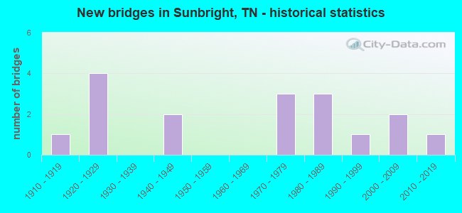
- New bridges - historical statistics
- 11910-1919
- 41920-1929
- 21940-1949
- 31970-1979
- 31980-1989
- 11990-1999
- 22000-2009
- 12010-2019
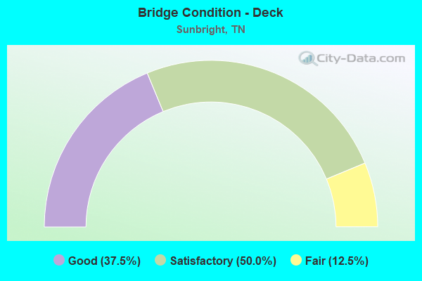
- Bridge Condition - Deck
- 37.5%Good
- 50.0%Satisfactory
- 12.5%Fair
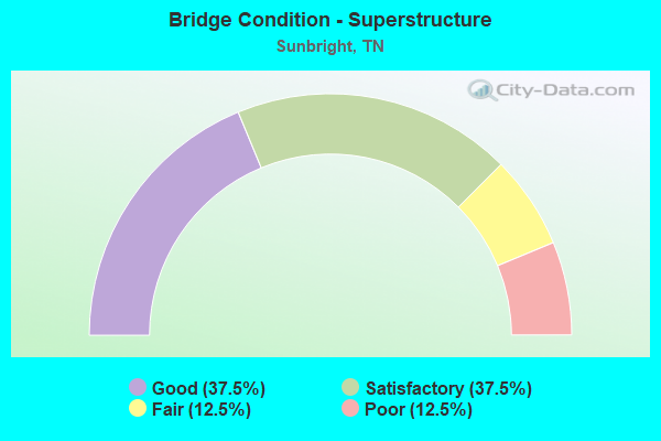
- Bridge Condition - Superstructure
- 37.5%Good
- 37.5%Satisfactory
- 12.5%Fair
- 12.5%Poor
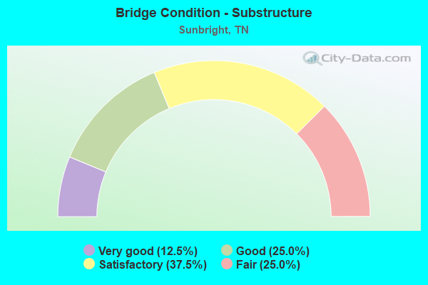
- Bridge Condition - Substructure
- 12.5%Very good
- 25.0%Good
- 37.5%Satisfactory
- 25.0%Fair
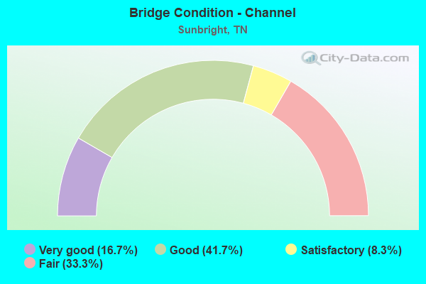
- Bridge Condition - Channel
- 16.7%Very good
- 41.7%Good
- 8.3%Satisfactory
- 33.3%Fair
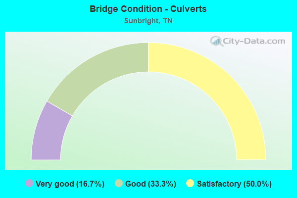
- Bridge Condition - Culverts
- 16.7%Very good
- 33.3%Good
- 50.0%Satisfactory
Find on map >> Show street view
Structure Number: 65023900001, Location: W OF US27 AT SUNBRIGHT (Lat: 36.244450, Lng: -84.673933), Route carried "on" structure: City street 2390, Year Built: 1984, Status: Open, Structure Length: 1.07m (3.51ft), Average Daily Traffic: 123 (year 2020), Truck Traffic: 4%, Average Future Daily Traffic: 224 (year 2041), Design Load: H 15, Features Intersected: PIGEON BRANCH
Minimum Vertical Clearance: 30+ m (98+ ft), Kilometerpoint: 0.113, Lanes on structure: 2, Owner: City or Municipal Highway Agency, Approaching Roadway Width: 7.9m (25.9ft), Skew: 1 degrees, Material/Design: Concrete, Design/Construction: Slab, Number Of Spans In Main Unit: 1, Length of Maximum Span: 9.4m (30.8ft), Curb-To-Curb Width: 8.0m (26.2ft), Out-to-Out Width: 9.1m (29.9ft)
Condition: Deck: Satisfactory, Superstructure: Fair, Substructure: Fair, Channel: Satisfactory, Operating Rating: 36.0 metric tons, Method Used To Determine Operating Rating: Field evaluation and documented engineering judgment, Inventory Rating: 24.3 metric tons, Method Used To Determine Inventory Rating: Field evaluation and documented engineering judgment, Structural Evaluation: Somewhat better than minimum adequacy, Deck Geometry: Somewhat better than minimum adequacy, Waterway Adequacy: Better than present minimum criteria, Approach Roadway Alignment: Equal to present minimum criteria, Length Of Structure Improvement: 1.07m (3.51ft), Designated Inspection Frequency: Every 24 months, Inspection Date: January 2021, Bridge Improvement Cost: $175,000, Roadway Improvement Cost: $18,000, Total Project Cost: $263,000 ( Estimate for 2021), Deck Structure Type: Concrete Cast-file-Place, Wearing Surface/Protective System: Wearing Surface: Monolithic Concrete
Find on map >> Show street view
Structure Number: 65023920003, Location: JUST NE OF SUNBRIGHT (Lat: 36.242933, Lng: -84.659017), Route carried "on" structure: County highway 2392, Year Built: 1995, Status: Open, Structure Length: 2.26m (7.41ft), Average Daily Traffic: 376 (year 2020), Truck Traffic: 3%, Average Future Daily Traffic: 576 (year 2041), Design Load: HS 20, Features Intersected: WHITEOAK CREEK
Minimum Vertical Clearance: 30+ m (98+ ft), Kilometerpoint: 1.159, Lanes on structure: 2, Owner: County Highway Agency, Approaching Roadway Width: 8.5m (27.9ft), Skew: 1 degrees, Material/Design: Prestressed concrete, Design/Construction: Box Beam or Girders - Single/Spread, Number Of Spans In Main Unit: 1, Length of Maximum Span: 21.0m (68.9ft), Curb-To-Curb Width: 9.8m (32.2ft), Out-to-Out Width: 9.9m (32.5ft)
Condition: Deck: Good, Superstructure: Good, Substructure: Good, Channel: Fair, Operating Rating: 63.9 metric tons, Method Used To Determine Operating Rating: Load Factor (LF), Inventory Rating: 32.4 metric tons, Method Used To Determine Inventory Rating: Load Factor (LF), Structural Evaluation: Better than present minimum criteria, Deck Geometry: Better than present minimum criteria, Waterway Adequacy: Better than present minimum criteria, Approach Roadway Alignment: Equal to present minimum criteria, Designated Inspection Frequency: Every 24 months, Inspection Date: January 2021, Deck Structure Type: Concrete Precast Panels, Wearing Surface/Protective System: Wearing Surface: Monolithic Concrete, Deck Protection: Epoxy Coated Reinforcing
Find on map >> Show street view
Structure Number: 65023940001, Location: 2.8 M N OF SUNBRIGHT (Lat: 36.281167, Lng: -84.682750), Route carried "on" structure: County highway 2394, Year Built: 1970, Status: Open, Structure Length: 1.98m (6.50ft), Average Daily Traffic: 655 (year 2020), Truck Traffic: 4%, Average Future Daily Traffic: 1,136 (year 2041), Design Load: H 15, Features Intersected: WHITE OAK CREEK
Minimum Vertical Clearance: 30+ m (98+ ft), Kilometerpoint: 4.152, Lanes on structure: 2, Owner: County Highway Agency, Approaching Roadway Width: 6.1m (20.0ft), Material/Design: Steel, Design/Construction: Culvert, Number Of Spans In Main Unit: 2, Length of Maximum Span: 6.4m (21.0ft)
Condition: Channel: Fair, Culverts: Satisfactory, Operating Rating: 69.3 metric tons, Method Used To Determine Operating Rating: Load Factor (LF), Inventory Rating: 32.4 metric tons, Method Used To Determine Inventory Rating: Load Factor (LF), Structural Evaluation: Equal to present minimum criteria, Waterway Adequacy: Somewhat better than minimum adequacy, Approach Roadway Alignment: Equal to present minimum criteria, Designated Inspection Frequency: Every 24 months, Inspection Date: January 2021, Wearing Surface/Protective System: Wearing Surface: Bituminous
Find on map >> Show street view
Structure Number: 65023940003, Location: 3 M NW OF SUNBRIGHT (Lat: 36.286617, Lng: -84.704050), Route carried "on" structure: County highway 2394, Year Built: 1941, Status: Open, Structure Length: 3.72m (12.20ft), Average Daily Traffic: 655 (year 2020), Truck Traffic: 4%, Average Future Daily Traffic: 1,136 (year 2041), Design Load: H 15, Features Intersected: BONE CAMP CREEK
Minimum Vertical Clearance: 30+ m (98+ ft), Kilometerpoint: 6.759, Lanes on structure: 2, Owner: County Highway Agency, Approaching Roadway Width: 9.8m (32.2ft), Material/Design: Steel, Design/Construction: Stringer/Multi-beam, Number Of Spans In Main Unit: 3, Length of Maximum Span: 16.2m (53.1ft), Curb-To-Curb Width: 6.1m (20.0ft), Out-to-Out Width: 6.4m (21.0ft)
Condition: Deck: Fair, Superstructure: Satisfactory, Substructure: Satisfactory, Channel: Fair, Operating Rating: 35.1 metric tons, Method Used To Determine Operating Rating: Load Factor (LF), Inventory Rating: 27.9 metric tons, Method Used To Determine Inventory Rating: Load Factor (LF), Structural Evaluation: Equal to present minimum criteria, Deck Geometry: High priority of corrective action, Waterway Adequacy: Better than present minimum criteria, Approach Roadway Alignment: Equal to present minimum criteria, Length Of Structure Improvement: 3.72m (12.20ft), Designated Inspection Frequency: Every 24 months, Inspection Date: January 2021, Bridge Improvement Cost: $347,000, Roadway Improvement Cost: $35,000, Total Project Cost: $521,000 ( Estimate for 2021), Deck Structure Type: Concrete Cast-file-Place, Wearing Surface/Protective System: Wearing Surface: Bituminous
Find on map >> Show street view
Structure Number: 650A1560003, Location: W OFF US27-N OF LANCING (Lat: 36.177000, Lng: -84.666067), Route carried "on" structure: County highway 156, Year Built: 1984, Status: Open, Structure Length: 0.76m (2.49ft), Average Daily Traffic: 80 (year 2022), Truck Traffic: 2%, Average Future Daily Traffic: 128 (year 2041), Design Load: HS 20+Mod, Features Intersected: ROCK CREEK
Minimum Vertical Clearance: 4.19m (13.75ft), Kilometerpoint: 0.850, Lanes on structure: 2, Owner: County Highway Agency, Approaching Roadway Width: 7.0m (23.0ft), Skew: 6 degrees, Material/Design: Concrete, Design/Construction: Culvert, Number Of Spans In Main Unit: 1, Length of Maximum Span: 5.5m (18.0ft), Curb-To-Curb Width: 8.7m (28.5ft), Out-to-Out Width: 12.9m (42.3ft)
Condition: Channel: Fair, Culverts: Satisfactory, Operating Rating: 44.1 metric tons, Method Used To Determine Operating Rating: Assigned rating based on Load Factor Design (LFD) reported in metric tons, Inventory Rating: 32.4 metric tons, Method Used To Determine Inventory Rating: Assigned rating based on Load Factor Design (LFD) reported in metric tons, Structural Evaluation: Equal to present minimum criteria, Deck Geometry: Better than present minimum criteria, Waterway Adequacy: Better than present minimum criteria, Approach Roadway Alignment: Equal to present minimum criteria, Designated Inspection Frequency: Every 24 months, Inspection Date: January 2021, Deck Structure Type: Concrete Cast-file-Place, Wearing Surface/Protective System: Wearing Surface: Bituminous
Find on map >> Show street view
Structure Number: 650A1560005, Location: W OF US27 N OF LANCING (Lat: 36.173750, Lng: -84.673733), Route carried "on" structure: County highway 156, Year Built: 2000, Status: Open, Structure Length: 0.91m (2.99ft), Average Daily Traffic: 80 (year 2022), Truck Traffic: 2%, Average Future Daily Traffic: 128 (year 2041), Design Load: HS 20, Features Intersected: BOBS CREEK
Minimum Vertical Clearance: 30+ m (98+ ft), Kilometerpoint: 1.859, Lanes on structure: 2, Owner: County Highway Agency, Approaching Roadway Width: 6.7m (22.0ft), Skew: 1 degrees, Material/Design: Concrete, Design/Construction: Culvert, Number Of Spans In Main Unit: 1, Length of Maximum Span: 7.9m (25.9ft), Curb-To-Curb Width: 7.4m (24.3ft), Out-to-Out Width: 8.4m (27.6ft)
Condition: Channel: Good, Culverts: Good, Operating Rating: 44.1 metric tons, Method Used To Determine Operating Rating: Assigned rating based on Load Factor Design (LFD) reported in metric tons, Inventory Rating: 32.4 metric tons, Method Used To Determine Inventory Rating: Assigned rating based on Load Factor Design (LFD) reported in metric tons, Structural Evaluation: Better than present minimum criteria, Waterway Adequacy: Better than present minimum criteria, Approach Roadway Alignment: Equal to present desirable criteria, Designated Inspection Frequency: Every 24 months, Inspection Date: January 2021, Deck Structure Type: Concrete Cast-file-Place, Wearing Surface/Protective System: Wearing Surface: Bituminous, Deck Protection: Epoxy Coated Reinforcing
Find on map >> Show street view
Structure Number: 650A1730001, Location: 3 M W OF SUNBRIGHT (Lat: 36.241117, Lng: -84.725650), Route carried "on" structure: County highway 173, Year Built: 1986, Status: Open, Structure Length: 3.75m (12.30ft), Average Daily Traffic: 200 (year 2022), Truck Traffic: 2%, Average Future Daily Traffic: 320 (year 2041), Design Load: HS 20, Features Intersected: BONE CAMP CREEK
Minimum Vertical Clearance: 30+ m (98+ ft), Kilometerpoint: 3.743, Lanes on structure: 2, Owner: County Highway Agency, Approaching Roadway Width: 6.7m (22.0ft), Material/Design: Prestressed concrete continuous, Design/Construction: Stringer/Multi-beam, Number Of Spans In Main Unit: 3, Length of Maximum Span: 12.5m (41.0ft), Curb-To-Curb Width: 6.7m (22.0ft), Out-to-Out Width: 7.4m (24.3ft)
Condition: Deck: Good, Superstructure: Good, Substructure: Very good, Channel: Good, Operating Rating: 57.6 metric tons, Method Used To Determine Operating Rating: Load Factor (LF), Inventory Rating: 32.4 metric tons, Method Used To Determine Inventory Rating: Load Factor (LF), Structural Evaluation: Better than present minimum criteria, Deck Geometry: Meets minimum limits, Waterway Adequacy: Equal to present desirable criteria, Approach Roadway Alignment: High priority of corrective action, Designated Inspection Frequency: Every 24 months, Inspection Date: Febuary 2021, Deck Structure Type: Concrete Precast Panels, Wearing Surface/Protective System: Wearing Surface: Monolithic Concrete
Find on map >> Show street view
Structure Number: 650A2240001, Location: AT SUNBRIGHT E OF US27 (Lat: 36.240000, Lng: -84.668350), Route carried "on" structure: City street 224, Year Built: 1975, Status: Open, Structure Length: 3.11m (10.20ft), Average Daily Traffic: 430 (year 2022), Truck Traffic: 2%, Average Future Daily Traffic: 688 (year 2041), Features Intersected: SOUTHERN RAILWAY
Minimum Vertical Clearance: 30+ m (98+ ft), Kilometerpoint: 3.730, Lanes on structure: 2, Owner: City or Municipal Highway Agency, Approaching Roadway Width: 5.5m (18.0ft), Material/Design: Prestressed concrete, Design/Construction: Box Beam or Girders - Multiple, Number Of Spans In Main Unit: 1, Length of Maximum Span: 30.2m (99.1ft), Curb-To-Curb Width: 5.9m (19.4ft), Out-to-Out Width: 6.5m (21.3ft)
Condition: Deck: Satisfactory, Superstructure: Satisfactory, Substructure: Fair, Operating Rating: 44.1 metric tons, Method Used To Determine Operating Rating: Field evaluation and documented engineering judgment, Inventory Rating: 32.4 metric tons, Method Used To Determine Inventory Rating: Field evaluation and documented engineering judgment, Structural Evaluation: Somewhat better than minimum adequacy, Deck Geometry: High priority of replacement, Underclear: Equal to present minimum criteria, Approach Roadway Alignment: High priority of corrective action, Length Of Structure Improvement: 3.11m (10.20ft), Designated Inspection Frequency: Every 24 months, Inspection Date: January 2021, Bridge Improvement Cost: $300,000, Roadway Improvement Cost: $31,000, Total Project Cost: $451,000 ( Estimate for 2021), Deck Structure Type: Other, Wearing Surface/Protective System: Wearing Surface: Bituminous
Find on map >> Show street view
Structure Number: 65S23430001, Location: .1 E OF SUNBRIGHT (Lat: 36.236117, Lng: -84.681833), Route carried "on" structure: State highway 329, Year Built: 2007, Status: Open, Structure Length: 1.34m (4.40ft), Average Daily Traffic: 615 (year 2020), Truck Traffic: 4%, Average Future Daily Traffic: 984 (year 2041), Design Load: HS 20+Mod, Features Intersected: BRANCH
Minimum Vertical Clearance: 30+ m (98+ ft), Kilometerpoint: 14.034, Lanes on structure: 2, Owner: State Highway Agency, Approaching Roadway Width: 8.5m (27.9ft), Skew: 3 degrees, Material/Design: Concrete continuous, Design/Construction: Culvert, Number Of Spans In Main Unit: 2, Length of Maximum Span: 6.6m (21.7ft), Curb-To-Curb Width: 9.3m (30.5ft), Out-to-Out Width: 10.2m (33.5ft)
Condition: Channel: Very good, Culverts: Good, Operating Rating: 89.1 metric tons, Method Used To Determine Operating Rating: Load Factor (LF), Inventory Rating: 32.4 metric tons, Method Used To Determine Inventory Rating: Load Factor (LF), Structural Evaluation: Better than present minimum criteria, Deck Geometry: Equal to present minimum criteria, Waterway Adequacy: Superior to present desirable criteria, Approach Roadway Alignment: Equal to present minimum criteria, Designated Inspection Frequency: Every 24 months, Inspection Date: May 2021, Deck Structure Type: Concrete Cast-file-Place, Wearing Surface/Protective System: Wearing Surface: Bituminous
Find on map >> Show street view
Structure Number: 65SR0290025, Location: 8.60 MI.S.OF SCOTT CO. (Lat: 36.197300, Lng: -84.660000), Route carried "on" structure: US 27, Year Built: 1928, Status: Open, Structure Length: 0.76m (2.49ft), Average Daily Traffic: 4,994 (year 2020), Truck Traffic: 11%, Average Future Daily Traffic: 7,990 (year 2041), Design Load: H 15, Features Intersected: GARRETT BRANCH, Facility Carried by Structure: FAP 29
Minimum Vertical Clearance: 30+ m (98+ ft), Kilometerpoint: 31.656, Lanes on structure: 2, Base Highway Network: Yes, Owner: State Highway Agency, Approaching Roadway Width: 9.1m (29.9ft), Skew: 2 degrees, Material/Design: Concrete continuous, Design/Construction: Culvert, Number Of Spans In Main Unit: 2, Length of Maximum Span: 3.4m (11.2ft), Curb-To-Curb Width: 9.1m (29.9ft), Out-to-Out Width: 10.5m (34.4ft)
Condition: Channel: Very good, Culverts: Satisfactory, Operating Rating: 36.0 metric tons, Method Used To Determine Operating Rating: Field evaluation and documented engineering judgment, Inventory Rating: 24.3 metric tons, Method Used To Determine Inventory Rating: Field evaluation and documented engineering judgment, Structural Evaluation: Equal to present minimum criteria, Deck Geometry: Meets minimum limits, Waterway Adequacy: Better than present minimum criteria, Approach Roadway Alignment: Equal to present desirable criteria, Length Of Structure Improvement: 0.76m (2.49ft), Designated Inspection Frequency: Every 24 months, Inspection Date: April 2021, Bridge Improvement Cost: $64,000, Roadway Improvement Cost: $7,000, Total Project Cost: $97,000 ( Estimate for 2021), Deck Structure Type: Concrete Cast-file-Place, Wearing Surface/Protective System: Wearing Surface: Bituminous
Find on map >> Show street view
Structure Number: 65SR0290027, Location: NEAR PILOT MT. (Lat: 36.198417, Lng: -84.660533), Route carried "on" structure: US 27, Year Built: 1928, Year Reconstructed: 1972, Status: Open, Structure Length: 2.41m (7.91ft), Average Daily Traffic: 4,994 (year 2020), Truck Traffic: 11%, Average Future Daily Traffic: 7,990 (year 2041), Design Load: HS 20, Features Intersected: ROCK CREEK, Facility Carried by Structure: FAP 29
Minimum Vertical Clearance: 30+ m (98+ ft), Kilometerpoint: 31.793, Lanes on structure: 2, Base Highway Network: Yes, Owner: State Highway Agency, Approaching Roadway Width: 14.6m (47.9ft), Material/Design: Concrete, Design/Construction: Arch - Deck, Number Of Spans In Main Unit: 2, Length of Maximum Span: 8.2m (26.9ft), Curb-To-Curb Width: 14.6m (47.9ft), Out-to-Out Width: 15.2m (49.9ft)
Condition: Deck: Satisfactory, Superstructure: Satisfactory, Substructure: Satisfactory, Channel: Good, Operating Rating: 44.1 metric tons, Method Used To Determine Operating Rating: Assigned rating based on Load Factor Design (LFD) reported in metric tons, Inventory Rating: 32.4 metric tons, Method Used To Determine Inventory Rating: Assigned rating based on Load Factor Design (LFD) reported in metric tons, Structural Evaluation: Equal to present minimum criteria, Deck Geometry: Superior to present desirable criteria, Waterway Adequacy: Equal to present minimum criteria, Approach Roadway Alignment: Equal to present minimum criteria, Designated Inspection Frequency: Every 24 months, Inspection Date: April 2021, Deck Structure Type: Concrete Cast-file-Place, Wearing Surface/Protective System: Wearing Surface: Bituminous
Find on map >> Show street view
Structure Number: 65SR0290029, Location: 9.22 MI.N.OF WARTBURG (Lat: 36.217983, Lng: -84.666900), Route carried "on" structure: US 27, Year Built: 1975, Status: Open, Structure Length: 11.61m (38.09ft), Average Daily Traffic: 2,849 (year 2020), Truck Traffic: 11%, Average Future Daily Traffic: 4,558 (year 2041), Design Load: H 15, Features Intersected: SOUTHERN RAILWAY, Facility Carried by Structure: FAP 29 841854N
Minimum Vertical Clearance: 30+ m (98+ ft), Kilometerpoint: 34.102, Lanes on structure: 2, Base Highway Network: Yes, Owner: State Highway Agency, Approaching Roadway Width: 14.6m (47.9ft), Skew: 3 degrees, Material/Design: Prestressed concrete continuous, Design/Construction: Box Beam or Girders - Single/Spread, Number Of Spans In Main Unit: 4, Length of Maximum Span: 30.5m (100.1ft), Curb-To-Curb Width: 14.6m (47.9ft), Out-to-Out Width: 15.2m (49.9ft)
Condition: Deck: Good, Superstructure: Good, Substructure: Good, Operating Rating: 81.0 metric tons, Method Used To Determine Operating Rating: Load Factor (LF), Inventory Rating: 32.4 metric tons, Method Used To Determine Inventory Rating: Load Factor (LF), Structural Evaluation: Better than present minimum criteria, Deck Geometry: Superior to present desirable criteria, Underclear: Superior to present desirable criteria, Approach Roadway Alignment: Equal to present minimum criteria, Length Of Structure Improvement: 11.61m (38.09ft), Designated Inspection Frequency: Every 24 months, Inspection Date: April 2021, Bridge Improvement Cost: $2,801,000, Roadway Improvement Cost: $281,000, Total Project Cost: $4,202,000 ( Estimate for 2021), Deck Structure Type: Concrete Cast-file-Place, Wearing Surface/Protective System: Wearing Surface: Bituminous, Membrane: Preformed Fabric
Find on map >> Show street view
Structure Number: 65SR0290031, Location: 5.22 MI.S.OF SCOTT CO. (Lat: 36.244033, Lng: -84.670150), Route carried "on" structure: US 27, Year Built: 2011, Status: Open, Structure Length: 1.74m (5.71ft), Average Daily Traffic: 2,710 (year 2020), Truck Traffic: 11%, Average Future Daily Traffic: 4,336 (year 2041), Design Load: HL 93, Features Intersected: WHITE OAK CREEK, Facility Carried by Structure: FAP 29
Minimum Vertical Clearance: 30+ m (98+ ft), Kilometerpoint: 37.096, Lanes on structure: 2, Base Highway Network: Yes, Owner: State Highway Agency, Approaching Roadway Width: 11.3m (37.1ft), Material/Design: Concrete continuous, Design/Construction: Culvert, Number Of Spans In Main Unit: 3, Length of Maximum Span: 8.7m (28.5ft), Curb or Sidewalk Widths: Left: 0.8m (2.6ft), Right: 0.8m (2.6ft), Curb-To-Curb Width: 13.1m (43.0ft), Out-to-Out Width: 14.7m (48.2ft)
Condition: Channel: Good, Culverts: Very good, Operating Rating: 89.1 metric tons, Method Used To Determine Operating Rating: Load Factor (LF), Inventory Rating: 32.4 metric tons, Method Used To Determine Inventory Rating: Load Factor (LF), Structural Evaluation: Equal to present desirable criteria, Deck Geometry: Equal to present minimum criteria, Waterway Adequacy: Equal to present minimum criteria, Approach Roadway Alignment: Equal to present minimum criteria, Length Of Structure Improvement: 1.74m (5.71ft), Designated Inspection Frequency: Every 24 months, Inspection Date: April 2021, Bridge Improvement Cost: $393,000, Roadway Improvement Cost: $40,000, Total Project Cost: $590,000 ( Estimate for 2021), Deck Structure Type: Concrete Cast-file-Place, Wearing Surface/Protective System: Wearing Surface: Bituminous
Find on map >> Show street view
Structure Number: 65SR0290033, Location: 2.14 MI.S.OF SCOTT CO. (Lat: 36.282050, Lng: -84.657950), Route carried "on" structure: US 27, Year Built: 1927, Year Reconstructed: 1965, Status: Posted for load, Structure Length: 0.88m (2.89ft), Average Daily Traffic: 1,700 (year 2020), Truck Traffic: 11%, Average Future Daily Traffic: 2,720 (year 2041), Design Load: H 15, Features Intersected: MASSINGALE CREEK, Facility Carried by Structure: FAP 29
Minimum Vertical Clearance: 30+ m (98+ ft), Kilometerpoint: 42.068, Lanes on structure: 2, Base Highway Network: Yes, Owner: State Highway Agency, Approaching Roadway Width: 11.0m (36.1ft), Material/Design: Concrete, Design/Construction: Tee Beam, Number Of Spans In Main Unit: 1, Length of Maximum Span: 8.5m (27.9ft), Curb-To-Curb Width: 11.0m (36.1ft), Out-to-Out Width: 11.6m (38.1ft)
Condition: Deck: Satisfactory, Superstructure: Poor, Substructure: Satisfactory, Channel: Good, Operating Rating: 47.7 metric tons, Method Used To Determine Operating Rating: Load Factor (LF), Inventory Rating: 28.8 metric tons, Method Used To Determine Inventory Rating: Load Factor (LF), Structural Evaluation: Meets minimum limits, Deck Geometry: Equal to present minimum criteria, Waterway Adequacy: Equal to present minimum criteria, Approach Roadway Alignment: Equal to present desirable criteria, Length Of Structure Improvement: 0.88m (2.89ft), Designated Inspection Frequency: Every 24 months, Inspection Date: April 2021, Bridge Improvement Cost: $175,000, Roadway Improvement Cost: $18,000, Total Project Cost: $263,000 ( Estimate for 2021), Deck Structure Type: Concrete Cast-file-Place, Wearing Surface/Protective System: Wearing Surface: Bituminous
Find on map >> Show street view
Structure Number: 65023920001, Location: JUST NE OF SUNBRIGHT (Lat: 36.243267, Lng: -84.665250), Route carried "under" structure: City street 2392, Year Built: 1940, Structure Length: 0. m, Average Daily Traffic: 376 (year 2020), Truck Traffic: 3%, Features Intersected: S. RAILWAY/MILL CR. RD, Facility Carried by Structure: SOU RWY 841851T
Minimum Vertical Clearance: 3.56m (11.68ft), Kilometerpoint: 0.499, Lanes under structure: 1, Material/Design: Concrete, Design/Construction: Slab, Length of Maximum Span: 7.9m (25.9ft)
Find on map >> Show street view
Structure Number: 650A1560001, Location: W OF US27-N OF LANCING (Lat: 36.177000, Lng: -84.666183), Route carried "under" structure: City street 156, Year Built: 1919, Structure Length: 0. m, Average Daily Traffic: 80 (year 2022), Truck Traffic: 2%, Features Intersected: SOUTHERN RAILWAYANNADEL, Facility Carried by Structure: SOU RWY 841856C
Minimum Vertical Clearance: 4.20m (13.78ft), Kilometerpoint: 0.840, Lanes under structure: 2, Material/Design: Concrete, Design/Construction: Stringer/Multi-beam, Length of Maximum Span: 10.7m (35.1ft)
Find on map >> Show street view
Structure Number: 650A1570001, Location: W OF US27-S OF SUNBRIGHT (Lat: 36.199450, Lng: -84.663350), Route carried "under" structure: Federal lands road 157, Year Built: 1920, Structure Length: 0. m, Average Daily Traffic: 550 (year 2022), Truck Traffic: 2%, Features Intersected: S. RAILWAY/PILOT MTN. RD, Facility Carried by Structure: SOU RWY 841855V
Minimum Vertical Clearance: 3.76m (12.34ft), Kilometerpoint: 0.235, Lanes under structure: 1, Material/Design: Concrete, Design/Construction: Slab, Length of Maximum Span: 4.9m (16.1ft)