Bridge Statistics for Swan Lake, Montana (MT)
Condition, Traffic, Stress, Structural Evaluation, Project Costs
- National Bridge Inventory (NBI) Statistics
- 10Number of bridges
- 56ft / 16.9mTotal length
- $57,000Total costs
- 5,570Total average daily traffic
- 449Total average daily truck traffic
- 6,198Total future (year 2040) average daily traffic
- National Bridge Inventory (NBI) Registered Bridges for Swan Lake
- No street view available for this location
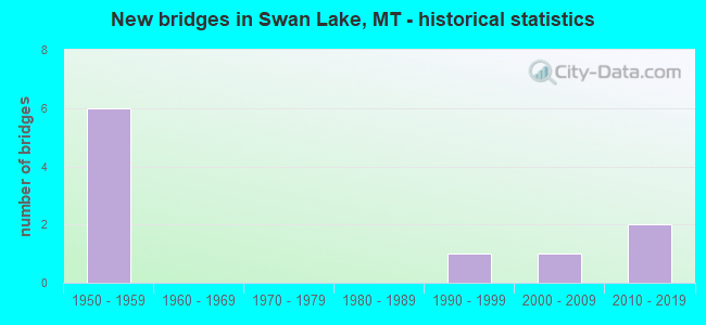
- New bridges - historical statistics
- 61950-1959
- 11990-1999
- 12000-2009
- 22010-2019
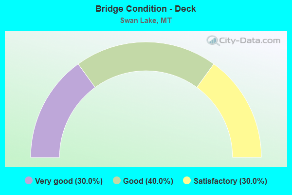
- Bridge Condition - Deck
- 30.0%Very good
- 40.0%Good
- 30.0%Satisfactory
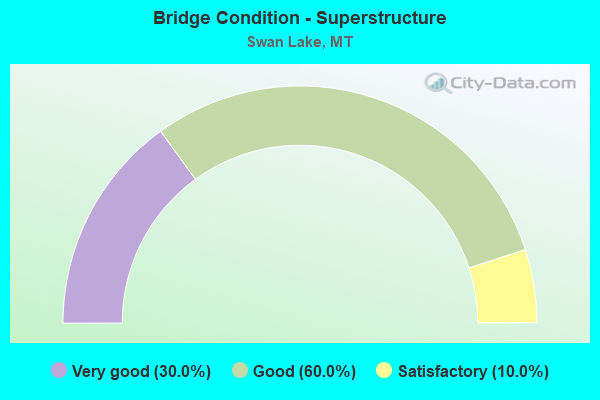
- Bridge Condition - Superstructure
- 30.0%Very good
- 60.0%Good
- 10.0%Satisfactory
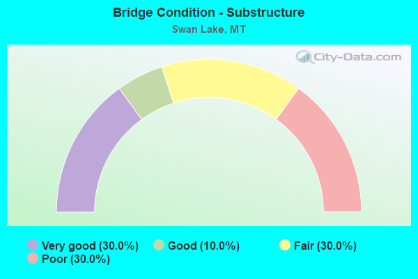
- Bridge Condition - Substructure
- 30.0%Very good
- 10.0%Good
- 30.0%Fair
- 30.0%Poor
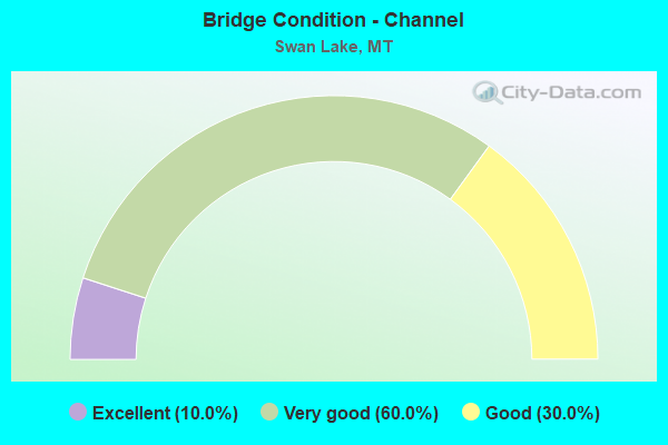
- Bridge Condition - Channel
- 10.0%Excellent
- 60.0%Very good
- 30.0%Good
Find on map >> Show street view
Structure Number: 11001000000109, Location: PORCUPINE CREEK ROAD (Lat: 47.886664, Lng: -113.860467), Route carried "on" structure: Federal lands road 10229, Year Built: 1956, Status: Open, Structure Length: 7.04m (23.10ft), Average Daily Traffic: 20 (year 1992), Average Future Daily Traffic: 30 (year 2042), Design Load: HS 25 or greater, Features Intersected: SWAN RIVER, Facility Carried by Structure: FOREST ROAD
Minimum Vertical Clearance: 30+ m (98+ ft), Kilometerpoint: 2.088, Lanes on structure: 1, Owner: U.S. Forest Service, Approaching Roadway Width: 4.9m (16.1ft), Material/Design: Steel, Design/Construction: Stringer/Multi-beam, Number Of Spans In Main Unit: 3, Length of Maximum Span: 27.7m (90.9ft), Curb or Sidewalk Widths: Left: 0.2m (0.7ft), Right: 0.2m (0.7ft), Curb-To-Curb Width: 4.3m (14.1ft), Out-to-Out Width: 4.7m (15.4ft)
Condition: Deck: Satisfactory, Superstructure: Satisfactory, Substructure: Poor, Channel: Good, Operating Rating: 53.1 metric tons, Method Used To Determine Operating Rating: Load and Resistance Factor Rating (LRFR) rating reported by rating factor(RF) method using HL-93 loadings, Inventory Rating: 40.8 metric tons, Method Used To Determine Inventory Rating: Load and Resistance Factor Rating (LRFR) rating reported by rating factor(RF) method using HL-93 loadings, Structural Evaluation: Meets minimum limits, Deck Geometry: Equal to present minimum criteria, Waterway Adequacy: Superior to present desirable criteria, Approach Roadway Alignment: Equal to present desirable criteria, Designated Inspection Frequency: Every 24 months, Inspection Date: September 2021, Deck Structure Type: Wood or Timber, Wearing Surface/Protective System: Wearing Surface: Wood or Timber
Find on map >> Show street view
Structure Number: 11001000001254, Location: SWAN LAKE CAMPGROUND (Lat: 47.935981, Lng: -113.844242), Route carried "on" structure: Federal lands road 1073, Year Built: 1997, Status: Open, Structure Length: 0.85m (2.79ft), Average Daily Traffic: 50 (year 1997), Average Future Daily Traffic: 75 (year 2042), Design Load: H 20, Features Intersected: HALL CREEK, Facility Carried by Structure: FOREST ROAD
Minimum Vertical Clearance: 30+ m (98+ ft), Kilometerpoint: 0.712, Lanes on structure: 1, Owner: U.S. Forest Service, Approaching Roadway Width: 5.5m (18.0ft), Skew: 1 degrees, Material/Design: Prestressed concrete, Design/Construction: Stringer/Multi-beam, Number Of Spans In Main Unit: 1, Length of Maximum Span: 8.0m (26.2ft), Curb or Sidewalk Widths: Left: 0.3m (1.0ft), Right: 1.5m (4.9ft), Curb-To-Curb Width: 4.3m (14.1ft), Out-to-Out Width: 6.1m (20.0ft)
Condition: Deck: Good, Superstructure: Good, Substructure: Good, Channel: Good, Operating Rating: 25.9 metric tons, Method Used To Determine Operating Rating: Load and Resistance Factor Rating (LRFR) rating reported by rating factor(RF) method using HL-93 loadings, Inventory Rating: 20.4 metric tons, Method Used To Determine Inventory Rating: Load and Resistance Factor Rating (LRFR) rating reported by rating factor(RF) method using HL-93 loadings, Structural Evaluation: Somewhat better than minimum adequacy, Deck Geometry: Equal to present minimum criteria, Waterway Adequacy: Superior to present desirable criteria, Approach Roadway Alignment: Equal to present desirable criteria, Designated Inspection Frequency: Every 24 months, Inspection Date: October 2020, Deck Structure Type: Concrete Precast Panels, Wearing Surface/Protective System: Wearing Surface: Monolithic Concrete
Find on map >> Show street view
Structure Number: 11001000003027, Location: NORTH FORK LOST CREEK (Lat: 47.897731, Lng: -113.738536), Route carried "on" structure: Federal lands road 5206, Year Built: 2005, Status: Open, Structure Length: 1.04m (3.41ft), Average Daily Traffic: 30 (year 2003), Average Future Daily Traffic: 45 (year 2042), Design Load: HS 20, Features Intersected: CREEK, Facility Carried by Structure: FOREST ROAD
Minimum Vertical Clearance: 30+ m (98+ ft), Kilometerpoint: 5.728, Lanes on structure: 1, Owner: U.S. Forest Service, Approaching Roadway Width: 4.9m (16.1ft), Material/Design: Prestressed concrete, Design/Construction: Slab, Number Of Spans In Main Unit: 1, Length of Maximum Span: 10.1m (33.1ft), Curb or Sidewalk Widths: Left: 0.3m (1.0ft), Right: 0.3m (1.0ft), Curb-To-Curb Width: 4.3m (14.1ft), Out-to-Out Width: 4.9m (16.1ft)
Condition: Deck: Very good, Superstructure: Very good, Substructure: Very good, Channel: Very good, Operating Rating: 33.7 metric tons, Method Used To Determine Operating Rating: Load and Resistance Factor Rating (LRFR) rating reported by rating factor(RF) method using HL-93 loadings, Inventory Rating: 25.9 metric tons, Method Used To Determine Inventory Rating: Load and Resistance Factor Rating (LRFR) rating reported by rating factor(RF) method using HL-93 loadings, Structural Evaluation: Equal to present minimum criteria, Deck Geometry: Equal to present minimum criteria, Waterway Adequacy: Superior to present desirable criteria, Approach Roadway Alignment: Equal to present desirable criteria, Designated Inspection Frequency: Every 48 months, Inspection Date: August 2021, Deck Structure Type: Concrete Precast Panels, Wearing Surface/Protective System: Wearing Surface: Monolithic Concrete, Membrane: Epoxy
Find on map >> Show street view
Structure Number: 11001000016329, Location: SOUTH LOST (Lat: 47.884939, Lng: -113.798850), Route carried "on" structure: Federal lands road 680, Year Built: 2014, Status: Open, Structure Length: 1.83m (6.00ft), Average Daily Traffic: 40 (year 0000), Average Future Daily Traffic: 60 (year 2042), Design Load: HL 93, Features Intersected: NORTH FORK LOST CREEK, Facility Carried by Structure: FOREST ROAD
Minimum Vertical Clearance: 30+ m (98+ ft), Kilometerpoint: 3.736, Lanes on structure: 1, Owner: U.S. Forest Service, Approaching Roadway Width: 4.3m (14.1ft), Material/Design: Prestressed concrete, Design/Construction: Stringer/Multi-beam, Number Of Spans In Main Unit: 1, Length of Maximum Span: 17.4m (57.1ft), Curb or Sidewalk Widths: Left: 0.3m (1.0ft), Right: 0.3m (1.0ft), Curb-To-Curb Width: 4.3m (14.1ft), Out-to-Out Width: 4.9m (16.1ft)
Condition: Deck: Very good, Superstructure: Very good, Substructure: Very good, Channel: Very good, Operating Rating: 38.9 metric tons, Method Used To Determine Operating Rating: Load and Resistance Factor Rating (LRFR) rating reported by rating factor(RF) method using HL-93 loadings, Inventory Rating: 30.1 metric tons, Method Used To Determine Inventory Rating: Load and Resistance Factor Rating (LRFR) rating reported by rating factor(RF) method using HL-93 loadings, Structural Evaluation: Better than present minimum criteria, Deck Geometry: Equal to present minimum criteria, Waterway Adequacy: Superior to present desirable criteria, Approach Roadway Alignment: Equal to present desirable criteria, Designated Inspection Frequency: Every 48 months, Inspection Date: August 2018, Deck Structure Type: Concrete Precast Panels, Wearing Surface/Protective System: Wearing Surface: Monolithic Concrete
Find on map >> Show street view
Structure Number: 11001000016919, Location: NORTH LOST (Lat: 47.895125, Lng: -113.745186), Route carried "on" structure: Federal lands road 5206, Year Built: 2015, Status: Open, Structure Length: 1.83m (6.00ft), Average Daily Traffic: 40 (year 0000), Average Future Daily Traffic: 60 (year 2042), Design Load: HL 93, Features Intersected: NORTH FORK LOST CREEK, Facility Carried by Structure: FOREST ROAD
Minimum Vertical Clearance: 30+ m (98+ ft), Kilometerpoint: 5.160, Lanes on structure: 1, Owner: U.S. Forest Service, Approaching Roadway Width: 4.3m (14.1ft), Skew: 2 degrees, Material/Design: Prestressed concrete, Design/Construction: Stringer/Multi-beam, Number Of Spans In Main Unit: 1, Length of Maximum Span: 17.7m (58.1ft), Curb or Sidewalk Widths: Left: 0.3m (1.0ft), Right: 0.3m (1.0ft), Curb-To-Curb Width: 4.9m (16.1ft), Out-to-Out Width: 5.5m (18.0ft)
Condition: Deck: Very good, Superstructure: Very good, Substructure: Very good, Channel: Excellent, Operating Rating: 36.3 metric tons, Method Used To Determine Operating Rating: Load and Resistance Factor Rating (LRFR) rating reported by rating factor(RF) method using HL-93 loadings, Inventory Rating: 28.2 metric tons, Method Used To Determine Inventory Rating: Load and Resistance Factor Rating (LRFR) rating reported by rating factor(RF) method using HL-93 loadings, Structural Evaluation: Better than present minimum criteria, Deck Geometry: High priority of corrective action, Waterway Adequacy: Equal to present desirable criteria, Approach Roadway Alignment: Equal to present minimum criteria, Designated Inspection Frequency: Every 48 months, Inspection Date: August 2021, Deck Structure Type: Concrete Precast Panels, Wearing Surface/Protective System: Wearing Surface: Bituminous
Find on map >> Show street view
Structure Number: P00083067+02881, Location: 3M S SWAN LAKE (Lat: 47.873794, Lng: -113.834261), Route carried "on" structure: State highway 83, Year Built: 1953, Status: Open, Structure Length: 1.77m (5.81ft), Average Daily Traffic: 938 (year 2020), Truck Traffic: 10%, Average Future Daily Traffic: 1,032 (year 2040), Design Load: HS 20, Features Intersected: LOST CREEK
Minimum Vertical Clearance: 30+ m (98+ ft), Kilometerpoint: 108.267, Lanes on structure: 2, Base Highway Network: Yes, Owner: State Highway Agency, Approaching Roadway Width: 7.3m (24.0ft), Material/Design: Wood or Timber, Design/Construction: Stringer/Multi-beam, Number Of Spans In Main Unit: 3, Length of Maximum Span: 5.8m (19.0ft), Curb or Sidewalk Widths: Left: 0.6m (2.0ft), Right: 0.6m (2.0ft), Curb-To-Curb Width: 7.9m (25.9ft), Out-to-Out Width: 9.4m (30.8ft)
Condition: Deck: Good, Superstructure: Good, Substructure: Fair, Channel: Very good, Operating Rating: 41.5 metric tons, Method Used To Determine Operating Rating: Allowable Stress (AS), Inventory Rating: 28.9 metric tons, Method Used To Determine Inventory Rating: Allowable Stress (AS), Structural Evaluation: Somewhat better than minimum adequacy, Deck Geometry: Somewhat better than minimum adequacy, Waterway Adequacy: Equal to present desirable criteria, Approach Roadway Alignment: Equal to present desirable criteria, Designated Inspection Frequency: Every 24 months, Inspection Date: July 2020, Deck Structure Type: Wood or Timber, Wearing Surface/Protective System: Wearing Surface: Bituminous
Find on map >> Show street view
Structure Number: P00083070+06501, Location: SWAN LAKE (Lat: 47.916828, Lng: -113.838572), Route carried "on" structure: State highway 83, Year Built: 1958, Status: Open, Structure Length: 0.64m (2.10ft), Average Daily Traffic: 1,113 (year 2020), Truck Traffic: 8%, Average Future Daily Traffic: 1,224 (year 2040), Design Load: HS 20, Features Intersected: BOND CREEK
Minimum Vertical Clearance: 30+ m (98+ ft), Kilometerpoint: 113.231, Lanes on structure: 2, Base Highway Network: Yes, Owner: State Highway Agency, Approaching Roadway Width: 7.9m (25.9ft), Material/Design: Wood or Timber, Design/Construction: Stringer/Multi-beam, Number Of Spans In Main Unit: 1, Length of Maximum Span: 5.8m (19.0ft), Curb or Sidewalk Widths: Left: 0.6m (2.0ft), Right: 0.6m (2.0ft), Curb-To-Curb Width: 8.0m (26.2ft), Out-to-Out Width: 9.4m (30.8ft)
Condition: Deck: Good, Superstructure: Good, Substructure: Fair, Channel: Good, Operating Rating: 64.0 metric tons, Method Used To Determine Operating Rating: Allowable Stress (AS), Inventory Rating: 45.7 metric tons, Method Used To Determine Inventory Rating: Allowable Stress (AS), Structural Evaluation: Somewhat better than minimum adequacy, Deck Geometry: Meets minimum limits, Waterway Adequacy: High priority of corrective action, Approach Roadway Alignment: Equal to present desirable criteria, Length Of Structure Improvement: 1.30m (4.27ft), Designated Inspection Frequency: Every 24 months, Inspection Date: July 2020, Bridge Improvement Cost: $38,000, Roadway Improvement Cost: $19,000, Total Project Cost: $57,000, Deck Structure Type: Wood or Timber, Wearing Surface/Protective System: Wearing Surface: Bituminous
Find on map >> Show street view
Structure Number: P00083070+09001, Location: SWAN LAKE (Lat: 47.922092, Lng: -113.841114), Route carried "on" structure: State highway 83, Year Built: 1958, Year Reconstructed: 1991, Status: Open, Structure Length: 0.64m (2.10ft), Average Daily Traffic: 1,113 (year 2020), Truck Traffic: 8%, Average Future Daily Traffic: 1,224 (year 2040), Design Load: HS 20, Features Intersected: NORTH FORK BOND CREEK
Minimum Vertical Clearance: 30+ m (98+ ft), Kilometerpoint: 113.866, Lanes on structure: 2, Base Highway Network: Yes, Owner: State Highway Agency, Approaching Roadway Width: 9.8m (32.2ft), Material/Design: Wood or Timber, Design/Construction: Stringer/Multi-beam, Number Of Spans In Main Unit: 1, Length of Maximum Span: 5.8m (19.0ft), Curb-To-Curb Width: 9.2m (30.2ft), Out-to-Out Width: 12.1m (39.7ft)
Condition: Deck: Good, Superstructure: Good, Substructure: Fair, Channel: Very good, Operating Rating: 64.0 metric tons, Method Used To Determine Operating Rating: Allowable Stress (AS), Inventory Rating: 45.7 metric tons, Method Used To Determine Inventory Rating: Allowable Stress (AS), Structural Evaluation: Somewhat better than minimum adequacy, Deck Geometry: Somewhat better than minimum adequacy, Waterway Adequacy: Equal to present minimum criteria, Approach Roadway Alignment: Equal to present desirable criteria, Designated Inspection Frequency: Every 24 months, Inspection Date: July 2020, Deck Structure Type: Wood or Timber, Wearing Surface/Protective System: Wearing Surface: Bituminous
Find on map >> Show street view
Structure Number: P00083071+04501, Location: 1M W SWAN LAKE (Lat: 47.931022, Lng: -113.847272), Route carried "on" structure: State highway 83, Year Built: 1958, Year Reconstructed: 1991, Status: Open, Structure Length: 0.64m (2.10ft), Average Daily Traffic: 1,113 (year 2020), Truck Traffic: 8%, Average Future Daily Traffic: 1,224 (year 2040), Design Load: HS 20, Features Intersected: GROOM CREEK
Minimum Vertical Clearance: 30+ m (98+ ft), Kilometerpoint: 114.964, Lanes on structure: 2, Base Highway Network: Yes, Owner: State Highway Agency, Approaching Roadway Width: 9.8m (32.2ft), Material/Design: Wood or Timber, Design/Construction: Stringer/Multi-beam, Number Of Spans In Main Unit: 1, Length of Maximum Span: 5.8m (19.0ft), Curb-To-Curb Width: 9.2m (30.2ft), Out-to-Out Width: 12.2m (40.0ft)
Condition: Deck: Satisfactory, Superstructure: Good, Substructure: Poor, Channel: Very good, Operating Rating: 64.0 metric tons, Method Used To Determine Operating Rating: Allowable Stress (AS), Inventory Rating: 45.7 metric tons, Method Used To Determine Inventory Rating: Allowable Stress (AS), Structural Evaluation: Meets minimum limits, Deck Geometry: Somewhat better than minimum adequacy, Waterway Adequacy: Equal to present minimum criteria, Approach Roadway Alignment: Equal to present desirable criteria, Designated Inspection Frequency: Every 24 months, Other Special Inspection Frequency: Every 6 months, Inspection Date: July 2020, Other Special Inspection Date: September 2021, Deck Structure Type: Wood or Timber, Wearing Surface/Protective System: Wearing Surface: Bituminous
Find on map >> Show street view
Structure Number: P00083071+07001, Location: 1M W SWAN LAKE (Lat: 47.933700, Lng: -113.849697), Route carried "on" structure: State highway 83, Year Built: 1958, Year Reconstructed: 1991, Status: Open, Structure Length: 0.64m (2.10ft), Average Daily Traffic: 1,113 (year 2020), Truck Traffic: 8%, Average Future Daily Traffic: 1,224 (year 2040), Design Load: HS 20, Features Intersected: HALL CREEK
Minimum Vertical Clearance: 30+ m (98+ ft), Kilometerpoint: 115.311, Lanes on structure: 2, Base Highway Network: Yes, Owner: State Highway Agency, Approaching Roadway Width: 9.8m (32.2ft), Material/Design: Wood or Timber, Design/Construction: Stringer/Multi-beam, Number Of Spans In Main Unit: 1, Length of Maximum Span: 5.8m (19.0ft), Curb-To-Curb Width: 9.7m (31.8ft), Out-to-Out Width: 12.2m (40.0ft)
Condition: Deck: Satisfactory, Superstructure: Good, Substructure: Poor, Channel: Very good, Operating Rating: 64.0 metric tons, Method Used To Determine Operating Rating: Allowable Stress (AS), Inventory Rating: 45.7 metric tons, Method Used To Determine Inventory Rating: Allowable Stress (AS), Structural Evaluation: Meets minimum limits, Deck Geometry: Somewhat better than minimum adequacy, Waterway Adequacy: Meets minimum limits, Approach Roadway Alignment: Better than present minimum criteria, Designated Inspection Frequency: Every 24 months, Inspection Date: July 2020, Deck Structure Type: Wood or Timber, Wearing Surface/Protective System: Wearing Surface: Bituminous