Bridge Statistics for Swanton, Vermont (VT)
Condition, Traffic, Stress, Structural Evaluation, Project Costs
- National Bridge Inventory (NBI) Statistics
- 15Number of bridges
- 226ft / 69.4mTotal length
- $22,961,000Total costs
- 123,740Total average daily traffic
- 15,242Total average daily truck traffic
- National Bridge Inventory (NBI) Registered Bridges for Swanton
- No street view available for this location
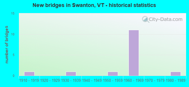
- New bridges - historical statistics
- 11910-1919
- 11930-1939
- 11950-1959
- 111960-1969
- 11980-1989
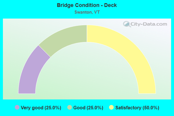
- Bridge Condition - Deck
- 25.0%Very good
- 25.0%Good
- 50.0%Satisfactory
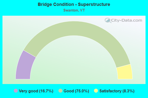
- Bridge Condition - Superstructure
- 16.7%Very good
- 75.0%Good
- 8.3%Satisfactory
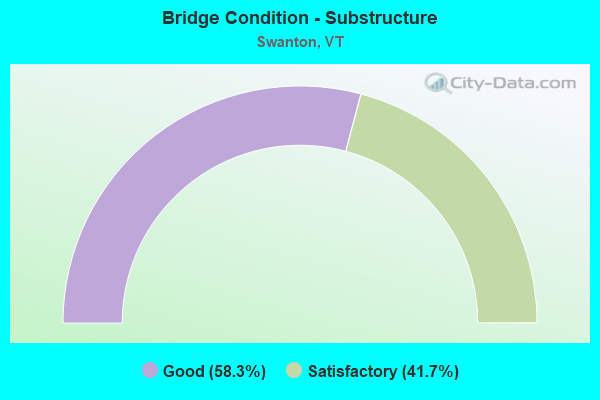
- Bridge Condition - Substructure
- 58.3%Good
- 41.7%Satisfactory
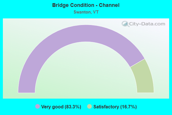
- Bridge Condition - Channel
- 83.3%Very good
- 16.7%Satisfactory
Find on map >> Show street view
Structure Number: 100615000406151, Location: 0.5 MI TO JCT W CL2 TH4 (Lat: 44.895425, Lng: -73.056719), Route carried "on" structure: Other road C2003, Year Built: 1957, Status: Open, Structure Length: 0.88m (2.89ft), Average Daily Traffic: 1,220 (year 2019), Truck Traffic: 3%, Average Future Daily Traffic: 1,281 (year 2029), Features Intersected: HUNGERFORD BROOK
Minimum Vertical Clearance: 30+ m (98+ ft), Kilometerpoint: 0.000, Lanes on structure: 2, Owner: Town or Township Highway Agency, Approaching Roadway Width: 7.0m (23.0ft), Material/Design: Steel, Design/Construction: Stringer/Multi-beam, Number Of Spans In Main Unit: 1, Length of Maximum Span: 8.2m (26.9ft), Curb-To-Curb Width: 7.6m (24.9ft), Out-to-Out Width: 7.9m (25.9ft)
Condition: Deck: Very good, Superstructure: Good, Substructure: Good, Channel: Satisfactory, Operating Rating: 27.2 metric tons, Method Used To Determine Operating Rating: Load Factor (LF), Inventory Rating: 16.3 metric tons, Method Used To Determine Inventory Rating: Load Factor (LF), Structural Evaluation: Meets minimum limits, Deck Geometry: Meets minimum limits, Waterway Adequacy: Equal to present minimum criteria, Approach Roadway Alignment: Equal to present desirable criteria, Length Of Structure Improvement: 0.88m (2.89ft), Designated Inspection Frequency: Every 24 months, Inspection Date: September 2021, Bridge Improvement Cost: $262,000, Roadway Improvement Cost: $50,000, Total Project Cost: $312,000 ( Estimate for 2020), Deck Structure Type: Concrete Cast-file-Place, Wearing Surface/Protective System: Wearing Surface: Bituminous
Find on map >> Show street view
Structure Number: 200036000107012, Location: 0.6 MI E JCT. U.S.2 (Lat: 44.966700, Lng: -73.269919), Route carried "on" structure: State highway 78, Year Built: 1938, Year Reconstructed: 1990, Status: Open, Structure Length: 1.80m (5.91ft), Average Daily Traffic: 5,300 (year 2018), Truck Traffic: 10%, Average Future Daily Traffic: 5,565 (year 2028), Design Load: HS 20, Features Intersected: MUD CREEK
Minimum Vertical Clearance: 30+ m (98+ ft), Kilometerpoint: 0.949, Lanes on structure: 2, Base Highway Network: Yes, Owner: State Highway Agency, Approaching Roadway Width: 8.5m (27.9ft), Skew: 3 degrees, Material/Design: Steel, Design/Construction: Stringer/Multi-beam, Number Of Spans In Main Unit: 1, Length of Maximum Span: 17.4m (57.1ft), Curb-To-Curb Width: 8.6m (28.2ft), Out-to-Out Width: 9.2m (30.2ft)
Condition: Deck: Very good, Superstructure: Good, Substructure: Good, Channel: Very good, Operating Rating: 51.7 metric tons, Method Used To Determine Operating Rating: Load Factor (LF), Inventory Rating: 30.8 metric tons, Method Used To Determine Inventory Rating: Load Factor (LF), Structural Evaluation: Better than present minimum criteria, Deck Geometry: High priority of replacement, Waterway Adequacy: Equal to present minimum criteria, Approach Roadway Alignment: Equal to present desirable criteria, Length Of Structure Improvement: 1.80m (5.91ft), Designated Inspection Frequency: Every 24 months, Inspection Date: July 2021, Bridge Improvement Cost: $626,000, Roadway Improvement Cost: $50,000, Total Project Cost: $676,000 ( Estimate for 2020), Deck Structure Type: Concrete Cast-file-Place, Wearing Surface/Protective System: Wearing Surface: Bituminous, Membrane: Preformed Fabric
Find on map >> Show street view
Structure Number: 200036000606152, Location: 0.2 MI W JCT. U.S.7 (Lat: 44.920853, Lng: -73.127519), Route carried "on" structure: State highway 78, Year Built: 1966, Status: Open, Structure Length: 9.20m (30.18ft), Average Daily Traffic: 10,800 (year 2018), Truck Traffic: 15%, Average Future Daily Traffic: 11,340 (year 2028), Design Load: HS 20, Features Intersected: MISSISQUOI RIVER
Minimum Vertical Clearance: 30+ m (98+ ft), Kilometerpoint: 15.976, Lanes on structure: 2, Base Highway Network: Yes (Inventory Route: 1100000, Subroute: 1), Owner: Town or Township Highway Agency, Approaching Roadway Width: 9.1m (29.9ft), Material/Design: Steel continuous, Design/Construction: Stringer/Multi-beam, Number Of Spans In Main Unit: 4, Length of Maximum Span: 24.4m (80.1ft), Curb or Sidewalk Widths: Left: 1.5m (4.9ft), Right: 1.5m (4.9ft), Curb-To-Curb Width: 12.2m (40.0ft), Out-to-Out Width: 12.7m (41.7ft)
Condition: Deck: Satisfactory, Superstructure: Satisfactory, Substructure: Satisfactory, Channel: Very good, Operating Rating: 49.9 metric tons, Method Used To Determine Operating Rating: Load Factor (LF), Inventory Rating: 29.9 metric tons, Method Used To Determine Inventory Rating: Load Factor (LF), Structural Evaluation: Equal to present minimum criteria, Deck Geometry: Somewhat better than minimum adequacy, Waterway Adequacy: Equal to present desirable criteria, Approach Roadway Alignment: Equal to present desirable criteria, Length Of Structure Improvement: 9.20m (30.18ft), Designated Inspection Frequency: Every 24 months, Inspection Date: July 2021, Bridge Improvement Cost: $4,397,000, Roadway Improvement Cost: $50,000, Total Project Cost: $4,447,000 ( Estimate for 2020), Deck Structure Type: Concrete Cast-file-Place, Wearing Surface/Protective System: Wearing Surface: Bituminous, Membrane: Preformed Fabric
Find on map >> Show street view
Structure Number: 200089094N06152, Location: 3.1 MI S EXIT 21 (Lat: 44.895617, Lng: -73.090106), Route carried "on" structure: Interstate 89, Year Built: 1967, Status: Open, Structure Length: 3.23m (10.60ft), Average Daily Traffic: 10,700 (year 2018), Truck Traffic: 13%, Average Future Daily Traffic: 11,235 (year 2028), Design Load: HS 20, Features Intersected: I 89 OVER TH NO 3
Minimum Vertical Clearance: 30+ m (98+ ft), Kilometerpoint: 195.236, Lanes on structure: 2, Lanes under structure: 2, Base Highway Network: Yes, Owner: State Highway Agency, Approaching Roadway Width: 11.6m (38.1ft), Skew: 10 degrees, Material/Design: Steel, Design/Construction: Stringer/Multi-beam, Number Of Spans In Main Unit: 1, Length of Maximum Span: 30.5m (100.1ft), Curb or Sidewalk Widths: Left: 0.5m (1.6ft), Right: 0.5m (1.6ft), Curb-To-Curb Width: 11.6m (38.1ft), Out-to-Out Width: 13.3m (43.6ft)
Condition: Deck: Good, Superstructure: Very good, Substructure: Good, Operating Rating: 89.8 metric tons, Method Used To Determine Operating Rating: Load Factor (LF), Inventory Rating: 57.2 metric tons, Method Used To Determine Inventory Rating: Load Factor (LF), Structural Evaluation: Better than present minimum criteria, Deck Geometry: Equal to present minimum criteria, Underclear: Meets minimum limits, Approach Roadway Alignment: Equal to present desirable criteria, Designated Inspection Frequency: Every 24 months, Inspection Date: June 2020, Deck Structure Type: Concrete Cast-file-Place, Wearing Surface/Protective System: Wearing Surface: Bituminous, Membrane: Preformed Fabric
Find on map >> Show street view
Structure Number: 200089094S06152, Location: 3.1 MI S EXIT 21 (Lat: 44.895408, Lng: -73.090825), Route carried "on" structure: Interstate 89, Year Built: 1967, Status: Open, Structure Length: 3.54m (11.61ft), Average Daily Traffic: 10,700 (year 2018), Truck Traffic: 13%, Average Future Daily Traffic: 11,235 (year 2028), Design Load: HS 20, Features Intersected: I 89 OVER TH NO 3
Minimum Vertical Clearance: 30+ m (98+ ft), Kilometerpoint: 195.236, Lanes on structure: 2, Lanes under structure: 2, Base Highway Network: Yes, Owner: State Highway Agency, Approaching Roadway Width: 11.6m (38.1ft), Skew: 10 degrees, Material/Design: Steel, Design/Construction: Stringer/Multi-beam, Number Of Spans In Main Unit: 1, Length of Maximum Span: 33.5m (109.9ft), Curb or Sidewalk Widths: Left: 0.5m (1.6ft), Right: 0.5m (1.6ft), Curb-To-Curb Width: 11.6m (38.1ft), Out-to-Out Width: 13.3m (43.6ft)
Condition: Deck: Satisfactory, Superstructure: Good, Substructure: Good, Operating Rating: 89.8 metric tons, Method Used To Determine Operating Rating: Load Factor (LF), Inventory Rating: 58.1 metric tons, Method Used To Determine Inventory Rating: Load Factor (LF), Structural Evaluation: Better than present minimum criteria, Deck Geometry: Equal to present minimum criteria, Underclear: Better than present minimum criteria, Approach Roadway Alignment: Equal to present desirable criteria, Designated Inspection Frequency: Every 24 months, Inspection Date: June 2020, Deck Structure Type: Concrete Cast-file-Place, Wearing Surface/Protective System: Wearing Surface: Bituminous, Membrane: Other
Find on map >> Show street view
Structure Number: 200089096N06152, Location: 0.6 MI S EXIT 21 (Lat: 44.914428, Lng: -73.103358), Route carried "on" structure: Interstate 89, Year Built: 1964, Status: Open, Structure Length: 11.06m (36.29ft), Average Daily Traffic: 10,700 (year 2018), Truck Traffic: 13%, Average Future Daily Traffic: 11,235 (year 2028), Design Load: HS 20, Features Intersected: MISSISQUOI RIVER
Minimum Vertical Clearance: 30+ m (98+ ft), Kilometerpoint: 197.569, Lanes on structure: 2, Base Highway Network: Yes, Owner: State Highway Agency, Approaching Roadway Width: 11.0m (36.1ft), Skew: 11 degrees, Material/Design: Steel, Design/Construction: Stringer/Multi-beam, Number Of Spans In Main Unit: 3, Length of Maximum Span: 44.2m (145.0ft), Curb or Sidewalk Widths: Left: 0.2m (0.7ft), Right: 0.2m (0.7ft), Curb-To-Curb Width: 9.2m (30.2ft), Out-to-Out Width: 10.7m (35.1ft)
Condition: Deck: Satisfactory, Superstructure: Good, Substructure: Satisfactory, Channel: Very good, Operating Rating: 89.8 metric tons, Method Used To Determine Operating Rating: Load Factor (LF), Inventory Rating: 68.9 metric tons, Method Used To Determine Inventory Rating: Load Factor (LF), Structural Evaluation: Equal to present minimum criteria, Deck Geometry: Meets minimum limits, Waterway Adequacy: Equal to present desirable criteria, Approach Roadway Alignment: Equal to present desirable criteria, Length Of Structure Improvement: 11.06m (36.29ft), Designated Inspection Frequency: Every 24 months, Underwater Inspection Frequency: Every 48 months, Inspection Date: June 2020, Underwater Inspection Date: August 2018, Bridge Improvement Cost: $4,447,000, Roadway Improvement Cost: $50,000, Total Project Cost: $4,497,000 ( Estimate for 2020), Deck Structure Type: Concrete Cast-file-Place, Wearing Surface/Protective System: Wearing Surface: Bituminous
Find on map >> Show street view
Structure Number: 200089096S06152, Location: 0.6 MI S EXIT 21 (Lat: 44.914322, Lng: -73.103600), Route carried "on" structure: Interstate 89, Year Built: 1964, Status: Open, Structure Length: 11.06m (36.29ft), Average Daily Traffic: 10,700 (year 2018), Truck Traffic: 13%, Average Future Daily Traffic: 11,235 (year 2028), Design Load: HS 20, Features Intersected: MISSISQUOI RIVER
Minimum Vertical Clearance: 30+ m (98+ ft), Kilometerpoint: 197.569, Lanes on structure: 2, Base Highway Network: Yes, Owner: State Highway Agency, Approaching Roadway Width: 11.9m (39.0ft), Skew: 11 degrees, Material/Design: Steel, Design/Construction: Stringer/Multi-beam, Number Of Spans In Main Unit: 3, Length of Maximum Span: 44.2m (145.0ft), Curb or Sidewalk Widths: Left: 0.2m (0.7ft), Right: 0.2m (0.7ft), Curb-To-Curb Width: 9.2m (30.2ft), Out-to-Out Width: 10.7m (35.1ft)
Condition: Deck: Satisfactory, Superstructure: Good, Substructure: Satisfactory, Channel: Very good, Operating Rating: 89.8 metric tons, Method Used To Determine Operating Rating: Load Factor (LF), Inventory Rating: 68.9 metric tons, Method Used To Determine Inventory Rating: Load Factor (LF), Structural Evaluation: Equal to present minimum criteria, Deck Geometry: Meets minimum limits, Waterway Adequacy: Equal to present desirable criteria, Approach Roadway Alignment: Equal to present desirable criteria, Length Of Structure Improvement: 11.06m (36.29ft), Designated Inspection Frequency: Every 24 months, Underwater Inspection Frequency: Every 48 months, Inspection Date: June 2020, Underwater Inspection Date: August 2018, Bridge Improvement Cost: $4,447,000, Roadway Improvement Cost: $50,000, Total Project Cost: $4,497,000 ( Estimate for 2020), Deck Structure Type: Concrete Cast-file-Place, Wearing Surface/Protective System: Wearing Surface: Bituminous
Find on map >> Show street view
Structure Number: 200089097N06152, Location: 0.3 MI S EXIT 21 (Lat: 44.918867, Lng: -73.105692), Route carried "on" structure: Interstate 89, Year Built: 1964, Status: Open, Structure Length: 4.63m (15.19ft), Average Daily Traffic: 10,700 (year 2018), Truck Traffic: 13%, Average Future Daily Traffic: 11,235 (year 2028), Design Load: HS 20, Features Intersected: I 89 OVER BIKE PATH
Minimum Vertical Clearance: 30+ m (98+ ft), Kilometerpoint: 198.100, Lanes on structure: 2, Base Highway Network: Yes, Owner: State Highway Agency, Approaching Roadway Width: 11.6m (38.1ft), Skew: 10 degrees, Material/Design: Steel, Design/Construction: Stringer/Multi-beam, Number Of Spans In Main Unit: 3, Length of Maximum Span: 15.8m (51.8ft), Curb or Sidewalk Widths: Left: 0.2m (0.7ft), Right: 0.2m (0.7ft), Curb-To-Curb Width: 9.1m (29.9ft), Out-to-Out Width: 10.7m (35.1ft)
Condition: Deck: Satisfactory, Superstructure: Good, Substructure: Satisfactory, Operating Rating: 88.9 metric tons, Method Used To Determine Operating Rating: Load Factor (LF), Inventory Rating: 53.5 metric tons, Method Used To Determine Inventory Rating: Load Factor (LF), Structural Evaluation: Equal to present minimum criteria, Deck Geometry: High priority of replacement, Underclear: Somewhat better than minimum adequacy, Approach Roadway Alignment: Equal to present desirable criteria, Length Of Structure Improvement: 4.63m (15.19ft), Designated Inspection Frequency: Every 24 months, Inspection Date: June 2020, Bridge Improvement Cost: $1,862,000, Roadway Improvement Cost: $50,000, Total Project Cost: $1,912,000 ( Estimate for 2020), Deck Structure Type: Concrete Cast-file-Place, Wearing Surface/Protective System: Wearing Surface: Bituminous, Membrane: Preformed Fabric
Find on map >> Show street view
Structure Number: 200089097S06152, Location: 0.3 MI S EXIT 21 (Lat: 44.918800, Lng: -73.105994), Route carried "on" structure: Interstate 89, Year Built: 1964, Status: Open, Structure Length: 4.63m (15.19ft), Average Daily Traffic: 10,700 (year 2018), Truck Traffic: 13%, Average Future Daily Traffic: 11,235 (year 2028), Design Load: HS 20, Features Intersected: I 89 OVER BIKE PATH
Minimum Vertical Clearance: 30+ m (98+ ft), Kilometerpoint: 198.100, Lanes on structure: 3, Base Highway Network: Yes, Owner: State Highway Agency, Approaching Roadway Width: 14.6m (47.9ft), Skew: 10 degrees, Material/Design: Steel, Design/Construction: Stringer/Multi-beam, Number Of Spans In Main Unit: 3, Length of Maximum Span: 15.8m (51.8ft), Curb or Sidewalk Widths: Left: 0.2m (0.7ft), Right: 0.2m (0.7ft), Curb-To-Curb Width: 12.8m (42.0ft), Out-to-Out Width: 14.3m (46.9ft)
Condition: Deck: Good, Superstructure: Good, Substructure: Satisfactory, Operating Rating: 89.8 metric tons, Method Used To Determine Operating Rating: Load Factor (LF), Inventory Rating: 58.1 metric tons, Method Used To Determine Inventory Rating: Load Factor (LF), Structural Evaluation: Equal to present minimum criteria, Deck Geometry: High priority of replacement, Underclear: Somewhat better than minimum adequacy, Approach Roadway Alignment: Equal to present desirable criteria, Length Of Structure Improvement: 4.63m (15.19ft), Designated Inspection Frequency: Every 24 months, Inspection Date: June 2020, Bridge Improvement Cost: $2,500,000, Roadway Improvement Cost: $50,000, Total Project Cost: $2,550,000 ( Estimate for 2020), Deck Structure Type: Concrete Cast-file-Place, Wearing Surface/Protective System: Wearing Surface: Bituminous, Membrane: Preformed Fabric
Find on map >> Show street view
Structure Number: 200089098N06152, Location: I 89 EXIT 21 (Lat: 44.922267, Lng: -73.107444), Route carried "on" structure: Interstate 89, Year Built: 1964, Status: Open, Structure Length: 4.94m (16.21ft), Average Daily Traffic: 10,700 (year 2018), Truck Traffic: 13%, Average Future Daily Traffic: 11,235 (year 2028), Design Load: HS 20, Features Intersected: I 89 OVER VT 78
Minimum Vertical Clearance: 30+ m (98+ ft), Kilometerpoint: 198.502, Lanes on structure: 2, Lanes under structure: 2, Base Highway Network: Yes, Owner: State Highway Agency, Approaching Roadway Width: 11.6m (38.1ft), Skew: 10 degrees, Material/Design: Steel, Design/Construction: Stringer/Multi-beam, Number Of Spans In Main Unit: 3, Length of Maximum Span: 21.9m (71.9ft), Curb or Sidewalk Widths: Left: 0.2m (0.7ft), Right: 0.2m (0.7ft), Curb-To-Curb Width: 9.1m (29.9ft), Out-to-Out Width: 10.7m (35.1ft)
Condition: Deck: Satisfactory, Superstructure: Good, Substructure: Good, Operating Rating: 70.8 metric tons, Method Used To Determine Operating Rating: Load Factor (LF), Inventory Rating: 41.7 metric tons, Method Used To Determine Inventory Rating: Load Factor (LF), Structural Evaluation: Better than present minimum criteria, Deck Geometry: High priority of replacement, Underclear: Better than present minimum criteria, Approach Roadway Alignment: Equal to present desirable criteria, Length Of Structure Improvement: 4.94m (16.21ft), Designated Inspection Frequency: Every 24 months, Inspection Date: June 2020, Bridge Improvement Cost: $1,984,000, Roadway Improvement Cost: $50,000, Total Project Cost: $2,035,000 ( Estimate for 2020), Deck Structure Type: Concrete Cast-file-Place, Wearing Surface/Protective System: Wearing Surface: Bituminous, Membrane: Preformed Fabric
Find on map >> Show street view
Structure Number: 200089098S06152, Location: I 89 EXIT 21 (Lat: 44.922206, Lng: -73.107706), Route carried "on" structure: Interstate 89, Year Built: 1964, Status: Open, Structure Length: 4.94m (16.21ft), Average Daily Traffic: 10,700 (year 2018), Truck Traffic: 13%, Average Future Daily Traffic: 11,235 (year 2028), Design Load: HS 20, Features Intersected: I 89 OVER VT 78
Minimum Vertical Clearance: 30+ m (98+ ft), Kilometerpoint: 198.502, Lanes on structure: 2, Lanes under structure: 2, Base Highway Network: Yes, Owner: State Highway Agency, Approaching Roadway Width: 11.6m (38.1ft), Skew: 10 degrees, Material/Design: Steel, Design/Construction: Stringer/Multi-beam, Number Of Spans In Main Unit: 3, Length of Maximum Span: 21.9m (71.9ft), Curb or Sidewalk Widths: Left: 0.2m (0.7ft), Right: 0.2m (0.7ft), Curb-To-Curb Width: 9.1m (29.9ft), Out-to-Out Width: 10.7m (35.1ft)
Condition: Deck: Good, Superstructure: Good, Substructure: Good, Operating Rating: 70.8 metric tons, Method Used To Determine Operating Rating: Load Factor (LF), Inventory Rating: 41.7 metric tons, Method Used To Determine Inventory Rating: Load Factor (LF), Structural Evaluation: Better than present minimum criteria, Deck Geometry: High priority of replacement, Underclear: Better than present minimum criteria, Approach Roadway Alignment: Equal to present desirable criteria, Length Of Structure Improvement: 4.94m (16.21ft), Designated Inspection Frequency: Every 24 months, Inspection Date: June 2020, Bridge Improvement Cost: $1,984,000, Roadway Improvement Cost: $50,000, Total Project Cost: $2,035,000 ( Estimate for 2020), Deck Structure Type: Concrete Cast-file-Place, Wearing Surface/Protective System: Wearing Surface: Bituminous, Membrane: Other
Find on map >> Show street view
Structure Number: 200285017806152, Location: 1.0 MI S JCT. VT.78 E (Lat: 44.910242, Lng: -73.106697), Route carried "on" structure: US 7, Year Built: 1984, Status: Open, Structure Length: 9.48m (31.10ft), Average Daily Traffic: 3,800 (year 2018), Truck Traffic: 6%, Average Future Daily Traffic: 3,990 (year 2028), Design Load: HS 25 or greater, Features Intersected: MISSISQUOI RIVER
Minimum Vertical Clearance: 30+ m (98+ ft), Kilometerpoint: 0.000, Lanes on structure: 2, Owner: State Highway Agency, Approaching Roadway Width: 11.6m (38.1ft), Material/Design: Steel continuous, Design/Construction: Stringer/Multi-beam, Number Of Spans In Main Unit: 2, Length of Maximum Span: 46.9m (153.9ft), Curb-To-Curb Width: 11.8m (38.7ft), Out-to-Out Width: 13.0m (42.7ft)
Condition: Deck: Very good, Superstructure: Very good, Substructure: Good, Channel: Very good, Operating Rating: 86.2 metric tons, Method Used To Determine Operating Rating: Allowable Stress (AS), Inventory Rating: 49.0 metric tons, Method Used To Determine Inventory Rating: Allowable Stress (AS), Structural Evaluation: Better than present minimum criteria, Deck Geometry: Somewhat better than minimum adequacy, Waterway Adequacy: Equal to present desirable criteria, Approach Roadway Alignment: Equal to present desirable criteria, Designated Inspection Frequency: Every 24 months, Underwater Inspection Frequency: Every 48 months, Inspection Date: July 2021, Underwater Inspection Date: August 2018, Deck Structure Type: Concrete Cast-file-Place, Wearing Surface/Protective System: Wearing Surface: Bituminous, Membrane: Preformed Fabric, Deck Protection: Epoxy Coated Reinforcing
Find on map >> Show street view
Structure Number: 100615001806151, Location: 0.1 MI TO JCT W US7 (Lat: 44.874097, Lng: -73.099986), Route carried "under" structure: Other road C3032, Year Built: 1919, Structure Length: 0. m, Average Daily Traffic: 20 (year 1999), Truck Traffic: 2%, Features Intersected: NEW ENGLAND CENTRAL RR, Facility Carried by Structure: RAILROAD
Kilometerpoint: 0.000, Material/Design: Steel, Design/Construction: Stringer/Multi-beam, Length of Maximum Span: 7.6m (24.9ft)
Find on map >> Show street view
Structure Number: 200089098N06152, Location: I 89 EXIT 21 (Lat: 44.922267, Lng: -73.107444), Route carried "under" structure: State highway 78, Year Built: 1964, Structure Length: 0. m, Average Daily Traffic: 8,500 (year 1996), Truck Traffic: 10%, Features Intersected: I 89 OVER VT 78, Facility Carried by Structure: I 00089 ML
Minimum Vertical Clearance: 5.00m (16.40ft), Kilometerpoint: 0.000, Lanes on structure: 2, Material/Design: Steel, Design/Construction: Stringer/Multi-beam, Length of Maximum Span: 21.9m (71.9ft)
Find on map >> Show street view
Structure Number: 200089098S06152, Location: I 89 EXIT 21 (Lat: 44.922206, Lng: -73.107706), Route carried "under" structure: State highway 78, Year Built: 1964, Structure Length: 0. m, Average Daily Traffic: 8,500 (year 1996), Truck Traffic: 10%, Features Intersected: I 89 OVER VT 78, Facility Carried by Structure: I 00089 ML
Minimum Vertical Clearance: 5.00m (16.40ft), Kilometerpoint: 17.633, Lanes on structure: 2, Material/Design: Steel, Design/Construction: Stringer/Multi-beam, Length of Maximum Span: 21.9m (71.9ft)