Bridge Statistics for Swartz Creek, Michigan (MI)
Condition, Traffic, Stress, Structural Evaluation, Project Costs
- National Bridge Inventory (NBI) Statistics
- 27Number of bridges
- 266ft / 81.3mTotal length
- $88,000Total costs
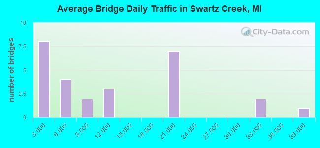
- 305,200Total average daily traffic
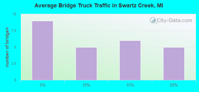
- 38,460Total average daily truck traffic
- National Bridge Inventory (NBI) Registered Bridges for Swartz Creek
- No street view available for this location
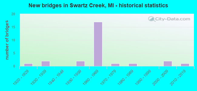
- New bridges - historical statistics
- 11920-1929
- 21930-1939
- 21950-1959
- 171960-1969
- 11970-1979
- 11980-1989
- 22000-2009
- 12010-2019
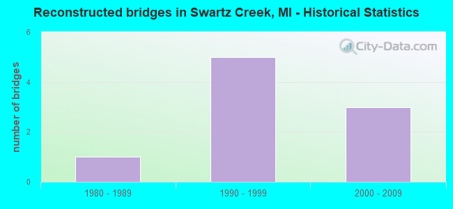
- Reconstructed bridges - Historical Statistics
- 11980-1989
- 51990-1999
- 32000-2009
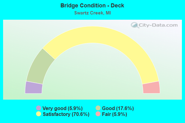
- Bridge Condition - Deck
- 5.9%Very good
- 17.6%Good
- 70.6%Satisfactory
- 5.9%Fair
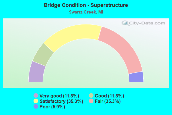
- Bridge Condition - Superstructure
- 11.8%Very good
- 11.8%Good
- 35.3%Satisfactory
- 35.3%Fair
- 5.9%Poor
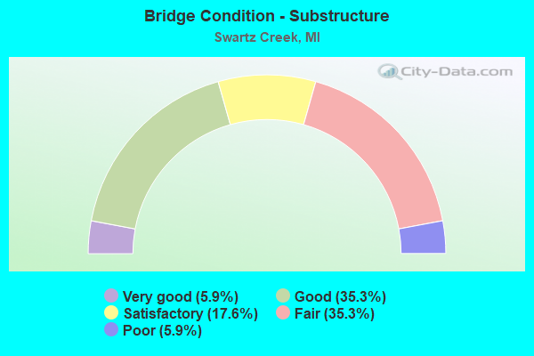
- Bridge Condition - Substructure
- 5.9%Very good
- 35.3%Good
- 17.6%Satisfactory
- 35.3%Fair
- 5.9%Poor
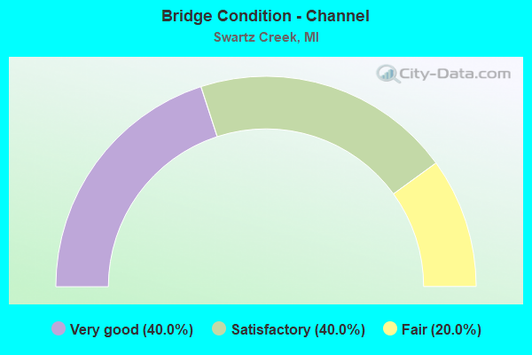
- Bridge Condition - Channel
- 40.0%Very good
- 40.0%Satisfactory
- 20.0%Fair
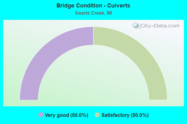
- Bridge Condition - Culverts
- 50.0%Very good
- 50.0%Satisfactory
Find on map >> Show street view
Structure Number: 287, Location: APPROX 1/4MI W OF 43RD ST (Lat: 42.761125, Lng: -85.974417), Route carried "on" structure: County highway , Year Built: 1987, Status: Open, Structure Length: 0.84m (2.76ft), Average Daily Traffic: 600 (year 2002), Truck Traffic: 7%, Average Future Daily Traffic: 1,200 (year 2022), Design Load: H 20, Features Intersected: OVER A SMALL CREEK, Facility Carried by Structure: 147TH AVE
Minimum Vertical Clearance: 30.48m (100.00ft), Kilometerpoint: 0.874, Lanes on structure: 2, Owner: County Highway Agency, Approaching Roadway Width: 8.8m (28.9ft), Skew: 2 degrees, Material/Design: Steel, Design/Construction: Culvert, Number Of Spans In Main Unit: 2, Length of Maximum Span: 3.4m (11.2ft)
Condition: Channel: Satisfactory, Culverts: Satisfactory, Operating Rating: 52.5 metric tons, Method Used To Determine Operating Rating: Load Factor (LF) rating reported by rating factor (RF) method using MS18 loading, Inventory Rating: 31.4 metric tons, Method Used To Determine Inventory Rating: Load Factor (LF) rating reported by rating factor (RF) method using MS18 loading, Structural Evaluation: Equal to present minimum criteria, Waterway Adequacy: Equal to present minimum criteria, Approach Roadway Alignment: Equal to present desirable criteria, Designated Inspection Frequency: Every 24 months, Inspection Date: May 2021
Find on map >> Show street view
Structure Number: 2526, Location: E OF MILLER @ SWARTZ CRK (Lat: 42.964500, Lng: -83.801514), Route carried "on" structure: Interstate 69, Year Built: 1968, Status: Open, Structure Length: 8.67m (28.44ft), Average Daily Traffic: 19,829 (year 2007), Truck Traffic: 14%, Average Future Daily Traffic: 24,684 (year 2018), Design Load: HS 20, Features Intersected: GTW RR & SWARTZ CREEK
Minimum Vertical Clearance: 30.48m (100.00ft), Kilometerpoint: 10.413, Lanes on structure: 3, Base Highway Network: Yes (Inventory Route: 149, Subroute: 5), Owner: State Highway Agency, Approaching Roadway Width: 15.9m (52.2ft), Skew: 3 degrees, Material/Design: Steel, Design/Construction: Stringer/Multi-beam, Number Of Spans In Main Unit: 4, Length of Maximum Span: 26.2m (86.0ft), Curb-To-Curb Width: 12.8m (42.0ft), Out-to-Out Width: 14.0m (45.9ft)
Condition: Deck: Satisfactory, Superstructure: Fair, Substructure: Fair, Channel: Very good, Operating Rating: 63.5 metric tons, Method Used To Determine Operating Rating: Load Factor (LF) rating reported by rating factor (RF) method using MS18 loading, Inventory Rating: 38.2 metric tons, Method Used To Determine Inventory Rating: Load Factor (LF) rating reported by rating factor (RF) method using MS18 loading, Structural Evaluation: Somewhat better than minimum adequacy, Deck Geometry: Meets minimum limits, Underclear: Superior to present desirable criteria, Waterway Adequacy: Equal to present desirable criteria, Approach Roadway Alignment: Equal to present desirable criteria, Designated Inspection Frequency: Every 24 months, Inspection Date: November 2021, Deck Structure Type: Concrete Cast-file-Place, Wearing Surface/Protective System: Wearing Surface: Epoxy Overlay
Find on map >> Show street view
Structure Number: 2527, Location: E OF MILLER RD & R04 (Lat: 42.964494, Lng: -83.795342), Route carried "on" structure: Interstate 69, Year Built: 1968, Year Reconstructed: 1998, Status: Open, Structure Length: 6.18m (20.28ft), Average Daily Traffic: 19,829 (year 2007), Truck Traffic: 14%, Average Future Daily Traffic: 24,684 (year 2018), Design Load: HS 20, Features Intersected: GTW RR
Minimum Vertical Clearance: 30.48m (100.00ft), Kilometerpoint: 10.925, Lanes on structure: 2, Base Highway Network: Yes (Inventory Route: 149, Subroute: 5), Owner: State Highway Agency, Approaching Roadway Width: 12.2m (40.0ft), Skew: 4 degrees, Material/Design: Steel, Design/Construction: Stringer/Multi-beam, Number Of Spans In Main Unit: 3, Length of Maximum Span: 21.6m (70.9ft), Curb-To-Curb Width: 12.2m (40.0ft), Out-to-Out Width: 12.9m (42.3ft)
Condition: Deck: Satisfactory, Superstructure: Fair, Substructure: Good, Operating Rating: 64.2 metric tons, Method Used To Determine Operating Rating: Load Factor (LF) rating reported by rating factor (RF) method using MS18 loading, Inventory Rating: 38.6 metric tons, Method Used To Determine Inventory Rating: Load Factor (LF) rating reported by rating factor (RF) method using MS18 loading, Structural Evaluation: Somewhat better than minimum adequacy, Deck Geometry: Better than present minimum criteria, Approach Roadway Alignment: Equal to present desirable criteria, Designated Inspection Frequency: Every 24 months, Inspection Date: August 2021, Deck Structure Type: Concrete Cast-file-Place, Wearing Surface/Protective System: Wearing Surface: Epoxy Overlay
Find on map >> Show street view
Structure Number: 2528, Location: E OF MILLER @ SWARTZ CRK (Lat: 42.964719, Lng: -83.801206), Route carried "on" structure: Interstate 69, Year Built: 1968, Year Reconstructed: 1998, Status: Open, Structure Length: 8.67m (28.44ft), Average Daily Traffic: 19,829 (year 2007), Truck Traffic: 14%, Average Future Daily Traffic: 24,684 (year 2018), Design Load: HS 20, Features Intersected: GTW RR &SWARTZ CREEK
Minimum Vertical Clearance: 30.48m (100.00ft), Kilometerpoint: 10.439, Lanes on structure: 2, Base Highway Network: Yes (Inventory Route: 149, Subroute: 6), Owner: State Highway Agency, Approaching Roadway Width: 12.8m (42.0ft), Skew: 3 degrees, Material/Design: Steel, Design/Construction: Stringer/Multi-beam, Number Of Spans In Main Unit: 4, Length of Maximum Span: 26.1m (85.6ft), Curb or Sidewalk Widths: Left: 0.2m (0.7ft), Right: 0.6m (2.0ft), Curb-To-Curb Width: 9.4m (30.8ft), Out-to-Out Width: 10.7m (35.1ft)
Condition: Deck: Satisfactory, Superstructure: Fair, Substructure: Fair, Channel: Very good, Operating Rating: 77.4 metric tons, Method Used To Determine Operating Rating: Load Factor (LF) rating reported by rating factor (RF) method using MS18 loading, Inventory Rating: 46.3 metric tons, Method Used To Determine Inventory Rating: Load Factor (LF) rating reported by rating factor (RF) method using MS18 loading, Structural Evaluation: Somewhat better than minimum adequacy, Deck Geometry: Meets minimum limits, Underclear: Superior to present desirable criteria, Waterway Adequacy: Equal to present desirable criteria, Approach Roadway Alignment: Equal to present desirable criteria, Designated Inspection Frequency: Every 24 months, Inspection Date: November 2021, Deck Structure Type: Concrete Cast-file-Place, Wearing Surface/Protective System: Wearing Surface: Epoxy Overlay
Find on map >> Show street view
Structure Number: 2533, Location: 2.0 MI E OF M-13 (Lat: 42.964600, Lng: -83.889872), Route carried "on" structure: County highway , Year Built: 1959, Status: Open, Structure Length: 6.89m (22.60ft), Average Daily Traffic: 500 (year 1996), Truck Traffic: 2%, Average Future Daily Traffic: 900 (year 2016), Design Load: H 15, Features Intersected: I-69, Facility Carried by Structure: NICHOLS RD
Minimum Vertical Clearance: 30.48m (100.00ft), Kilometerpoint: 0.838, Lanes on structure: 2, Lanes under structure: 4, Owner: State Highway Agency, Approaching Roadway Width: 11.8m (38.7ft), Material/Design: Concrete continuous, Design/Construction: Tee Beam, Number Of Spans In Main Unit: 4, Length of Maximum Span: 21.6m (70.9ft), Curb-To-Curb Width: 8.5m (27.9ft), Out-to-Out Width: 9.6m (31.5ft)
Condition: Deck: Satisfactory, Superstructure: Satisfactory, Substructure: Good, Operating Rating: 46.3 metric tons, Method Used To Determine Operating Rating: Load Factor (LF) rating reported by rating factor (RF) method using MS18 loading, Inventory Rating: 27.9 metric tons, Method Used To Determine Inventory Rating: Load Factor (LF) rating reported by rating factor (RF) method using MS18 loading, Structural Evaluation: Equal to present minimum criteria, Deck Geometry: Somewhat better than minimum adequacy, Underclear: Meets minimum limits, Approach Roadway Alignment: Equal to present desirable criteria, Designated Inspection Frequency: Every 24 months, Inspection Date: July 2020, Deck Structure Type: Concrete Cast-file-Place, Wearing Surface/Protective System: Wearing Surface: Epoxy Overlay
Find on map >> Show street view
Structure Number: 2534, Location: 1.5 MI NW OF SWARTZ CREEK (Lat: 42.964628, Lng: -83.850592), Route carried "on" structure: County highway 2002, Year Built: 1960, Status: Open, Structure Length: 6.89m (22.60ft), Average Daily Traffic: 3,600 (year 1996), Truck Traffic: 3%, Average Future Daily Traffic: 6,500 (year 2016), Design Load: H 15, Features Intersected: I-69, Facility Carried by Structure: SEYMOUR RD
Minimum Vertical Clearance: 30.48m (100.00ft), Kilometerpoint: 0.855, Lanes on structure: 2, Lanes under structure: 4, Owner: State Highway Agency, Approaching Roadway Width: 11.8m (38.7ft), Material/Design: Concrete continuous, Design/Construction: Tee Beam, Number Of Spans In Main Unit: 4, Length of Maximum Span: 21.6m (70.9ft), Curb-To-Curb Width: 9.1m (29.9ft), Out-to-Out Width: 10.2m (33.5ft)
Condition: Deck: Satisfactory, Superstructure: Satisfactory, Substructure: Good, Operating Rating: 49.9 metric tons, Method Used To Determine Operating Rating: Load Factor (LF) rating reported by rating factor (RF) method using MS18 loading, Inventory Rating: 29.8 metric tons, Method Used To Determine Inventory Rating: Load Factor (LF) rating reported by rating factor (RF) method using MS18 loading, Structural Evaluation: Equal to present minimum criteria, Deck Geometry: Meets minimum limits, Underclear: High priority of corrective action, Approach Roadway Alignment: Equal to present desirable criteria, Designated Inspection Frequency: Every 24 months, Inspection Date: July 2020, Bridge Improvement Cost: $27,000, Deck Structure Type: Concrete Cast-file-Place, Wearing Surface/Protective System: Wearing Surface: Epoxy Overlay
Find on map >> Show street view
Structure Number: 2535, Location: 0.5 MI N OF SWARTZ CREEK (Lat: 42.965217, Lng: -83.830753), Route carried "on" structure: City street 2002, Year Built: 1960, Status: Open, Structure Length: 6.89m (22.60ft), Average Daily Traffic: 6,737 (year 1997), Truck Traffic: 7%, Average Future Daily Traffic: 12,194 (year 2017), Design Load: H 15, Features Intersected: I-69, Facility Carried by Structure: MORRISH RD
Minimum Vertical Clearance: 30.48m (100.00ft), Kilometerpoint: 1.054, Lanes on structure: 2, Lanes under structure: 4, Owner: State Highway Agency, Approaching Roadway Width: 12.2m (40.0ft), Material/Design: Concrete continuous, Design/Construction: Tee Beam, Number Of Spans In Main Unit: 4, Length of Maximum Span: 21.6m (70.9ft), Curb-To-Curb Width: 9.1m (29.9ft), Out-to-Out Width: 10.2m (33.5ft)
Condition: Deck: Fair, Superstructure: Fair, Substructure: Fair, Operating Rating: 49.6 metric tons, Method Used To Determine Operating Rating: Load Factor (LF) rating reported by rating factor (RF) method using MS18 loading, Inventory Rating: 29.8 metric tons, Method Used To Determine Inventory Rating: Load Factor (LF) rating reported by rating factor (RF) method using MS18 loading, Structural Evaluation: Somewhat better than minimum adequacy, Deck Geometry: Meets minimum limits, Underclear: High priority of corrective action, Approach Roadway Alignment: Equal to present desirable criteria, Designated Inspection Frequency: Every 24 months, Inspection Date: July 2020, Deck Structure Type: Concrete Cast-file-Place, Wearing Surface/Protective System: Wearing Surface: Epoxy Overlay
Find on map >> Show street view
Structure Number: 2536, Location: 1.2 MI NE OF SWARTZ CREEK (Lat: 42.965908, Lng: -83.811328), Route carried "on" structure: Interstate 69, Year Built: 1960, Year Reconstructed: 1995, Status: Open, Structure Length: 4.17m (13.68ft), Average Daily Traffic: 18,639 (year 2007), Truck Traffic: 15%, Average Future Daily Traffic: 22,808 (year 2018), Design Load: HS 20, Features Intersected: ELMS RD
Minimum Vertical Clearance: 30+ m (98+ ft), Kilometerpoint: 9.590, Lanes on structure: 2, Lanes under structure: 2, Base Highway Network: Yes (Inventory Route: 149, Subroute: 5), Owner: State Highway Agency, Approaching Roadway Width: 13.4m (44.0ft), Skew: 10 degrees, Material/Design: Concrete continuous, Design/Construction: Tee Beam, Number Of Spans In Main Unit: 3, Length of Maximum Span: 19.2m (63.0ft), Curb-To-Curb Width: 12.8m (42.0ft), Out-to-Out Width: 14.4m (47.2ft)
Condition: Deck: Satisfactory, Superstructure: Satisfactory, Substructure: Satisfactory, Operating Rating: 55.4 metric tons, Method Used To Determine Operating Rating: Load Factor (LF) rating reported by rating factor (RF) method using MS18 loading, Inventory Rating: 33.4 metric tons, Method Used To Determine Inventory Rating: Load Factor (LF) rating reported by rating factor (RF) method using MS18 loading, Structural Evaluation: Equal to present minimum criteria, Deck Geometry: Equal to present desirable criteria, Underclear: Somewhat better than minimum adequacy, Approach Roadway Alignment: Equal to present desirable criteria, Designated Inspection Frequency: Every 24 months, Inspection Date: July 2020, Deck Structure Type: Concrete Cast-file-Place, Wearing Surface/Protective System: Wearing Surface: Epoxy Overlay
Find on map >> Show street view
Structure Number: 2537, Location: 1.2 MI NE OF SWARTZ CREEK (Lat: 42.966175, Lng: -83.811328), Route carried "on" structure: Interstate 69, Year Built: 1960, Year Reconstructed: 1995, Status: Open, Structure Length: 4.17m (13.68ft), Average Daily Traffic: 18,639 (year 2007), Truck Traffic: 15%, Average Future Daily Traffic: 22,808 (year 2018), Design Load: HS 20, Features Intersected: ELMS RD
Minimum Vertical Clearance: 30+ m (98+ ft), Kilometerpoint: 9.590, Lanes on structure: 3, Lanes under structure: 2, Base Highway Network: Yes (Inventory Route: 149, Subroute: 6), Owner: State Highway Agency, Approaching Roadway Width: 16.4m (53.8ft), Skew: 10 degrees, Material/Design: Concrete continuous, Design/Construction: Tee Beam, Number Of Spans In Main Unit: 3, Length of Maximum Span: 19.2m (63.0ft), Curb-To-Curb Width: 15.8m (51.8ft), Out-to-Out Width: 17.5m (57.4ft)
Condition: Deck: Satisfactory, Superstructure: Satisfactory, Substructure: Satisfactory, Operating Rating: 58.6 metric tons, Method Used To Determine Operating Rating: Load Factor (LF) rating reported by rating factor (RF) method using MS18 loading, Inventory Rating: 35.0 metric tons, Method Used To Determine Inventory Rating: Load Factor (LF) rating reported by rating factor (RF) method using MS18 loading, Structural Evaluation: Equal to present minimum criteria, Deck Geometry: Somewhat better than minimum adequacy, Underclear: High priority of corrective action, Approach Roadway Alignment: Equal to present desirable criteria, Designated Inspection Frequency: Every 24 months, Inspection Date: July 2020, Deck Structure Type: Concrete Cast-file-Place, Wearing Surface/Protective System: Wearing Surface: Epoxy Overlay
Find on map >> Show street view
Structure Number: 2552, Location: IN SWARTZ CREEK (Lat: 42.965853, Lng: -83.808161), Route carried "on" structure: Interstate 69, Year Built: 1968, Year Reconstructed: 2006, Status: Open, Structure Length: 7.11m (23.33ft), Average Daily Traffic: 19,829 (year 2007), Truck Traffic: 14%, Average Future Daily Traffic: 24,684 (year 2018), Design Load: HS 20, Features Intersected: MILLER RD
Minimum Vertical Clearance: 30.48m (100.00ft), Kilometerpoint: 9.850, Lanes on structure: 3, Lanes under structure: 4, Base Highway Network: Yes (Inventory Route: 149, Subroute: 5), Owner: State Highway Agency, Approaching Roadway Width: 15.8m (51.8ft), Skew: 4 degrees, Material/Design: Steel, Design/Construction: Stringer/Multi-beam, Number Of Spans In Main Unit: 4, Length of Maximum Span: 20.3m (66.6ft), Curb-To-Curb Width: 13.6m (44.6ft), Out-to-Out Width: 14.5m (47.6ft)
Condition: Deck: Satisfactory, Superstructure: Fair, Substructure: Satisfactory, Operating Rating: 68.0 metric tons, Method Used To Determine Operating Rating: Load Factor (LF) rating reported by rating factor (RF) method using MS18 loading, Inventory Rating: 40.8 metric tons, Method Used To Determine Inventory Rating: Load Factor (LF) rating reported by rating factor (RF) method using MS18 loading, Structural Evaluation: Somewhat better than minimum adequacy, Deck Geometry: Meets minimum limits, Underclear: Somewhat better than minimum adequacy, Approach Roadway Alignment: Equal to present desirable criteria, Designated Inspection Frequency: Every 24 months, Inspection Date: July 2020, Bridge Improvement Cost: $251,000, Deck Structure Type: Concrete Cast-file-Place, Wearing Surface/Protective System: Wearing Surface: Latex Concrete
Find on map >> Show street view
Structure Number: 2554, Location: IN SWARTZ CREEK (Lat: 42.966075, Lng: -83.807647), Route carried "on" structure: Interstate 69, Year Built: 1968, Year Reconstructed: 2006, Status: Open, Structure Length: 6.82m (22.38ft), Average Daily Traffic: 19,829 (year 2007), Truck Traffic: 14%, Average Future Daily Traffic: 24,684 (year 2018), Design Load: HS 20, Features Intersected: MILLER RD
Minimum Vertical Clearance: 30.48m (100.00ft), Kilometerpoint: 9.891, Lanes on structure: 2, Lanes under structure: 4, Base Highway Network: Yes (Inventory Route: 149, Subroute: 6), Owner: State Highway Agency, Approaching Roadway Width: 12.2m (40.0ft), Skew: 14 degrees, Material/Design: Steel, Design/Construction: Stringer/Multi-beam, Number Of Spans In Main Unit: 4, Length of Maximum Span: 19.5m (64.0ft), Curb-To-Curb Width: 11.9m (39.0ft), Out-to-Out Width: 12.8m (42.0ft)
Condition: Deck: Good, Superstructure: Satisfactory, Substructure: Good, Operating Rating: 97.2 metric tons, Method Used To Determine Operating Rating: Load Factor (LF) rating reported by rating factor (RF) method using MS18 loading, Inventory Rating: 60.3 metric tons, Method Used To Determine Inventory Rating: Load Factor (LF) rating reported by rating factor (RF) method using MS18 loading, Structural Evaluation: Equal to present minimum criteria, Deck Geometry: Equal to present minimum criteria, Underclear: Somewhat better than minimum adequacy, Approach Roadway Alignment: Equal to present desirable criteria, Designated Inspection Frequency: Every 24 months, Other Special Inspection Frequency: Every 12 months, Inspection Date: July 2020, Other Special Inspection Date: July 2021, Bridge Improvement Cost: $200,000, Deck Structure Type: Concrete Cast-file-Place, Wearing Surface/Protective System: Wearing Surface: Latex Concrete
Find on map >> Show street view
Structure Number: 2555, Location: IN SWARTZ CREEK (Lat: 42.966186, Lng: -83.807361), Route carried "on" structure: Ramp Interstate 69, Year Built: 1968, Year Reconstructed: 1991, Status: Open, Structure Length: 5.94m (19.49ft), Average Daily Traffic: 7,200 (year 1988), Truck Traffic: 11%, Average Future Daily Traffic: 8,280 (year 2008), Design Load: HS 20, Features Intersected: MILLER RD
Minimum Vertical Clearance: 30.48m (100.00ft), Kilometerpoint: 0.224, Lanes on structure: 1, Lanes under structure: 4, Owner: State Highway Agency, Approaching Roadway Width: 9.7m (31.8ft), Skew: 4 degrees, Material/Design: Steel, Design/Construction: Stringer/Multi-beam, Number Of Spans In Main Unit: 4, Length of Maximum Span: 17.0m (55.8ft), Curb or Sidewalk Widths: Left: 0.2m (0.7ft), Right: 0.2m (0.7ft), Curb-To-Curb Width: 7.0m (23.0ft), Out-to-Out Width: 8.2m (26.9ft)
Condition: Deck: Satisfactory, Superstructure: Satisfactory, Substructure: Fair, Operating Rating: 95.3 metric tons, Method Used To Determine Operating Rating: Load Factor (LF) rating reported by rating factor (RF) method using MS18 loading, Inventory Rating: 57.0 metric tons, Method Used To Determine Inventory Rating: Load Factor (LF) rating reported by rating factor (RF) method using MS18 loading, Structural Evaluation: Somewhat better than minimum adequacy, Deck Geometry: Equal to present minimum criteria, Underclear: Somewhat better than minimum adequacy, Approach Roadway Alignment: Equal to present desirable criteria, Designated Inspection Frequency: Every 24 months, Other Special Inspection Frequency: Every 12 months, Inspection Date: July 2020, Other Special Inspection Date: July 2021, Bridge Improvement Cost: $200,000, Deck Structure Type: Concrete Cast-file-Place, Wearing Surface/Protective System: Wearing Surface: Latex Concrete
Find on map >> Show street view
Structure Number: 2736, Location: BET GRAND BLANC & REID RD (Lat: 42.920550, Lng: -83.830578), Route carried "on" structure: County highway , Year Built: 1928, Status: Open, Structure Length: 0.82m (2.69ft), Average Daily Traffic: 3,044 (year 2018), Truck Traffic: 5%, Average Future Daily Traffic: 5,498 (year 2038), Design Load: HS 20+Mod, Features Intersected: ALGER CREEK, Facility Carried by Structure: MORRISH ROAD
Minimum Vertical Clearance: 30.48m (100.00ft), Kilometerpoint: 4.865, Lanes on structure: 2, Owner: County Highway Agency, Approaching Roadway Width: 11.0m (36.1ft), Skew: 2 degrees, Material/Design: Concrete, Design/Construction: Tee Beam, Number Of Spans In Main Unit: 1, Length of Maximum Span: 7.0m (23.0ft), Curb-To-Curb Width: 11.0m (36.1ft), Out-to-Out Width: 11.7m (38.4ft)
Condition: Deck: Satisfactory, Superstructure: Poor, Substructure: Poor, Channel: Satisfactory, Operating Rating: 42.1 metric tons, Method Used To Determine Operating Rating: Load Factor (LF) rating reported by rating factor (RF) method using MS18 loading, Inventory Rating: 25.3 metric tons, Method Used To Determine Inventory Rating: Load Factor (LF) rating reported by rating factor (RF) method using MS18 loading, Structural Evaluation: Meets minimum limits, Deck Geometry: Somewhat better than minimum adequacy, Waterway Adequacy: Better than present minimum criteria, Approach Roadway Alignment: Equal to present desirable criteria, Length Of Structure Improvement: 0.91m (2.99ft), Designated Inspection Frequency: Every 12 months, Inspection Date: November 2021, Bridge Improvement Cost: $70,000, Roadway Improvement Cost: $7,000, Total Project Cost: $88,000, Deck Structure Type: Concrete Cast-file-Place, Wearing Surface/Protective System: Wearing Surface: Bituminous
Find on map >> Show street view
Structure Number: 2783, Location: BET I-69 & MILLER ROAD (Lat: 42.972261, Lng: -83.781839), Route carried "on" structure: County highway , Year Built: 1938, Year Reconstructed: 1996, Status: Open, Structure Length: 1.25m (4.10ft), Average Daily Traffic: 1,736 (year 2009), Truck Traffic: 5%, Average Future Daily Traffic: 3,135 (year 2029), Design Load: HS 20+Mod, Features Intersected: W.BR.SWARTZCREEK, Facility Carried by Structure: DYE ROAD
Minimum Vertical Clearance: 30.48m (100.00ft), Kilometerpoint: 0.460, Lanes on structure: 2, Owner: County Highway Agency, Approaching Roadway Width: 9.1m (29.9ft), Skew: 1 degrees, Material/Design: Prestressed concrete, Design/Construction: Box Beam or Girders - Multiple, Number Of Spans In Main Unit: 1, Length of Maximum Span: 11.8m (38.7ft), Curb-To-Curb Width: 9.1m (29.9ft), Out-to-Out Width: 10.1m (33.1ft)
Condition: Deck: Good, Superstructure: Good, Substructure: Fair, Channel: Satisfactory, Operating Rating: 91.0 metric tons, Method Used To Determine Operating Rating: Load Factor (LF) rating reported by rating factor (RF) method using MS18 loading, Inventory Rating: 54.4 metric tons, Method Used To Determine Inventory Rating: Load Factor (LF) rating reported by rating factor (RF) method using MS18 loading, Structural Evaluation: Somewhat better than minimum adequacy, Deck Geometry: Somewhat better than minimum adequacy, Waterway Adequacy: Equal to present desirable criteria, Approach Roadway Alignment: Equal to present desirable criteria, Designated Inspection Frequency: Every 24 months, Inspection Date: November 2020, Deck Structure Type: Concrete Cast-file-Place, Wearing Surface/Protective System: Wearing Surface: Monolithic Concrete
Find on map >> Show street view
Structure Number: 2792, Location: BET SEYMOUR & MORRISH RD (Lat: 42.927333, Lng: -83.834761), Route carried "on" structure: County highway , Year Built: 1930, Status: Posted for load, Structure Length: 0.82m (2.69ft), Average Daily Traffic: 216 (year 2009), Truck Traffic: 2%, Average Future Daily Traffic: 390 (year 2029), Design Load: HS 20+Mod, Features Intersected: ALGER CREEK, Facility Carried by Structure: REID ROAD
Minimum Vertical Clearance: 30.48m (100.00ft), Kilometerpoint: 7.738, Lanes on structure: 2, Owner: County Highway Agency, Approaching Roadway Width: 9.1m (29.9ft), Skew: 3 degrees, Material/Design: Concrete, Design/Construction: Tee Beam, Number Of Spans In Main Unit: 1, Length of Maximum Span: 7.6m (24.9ft), Curb-To-Curb Width: 9.1m (29.9ft), Out-to-Out Width: 9.8m (32.2ft)
Condition: Deck: Satisfactory, Superstructure: Fair, Substructure: Fair, Channel: Fair, Operating Rating: 33.4 metric tons, Method Used To Determine Operating Rating: Load Factor (LF) rating reported by rating factor (RF) method using MS18 loading, Inventory Rating: 20.1 metric tons, Method Used To Determine Inventory Rating: Load Factor (LF) rating reported by rating factor (RF) method using MS18 loading, Structural Evaluation: Somewhat better than minimum adequacy, Deck Geometry: Equal to present minimum criteria, Waterway Adequacy: Equal to present desirable criteria, Approach Roadway Alignment: Equal to present desirable criteria, Bridge Posting: Required (Relationship of Operating Rating to Maximum Legal Load: 10.0 - 19.9% below), Designated Inspection Frequency: Every 24 months, Inspection Date: November 2020, Deck Structure Type: Concrete Cast-file-Place, Wearing Surface/Protective System: Wearing Surface: Monolithic Concrete
Find on map >> Show street view
Structure Number: 2868, Location: IN SWARTZ CREEK (Lat: 42.954208, Lng: -83.831856), Route carried "on" structure: City street , Year Built: 1975, Year Reconstructed: 2013, Status: Open, Structure Length: 1.33m (4.36ft), Average Daily Traffic: 5,234 (year 2012), Truck Traffic: 2%, Average Future Daily Traffic: 7,777 (year 2032), Design Load: HS 20+Mod, Features Intersected: SWARTZ CREEK, Facility Carried by Structure: MORRISH ROAD
Minimum Vertical Clearance: 30.48m (100.00ft), Kilometerpoint: 8.604, Lanes on structure: 4, Owner: City or Municipal Highway Agency, Approaching Roadway Width: 14.6m (47.9ft), Material/Design: Prestressed concrete, Design/Construction: Box Beam or Girders - Single/Spread, Number Of Spans In Main Unit: 1, Length of Maximum Span: 12.8m (42.0ft), Curb or Sidewalk Widths: Left: 1.5m (4.9ft), Right: 1.5m (4.9ft), Curb-To-Curb Width: 14.7m (48.2ft), Out-to-Out Width: 19.4m (63.6ft)
Condition: Deck: Good, Superstructure: Very good, Substructure: Good, Channel: Fair, Operating Rating: 69.7 metric tons, Method Used To Determine Operating Rating: Load and Resistance Factor Rating (LRFR) rating reported by rating factor(RF) method using HL-93 loadings, Inventory Rating: 53.8 metric tons, Method Used To Determine Inventory Rating: Load and Resistance Factor Rating (LRFR) rating reported by rating factor(RF) method using HL-93 loadings, Structural Evaluation: Better than present minimum criteria, Deck Geometry: High priority of replacement, Waterway Adequacy: Equal to present desirable criteria, Approach Roadway Alignment: Equal to present desirable criteria, Designated Inspection Frequency: Every 24 months, Inspection Date: May 2020, Deck Structure Type: Concrete Cast-file-Place, Wearing Surface/Protective System: Wearing Surface: Monolithic Concrete, Deck Protection: Epoxy Coated Reinforcing
Find on map >> Show street view
Structure Number: 2869, Location: IN SWARTZ CREEK (Lat: 42.961353, Lng: -83.811261), Route carried "on" structure: City street 2002, Year Built: 2003, Status: Open, Structure Length: 1.52m (4.99ft), Average Daily Traffic: 5,973 (year 2015), Truck Traffic: 2%, Average Future Daily Traffic: 8,876 (year 2035), Design Load: HS 20, Features Intersected: SWARTZ CREEK, Facility Carried by Structure: ELMS ROAD
Minimum Vertical Clearance: 30.48m (100.00ft), Kilometerpoint: 5.326, Lanes on structure: 2, Owner: City or Municipal Highway Agency, Approaching Roadway Width: 9.0m (29.5ft), Skew: 2 degrees, Material/Design: Prestressed concrete, Design/Construction: Box Beam or Girders - Multiple, Number Of Spans In Main Unit: 1, Length of Maximum Span: 14.0m (45.9ft), Curb-To-Curb Width: 16.0m (52.5ft), Out-to-Out Width: 17.2m (56.4ft)
Condition: Deck: Satisfactory, Superstructure: Good, Substructure: Very good, Channel: Satisfactory, Operating Rating: 65.8 metric tons, Method Used To Determine Operating Rating: Load Factor (LF) rating reported by rating factor (RF) method using MS18 loading, Inventory Rating: 39.5 metric tons, Method Used To Determine Inventory Rating: Load Factor (LF) rating reported by rating factor (RF) method using MS18 loading, Structural Evaluation: Better than present minimum criteria, Deck Geometry: Superior to present desirable criteria, Waterway Adequacy: Better than present minimum criteria, Approach Roadway Alignment: Equal to present desirable criteria, Designated Inspection Frequency: Every 24 months, Inspection Date: May 2020, Deck Structure Type: Concrete Cast-file-Place, Wearing Surface/Protective System: Wearing Surface: Monolithic Concrete, Deck Protection: Epoxy Coated Reinforcing
Find on map >> Show street view
Structure Number: 287, Location: IN SWARTZ CREEK (Lat: 42.956694, Lng: -83.821536), Route carried "on" structure: City street , Year Built: 2009, Status: Open, Structure Length: 1.28m (4.20ft), Average Daily Traffic: 100 (year 2018), Truck Traffic: 2%, Average Future Daily Traffic: 181 (year 2038), Design Load: HS 20+Mod, Features Intersected: SWARTZ CREEK, Facility Carried by Structure: RAUBINGER ROAD
Minimum Vertical Clearance: 30.48m (100.00ft), Kilometerpoint: 1.605, Lanes on structure: 2, Base Highway Network: Yes (Inventory Route: 151, Subroute: 8), Owner: County Highway Agency, Approaching Roadway Width: 9.1m (29.9ft), Skew: 1 degrees, Material/Design: Prestressed concrete, Design/Construction: Box Beam or Girders - Multiple, Number Of Spans In Main Unit: 1, Length of Maximum Span: 11.6m (38.1ft), Curb-To-Curb Width: 10.4m (34.1ft), Out-to-Out Width: 11.5m (37.7ft)
Condition: Deck: Very good, Superstructure: Very good, Substructure: Good, Channel: Very good, Operating Rating: 65.8 metric tons, Method Used To Determine Operating Rating: Load and Resistance Factor Rating (LRFR) rating reported by rating factor(RF) method using HL-93 loadings, Inventory Rating: 50.9 metric tons, Method Used To Determine Inventory Rating: Load and Resistance Factor Rating (LRFR) rating reported by rating factor(RF) method using HL-93 loadings, Structural Evaluation: Better than present minimum criteria, Deck Geometry: Superior to present desirable criteria, Waterway Adequacy: Superior to present desirable criteria, Approach Roadway Alignment: Equal to present desirable criteria, Designated Inspection Frequency: Every 24 months, Inspection Date: November 2020, Deck Structure Type: Concrete Cast-file-Place, Wearing Surface/Protective System: Wearing Surface: Monolithic Concrete, Deck Protection: Epoxy Coated Reinforcing
Find on map >> Show street view
Structure Number: 14343, Location: 0.74 MI W OF MORRISH RD (Lat: 42.941903, Lng: -83.846000), Route carried "on" structure: County highway , Year Built: 2019, Status: Open, Structure Length: 1.07m (3.51ft), Average Daily Traffic: 2,064 (year 2018), Truck Traffic: 5%, Average Future Daily Traffic: 2,544 (year 2039), Design Load: Greater than HL93, Features Intersected: ALGER CREEK, Facility Carried by Structure: HILL RD
Minimum Vertical Clearance: 30.48m (100.00ft), Kilometerpoint: 1.041, Lanes on structure: 2, Owner: County Highway Agency, Approaching Roadway Width: 11.6m (38.1ft), Skew: 4 degrees, Material/Design: Concrete, Design/Construction: Culvert, Number Of Spans In Main Unit: 1, Length of Maximum Span: 10.7m (35.1ft), Curb-To-Curb Width: 11.6m (38.1ft), Out-to-Out Width: 28.5m (93.5ft)
Condition: Channel: Very good, Culverts: Very good, Operating Rating: 66.7 metric tons, Method Used To Determine Operating Rating: Load and Resistance Factor Rating (LRFR) rating reported by rating factor(RF) method using HL-93 loadings, Inventory Rating: 51.5 metric tons, Method Used To Determine Inventory Rating: Load and Resistance Factor Rating (LRFR) rating reported by rating factor(RF) method using HL-93 loadings, Structural Evaluation: Equal to present desirable criteria, Deck Geometry: Somewhat better than minimum adequacy, Waterway Adequacy: Superior to present desirable criteria, Approach Roadway Alignment: Superior to present desirable criteria, Designated Inspection Frequency: Every 23 months, Inspection Date: December 2021, Wearing Surface/Protective System: Wearing Surface: Bituminous
Find on map >> Show street view
Structure Number: 2533, Location: 2.0 MI E OF M-13 (Lat: 42.964600, Lng: -83.889872), Route carried "under" structure: Interstate 69, Year Built: 1959, Structure Length: 0. m, Average Daily Traffic: 30,902 (year 2007), Truck Traffic: 17%, Features Intersected: I-69, Facility Carried by Structure: NICHOLS RD
Minimum Vertical Clearance: 4.85m (15.91ft), Kilometerpoint: 3.180, Lanes on structure: 2, Lanes under structure: 4, Material/Design: Concrete continuous, Design/Construction: Tee Beam, Length of Maximum Span: 21.6m (70.9ft)
Find on map >> Show street view
Structure Number: 2534, Location: 1.5 MI NW OF SWARTZ CREEK (Lat: 42.964628, Lng: -83.850592), Route carried "under" structure: Interstate 69, Year Built: 1960, Structure Length: 0. m, Average Daily Traffic: 30,902 (year 2007), Truck Traffic: 17%, Features Intersected: I-69, Facility Carried by Structure: SEYMOUR RD
Minimum Vertical Clearance: 4.78m (15.68ft), Kilometerpoint: 6.384, Lanes on structure: 2, Lanes under structure: 4, Material/Design: Concrete continuous, Design/Construction: Tee Beam, Length of Maximum Span: 21.6m (70.9ft)
Find on map >> Show street view
Structure Number: 2535, Location: 0.5 MI N OF SWARTZ CREEK (Lat: 42.965217, Lng: -83.830753), Route carried "under" structure: Interstate 69, Year Built: 1960, Structure Length: 0. m, Average Daily Traffic: 37,278 (year 2007), Truck Traffic: 15%, Features Intersected: I-69, Facility Carried by Structure: MORRISH RD
Minimum Vertical Clearance: 4.82m (15.81ft), Kilometerpoint: 8.004, Lanes on structure: 2, Lanes under structure: 4, Material/Design: Concrete continuous, Design/Construction: Tee Beam, Length of Maximum Span: 21.6m (70.9ft)
Find on map >> Show street view
Structure Number: 2536, Location: 1.2 MI NE OF SWARTZ CREEK (Lat: 42.965908, Lng: -83.811328), Route carried "under" structure: City street 2002, Year Built: 1960, Structure Length: 0. m, Average Daily Traffic: 1,320 (year 1988), Features Intersected: ELMS RD, Facility Carried by Structure: I-69 EB
Minimum Vertical Clearance: 4.65m (15.26ft), Kilometerpoint: 5.832, Lanes on structure: 2, Lanes under structure: 2, Material/Design: Concrete continuous, Design/Construction: Tee Beam, Length of Maximum Span: 19.2m (63.0ft)
Find on map >> Show street view
Structure Number: 2537, Location: 1.2 MI NE OF SWARTZ CREEK (Lat: 42.966175, Lng: -83.811328), Route carried "under" structure: City street 2002, Year Built: 1960, Structure Length: 0. m, Average Daily Traffic: 1,320 (year 1988), Features Intersected: ELMS RD, Facility Carried by Structure: I-69 WB
Minimum Vertical Clearance: 4.40m (14.44ft), Kilometerpoint: 5.861, Lanes on structure: 3, Lanes under structure: 2, Material/Design: Concrete continuous, Design/Construction: Tee Beam, Length of Maximum Span: 19.2m (63.0ft)
Find on map >> Show street view
Structure Number: 2552, Location: IN SWARTZ CREEK (Lat: 42.965853, Lng: -83.808161), Route carried "under" structure: City street 2002, Year Built: 1968, Structure Length: 0. m, Average Daily Traffic: 11,327 (year 1997), Truck Traffic: 3%, Features Intersected: MILLER RD, Facility Carried by Structure: I-69 EB
Minimum Vertical Clearance: 4.50m (14.76ft), Kilometerpoint: 10.179, Lanes on structure: 3, Lanes under structure: 4, Material/Design: Steel, Design/Construction: Stringer/Multi-beam, Length of Maximum Span: 20.3m (66.6ft)
Find on map >> Show street view
Structure Number: 2554, Location: IN SWARTZ CREEK (Lat: 42.966075, Lng: -83.807647), Route carried "under" structure: City street 2002, Year Built: 1968, Structure Length: 0. m, Average Daily Traffic: 9,112 (year 1997), Truck Traffic: 3%, Features Intersected: MILLER RD, Facility Carried by Structure: I-69 WB
Minimum Vertical Clearance: 5.51m (18.08ft), Kilometerpoint: 10.228, Lanes on structure: 2, Lanes under structure: 4, Material/Design: Steel, Design/Construction: Stringer/Multi-beam, Length of Maximum Span: 19.5m (64.0ft)
Find on map >> Show street view
Structure Number: 2555, Location: IN SWARTZ CREEK (Lat: 42.966186, Lng: -83.807361), Route carried "under" structure: City street 2002, Year Built: 1968, Structure Length: 0. m, Average Daily Traffic: 9,612 (year 1997), Truck Traffic: 3%, Features Intersected: MILLER RD, Facility Carried by Structure: I-69 WB RAMP C
Minimum Vertical Clearance: 5.13m (16.83ft), Kilometerpoint: 10.255, Lanes on structure: 1, Lanes under structure: 4, Material/Design: Steel, Design/Construction: Stringer/Multi-beam, Length of Maximum Span: 17.0m (55.8ft)