Bridge Statistics for Swink, Colorado (CO)
Condition, Traffic, Stress, Structural Evaluation, Project Costs
- National Bridge Inventory (NBI) Statistics
- 15Number of bridges
- 164ft / 49.7mTotal length
- 13,531Total average daily traffic
- 843Total average daily truck traffic
- 15,505Total future (year 2038) average daily traffic
- National Bridge Inventory (NBI) Registered Bridges for Swink
- No street view available for this location
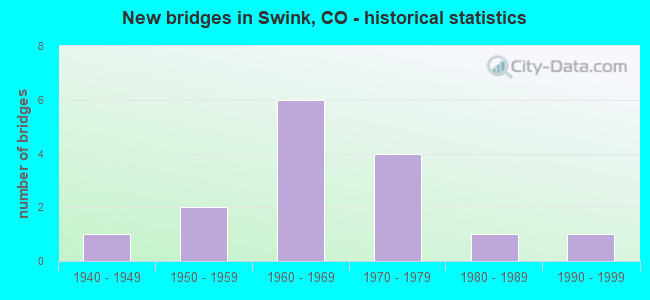
- New bridges - historical statistics
- 11940-1949
- 21950-1959
- 61960-1969
- 41970-1979
- 11980-1989
- 11990-1999
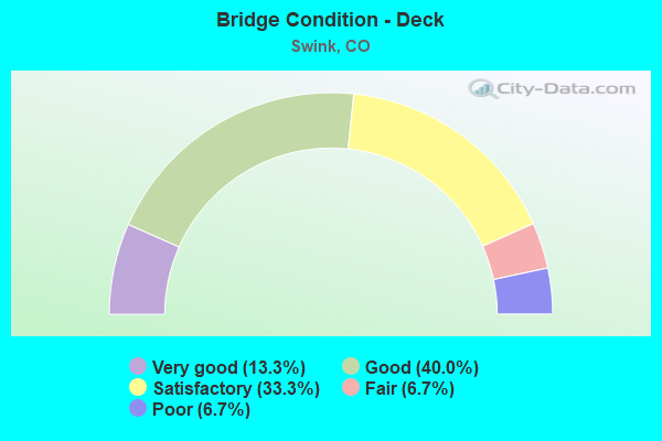
- Bridge Condition - Deck
- 13.3%Very good
- 40.0%Good
- 33.3%Satisfactory
- 6.7%Fair
- 6.7%Poor
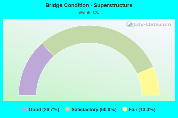
- Bridge Condition - Superstructure
- 26.7%Good
- 60.0%Satisfactory
- 13.3%Fair
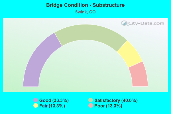
- Bridge Condition - Substructure
- 33.3%Good
- 40.0%Satisfactory
- 13.3%Fair
- 13.3%Poor
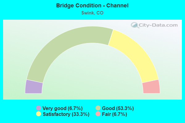
- Bridge Condition - Channel
- 6.7%Very good
- 53.3%Good
- 33.3%Satisfactory
- 6.7%Fair
Find on map >> Show street view
Structure Number: L-22-A, Location: 0.8 MI WEST OF SWINK (Lat: 38.021389, Lng: -103.639486), Route carried "on" structure: US 50B, Year Built: 1947, Status: Open, Structure Length: 6.83m (22.41ft), Average Daily Traffic: 4,700 (year 2020), Truck Traffic: 8%, Average Future Daily Traffic: 4,747 (year 2040), Design Load: HS 20, Features Intersected: TIMPAS CREEK, Facility Carried by Structure: US 50 ML WBND
Minimum Vertical Clearance: 30+ m (98+ ft), Kilometerpoint: 93.279, Lanes on structure: 2, Base Highway Network: Yes, Owner: State Highway Agency, Approaching Roadway Width: 11.6m (38.1ft), Skew: 12 degrees, Material/Design: Steel continuous, Design/Construction: Tee Beam, Number Of Spans In Main Unit: 3, Length of Maximum Span: 26.8m (87.9ft), Curb or Sidewalk Widths: Left: 0.6m (2.0ft), Right: 0.6m (2.0ft), Curb-To-Curb Width: 9.1m (29.9ft), Out-to-Out Width: 10.4m (34.1ft)
Condition: Deck: Fair, Superstructure: Fair, Substructure: Satisfactory, Channel: Good, Operating Rating: 48.7 metric tons, Method Used To Determine Operating Rating: Load Factor (LF), Inventory Rating: 29.2 metric tons, Method Used To Determine Inventory Rating: Load Factor (LF), Structural Evaluation: Somewhat better than minimum adequacy, Deck Geometry: Meets minimum limits, Waterway Adequacy: Equal to present minimum criteria, Approach Roadway Alignment: Equal to present desirable criteria, Designated Inspection Frequency: Every 24 months, Inspection Date: January 2022, Deck Structure Type: Concrete Cast-file-Place, Wearing Surface/Protective System: Wearing Surface: Bituminous
Find on map >> Show street view
Structure Number: L-22-AL, Location: .8 MI W. OF SWINK (Lat: 38.021253, Lng: -103.639617), Route carried "on" structure: US 50B, Year Built: 1958, Status: Open, Structure Length: 8.17m (26.80ft), Average Daily Traffic: 4,700 (year 2020), Truck Traffic: 8%, Average Future Daily Traffic: 4,747 (year 2040), Design Load: HS 20, Features Intersected: TIMPAS CREEK, Facility Carried by Structure: US 50 ML EBND
Minimum Vertical Clearance: 30+ m (98+ ft), Kilometerpoint: 93.270, Lanes on structure: 2, Base Highway Network: Yes, Owner: State Highway Agency, Approaching Roadway Width: 11.6m (38.1ft), Skew: 12 degrees, Material/Design: Prestressed concrete, Design/Construction: Stringer/Multi-beam, Number Of Spans In Main Unit: 3, Length of Maximum Span: 26.2m (86.0ft), Curb or Sidewalk Widths: Left: 0.6m (2.0ft), Right: 0.6m (2.0ft), Curb-To-Curb Width: 9.1m (29.9ft), Out-to-Out Width: 10.4m (34.1ft)
Condition: Deck: Satisfactory, Superstructure: Satisfactory, Substructure: Fair, Channel: Good, Operating Rating: 49.4 metric tons, Method Used To Determine Operating Rating: Load Factor (LF), Inventory Rating: 9.5 metric tons, Method Used To Determine Inventory Rating: Load Factor (LF), Structural Evaluation: High priority of corrective action, Deck Geometry: Meets minimum limits, Waterway Adequacy: Equal to present minimum criteria, Approach Roadway Alignment: Equal to present desirable criteria, Designated Inspection Frequency: Every 24 months, Inspection Date: January 2022, Deck Structure Type: Concrete Cast-file-Place, Wearing Surface/Protective System: Wearing Surface: Bituminous
Find on map >> Show street view
Structure Number: L-22-BB, Location: 4.9 MI NE OF ROCKY FORD (Lat: 38.068828, Lng: -103.636650), Route carried "on" structure: State highway 266A, Year Built: 1954, Year Reconstructed: 1987, Status: Open, Structure Length: 3.82m (12.53ft), Average Daily Traffic: 330 (year 2020), Truck Traffic: 8%, Average Future Daily Traffic: 422 (year 2040), Design Load: H 20, Features Intersected: FT LYON STORAGE CANAL, Facility Carried by Structure: SH 266 ML
Minimum Vertical Clearance: 30+ m (98+ ft), Kilometerpoint: 8.039, Lanes on structure: 2, Owner: State Highway Agency, Approaching Roadway Width: 6.7m (22.0ft), Skew: 4 degrees, Material/Design: Steel continuous, Design/Construction: Stringer/Multi-beam, Number Of Spans In Main Unit: 3, Length of Maximum Span: 14.0m (45.9ft), Curb-To-Curb Width: 10.4m (34.1ft), Out-to-Out Width: 11.1m (36.4ft)
Condition: Deck: Satisfactory, Superstructure: Good, Substructure: Satisfactory, Channel: Very good, Operating Rating: 51.3 metric tons, Method Used To Determine Operating Rating: Load Factor (LF), Inventory Rating: 30.8 metric tons, Method Used To Determine Inventory Rating: Load Factor (LF), Structural Evaluation: Equal to present minimum criteria, Deck Geometry: Better than present minimum criteria, Waterway Adequacy: Equal to present desirable criteria, Approach Roadway Alignment: Equal to present desirable criteria, Designated Inspection Frequency: Every 24 months, Inspection Date: Febuary 2022, Deck Structure Type: Concrete Cast-file-Place, Wearing Surface/Protective System: Wearing Surface: Bituminous, Membrane: Preformed Fabric, Deck Protection: Epoxy Coated Reinforcing
Find on map >> Show street view
Structure Number: OT-22-21-22-119, Location: .5 MI S OF SH 10 (Lat: 37.975111, Lng: -103.674667), Route carried "on" structure: County highway , Year Built: 1966, Status: Open, Structure Length: 0.93m (3.05ft), Average Daily Traffic: 96 (year 2018), Average Future Daily Traffic: 141 (year 2038), Features Intersected: CATLIN CANAL, Facility Carried by Structure: COUNTY ROAD 22
Minimum Vertical Clearance: 30+ m (98+ ft), Kilometerpoint: 0.837, Lanes on structure: 2, Owner: County Highway Agency, Approaching Roadway Width: 5.8m (19.0ft), Material/Design: Steel, Design/Construction: Stringer/Multi-beam, Number Of Spans In Main Unit: 1, Length of Maximum Span: 8.1m (26.6ft), Curb-To-Curb Width: 7.1m (23.3ft), Out-to-Out Width: 7.3m (24.0ft)
Condition: Deck: Poor, Superstructure: Satisfactory, Substructure: Good, Channel: Good, Operating Rating: 32.9 metric tons, Method Used To Determine Operating Rating: Load Factor (LF), Inventory Rating: 19.8 metric tons, Method Used To Determine Inventory Rating: Load Factor (LF), Structural Evaluation: Somewhat better than minimum adequacy, Deck Geometry: Somewhat better than minimum adequacy, Waterway Adequacy: Equal to present desirable criteria, Approach Roadway Alignment: Equal to present desirable criteria, Designated Inspection Frequency: Every 24 months, Inspection Date: November 2021, Deck Structure Type: Corrugated Steel, Wearing Surface/Protective System: Wearing Surface: Bituminous
Find on map >> Show street view
Structure Number: OT-22-21-24-118, Location: .1 MI S OF CR BB (Lat: 37.996194, Lng: -103.674389), Route carried "on" structure: County highway , Year Built: 1971, Status: Open, Structure Length: 4.61m (15.12ft), Average Daily Traffic: 274 (year 2018), Truck Traffic: 2%, Average Future Daily Traffic: 403 (year 2038), Features Intersected: TIMPAS CREEK, Facility Carried by Structure: COUNTY ROAD 22
Minimum Vertical Clearance: 30+ m (98+ ft), Kilometerpoint: 3.114, Lanes on structure: 2, Owner: County Highway Agency, Approaching Roadway Width: 7.6m (24.9ft), Material/Design: Steel, Design/Construction: Stringer/Multi-beam, Number Of Spans In Main Unit: 3, Length of Maximum Span: 14.9m (48.9ft), Curb-To-Curb Width: 7.6m (24.9ft), Out-to-Out Width: 8.6m (28.2ft)
Condition: Deck: Good, Superstructure: Good, Substructure: Satisfactory, Channel: Satisfactory, Operating Rating: 63.1 metric tons, Method Used To Determine Operating Rating: Load Factor (LF), Inventory Rating: 37.7 metric tons, Method Used To Determine Inventory Rating: Load Factor (LF), Structural Evaluation: Equal to present minimum criteria, Deck Geometry: Somewhat better than minimum adequacy, Waterway Adequacy: Equal to present desirable criteria, Approach Roadway Alignment: Equal to present desirable criteria, Designated Inspection Frequency: Every 24 months, Inspection Date: November 2021, Deck Structure Type: Concrete Cast-file-Place, Wearing Surface/Protective System: Wearing Surface: Bituminous
Find on map >> Show street view
Structure Number: OT-22-21-25-116, Location: .4 MI S OF CR CC (Lat: 38.006000, Lng: -103.674333), Route carried "on" structure: County highway , Year Built: 1968, Status: Posted for load-capacity, Structure Length: 0.94m (3.08ft), Average Daily Traffic: 362 (year 2018), Truck Traffic: 2%, Average Future Daily Traffic: 532 (year 2038), Features Intersected: ROCKY FORD CANAL, Facility Carried by Structure: COUNTY ROAD 22
Minimum Vertical Clearance: 30+ m (98+ ft), Kilometerpoint: 4.222, Lanes on structure: 2, Owner: County Highway Agency, Approaching Roadway Width: 7.0m (23.0ft), Skew: 4 degrees, Material/Design: Steel, Design/Construction: Stringer/Multi-beam, Number Of Spans In Main Unit: 1, Length of Maximum Span: 8.4m (27.6ft), Curb-To-Curb Width: 8.0m (26.2ft), Out-to-Out Width: 8.0m (26.2ft)
Condition: Deck: Good, Superstructure: Satisfactory, Substructure: Satisfactory, Channel: Satisfactory, Operating Rating: 27.1 metric tons, Method Used To Determine Operating Rating: Load Factor (LF), Inventory Rating: 16.2 metric tons, Method Used To Determine Inventory Rating: Load Factor (LF), Structural Evaluation: Somewhat better than minimum adequacy, Deck Geometry: Somewhat better than minimum adequacy, Waterway Adequacy: Equal to present desirable criteria, Approach Roadway Alignment: Equal to present desirable criteria, Bridge Posting: Required (Relationship of Operating Rating to Maximum Legal Load: 10.0 - 19.9% below), Designated Inspection Frequency: Every 24 months, Inspection Date: November 2021, Deck Structure Type: Concrete Cast-file-Place, Wearing Surface/Protective System: Wearing Surface: Bituminous
Find on map >> Show street view
Structure Number: OT-23-22-22-126, Location: .1 MI N OF CR 2 (Lat: 37.970194, Lng: -103.656333), Route carried "on" structure: County highway , Year Built: 1969, Status: Open, Structure Length: 0.96m (3.15ft), Average Daily Traffic: 120 (year 2018), Truck Traffic: 2%, Average Future Daily Traffic: 176 (year 2038), Features Intersected: CATLIN CANAL, Facility Carried by Structure: COUNTY ROAD 23
Minimum Vertical Clearance: 30+ m (98+ ft), Kilometerpoint: 1.891, Lanes on structure: 2, Owner: County Highway Agency, Approaching Roadway Width: 7.3m (24.0ft), Skew: 3 degrees, Material/Design: Steel, Design/Construction: Stringer/Multi-beam, Number Of Spans In Main Unit: 1, Length of Maximum Span: 8.7m (28.5ft), Curb-To-Curb Width: 7.4m (24.3ft), Out-to-Out Width: 7.4m (24.3ft)
Condition: Deck: Very good, Superstructure: Satisfactory, Substructure: Good, Channel: Satisfactory, Operating Rating: 52.8 metric tons, Method Used To Determine Operating Rating: Load Factor (LF), Inventory Rating: 31.6 metric tons, Method Used To Determine Inventory Rating: Load Factor (LF), Structural Evaluation: Equal to present minimum criteria, Deck Geometry: Somewhat better than minimum adequacy, Waterway Adequacy: Equal to present desirable criteria, Approach Roadway Alignment: Equal to present desirable criteria, Designated Inspection Frequency: Every 24 months, Inspection Date: November 2021, Deck Structure Type: Concrete Cast-file-Place, Wearing Surface/Protective System: Wearing Surface: Bituminous
Find on map >> Show street view
Structure Number: OT-BB-20-24-117, Location: .5 MI E OF CR 21 (Lat: 37.996972, Lng: -103.683444), Route carried "on" structure: County highway , Year Built: 1967, Status: Open, Structure Length: 0.74m (2.43ft), Average Daily Traffic: 133 (year 2018), Average Future Daily Traffic: 195 (year 2038), Features Intersected: ROCKY FORD CANAL, Facility Carried by Structure: COUNTY ROAD BB
Minimum Vertical Clearance: 30+ m (98+ ft), Kilometerpoint: 0.835, Lanes on structure: 2, Owner: County Highway Agency, Approaching Roadway Width: 7.3m (24.0ft), Skew: 3 degrees, Material/Design: Steel, Design/Construction: Stringer/Multi-beam, Number Of Spans In Main Unit: 1, Length of Maximum Span: 6.4m (21.0ft), Curb-To-Curb Width: 7.1m (23.3ft), Out-to-Out Width: 7.2m (23.6ft)
Condition: Deck: Satisfactory, Superstructure: Satisfactory, Substructure: Satisfactory, Channel: Satisfactory, Operating Rating: 42.5 metric tons, Method Used To Determine Operating Rating: Load Factor (LF), Inventory Rating: 25.4 metric tons, Method Used To Determine Inventory Rating: Load Factor (LF), Structural Evaluation: Equal to present minimum criteria, Deck Geometry: Meets minimum limits, Waterway Adequacy: Equal to present desirable criteria, Approach Roadway Alignment: Equal to present desirable criteria, Designated Inspection Frequency: Every 24 months, Inspection Date: November 2021, Deck Structure Type: Concrete Cast-file-Place, Wearing Surface/Protective System: Wearing Surface: Monolithic Concrete
Find on map >> Show street view
Structure Number: OT-CC-22-25-124, Location: .5 MI W OF CR 24 (Lat: 38.011139, Lng: -103.646500), Route carried "on" structure: County highway , Year Built: 1975, Status: Open, Structure Length: 4.65m (15.26ft), Average Daily Traffic: 617 (year 2018), Truck Traffic: 2%, Average Future Daily Traffic: 907 (year 2038), Features Intersected: TIMPAS CREEK, Facility Carried by Structure: COUNTY ROAD CC
Minimum Vertical Clearance: 30+ m (98+ ft), Kilometerpoint: 6.519, Lanes on structure: 2, Owner: County Highway Agency, Approaching Roadway Width: 7.0m (23.0ft), Material/Design: Prestressed concrete, Design/Construction: Tee Beam, Number Of Spans In Main Unit: 3, Length of Maximum Span: 24.0m (78.7ft), Curb-To-Curb Width: 7.8m (25.6ft), Out-to-Out Width: 8.3m (27.2ft)
Condition: Deck: Satisfactory, Superstructure: Satisfactory, Substructure: Satisfactory, Channel: Satisfactory, Operating Rating: 36.3 metric tons, Method Used To Determine Operating Rating: Field evaluation and documented engineering judgment, Inventory Rating: 32.7 metric tons, Method Used To Determine Inventory Rating: Field evaluation and documented engineering judgment, Structural Evaluation: Equal to present minimum criteria, Deck Geometry: Meets minimum limits, Waterway Adequacy: Equal to present desirable criteria, Approach Roadway Alignment: Equal to present desirable criteria, Designated Inspection Frequency: Every 24 months, Inspection Date: November 2021, Deck Structure Type: Other, Wearing Surface/Protective System: Wearing Surface: Bituminous
Find on map >> Show street view
Structure Number: OT-DD-24-26-147, Location: .5 MI E OF CR 24.5 (Lat: 38.030333, Lng: -103.619472), Route carried "on" structure: County highway , Year Built: 1970, Status: Open, Structure Length: 0.96m (3.15ft), Average Daily Traffic: 105 (year 2018), Truck Traffic: 2%, Average Future Daily Traffic: 154 (year 2038), Features Intersected: HOLBROOK RES LATERAL, Facility Carried by Structure: COUNTY ROAD DD
Minimum Vertical Clearance: 30+ m (98+ ft), Kilometerpoint: 0.940, Lanes on structure: 2, Owner: County Highway Agency, Approaching Roadway Width: 7.0m (23.0ft), Material/Design: Steel, Design/Construction: Stringer/Multi-beam, Number Of Spans In Main Unit: 1, Length of Maximum Span: 8.6m (28.2ft), Curb-To-Curb Width: 7.4m (24.3ft), Out-to-Out Width: 7.4m (24.3ft)
Condition: Deck: Satisfactory, Superstructure: Satisfactory, Substructure: Poor, Channel: Fair, Operating Rating: 35.6 metric tons, Method Used To Determine Operating Rating: Load Factor (LF), Inventory Rating: 21.3 metric tons, Method Used To Determine Inventory Rating: Load Factor (LF), Structural Evaluation: Meets minimum limits, Deck Geometry: Somewhat better than minimum adequacy, Waterway Adequacy: Better than present minimum criteria, Approach Roadway Alignment: Equal to present minimum criteria, Designated Inspection Frequency: Every 24 months, Inspection Date: November 2021, Deck Structure Type: Concrete Cast-file-Place, Wearing Surface/Protective System: Wearing Surface: Monolithic Concrete
Find on map >> Show street view
Structure Number: OT-FF-25-28-153, Location: .1 MI W OF CR 26 (Lat: 38.054972, Lng: -103.602139), Route carried "on" structure: County highway , Year Built: 1971, Status: Open, Structure Length: 0.96m (3.15ft), Average Daily Traffic: 364 (year 2018), Truck Traffic: 2%, Average Future Daily Traffic: 536 (year 2038), Features Intersected: HOLBROOK RES. LATERAL, Facility Carried by Structure: COUNTY ROAD FF
Minimum Vertical Clearance: 30+ m (98+ ft), Kilometerpoint: 5.419, Lanes on structure: 2, Owner: County Highway Agency, Approaching Roadway Width: 5.8m (19.0ft), Skew: 2 degrees, Material/Design: Steel, Design/Construction: Stringer/Multi-beam, Number Of Spans In Main Unit: 1, Length of Maximum Span: 8.8m (28.9ft), Curb-To-Curb Width: 7.4m (24.3ft), Out-to-Out Width: 7.4m (24.3ft)
Condition: Deck: Very good, Superstructure: Fair, Substructure: Good, Channel: Good, Operating Rating: 34.4 metric tons, Method Used To Determine Operating Rating: Load Factor (LF), Inventory Rating: 20.6 metric tons, Method Used To Determine Inventory Rating: Load Factor (LF), Structural Evaluation: Somewhat better than minimum adequacy, Deck Geometry: Somewhat better than minimum adequacy, Waterway Adequacy: Equal to present desirable criteria, Approach Roadway Alignment: Equal to present desirable criteria, Designated Inspection Frequency: Every 24 months, Inspection Date: November 2021, Deck Structure Type: Concrete Cast-file-Place, Wearing Surface/Protective System: Wearing Surface: Bituminous
Find on map >> Show street view
Structure Number: OT23-22-24-125A, Location: .6 MI S OF CR CC (Lat: 38.002889, Lng: -103.655861), Route carried "on" structure: County highway , Year Built: 1997, Status: Open, Structure Length: 5.18m (16.99ft), Average Daily Traffic: 171 (year 2018), Average Future Daily Traffic: 252 (year 2038), Design Load: HS 25 or greater, Features Intersected: TIMPAS CREEK, Facility Carried by Structure: COUNTY ROAD 23
Minimum Vertical Clearance: 30+ m (98+ ft), Kilometerpoint: 5.591, Lanes on structure: 2, Owner: County Highway Agency, Approaching Roadway Width: 8.5m (27.9ft), Material/Design: Prestressed concrete continuous, Design/Construction: Box Beam or Girders - Single/Spread, Number Of Spans In Main Unit: 3, Length of Maximum Span: 20.9m (68.6ft), Curb-To-Curb Width: 9.1m (29.9ft), Out-to-Out Width: 9.9m (32.5ft)
Condition: Deck: Good, Superstructure: Good, Substructure: Good, Channel: Good, Operating Rating: 89.8 metric tons, Method Used To Determine Operating Rating: Load Factor (LF), Inventory Rating: 55.8 metric tons, Method Used To Determine Inventory Rating: Load Factor (LF), Structural Evaluation: Better than present minimum criteria, Deck Geometry: Equal to present minimum criteria, Waterway Adequacy: Equal to present desirable criteria, Approach Roadway Alignment: Equal to present minimum criteria, Designated Inspection Frequency: Every 24 months, Inspection Date: November 2021, Deck Structure Type: Concrete Cast-file-Place, Wearing Surface/Protective System: Wearing Surface: Bituminous, Deck Protection: Epoxy Coated Reinforcing
Find on map >> Show street view
Structure Number: OT24-23-22-129, Location: .9 MI S OF SH 10 (Lat: 37.968750, Lng: -103.638028), Route carried "on" structure: County highway , Year Built: 1967, Status: Open, Structure Length: 0.74m (2.43ft), Average Daily Traffic: 215 (year 2018), Truck Traffic: 2%, Average Future Daily Traffic: 316 (year 2038), Features Intersected: CATLIN CANAL, Facility Carried by Structure: COUNTY ROAD 24
Minimum Vertical Clearance: 30+ m (98+ ft), Kilometerpoint: 5.805, Lanes on structure: 2, Owner: County Highway Agency, Approaching Roadway Width: 6.1m (20.0ft), Skew: 2 degrees, Material/Design: Steel, Design/Construction: Stringer/Multi-beam, Number Of Spans In Main Unit: 1, Length of Maximum Span: 6.6m (21.7ft), Curb-To-Curb Width: 7.1m (23.3ft), Out-to-Out Width: 7.3m (24.0ft)
Condition: Deck: Good, Superstructure: Satisfactory, Substructure: Fair, Channel: Good, Operating Rating: 36.5 metric tons, Method Used To Determine Operating Rating: Load Factor (LF), Inventory Rating: 21.8 metric tons, Method Used To Determine Inventory Rating: Load Factor (LF), Structural Evaluation: Somewhat better than minimum adequacy, Deck Geometry: Meets minimum limits, Waterway Adequacy: Equal to present desirable criteria, Approach Roadway Alignment: Equal to present desirable criteria, Designated Inspection Frequency: Every 24 months, Inspection Date: November 2021, Deck Structure Type: Concrete Cast-file-Place, Wearing Surface/Protective System: Wearing Surface: Bituminous
Find on map >> Show street view
Structure Number: OT245-2426-138A, Location: 0.9 MI N OF SWINK (Lat: 38.026778, Lng: -103.628222), Route carried "on" structure: County highway , Year Built: 1986, Status: Open, Structure Length: 9.50m (31.17ft), Average Daily Traffic: 1,319 (year 2018), Truck Traffic: 2%, Average Future Daily Traffic: 1,940 (year 2038), Design Load: HS 20+Mod, Features Intersected: ARKANSAS RIVER, Facility Carried by Structure: COUNTY ROAD 24.5
Minimum Vertical Clearance: 30+ m (98+ ft), Kilometerpoint: 1.248, Lanes on structure: 2, Owner: County Highway Agency, Approaching Roadway Width: 7.6m (24.9ft), Skew: 3 degrees, Material/Design: Prestressed concrete continuous, Design/Construction: Stringer/Multi-beam, Number Of Spans In Main Unit: 3, Length of Maximum Span: 30.3m (99.4ft), Curb-To-Curb Width: 10.4m (34.1ft), Out-to-Out Width: 11.1m (36.4ft)
Condition: Deck: Good, Superstructure: Good, Substructure: Good, Channel: Good, Operating Rating: 66.0 metric tons, Method Used To Determine Operating Rating: Load Factor (LF), Inventory Rating: 36.6 metric tons, Method Used To Determine Inventory Rating: Load Factor (LF), Structural Evaluation: Better than present minimum criteria, Deck Geometry: Equal to present minimum criteria, Waterway Adequacy: Equal to present desirable criteria, Approach Roadway Alignment: Better than present minimum criteria, Designated Inspection Frequency: Every 24 months, Inspection Date: November 2021, Deck Structure Type: Concrete Cast-file-Place, Wearing Surface/Protective System: Wearing Surface: Bituminous, Membrane: Preformed Fabric, Deck Protection: Epoxy Coated Reinforcing
Find on map >> Show street view
Structure Number: OTCC5-21-25-113, Location: .1 MI E OF CR 22 (Lat: 38.018583, Lng: -103.673167), Route carried "on" structure: County highway , Year Built: 1964, Status: Open, Structure Length: 0.73m (2.40ft), Average Daily Traffic: 25 (year 2018), Average Future Daily Traffic: 37 (year 2038), Features Intersected: ROCKY FORD CANAL, Facility Carried by Structure: COUNTY ROAD CC.5
Minimum Vertical Clearance: 30+ m (98+ ft), Kilometerpoint: 0.095, Lanes on structure: 2, Owner: County Highway Agency, Approaching Roadway Width: 5.8m (19.0ft), Skew: 5 degrees, Material/Design: Steel, Design/Construction: Stringer/Multi-beam, Number Of Spans In Main Unit: 1, Length of Maximum Span: 6.2m (20.3ft), Curb-To-Curb Width: 6.0m (19.7ft), Out-to-Out Width: 6.2m (20.3ft)
Condition: Deck: Good, Superstructure: Satisfactory, Substructure: Poor, Channel: Good, Operating Rating: 45.9 metric tons, Method Used To Determine Operating Rating: Load Factor (LF), Inventory Rating: 27.5 metric tons, Method Used To Determine Inventory Rating: Load Factor (LF), Structural Evaluation: Meets minimum limits, Deck Geometry: Meets minimum limits, Waterway Adequacy: Equal to present desirable criteria, Approach Roadway Alignment: Equal to present desirable criteria, Designated Inspection Frequency: Every 24 months, Inspection Date: November 2021, Deck Structure Type: Concrete Cast-file-Place, Wearing Surface/Protective System: Wearing Surface: Monolithic Concrete