Bridge Statistics for Taylor Mill, Kentucky (KY)
Condition, Traffic, Stress, Structural Evaluation, Project Costs
- National Bridge Inventory (NBI) Statistics
- 14Number of bridges
- 459ft / 140mTotal length
- $1,668,000Total costs
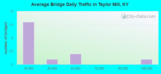
- 260,546Total average daily traffic
- 19,089Total average daily truck traffic
- National Bridge Inventory (NBI) Registered Bridges for Taylor Mill
- No street view available for this location
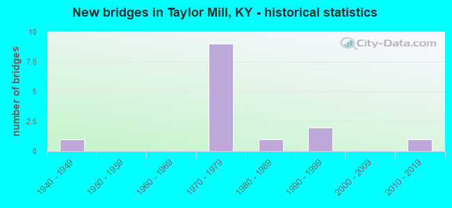
- New bridges - historical statistics
- 11940-1949
- 91970-1979
- 11980-1989
- 21990-1999
- 12010-2019
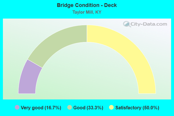
- Bridge Condition - Deck
- 16.7%Very good
- 33.3%Good
- 50.0%Satisfactory
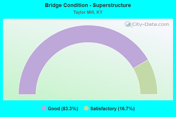
- Bridge Condition - Superstructure
- 83.3%Good
- 16.7%Satisfactory
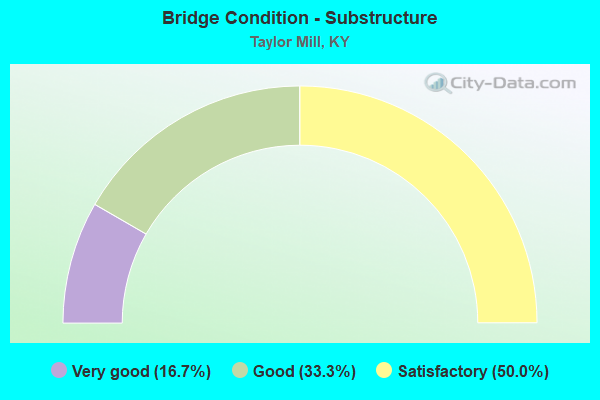
- Bridge Condition - Substructure
- 16.7%Very good
- 33.3%Good
- 50.0%Satisfactory
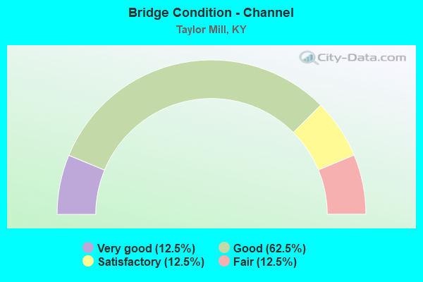
- Bridge Condition - Channel
- 12.5%Very good
- 62.5%Good
- 12.5%Satisfactory
- 12.5%Fair
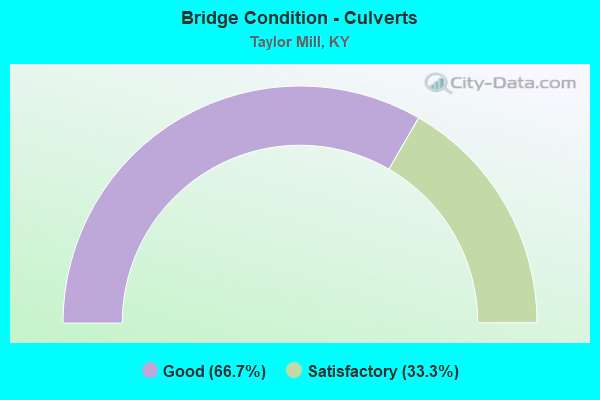
- Bridge Condition - Culverts
- 66.7%Good
- 33.3%Satisfactory
Find on map >> Show street view
Structure Number: 59B00050N, Location: 1.6 MI S OF JCT KY 177 (Lat: 39.021944, Lng: -84.511667), Route carried "on" structure: State highway 16, Year Built: 1973, Status: Open, Structure Length: 7.07m (23.20ft), Average Daily Traffic: 27,020 (year 2018), Truck Traffic: 4%, Average Future Daily Traffic: 25,128 (year 2038), Design Load: HS 20+Mod, Features Intersected: I 275, Facility Carried by Structure: TAYLOR MILL ROAD
Minimum Vertical Clearance: 30+ m (98+ ft), Kilometerpoint: 20.934, Lanes on structure: 4, Lanes under structure: 6, Owner: State Highway Agency, Approaching Roadway Width: 41.5m (136.2ft), Skew: 20 degrees, Material/Design: Steel continuous, Design/Construction: Stringer/Multi-beam, Number Of Spans In Main Unit: 2, Length of Maximum Span: 35.4m (116.1ft), Curb or Sidewalk Widths: Left: 0.5m (1.6ft), Right: 0.5m (1.6ft), Curb-To-Curb Width: 34.1m (111.9ft), Out-to-Out Width: 35.4m (116.1ft)
Condition: Deck: Very good, Superstructure: Good, Substructure: Good, Operating Rating: 83.4 metric tons, Method Used To Determine Operating Rating: Load Factor (LF), Inventory Rating: 50.1 metric tons, Method Used To Determine Inventory Rating: Load Factor (LF), Structural Evaluation: Better than present minimum criteria, Deck Geometry: Superior to present desirable criteria, Underclear: Superior to present desirable criteria, Approach Roadway Alignment: Equal to present minimum criteria, Designated Inspection Frequency: Every 24 months, Inspection Date: October 2021, Deck Structure Type: Concrete Cast-file-Place, Wearing Surface/Protective System: Wearing Surface: Monolithic Concrete, Deck Protection: Epoxy Coated Reinforcing
Find on map >> Show street view
Structure Number: 59B00052L, Location: WBL @CAMPBELL CO LN. (Lat: 39.022500, Lng: -84.489722), Route carried "on" structure: Interstate 275, Year Built: 1973, Status: Open, Structure Length: 46.54m (152.69ft), Average Daily Traffic: 48,605 (year 2020), Truck Traffic: 9%, Average Future Daily Traffic: 52,007 (year 2040), Design Load: HS 20+Mod, Features Intersected: CSX RR-KY 177-LICKNG RVR
Minimum Vertical Clearance: 30+ m (98+ ft), Kilometerpoint: 124.978, Lanes on structure: 3, Lanes under structure: 3, Base Highway Network: Yes, Owner: State Highway Agency, Approaching Roadway Width: 17.1m (56.1ft), Skew: 10 degrees, Navigation Control: Yes ( Vertical Clearance: 18.3m (60.0ft), Horizontal Clearance: 79.9m (262.1ft)), Material/Design: Steel continuous, Design/Construction: Stringer/Multi-beam, Number Of Spans In Main Unit: 9, Length of Maximum Span: 67.1m (220.1ft), Curb or Sidewalk Widths: Left: 0.5m (1.6ft), Right: 0.5m (1.6ft), Curb-To-Curb Width: 15.5m (50.9ft), Out-to-Out Width: 16.8m (55.1ft)
Condition: Deck: Satisfactory, Superstructure: Satisfactory, Substructure: Satisfactory, Channel: Good, Operating Rating: 57.3 metric tons, Method Used To Determine Operating Rating: Load Factor (LF), Inventory Rating: 34.4 metric tons, Method Used To Determine Inventory Rating: Load Factor (LF), Structural Evaluation: Equal to present minimum criteria, Deck Geometry: Somewhat better than minimum adequacy, Underclear: Superior to present desirable criteria, Waterway Adequacy: Superior to present desirable criteria, Approach Roadway Alignment: Superior to present desirable criteria, Designated Inspection Frequency: Every 24 months, Underwater Inspection Frequency: Every 60 months, Inspection Date: October 2021, Underwater Inspection Date: May 2019, Deck Structure Type: Concrete Cast-file-Place, Wearing Surface/Protective System: Wearing Surface: Latex Concrete
Find on map >> Show street view
Structure Number: 59B00052R, Location: EBL @CAMPBELL CO.LN. (Lat: 39.022500, Lng: -84.489722), Route carried "on" structure: Interstate 275, Year Built: 1972, Status: Open, Structure Length: 46.54m (152.69ft), Average Daily Traffic: 48,605 (year 2020), Truck Traffic: 9%, Average Future Daily Traffic: 52,007 (year 2040), Design Load: HS 20+Mod, Features Intersected: CSX RR-KY 177-LICKNG RVR
Minimum Vertical Clearance: 30+ m (98+ ft), Kilometerpoint: 124.980, Lanes on structure: 3, Lanes under structure: 3, Base Highway Network: Yes, Owner: State Highway Agency, Approaching Roadway Width: 28.7m (94.2ft), Skew: 10 degrees, Navigation Control: Yes ( Vertical Clearance: 18.3m (60.0ft), Horizontal Clearance: 79.9m (262.1ft)), Material/Design: Steel continuous, Design/Construction: Stringer/Multi-beam, Number Of Spans In Main Unit: 9, Length of Maximum Span: 67.1m (220.1ft), Curb or Sidewalk Widths: Left: 0.5m (1.6ft), Right: 0.5m (1.6ft), Curb-To-Curb Width: 15.5m (50.9ft), Out-to-Out Width: 16.5m (54.1ft)
Condition: Deck: Satisfactory, Superstructure: Good, Substructure: Satisfactory, Channel: Good, Operating Rating: 57.3 metric tons, Method Used To Determine Operating Rating: Load Factor (LF), Inventory Rating: 34.4 metric tons, Method Used To Determine Inventory Rating: Load Factor (LF), Structural Evaluation: Equal to present minimum criteria, Deck Geometry: Somewhat better than minimum adequacy, Underclear: Superior to present desirable criteria, Waterway Adequacy: Superior to present desirable criteria, Approach Roadway Alignment: Superior to present desirable criteria, Designated Inspection Frequency: Every 24 months, Underwater Inspection Frequency: Every 60 months, Inspection Date: October 2021, Underwater Inspection Date: May 2019, Bridge Improvement Cost: $1,575,000, Total Project Cost: $1,575,000, Deck Structure Type: Concrete Cast-file-Place, Wearing Surface/Protective System: Wearing Surface: Latex Concrete
Find on map >> Show street view
Structure Number: 59B00082N, Location: .80 MI SW OF JCT KY 177 (Lat: 39.036667, Lng: -84.509722), Route carried "on" structure: State highway 16, Year Built: 1985, Status: Open, Structure Length: 8.56m (28.08ft), Average Daily Traffic: 17,907 (year 2020), Truck Traffic: 5%, Average Future Daily Traffic: 16,832 (year 2040), Design Load: HS 20, Features Intersected: BANKLICK CREEK, Facility Carried by Structure: WINSTON AVENUE
Minimum Vertical Clearance: 30+ m (98+ ft), Kilometerpoint: 22.658, Lanes on structure: 4, Base Highway Network: Yes, Owner: State Highway Agency, Approaching Roadway Width: 21.3m (69.9ft), Skew: 1 degrees, Material/Design: Prestressed concrete continuous, Design/Construction: Stringer/Multi-beam, Number Of Spans In Main Unit: 3, Length of Maximum Span: 29.3m (96.1ft), Curb or Sidewalk Widths: Left: 2.1m (6.9ft), Right: 2.1m (6.9ft), Curb-To-Curb Width: 21.3m (69.9ft), Out-to-Out Width: 26.0m (85.3ft)
Condition: Deck: Satisfactory, Superstructure: Good, Substructure: Good, Channel: Good, Operating Rating: 99.4 metric tons, Method Used To Determine Operating Rating: Load Factor (LF), Inventory Rating: 59.7 metric tons, Method Used To Determine Inventory Rating: Load Factor (LF), Structural Evaluation: Better than present minimum criteria, Deck Geometry: Superior to present desirable criteria, Waterway Adequacy: Equal to present desirable criteria, Approach Roadway Alignment: Equal to present minimum criteria, Designated Inspection Frequency: Every 24 months, Inspection Date: November 2021, Deck Structure Type: Concrete Cast-file-Place, Wearing Surface/Protective System: Wearing Surface: Monolithic Concrete, Deck Protection: Epoxy Coated Reinforcing
Find on map >> Show street view
Structure Number: 59B00114N, Location: 0.2 MI. E OF JCT KY 1930 (Lat: 39.009722, Lng: -84.484722), Route carried "on" structure: State highway 1930, Year Built: 1943, Status: Posted for load, Structure Length: 1.21m (3.97ft), Average Daily Traffic: 967 (year 2018), Average Future Daily Traffic: 908 (year 2038), Features Intersected: DECORSEY CREEK
Minimum Vertical Clearance: 30+ m (98+ ft), Kilometerpoint: 9.363, Lanes on structure: 2, Owner: State Highway Agency, Approaching Roadway Width: 6.6m (21.7ft), Material/Design: Concrete, Design/Construction: Culvert, Number Of Spans In Main Unit: 1, Length of Maximum Span: 12.1m (39.7ft)
Condition: Channel: Satisfactory, Culverts: Satisfactory, Operating Rating: 36.3 metric tons, Method Used To Determine Operating Rating: Field evaluation and documented engineering judgment, Inventory Rating: 18.1 metric tons, Method Used To Determine Inventory Rating: Field evaluation and documented engineering judgment, Structural Evaluation: Somewhat better than minimum adequacy, Waterway Adequacy: Meets minimum limits, Approach Roadway Alignment: Equal to present minimum criteria, Bridge Posting: Required (Relationship of Operating Rating to Maximum Legal Load: > 39.9% below), Designated Inspection Frequency: Every 24 months, Inspection Date: November 2021
Find on map >> Show street view
Structure Number: 59B00115N, Location: 2.5 MI N of KY 1505 (Lat: 39.006667, Lng: -84.507778), Route carried "on" structure: State highway 16, Year Built: 2015, Status: Posted for load, Structure Length: 26.67m (87.50ft), Average Daily Traffic: 16,460 (year 2019), Truck Traffic: 4%, Average Future Daily Traffic: 15,307 (year 2039), Design Load: Greater than HL93, Features Intersected: HOLDS BRANCH CREEK
Minimum Vertical Clearance: 30+ m (98+ ft), Kilometerpoint: 19.151, Lanes on structure: 4, Owner: State Highway Agency, Approaching Roadway Width: 11.0m (36.1ft), Skew: 33 degrees, Material/Design: Prestressed concrete continuous, Design/Construction: Stringer/Multi-beam, Number Of Spans In Main Unit: 7, Length of Maximum Span: 38.1m (125.0ft), Curb or Sidewalk Widths: Left: 2.1m (6.9ft), Right: 2.1m (6.9ft), Curb-To-Curb Width: 11.0m (36.1ft), Out-to-Out Width: 28.3m (92.8ft)
Condition: Deck: Good, Superstructure: Good, Substructure: Very good, Channel: Very good, Operating Rating: 42.1 metric tons, Method Used To Determine Operating Rating: Load and Resistance Factor Rating (LRFR) rating reported by rating factor(RF) method using HL-93 loadings, Inventory Rating: 33.4 metric tons, Method Used To Determine Inventory Rating: Load and Resistance Factor Rating (LRFR) rating reported by rating factor(RF) method using HL-93 loadings, Structural Evaluation: Better than present minimum criteria, Deck Geometry: High priority of replacement, Waterway Adequacy: Equal to present desirable criteria, Approach Roadway Alignment: Equal to present desirable criteria, Bridge Posting: Required (Relationship of Operating Rating to Maximum Legal Load: 0.1 - 9.9% below), Designated Inspection Frequency: Every 24 months, Inspection Date: November 2021, Deck Structure Type: Concrete Cast-file-Place, Wearing Surface/Protective System: Wearing Surface: Monolithic Concrete, Deck Protection: Epoxy Coated Reinforcing
Find on map >> Show street view
Structure Number: 59C00032N, Location: .1 MI W OF JCT KY 177 (Lat: 39.032778, Lng: -84.500556), Route carried "on" structure: City street 8096, Year Built: 1970, Status: Open, Structure Length: 0.94m (3.08ft), Average Daily Traffic: 2,656 (year 2018), Average Future Daily Traffic: 2,470 (year 2038), Design Load: HS 20, Features Intersected: TRIB. BANKLICK CK, Facility Carried by Structure: GRAND AVENUE
Minimum Vertical Clearance: 30+ m (98+ ft), Kilometerpoint: 0.924, Lanes on structure: 2, Owner: County Highway Agency, Approaching Roadway Width: 5.8m (19.0ft), Material/Design: Prestressed concrete, Design/Construction: Box Beam or Girders - Multiple, Number Of Spans In Main Unit: 1, Length of Maximum Span: 7.9m (25.9ft), Curb-To-Curb Width: 7.0m (23.0ft), Out-to-Out Width: 7.5m (24.6ft)
Condition: Deck: Good, Superstructure: Good, Substructure: Satisfactory, Channel: Fair, Operating Rating: 60.1 metric tons, Method Used To Determine Operating Rating: Load Factor (LF), Inventory Rating: 36.1 metric tons, Method Used To Determine Inventory Rating: Load Factor (LF), Structural Evaluation: Equal to present minimum criteria, Deck Geometry: High priority of replacement, Waterway Adequacy: Better than present minimum criteria, Approach Roadway Alignment: Equal to present minimum criteria, Length Of Structure Improvement: 0.09m (0.30ft), Designated Inspection Frequency: Every 24 months, Inspection Date: June 2020, Bridge Improvement Cost: $94,000, Total Project Cost: $93,000, Deck Structure Type: Concrete Precast Panels, Wearing Surface/Protective System: Wearing Surface: Bituminous
Find on map >> Show street view
Structure Number: 59C00054N, Location: .75 MI S JCT KY 16 (Lat: 39.008611, Lng: -84.502500), Route carried "on" structure: City street 8039, Year Built: 1994, Status: Open, Structure Length: 1.31m (4.30ft), Average Daily Traffic: 304 (year 2019), Average Future Daily Traffic: 282 (year 2039), Design Load: HS 25 or greater, Features Intersected: HOLD BRANCH, Facility Carried by Structure: OLD TAYLOR MILL RD
Minimum Vertical Clearance: 30+ m (98+ ft), Kilometerpoint: 1.344, Lanes on structure: 2, Owner: County Highway Agency, Approaching Roadway Width: 7.9m (25.9ft), Skew: 3 degrees, Material/Design: Concrete, Design/Construction: Culvert, Number Of Spans In Main Unit: 1, Length of Maximum Span: 6.7m (22.0ft), Curb or Sidewalk Widths: Left: 0.3m (1.0ft), Right: 0.3m (1.0ft), Out-to-Out Width: 11.5m (37.7ft)
Condition: Channel: Good, Culverts: Good, Operating Rating: 58.0 metric tons, Method Used To Determine Operating Rating: Load and Resistance Factor Rating (LRFR) rating reported by rating factor(RF) method using HL-93 loadings, Inventory Rating: 44.7 metric tons, Method Used To Determine Inventory Rating: Load and Resistance Factor Rating (LRFR) rating reported by rating factor(RF) method using HL-93 loadings, Structural Evaluation: Better than present minimum criteria, Waterway Adequacy: Better than present minimum criteria, Approach Roadway Alignment: Equal to present minimum criteria, Designated Inspection Frequency: Every 24 months, Inspection Date: June 2020, Deck Structure Type: Concrete Cast-file-Place, Wearing Surface/Protective System: Wearing Surface: Bituminous
Find on map >> Show street view
Structure Number: 59C00060N, Location: 50' MI N JCT HOLDS BR (Lat: 39.007778, Lng: -84.522778), Route carried "on" structure: City street 8015, Year Built: 1997, Status: Posted for load, Structure Length: 1.05m (3.44ft), Average Daily Traffic: 115 (year 2006), Average Future Daily Traffic: 157 (year 2026), Features Intersected: HOLDS BRANCH CREEK, Facility Carried by Structure: RUST DR
Minimum Vertical Clearance: 30+ m (98+ ft), Kilometerpoint: 0.019, Lanes on structure: 2, Owner: County Highway Agency, Approaching Roadway Width: 3.0m (9.8ft), Material/Design: Concrete, Design/Construction: Culvert, Number Of Spans In Main Unit: 1, Length of Maximum Span: 9.4m (30.8ft), Curb or Sidewalk Widths: Left: 0.4m (1.3ft), Right: 0.4m (1.3ft), Curb-To-Curb Width: 6.6m (21.7ft), Out-to-Out Width: 7.3m (24.0ft)
Condition: Channel: Good, Culverts: Good, Operating Rating: 54.4 metric tons, Method Used To Determine Operating Rating: Field evaluation and documented engineering judgment, Inventory Rating: 39.9 metric tons, Method Used To Determine Inventory Rating: Field evaluation and documented engineering judgment, Structural Evaluation: Better than present minimum criteria, Deck Geometry: Meets minimum limits, Waterway Adequacy: Equal to present desirable criteria, Approach Roadway Alignment: Somewhat better than minimum adequacy, Designated Inspection Frequency: Every 24 months, Inspection Date: June 2020
Find on map >> Show street view
Structure Number: 59B00050N, Location: 1.6 MI S OF JCT KY 177 (Lat: 39.021944, Lng: -84.511667), Route carried "under" structure: Interstate 275, Year Built: 1973, Structure Length: 0. m, Average Daily Traffic: 94,833 (year 2020), Truck Traffic: 8%, Features Intersected: I 275, Facility Carried by Structure: TAYLOR MILL ROAD
Minimum Vertical Clearance: 5.41m (17.75ft), Kilometerpoint: 126.802, Lanes on structure: 4, Lanes under structure: 6, Material/Design: Steel continuous, Design/Construction: Stringer/Multi-beam, Length of Maximum Span: 35.4m (116.1ft)
Find on map >> Show street view
Structure Number: 59B00052L, Location: WBL @CAMPBELL CO LN. (Lat: 39.022500, Lng: -84.489722), Route carried "under" structure: State highway 177, Year Built: 1973, Structure Length: 0. m, Average Daily Traffic: 1,537 (year 2019), Truck Traffic: 4%, Features Intersected: CSX RR-KY 177-LICKNG RVR, Facility Carried by Structure: I-275 WB
Minimum Vertical Clearance: 30+ m (98+ ft), Kilometerpoint: 29.675, Lanes on structure: 3, Lanes under structure: 2, Material/Design: Steel continuous, Design/Construction: Stringer/Multi-beam, Length of Maximum Span: 67.1m (220.1ft)
Find on map >> Show street view
Structure Number: 59B00052L, Location: WBL @CAMPBELL CO LN. (Lat: 39.022500, Lng: -84.489722), Route carried "under" structure: Other road 1056, Year Built: 1973, Structure Length: 0. m, Features Intersected: CSX RR-KY 177-LICKNG RVR, Facility Carried by Structure: I-275 WB
Minimum Vertical Clearance: 30+ m (98+ ft), Kilometerpoint: 1.238, Lanes on structure: 3, Lanes under structure: 1, Material/Design: Steel continuous, Design/Construction: Stringer/Multi-beam, Length of Maximum Span: 67.1m (220.1ft)
Find on map >> Show street view
Structure Number: 59B00052R, Location: EBL @CAMPBELL CO.LN. (Lat: 39.022500, Lng: -84.489722), Route carried "under" structure: Other road 1056, Year Built: 1972, Structure Length: 0. m, Features Intersected: CSX RR-KY 177-LICKNG RVR, Facility Carried by Structure: I-275 EB
Minimum Vertical Clearance: 30+ m (98+ ft), Kilometerpoint: 1.209, Lanes on structure: 3, Lanes under structure: 1, Material/Design: Steel continuous, Design/Construction: Stringer/Multi-beam, Length of Maximum Span: 67.1m (220.1ft)
Find on map >> Show street view
Structure Number: 59B00052R, Location: EBL @CAMPBELL CO.LN. (Lat: 39.022500, Lng: -84.489722), Route carried "under" structure: State highway 177, Year Built: 1972, Structure Length: 0. m, Average Daily Traffic: 1,537 (year 2019), Truck Traffic: 4%, Features Intersected: CSX RR-KY 177-LICKNG RVR, Facility Carried by Structure: I-275 EB
Minimum Vertical Clearance: 30+ m (98+ ft), Kilometerpoint: 29.705, Lanes on structure: 3, Lanes under structure: 2, Material/Design: Steel continuous, Design/Construction: Stringer/Multi-beam, Length of Maximum Span: 67.1m (220.1ft)