Bridge Statistics for Taylorsville, Indiana (IN)
Condition, Traffic, Stress, Structural Evaluation, Project Costs
- National Bridge Inventory (NBI) Statistics
- 27Number of bridges
- 243ft / 74.0mTotal length
- $765,000Total costs
- 282,625Total average daily traffic
- 21,751Total average daily truck traffic
- National Bridge Inventory (NBI) Registered Bridges for Taylorsville
- No street view available for this location
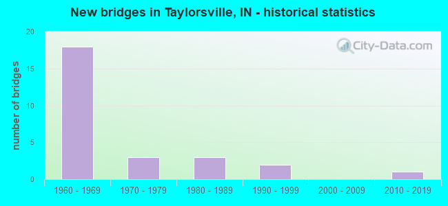
- New bridges - historical statistics
- 181960-1969
- 31970-1979
- 31980-1989
- 21990-1999
- 12010-2019
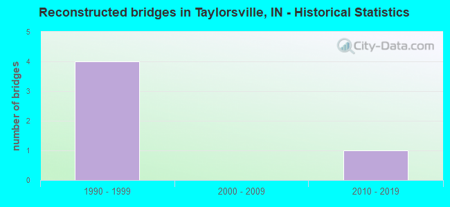
- Reconstructed bridges - Historical Statistics
- 41990-1999
- 02000-2009
- 12010-2019
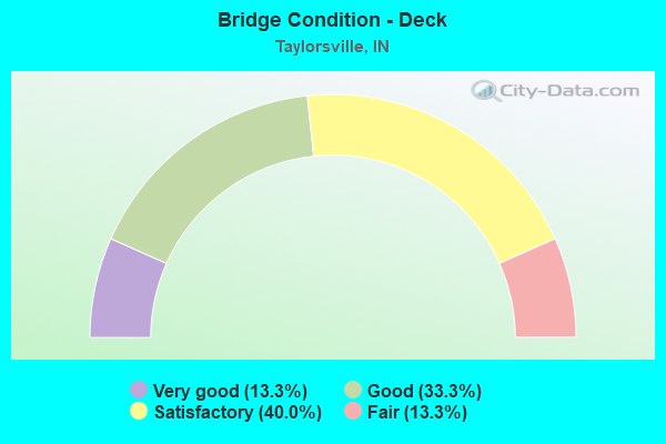
- Bridge Condition - Deck
- 13.3%Very good
- 33.3%Good
- 40.0%Satisfactory
- 13.3%Fair
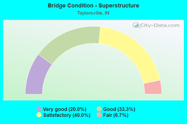
- Bridge Condition - Superstructure
- 20.0%Very good
- 33.3%Good
- 40.0%Satisfactory
- 6.7%Fair
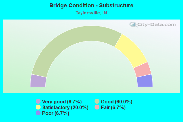
- Bridge Condition - Substructure
- 6.7%Very good
- 60.0%Good
- 20.0%Satisfactory
- 6.7%Fair
- 6.7%Poor
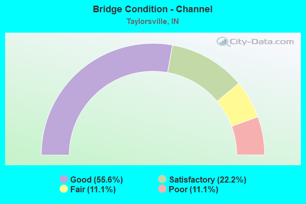
- Bridge Condition - Channel
- 55.6%Good
- 22.2%Satisfactory
- 11.1%Fair
- 11.1%Poor
Find on map >> Show street view
Structure Number: 3558, Location: 02.38 S US 31 (Lat: 39.273611, Lng: -85.953961), Route carried "on" structure: Alternate County highway , Year Built: 1961, Status: Open, Structure Length: 6.58m (21.59ft), Average Daily Traffic: 518 (year 2004), Truck Traffic: 10%, Average Future Daily Traffic: 867 (year 2032), Design Load: HS 20, Features Intersected: I-65, Facility Carried by Structure: CR 500 N
Minimum Vertical Clearance: 30+ m (98+ ft), Kilometerpoint: 0.000, Lanes on structure: 2, Lanes under structure: 5, Owner: State Highway Agency, Approaching Roadway Width: 7.6m (24.9ft), Skew: 1 degrees, Material/Design: Concrete continuous, Design/Construction: Stringer/Multi-beam, Number Of Spans In Main Unit: 4, Length of Maximum Span: 20.7m (67.9ft), Curb or Sidewalk Widths: Left: 0.5m (1.6ft), Right: 0.5m (1.6ft), Curb-To-Curb Width: 5.6m (18.4ft), Out-to-Out Width: 7.1m (23.3ft)
Condition: Deck: Satisfactory, Superstructure: Satisfactory, Substructure: Good, Operating Rating: 54.8 metric tons, Method Used To Determine Operating Rating: Load Factor (LF), Inventory Rating: 32.8 metric tons, Method Used To Determine Inventory Rating: Load Factor (LF), Structural Evaluation: Equal to present minimum criteria, Deck Geometry: High priority of replacement, Underclear: Meets minimum limits, Approach Roadway Alignment: Equal to present desirable criteria, Designated Inspection Frequency: Every 24 months, Inspection Date: December 2020, Deck Structure Type: Concrete Cast-file-Place, Wearing Surface/Protective System: Wearing Surface: Monolithic Concrete
Find on map >> Show street view
Structure Number: 3559, Location: 00.72 S US 31 (Lat: 39.295381, Lng: -85.967100), Route carried "on" structure: Alternate County highway , Year Built: 1961, Status: Open, Structure Length: 6.40m (21.00ft), Average Daily Traffic: 3,309 (year 2004), Truck Traffic: 10%, Average Future Daily Traffic: 5,550 (year 2033), Design Load: HS 20, Features Intersected: I-65, Facility Carried by Structure: CR 650 N/TANNEHILL
Minimum Vertical Clearance: 30+ m (98+ ft), Kilometerpoint: 0.000, Lanes on structure: 2, Lanes under structure: 4, Owner: State Highway Agency, Approaching Roadway Width: 7.3m (24.0ft), Material/Design: Steel continuous, Design/Construction: Stringer/Multi-beam, Number Of Spans In Main Unit: 2, Number Of Approach Spans: 2, Length of Maximum Span: 20.0m (65.6ft), Curb or Sidewalk Widths: Left: 0.5m (1.6ft), Right: 0.5m (1.6ft), Curb-To-Curb Width: 7.3m (24.0ft), Out-to-Out Width: 9.0m (29.5ft)
Condition: Deck: Fair, Superstructure: Satisfactory, Substructure: Satisfactory, Operating Rating: 62.1 metric tons, Method Used To Determine Operating Rating: Load Factor (LF), Inventory Rating: 37.2 metric tons, Method Used To Determine Inventory Rating: Load Factor (LF), Structural Evaluation: Equal to present minimum criteria, Deck Geometry: High priority of replacement, Underclear: Meets minimum limits, Approach Roadway Alignment: Equal to present desirable criteria, Designated Inspection Frequency: Every 24 months, Inspection Date: December 2020, Deck Structure Type: Concrete Cast-file-Place, Wearing Surface/Protective System: Wearing Surface: Monolithic Concrete
Find on map >> Show street view
Structure Number: 356, Location: 04.32 S SR 252 (Lat: 39.304650, Lng: -85.962319), Route carried "on" structure: Interstate 65, Year Built: 1961, Year Reconstructed: 2016, Status: Open, Structure Length: 7.13m (23.39ft), Average Daily Traffic: 16,984 (year 2004), Truck Traffic: 10%, Average Future Daily Traffic: 32,977 (year 2033), Design Load: HS 20+Mod, Features Intersected: US 31
Minimum Vertical Clearance: 30+ m (98+ ft), Kilometerpoint: 121.892, Lanes on structure: 3, Lanes under structure: 8, Base Highway Network: Yes (, Subroute: 1), Owner: State Highway Agency, Approaching Roadway Width: 15.9m (52.2ft), Skew: 2 degrees, Material/Design: Steel continuous, Design/Construction: Stringer/Multi-beam, Number Of Spans In Main Unit: 4, Length of Maximum Span: 23.5m (77.1ft), Curb-To-Curb Width: 16.3m (53.5ft), Out-to-Out Width: 17.0m (55.8ft)
Condition: Deck: Good, Superstructure: Fair, Substructure: Good, Operating Rating: 48.3 metric tons, Method Used To Determine Operating Rating: Load and Resistance Factor Rating (LRFR) rating reported by rating factor(RF) method using HL-93 loadings, Inventory Rating: 37.3 metric tons, Method Used To Determine Inventory Rating: Load and Resistance Factor Rating (LRFR) rating reported by rating factor(RF) method using HL-93 loadings, Structural Evaluation: Somewhat better than minimum adequacy, Deck Geometry: Equal to present minimum criteria, Underclear: Meets minimum limits, Approach Roadway Alignment: Equal to present desirable criteria, Designated Inspection Frequency: Every 24 months, Inspection Date: December 2020, Deck Structure Type: Concrete Cast-file-Place, Wearing Surface/Protective System: Wearing Surface: Epoxy Overlay, Deck Protection: Epoxy Coated Reinforcing
Find on map >> Show street view
Structure Number: 3561, Location: 04.32 S SR 252 (Lat: 39.304969, Lng: -85.962439), Route carried "on" structure: Interstate 65, Year Built: 1961, Year Reconstructed: 1995, Status: Open, Structure Length: 7.13m (23.39ft), Average Daily Traffic: 16,984 (year 2004), Truck Traffic: 10%, Average Future Daily Traffic: 32,977 (year 2033), Design Load: HS 20+Mod, Features Intersected: US 31
Minimum Vertical Clearance: 30+ m (98+ ft), Kilometerpoint: 121.892, Lanes on structure: 3, Lanes under structure: 8, Base Highway Network: Yes (, Subroute: 1), Owner: State Highway Agency, Approaching Roadway Width: 15.9m (52.2ft), Skew: 2 degrees, Material/Design: Steel continuous, Design/Construction: Stringer/Multi-beam, Number Of Spans In Main Unit: 4, Length of Maximum Span: 23.5m (77.1ft), Curb-To-Curb Width: 16.1m (52.8ft), Out-to-Out Width: 17.0m (55.8ft)
Condition: Deck: Satisfactory, Superstructure: Satisfactory, Substructure: Satisfactory, Operating Rating: 48.3 metric tons, Method Used To Determine Operating Rating: Load and Resistance Factor Rating (LRFR) rating reported by rating factor(RF) method using HL-93 loadings, Inventory Rating: 37.3 metric tons, Method Used To Determine Inventory Rating: Load and Resistance Factor Rating (LRFR) rating reported by rating factor(RF) method using HL-93 loadings, Structural Evaluation: Equal to present minimum criteria, Deck Geometry: Equal to present minimum criteria, Underclear: Meets minimum limits, Approach Roadway Alignment: Equal to present desirable criteria, Designated Inspection Frequency: Every 24 months, Inspection Date: December 2020, Deck Structure Type: Concrete Cast-file-Place, Wearing Surface/Protective System: Wearing Surface: Epoxy Overlay, Deck Protection: Epoxy Coated Reinforcing
Find on map >> Show street view
Structure Number: 3562, Location: 00.66 N US 31 (Lat: 39.311889, Lng: -85.954411), Route carried "on" structure: Interstate 65, Year Built: 1968, Year Reconstructed: 1997, Status: Open, Structure Length: 5.82m (19.09ft), Average Daily Traffic: 19,295 (year 2004), Truck Traffic: 10%, Average Future Daily Traffic: 37,093 (year 2032), Design Load: HS 20+Mod, Features Intersected: LOUISVILLE & INDIANA RR
Minimum Vertical Clearance: 30+ m (98+ ft), Kilometerpoint: 122.954, Lanes on structure: 2, Base Highway Network: Yes (, Subroute: 1), Owner: State Highway Agency, Approaching Roadway Width: 12.2m (40.0ft), Skew: 4 degrees, Material/Design: Steel continuous, Design/Construction: Stringer/Multi-beam, Number Of Spans In Main Unit: 3, Length of Maximum Span: 22.1m (72.5ft), Curb-To-Curb Width: 12.1m (39.7ft), Out-to-Out Width: 13.0m (42.7ft)
Condition: Deck: Good, Superstructure: Very good, Substructure: Good, Operating Rating: 46.3 metric tons, Method Used To Determine Operating Rating: Load and Resistance Factor Rating (LRFR) rating reported by rating factor(RF) method using HL-93 loadings, Inventory Rating: 35.6 metric tons, Method Used To Determine Inventory Rating: Load and Resistance Factor Rating (LRFR) rating reported by rating factor(RF) method using HL-93 loadings, Structural Evaluation: Better than present minimum criteria, Deck Geometry: Equal to present minimum criteria, Underclear: Better than present minimum criteria, Approach Roadway Alignment: Equal to present desirable criteria, Designated Inspection Frequency: Every 24 months, Inspection Date: December 2020, Deck Structure Type: Concrete Cast-file-Place, Wearing Surface/Protective System: Wearing Surface: Epoxy Overlay, Deck Protection: Epoxy Coated Reinforcing
Find on map >> Show street view
Structure Number: 3563, Location: 00.66 N US 31 (Lat: 39.312239, Lng: -85.954461), Route carried "on" structure: Interstate 65, Year Built: 1968, Year Reconstructed: 1997, Status: Open, Structure Length: 5.82m (19.09ft), Average Daily Traffic: 19,295 (year 2004), Truck Traffic: 10%, Average Future Daily Traffic: 37,093 (year 2032), Design Load: HS 20+Mod, Features Intersected: LOUISVILLE & INDIANA RR
Minimum Vertical Clearance: 30+ m (98+ ft), Kilometerpoint: 122.954, Lanes on structure: 2, Base Highway Network: Yes (, Subroute: 1), Owner: State Highway Agency, Approaching Roadway Width: 12.2m (40.0ft), Skew: 4 degrees, Material/Design: Steel continuous, Design/Construction: Stringer/Multi-beam, Number Of Spans In Main Unit: 3, Length of Maximum Span: 22.1m (72.5ft), Curb-To-Curb Width: 12.1m (39.7ft), Out-to-Out Width: 13.0m (42.7ft)
Condition: Deck: Very good, Superstructure: Very good, Substructure: Good, Operating Rating: 46.3 metric tons, Method Used To Determine Operating Rating: Load and Resistance Factor Rating (LRFR) rating reported by rating factor(RF) method using HL-93 loadings, Inventory Rating: 35.6 metric tons, Method Used To Determine Inventory Rating: Load and Resistance Factor Rating (LRFR) rating reported by rating factor(RF) method using HL-93 loadings, Structural Evaluation: Better than present minimum criteria, Deck Geometry: Equal to present minimum criteria, Underclear: Better than present minimum criteria, Approach Roadway Alignment: Equal to present desirable criteria, Designated Inspection Frequency: Every 24 months, Inspection Date: December 2020, Deck Structure Type: Concrete Cast-file-Place, Wearing Surface/Protective System: Wearing Surface: Epoxy Overlay, Deck Protection: Epoxy Coated Reinforcing
Find on map >> Show street view
Structure Number: 3564, Location: 01.18 N US 31 (Lat: 39.317961, Lng: -85.948439), Route carried "on" structure: County highway , Year Built: 1968, Status: Open, Structure Length: 7.77m (25.49ft), Average Daily Traffic: 682 (year 2004), Truck Traffic: 10%, Average Future Daily Traffic: 1,143 (year 2033), Design Load: HS 20, Features Intersected: I-65, Facility Carried by Structure: CR 800 N
Minimum Vertical Clearance: 30+ m (98+ ft), Kilometerpoint: 0.000, Lanes on structure: 2, Lanes under structure: 4, Owner: State Highway Agency, Approaching Roadway Width: 8.5m (27.9ft), Skew: 2 degrees, Material/Design: Steel continuous, Design/Construction: Stringer/Multi-beam, Number Of Spans In Main Unit: 2, Length of Maximum Span: 38.4m (126.0ft), Curb or Sidewalk Widths: Left: 0.1m (0.3ft), Right: 0.1m (0.3ft), Curb-To-Curb Width: 9.8m (32.2ft), Out-to-Out Width: 10.7m (35.1ft)
Condition: Deck: Satisfactory, Superstructure: Good, Substructure: Good, Operating Rating: 37.6 metric tons, Method Used To Determine Operating Rating: Load and Resistance Factor Rating (LRFR) rating reported by rating factor(RF) method using HL-93 loadings, Inventory Rating: 28.8 metric tons, Method Used To Determine Inventory Rating: Load and Resistance Factor Rating (LRFR) rating reported by rating factor(RF) method using HL-93 loadings, Structural Evaluation: Better than present minimum criteria, Deck Geometry: Equal to present minimum criteria, Underclear: Somewhat better than minimum adequacy, Approach Roadway Alignment: Equal to present desirable criteria, Designated Inspection Frequency: Every 24 months, Inspection Date: December 2020, Deck Structure Type: Concrete Cast-file-Place, Wearing Surface/Protective System: Wearing Surface: Monolithic Concrete
Find on map >> Show street view
Structure Number: 3664, Location: 02.26 N I-70 (Lat: 39.785469, Lng: -86.142731), Route carried "on" structure: Ramp Interstate 65, Year Built: 1974, Year Reconstructed: 2003, Status: Open, Structure Length: 6.69m (21.95ft), Average Daily Traffic: 46,862 (year 2004), Truck Traffic: 5%, Average Future Daily Traffic: 93,349 (year 2030), Design Load: HS 20+Mod, Features Intersected: PROPOSED RAMP
Minimum Vertical Clearance: 30+ m (98+ ft), Kilometerpoint: 180.826, Lanes on structure: 2, Base Highway Network: Yes (, Subroute: 1), Owner: State Highway Agency, Approaching Roadway Width: 12.2m (40.0ft), Skew: 9 degrees, Material/Design: Steel continuous, Design/Construction: Stringer/Multi-beam, Number Of Spans In Main Unit: 3, Length of Maximum Span: 25.3m (83.0ft), Curb-To-Curb Width: 12.0m (39.4ft), Out-to-Out Width: 13.0m (42.7ft)
Condition: Deck: Fair, Superstructure: Good, Substructure: Good, Operating Rating: 43.1 metric tons, Method Used To Determine Operating Rating: Load and Resistance Factor Rating (LRFR) rating reported by rating factor(RF) method using HL-93 loadings, Inventory Rating: 33.4 metric tons, Method Used To Determine Inventory Rating: Load and Resistance Factor Rating (LRFR) rating reported by rating factor(RF) method using HL-93 loadings, Structural Evaluation: Better than present minimum criteria, Deck Geometry: Superior to present desirable criteria, Approach Roadway Alignment: Equal to present desirable criteria, Length Of Structure Improvement: 6.71m (22.01ft), Designated Inspection Frequency: Every 24 months, Inspection Date: October 2021, Bridge Improvement Cost: $705,000, Total Project Cost: $705,000, Deck Structure Type: Concrete Cast-file-Place, Wearing Surface/Protective System: Wearing Surface: Latex Concrete
Find on map >> Show street view
Structure Number: 300127, Location: 00.18 W OF CR 100 W (Lat: 39.318081, Lng: -85.936914), Route carried "on" structure: County highway 66, Year Built: 1974, Status: Open, Structure Length: 0.82m (2.69ft), Average Daily Traffic: 860 (year 2018), Truck Traffic: 3%, Average Future Daily Traffic: 1,500 (year 2038), Features Intersected: BIG SLOUGH, Facility Carried by Structure: CR 800N
Minimum Vertical Clearance: 30+ m (98+ ft), Kilometerpoint: 0.000, Lanes on structure: 2, Owner: County Highway Agency, Approaching Roadway Width: 5.6m (18.4ft), Material/Design: Steel, Design/Construction: Culvert, Number Of Spans In Main Unit: 3, Length of Maximum Span: 2.4m (7.9ft), Curb-To-Curb Width: 5.6m (18.4ft), Out-to-Out Width: 5.6m (18.4ft)
Condition: Channel: Satisfactory, Culverts: Satisfactory, Operating Rating: 32.7 metric tons, Method Used To Determine Operating Rating: Field evaluation and documented engineering judgment, Inventory Rating: 32.7 metric tons, Method Used To Determine Inventory Rating: Field evaluation and documented engineering judgment, Structural Evaluation: Equal to present minimum criteria, Deck Geometry: High priority of replacement, Waterway Adequacy: Equal to present minimum criteria, Approach Roadway Alignment: Equal to present desirable criteria, Designated Inspection Frequency: Every 24 months, Inspection Date: May 2020
Find on map >> Show street view
Structure Number: 300128, Location: 00.07 E OF US 31 (Lat: 39.273781, Lng: -85.944472), Route carried "on" structure: Alternate County highway 210, Year Built: 1981, Status: Open, Structure Length: 1.83m (6.00ft), Average Daily Traffic: 160 (year 2018), Truck Traffic: 5%, Average Future Daily Traffic: 280 (year 2038), Design Load: HS 20, Features Intersected: BIG SLOUGH, Facility Carried by Structure: CR 500N
Minimum Vertical Clearance: 30+ m (98+ ft), Kilometerpoint: 0.000, Lanes on structure: 2, Owner: County Highway Agency, Approaching Roadway Width: 6.7m (22.0ft), Skew: 1 degrees, Material/Design: Prestressed concrete, Design/Construction: Box Beam or Girders - Multiple, Number Of Spans In Main Unit: 3, Length of Maximum Span: 6.1m (20.0ft), Curb-To-Curb Width: 9.1m (29.9ft), Out-to-Out Width: 9.2m (30.2ft)
Condition: Deck: Satisfactory, Superstructure: Satisfactory, Substructure: Satisfactory, Channel: Good, Operating Rating: 69.8 metric tons, Method Used To Determine Operating Rating: Load and Resistance Factor (LRFR), Inventory Rating: 41.8 metric tons, Method Used To Determine Inventory Rating: Load and Resistance Factor (LRFR), Structural Evaluation: Equal to present minimum criteria, Deck Geometry: Equal to present minimum criteria, Waterway Adequacy: Better than present minimum criteria, Approach Roadway Alignment: Equal to present desirable criteria, Designated Inspection Frequency: Every 24 months, Inspection Date: May 2020, Deck Structure Type: Concrete Precast Panels, Wearing Surface/Protective System: Wearing Surface: Bituminous
Find on map >> Show street view
Structure Number: 300129, Location: 00.34 E OF US 31 (Lat: 39.281219, Lng: -85.941117), Route carried "on" structure: County highway 52, Year Built: 1983, Status: Posted for load, Structure Length: 1.46m (4.79ft), Average Daily Traffic: 7,220 (year 2018), Truck Traffic: 5%, Average Future Daily Traffic: 12,570 (year 2038), Design Load: HS 20, Features Intersected: BIG SLOUGH, Facility Carried by Structure: CR 550N
Minimum Vertical Clearance: 30+ m (98+ ft), Kilometerpoint: 0.000, Lanes on structure: 2, Owner: County Highway Agency, Approaching Roadway Width: 6.9m (22.6ft), Material/Design: Prestressed concrete continuous, Design/Construction: Stringer/Multi-beam, Number Of Spans In Main Unit: 1, Length of Maximum Span: 13.9m (45.6ft), Curb-To-Curb Width: 9.8m (32.2ft), Out-to-Out Width: 10.4m (34.1ft)
Condition: Deck: Good, Superstructure: Good, Substructure: Good, Channel: Satisfactory, Operating Rating: 31.3 metric tons, Method Used To Determine Operating Rating: Load and Resistance Factor (LRFR), Inventory Rating: 3.3 metric tons, Method Used To Determine Inventory Rating: Load and Resistance Factor (LRFR), Structural Evaluation: High priority of corrective action, Deck Geometry: Meets minimum limits, Waterway Adequacy: Better than present minimum criteria, Approach Roadway Alignment: Equal to present desirable criteria, Bridge Posting: Required (Relationship of Operating Rating to Maximum Legal Load: 0.1 - 9.9% below), Designated Inspection Frequency: Every 24 months, Inspection Date: May 2020, Deck Structure Type: Concrete Cast-file-Place, Wearing Surface/Protective System: Wearing Surface: Monolithic Concrete
Find on map >> Show street view
Structure Number: 300131, Location: 00.42 W OF CR 100 W (Lat: 39.303339, Lng: -85.940689), Route carried "on" structure: Alternate County highway 62, Year Built: 1989, Status: Open, Structure Length: 1.31m (4.30ft), Average Daily Traffic: 390 (year 2018), Truck Traffic: 5%, Average Future Daily Traffic: 680 (year 2038), Design Load: HS 20, Features Intersected: BIG SLOUGH, Facility Carried by Structure: CR 700N
Minimum Vertical Clearance: 30+ m (98+ ft), Kilometerpoint: 0.000, Lanes on structure: 2, Owner: County Highway Agency, Approaching Roadway Width: 4.9m (16.1ft), Skew: 2 degrees, Material/Design: Steel, Design/Construction: Culvert, Number Of Spans In Main Unit: 3, Length of Maximum Span: 4.3m (14.1ft), Curb-To-Curb Width: 5.5m (18.0ft), Out-to-Out Width: 5.5m (18.0ft)
Condition: Channel: Good, Culverts: Satisfactory, Operating Rating: 32.7 metric tons, Method Used To Determine Operating Rating: Field evaluation and documented engineering judgment, Inventory Rating: 32.7 metric tons, Method Used To Determine Inventory Rating: Field evaluation and documented engineering judgment, Structural Evaluation: Equal to present minimum criteria, Deck Geometry: High priority of corrective action, Waterway Adequacy: Better than present minimum criteria, Approach Roadway Alignment: Equal to present minimum criteria, Designated Inspection Frequency: Every 24 months, Inspection Date: May 2020
Find on map >> Show street view
Structure Number: 300133, Location: 01.14 W OF US 31 (Lat: 39.290481, Lng: -85.972769), Route carried "on" structure: County highway 60, Year Built: 1966, Status: Posted for load, Structure Length: 7.10m (23.29ft), Average Daily Traffic: 1,860 (year 2018), Truck Traffic: 5%, Average Future Daily Traffic: 3,240 (year 2038), Design Load: HS 20, Features Intersected: DRIFTWOOD RIVER, Facility Carried by Structure: TANNEHILL RD
Minimum Vertical Clearance: 30+ m (98+ ft), Kilometerpoint: 0.000, Lanes on structure: 2, Owner: County Highway Agency, Approaching Roadway Width: 6.1m (20.0ft), Material/Design: Steel continuous, Design/Construction: Stringer/Multi-beam, Number Of Spans In Main Unit: 2, Length of Maximum Span: 34.7m (113.8ft), Curb or Sidewalk Widths: Left: 0.3m (1.0ft), Right: 0.3m (1.0ft), Curb-To-Curb Width: 6.7m (22.0ft), Out-to-Out Width: 7.3m (24.0ft)
Condition: Deck: Satisfactory, Superstructure: Satisfactory, Substructure: Poor, Channel: Fair, Operating Rating: 32.7 metric tons, Method Used To Determine Operating Rating: Field evaluation and documented engineering judgment, Inventory Rating: 16.9 metric tons, Method Used To Determine Inventory Rating: Field evaluation and documented engineering judgment, Structural Evaluation: Meets minimum limits, Deck Geometry: High priority of corrective action, Waterway Adequacy: Better than present minimum criteria, Approach Roadway Alignment: Equal to present minimum criteria, Length Of Structure Improvement: 7.10m (23.29ft), Designated Inspection Frequency: Every 12 months, Inspection Date: May 2021, Bridge Improvement Cost: $30,000, Total Project Cost: $30,000 ( Estimate for 2020), Deck Structure Type: Concrete Cast-file-Place, Wearing Surface/Protective System: Wearing Surface: Monolithic Concrete
Find on map >> Show street view
Structure Number: 300134, Location: 00.25 S OF CR 700 N (Lat: 39.298861, Lng: -85.984100), Route carried "on" structure: Alternate County highway 309, Year Built: 1995, Status: Open, Structure Length: 1.52m (4.99ft), Average Daily Traffic: 280 (year 2018), Truck Traffic: 5%, Average Future Daily Traffic: 490 (year 2038), Design Load: HS 20, Features Intersected: LICK CREEK, Facility Carried by Structure: CR 375W
Minimum Vertical Clearance: 30+ m (98+ ft), Kilometerpoint: 0.000, Lanes on structure: 2, Owner: County Highway Agency, Approaching Roadway Width: 6.4m (21.0ft), Material/Design: Wood or Timber, Design/Construction: Slab, Number Of Spans In Main Unit: 3, Length of Maximum Span: 7.9m (25.9ft), Curb or Sidewalk Widths: Left: 0.2m (0.7ft), Right: 0.2m (0.7ft), Curb-To-Curb Width: 7.4m (24.3ft), Out-to-Out Width: 7.7m (25.3ft)
Condition: Deck: Good, Superstructure: Good, Substructure: Good, Channel: Good, Operating Rating: 57.3 metric tons, Method Used To Determine Operating Rating: Load and Resistance Factor (LRFR), Inventory Rating: 42.5 metric tons, Method Used To Determine Inventory Rating: Load and Resistance Factor (LRFR), Structural Evaluation: Better than present minimum criteria, Deck Geometry: Somewhat better than minimum adequacy, Waterway Adequacy: Equal to present desirable criteria, Approach Roadway Alignment: Equal to present desirable criteria, Designated Inspection Frequency: Every 24 months, Inspection Date: May 2020, Deck Structure Type: Wood or Timber, Wearing Surface/Protective System: Wearing Surface: Bituminous
Find on map >> Show street view
Structure Number: 300135, Location: 00.07 E OF CR 400 W (Lat: 39.295061, Lng: -85.988472), Route carried "on" structure: Alternate County highway 7, Year Built: 1997, Status: Open, Structure Length: 2.29m (7.51ft), Average Daily Traffic: 160 (year 2018), Truck Traffic: 3%, Average Future Daily Traffic: 280 (year 2038), Design Load: HS 20, Features Intersected: LICK CREEK, Facility Carried by Structure: CR 660N
Minimum Vertical Clearance: 30+ m (98+ ft), Kilometerpoint: 0.000, Lanes on structure: 2, Owner: County Highway Agency, Approaching Roadway Width: 5.2m (17.1ft), Skew: 2 degrees, Material/Design: Prestressed concrete, Design/Construction: Box Beam or Girders - Multiple, Number Of Spans In Main Unit: 3, Length of Maximum Span: 11.3m (37.1ft), Curb-To-Curb Width: 7.9m (25.9ft), Out-to-Out Width: 8.0m (26.2ft)
Condition: Deck: Satisfactory, Superstructure: Satisfactory, Substructure: Good, Channel: Good, Operating Rating: 32.7 metric tons, Method Used To Determine Operating Rating: Field evaluation and documented engineering judgment, Inventory Rating: 32.7 metric tons, Method Used To Determine Inventory Rating: Field evaluation and documented engineering judgment, Structural Evaluation: Equal to present minimum criteria, Deck Geometry: Somewhat better than minimum adequacy, Waterway Adequacy: Equal to present minimum criteria, Approach Roadway Alignment: Equal to present minimum criteria, Designated Inspection Frequency: Every 24 months, Inspection Date: May 2020, Deck Structure Type: Concrete Precast Panels, Wearing Surface/Protective System: Wearing Surface: Bituminous
Find on map >> Show street view
Structure Number: 300219, Location: 00.36 E OF CR 50 W (Lat: 39.318439, Lng: -85.916947), Route carried "on" structure: County highway 66, Year Built: 1979, Status: Open, Structure Length: 0.82m (2.69ft), Average Daily Traffic: 960 (year 2018), Truck Traffic: 5%, Average Future Daily Traffic: 1,670 (year 2038), Design Load: HS 20, Features Intersected: BRANCH OF BIG SLOUGH, Facility Carried by Structure: CR 800N
Minimum Vertical Clearance: 30+ m (98+ ft), Kilometerpoint: 0.000, Lanes on structure: 2, Owner: County Highway Agency, Approaching Roadway Width: 6.7m (22.0ft), Skew: 2 degrees, Material/Design: Prestressed concrete, Design/Construction: Box Beam or Girders - Multiple, Number Of Spans In Main Unit: 1, Length of Maximum Span: 6.9m (22.6ft), Curb-To-Curb Width: 7.9m (25.9ft), Out-to-Out Width: 8.1m (26.6ft)
Condition: Deck: Good, Superstructure: Good, Substructure: Fair, Channel: Poor, Operating Rating: 61.6 metric tons, Method Used To Determine Operating Rating: Load and Resistance Factor (LRFR), Inventory Rating: 35.1 metric tons, Method Used To Determine Inventory Rating: Load and Resistance Factor (LRFR), Structural Evaluation: Somewhat better than minimum adequacy, Deck Geometry: Somewhat better than minimum adequacy, Waterway Adequacy: Meets minimum limits, Approach Roadway Alignment: Equal to present desirable criteria, Length Of Structure Improvement: 0.82m (2.69ft), Designated Inspection Frequency: Every 24 months, Inspection Date: May 2020, Bridge Improvement Cost: $30,000, Total Project Cost: $30,000 ( Estimate for 2020), Deck Structure Type: Concrete Precast Panels, Wearing Surface/Protective System: Wearing Surface: Bituminous
Find on map >> Show street view
Structure Number: 300328, Location: 00.70 E OF US 31 (Lat: 39.295931, Lng: -85.943642), Route carried "on" structure: Alternate County highway 600, Year Built: 2013, Status: Open, Structure Length: 3.53m (11.58ft), Average Daily Traffic: 1,400 (year 2018), Truck Traffic: 5%, Average Future Daily Traffic: 2,440 (year 2038), Design Load: HL 93, Features Intersected: BIG SLOUGH, Facility Carried by Structure: CR 650N
Minimum Vertical Clearance: 30+ m (98+ ft), Kilometerpoint: 0.000, Lanes on structure: 2, Owner: County Highway Agency, Approaching Roadway Width: 7.3m (24.0ft), Material/Design: Concrete continuous, Design/Construction: Slab, Number Of Spans In Main Unit: 3, Length of Maximum Span: 13.4m (44.0ft), Curb-To-Curb Width: 9.1m (29.9ft), Out-to-Out Width: 9.3m (30.5ft)
Condition: Deck: Very good, Superstructure: Very good, Substructure: Very good, Channel: Good, Operating Rating: 51.0 metric tons, Method Used To Determine Operating Rating: Load and Resistance Factor (LRFR), Inventory Rating: 42.3 metric tons, Method Used To Determine Inventory Rating: Load and Resistance Factor (LRFR), Structural Evaluation: Equal to present desirable criteria, Deck Geometry: Somewhat better than minimum adequacy, Waterway Adequacy: Equal to present minimum criteria, Approach Roadway Alignment: Equal to present desirable criteria, Designated Inspection Frequency: Every 24 months, Inspection Date: May 2020, Deck Structure Type: Concrete Cast-file-Place, Wearing Surface/Protective System: Wearing Surface: Monolithic Concrete, Deck Protection: Epoxy Coated Reinforcing
Find on map >> Show street view
Structure Number: 3558, Location: 02.38 S US 31 (Lat: 39.273611, Lng: -85.953964), Route carried "under" structure: Interstate 65, Year Built: 1961, Structure Length: 0. m, Average Daily Traffic: 20,946 (year 2004), Truck Traffic: 5%, Features Intersected: I-65 NB, Facility Carried by Structure: CR 500 N
Minimum Vertical Clearance: 5.36m (17.59ft), Kilometerpoint: 118.061, Lanes on structure: 2, Lanes under structure: 5, Material/Design: Concrete continuous, Design/Construction: Stringer/Multi-beam, Length of Maximum Span: 20.7m (67.9ft)
Find on map >> Show street view
Structure Number: 3558, Location: 02.38 S US 31 (Lat: 39.273611, Lng: -85.953964), Route carried "under" structure: Interstate 65, Year Built: 1961, Structure Length: 0. m, Average Daily Traffic: 19,295 (year 2004), Truck Traffic: 10%, Features Intersected: I-65 SB, Facility Carried by Structure: CR 500N
Minimum Vertical Clearance: 5.03m (16.50ft), Kilometerpoint: 118.061, Lanes on structure: 2, Lanes under structure: 5, Material/Design: Concrete continuous, Design/Construction: Stringer/Multi-beam, Length of Maximum Span: 20.7m (67.9ft)
Find on map >> Show street view
Structure Number: 3559, Location: 00.72 S US 31 (Lat: 39.295381, Lng: -85.967103), Route carried "under" structure: Interstate 65, Year Built: 1961, Structure Length: 0. m, Average Daily Traffic: 20,946 (year 2004), Truck Traffic: 5%, Features Intersected: I-65 NB
Minimum Vertical Clearance: 4.95m (16.24ft), Kilometerpoint: 120.733, Lanes on structure: 2, Lanes under structure: 4, Material/Design: Steel continuous, Design/Construction: Stringer/Multi-beam, Length of Maximum Span: 20.0m (65.6ft)
Find on map >> Show street view
Structure Number: 3559, Location: 00.72 S US 31 (Lat: 39.295381, Lng: -85.967103), Route carried "under" structure: Interstate 65, Year Built: 1961, Structure Length: 0. m, Average Daily Traffic: 19,295 (year 2004), Truck Traffic: 10%, Features Intersected: I-65 SB
Minimum Vertical Clearance: 4.78m (15.68ft), Kilometerpoint: 120.733, Lanes on structure: 2, Lanes under structure: 4, Material/Design: Steel continuous, Design/Construction: Stringer/Multi-beam, Length of Maximum Span: 20.0m (65.6ft)
Find on map >> Show street view
Structure Number: 356, Location: 04.32 S SR 252 (Lat: 39.304650, Lng: -85.962317), Route carried "under" structure: US 31, Year Built: 1961, Structure Length: 0. m, Average Daily Traffic: 8,387 (year 2004), Truck Traffic: 5%, Features Intersected: US 31 NB, Facility Carried by Structure: I-65 NB
Minimum Vertical Clearance: 4.80m (15.75ft), Kilometerpoint: 31.752, Lanes on structure: 3, Lanes under structure: 8, Material/Design: Steel continuous, Design/Construction: Stringer/Multi-beam, Length of Maximum Span: 23.5m (77.1ft)
Find on map >> Show street view
Structure Number: 356, Location: 04.32 S SR 252 (Lat: 39.304650, Lng: -85.962317), Route carried "under" structure: US 31, Year Built: 1961, Structure Length: 0. m, Average Daily Traffic: 5,396 (year 2004), Truck Traffic: 5%, Features Intersected: US 31 SB, Facility Carried by Structure: I-65 NB
Minimum Vertical Clearance: 4.78m (15.68ft), Kilometerpoint: 31.752, Lanes on structure: 3, Lanes under structure: 8, Material/Design: Steel continuous, Design/Construction: Stringer/Multi-beam, Length of Maximum Span: 23.5m (77.1ft)
Find on map >> Show street view
Structure Number: 3561, Location: 04.32 S SR 252 (Lat: 39.304969, Lng: -85.962439), Route carried "under" structure: US 31, Year Built: 1961, Structure Length: 0. m, Average Daily Traffic: 8,387 (year 2004), Truck Traffic: 5%, Features Intersected: US 31 NB, Facility Carried by Structure: I-65 SB
Minimum Vertical Clearance: 4.75m (15.58ft), Kilometerpoint: 31.785, Lanes on structure: 3, Lanes under structure: 8, Material/Design: Steel continuous, Design/Construction: Stringer/Multi-beam, Length of Maximum Span: 23.5m (77.1ft)
Find on map >> Show street view
Structure Number: 3561, Location: 04.32 S SR 252 (Lat: 39.304969, Lng: -85.962439), Route carried "under" structure: US 31, Year Built: 1961, Structure Length: 0. m, Average Daily Traffic: 5,396 (year 2004), Truck Traffic: 5%, Features Intersected: US 31 SB, Facility Carried by Structure: I-65 SB
Minimum Vertical Clearance: 4.78m (15.68ft), Kilometerpoint: 31.785, Lanes on structure: 3, Lanes under structure: 8, Material/Design: Steel continuous, Design/Construction: Stringer/Multi-beam, Length of Maximum Span: 23.5m (77.1ft)
Find on map >> Show street view
Structure Number: 3564, Location: 01.18 N US 31 (Lat: 39.317961, Lng: -85.948442), Route carried "under" structure: Interstate 65, Year Built: 1968, Structure Length: 0. m, Average Daily Traffic: 20,374 (year 2004), Truck Traffic: 10%, Features Intersected: I-65 SB, Facility Carried by Structure: CR 800N
Minimum Vertical Clearance: 5.03m (16.50ft), Kilometerpoint: 123.791, Lanes on structure: 2, Lanes under structure: 4, Material/Design: Steel continuous, Design/Construction: Stringer/Multi-beam, Length of Maximum Span: 38.4m (126.0ft)
Find on map >> Show street view
Structure Number: 3564, Location: 01.18 N US 31 (Lat: 39.317961, Lng: -85.948442), Route carried "under" structure: Interstate 65, Year Built: 1968, Structure Length: 0. m, Average Daily Traffic: 16,984 (year 2004), Truck Traffic: 10%, Features Intersected: I-65 NB, Facility Carried by Structure: CR 800N
Minimum Vertical Clearance: 4.98m (16.34ft), Kilometerpoint: 123.791, Lanes on structure: 2, Lanes under structure: 4, Material/Design: Steel continuous, Design/Construction: Stringer/Multi-beam, Length of Maximum Span: 38.4m (126.0ft)