Bridge Statistics for Tehachapi, California (CA)
Condition, Traffic, Stress, Structural Evaluation, Project Costs
- National Bridge Inventory (NBI) Statistics
- 26Number of bridges
- 249ft / 75.9mTotal length
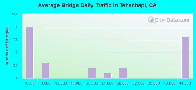
- 483,745Total average daily traffic
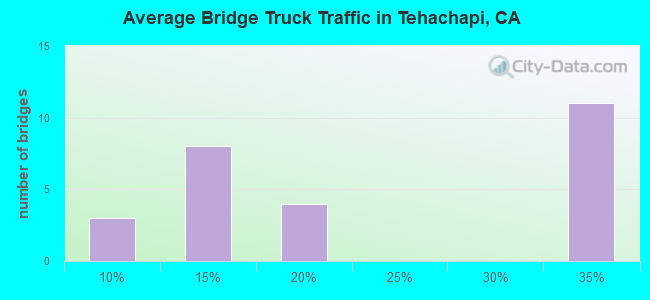
- 133,973Total average daily truck traffic
- National Bridge Inventory (NBI) Registered Bridges for Tehachapi
- No street view available for this location

- New bridges - historical statistics
- 11940-1949
- 11950-1959
- 11960-1969
- 201970-1979
- 11990-1999
- 12000-2009
- 12010-2019
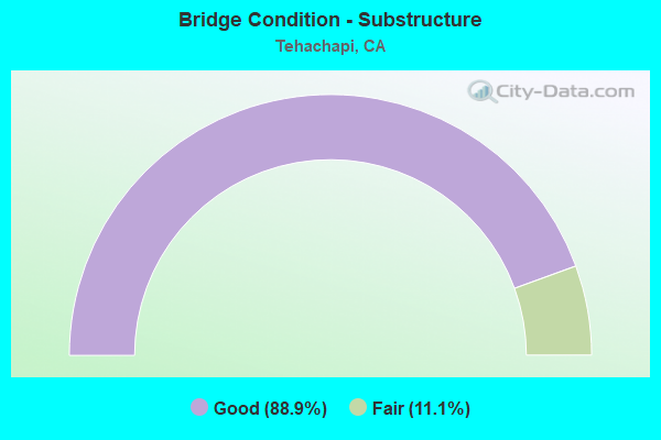
- Bridge Condition - Substructure
- 88.9%Good
- 11.1%Fair
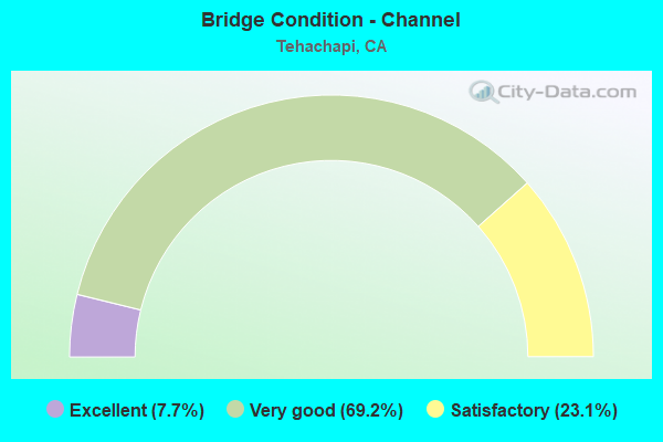
- Bridge Condition - Channel
- 7.7%Excellent
- 69.2%Very good
- 23.1%Satisfactory
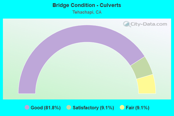
- Bridge Condition - Culverts
- 81.8%Good
- 9.1%Satisfactory
- 9.1%Fair
Find on map >> Show street view
Structure Number: 50 0338, Location: 09-KER-058-R95.21 (Lat: 35.120497, Lng: -118.396564), Route carried "on" structure: County highway W264, Year Built: 1970, Status: Open, Structure Length: 5.79m (19.00ft), Average Daily Traffic: 2,800 (year 2011), Truck Traffic: 10%, Average Future Daily Traffic: 4,118 (year 2040), Design Load: HS 20, Features Intersected: STATE ROUTE 58, Facility Carried by Structure: WILLOW SPRINGS RD
Minimum Vertical Clearance: 30+ m (98+ ft), Kilometerpoint: 0.000, Lanes on structure: 2, Lanes under structure: 4, Owner: State Highway Agency, Approaching Roadway Width: 11.6m (38.1ft), Skew: 1 degrees, Material/Design: Concrete continuous, Design/Construction: Box Beam or Girders - Multiple, Number Of Spans In Main Unit: 2, Length of Maximum Span: 28.7m (94.2ft), Curb-To-Curb Width: 9.8m (32.2ft), Out-to-Out Width: 10.4m (34.1ft)
Condition: Deck: Good, Superstructure: Good, Substructure: Good, Operating Rating: 52.5 metric tons, Method Used To Determine Operating Rating: Load and Resistance Factor Rating (LRFR) rating reported by rating factor(RF) method using HL-93 loadings, Inventory Rating: 38.6 metric tons, Method Used To Determine Inventory Rating: Load and Resistance Factor Rating (LRFR) rating reported by rating factor(RF) method using HL-93 loadings, Structural Evaluation: Better than present minimum criteria, Deck Geometry: Meets minimum limits, Underclear: Equal to present minimum criteria, Approach Roadway Alignment: Equal to present desirable criteria, Designated Inspection Frequency: Every 24 months, Inspection Date: May 2021, Deck Structure Type: Concrete Cast-file-Place, Wearing Surface/Protective System: Wearing Surface: Integral Concrete
Find on map >> Show street view
Structure Number: 50 0339, Location: 09-KER-058-R92.75 (Lat: 35.138903, Lng: -118.432053), Route carried "on" structure: County highway , Year Built: 1970, Status: Open, Structure Length: 5.85m (19.19ft), Average Daily Traffic: 1,020 (year 2011), Truck Traffic: 5%, Average Future Daily Traffic: 1,946 (year 2040), Design Load: HS 20, Features Intersected: STATE ROUTE 58, Facility Carried by Structure: DENNISON ROAD
Minimum Vertical Clearance: 30+ m (98+ ft), Kilometerpoint: 0.000, Lanes on structure: 2, Lanes under structure: 4, Owner: State Highway Agency, Approaching Roadway Width: 11.6m (38.1ft), Skew: 2 degrees, Material/Design: Concrete continuous, Design/Construction: Box Beam or Girders - Multiple, Number Of Spans In Main Unit: 2, Length of Maximum Span: 29.0m (95.1ft), Curb-To-Curb Width: 9.8m (32.2ft), Out-to-Out Width: 10.4m (34.1ft)
Condition: Deck: Good, Superstructure: Good, Substructure: Good, Operating Rating: 43.4 metric tons, Method Used To Determine Operating Rating: Load and Resistance Factor Rating (LRFR) rating reported by rating factor(RF) method using HL-93 loadings, Inventory Rating: 33.7 metric tons, Method Used To Determine Inventory Rating: Load and Resistance Factor Rating (LRFR) rating reported by rating factor(RF) method using HL-93 loadings, Structural Evaluation: Better than present minimum criteria, Deck Geometry: Somewhat better than minimum adequacy, Underclear: Somewhat better than minimum adequacy, Approach Roadway Alignment: Equal to present desirable criteria, Designated Inspection Frequency: Every 24 months, Inspection Date: May 2021, Deck Structure Type: Concrete Cast-file-Place
Find on map >> Show street view
Structure Number: 50 0342, Location: 09-KER-202-11.99 (Lat: 35.141147, Lng: -118.467475), Route carried "on" structure: State highway 202, Year Built: 1970, Status: Open, Structure Length: 6.22m (20.41ft), Average Daily Traffic: 25,400 (year 2011), Truck Traffic: 10%, Average Future Daily Traffic: 36,707 (year 2040), Design Load: HS 20, Features Intersected: STATE ROUTE 58
Minimum Vertical Clearance: 30+ m (98+ ft), Kilometerpoint: 11.990, Lanes on structure: 2, Lanes under structure: 4, Base Highway Network: Yes, Owner: State Highway Agency, Approaching Roadway Width: 12.2m (40.0ft), Material/Design: Concrete continuous, Design/Construction: Box Beam or Girders - Multiple, Number Of Spans In Main Unit: 2, Length of Maximum Span: 35.7m (117.1ft), Curb-To-Curb Width: 12.2m (40.0ft), Out-to-Out Width: 12.8m (42.0ft)
Condition: Deck: Good, Superstructure: Good, Substructure: Fair, Operating Rating: 57.7 metric tons, Method Used To Determine Operating Rating: Load and Resistance Factor Rating (LRFR) rating reported by rating factor(RF) method using HL-93 loadings, Inventory Rating: 44.7 metric tons, Method Used To Determine Inventory Rating: Load and Resistance Factor Rating (LRFR) rating reported by rating factor(RF) method using HL-93 loadings, Structural Evaluation: Somewhat better than minimum adequacy, Deck Geometry: Somewhat better than minimum adequacy, Underclear: High priority of corrective action, Approach Roadway Alignment: Equal to present desirable criteria, Designated Inspection Frequency: Every 24 months, Inspection Date: June 2021, Deck Structure Type: Concrete Cast-file-Place
Find on map >> Show street view
Structure Number: 50 0343L, Location: 09-KER-058-R94.16 (Lat: 35.127747, Lng: -118.411358), Route carried "on" structure: State highway 58, Year Built: 1970, Status: Open, Structure Length: 7.47m (24.51ft), Average Daily Traffic: 19,500 (year 2011), Truck Traffic: 33%, Average Future Daily Traffic: 28,550 (year 2040), Design Load: HS 20+Mod, Features Intersected: UP RR,BNSF,TEHACHAPI BL
Minimum Vertical Clearance: 30+ m (98+ ft), Kilometerpoint: 94.160, Lanes on structure: 3, Lanes under structure: 2, Base Highway Network: Yes (, Subroute: 1), Owner: State Highway Agency, Approaching Roadway Width: 15.2m (49.9ft), Skew: 2 degrees, Material/Design: Concrete continuous, Design/Construction: Box Beam or Girders - Multiple, Number Of Spans In Main Unit: 4, Length of Maximum Span: 23.5m (77.1ft), Curb-To-Curb Width: 15.2m (49.9ft), Out-to-Out Width: 15.8m (51.8ft)
Condition: Deck: Good, Superstructure: Good, Substructure: Good, Operating Rating: 35.0 metric tons, Method Used To Determine Operating Rating: Load and Resistance Factor Rating (LRFR) rating reported by rating factor(RF) method using HL-93 loadings, Inventory Rating: 26.9 metric tons, Method Used To Determine Inventory Rating: Load and Resistance Factor Rating (LRFR) rating reported by rating factor(RF) method using HL-93 loadings, Structural Evaluation: Equal to present minimum criteria, Deck Geometry: Equal to present minimum criteria, Underclear: Equal to present minimum criteria, Approach Roadway Alignment: Equal to present desirable criteria, Designated Inspection Frequency: Every 24 months, Inspection Date: May 2021, Deck Structure Type: Concrete Cast-file-Place, Wearing Surface/Protective System: Wearing Surface: Integral Concrete
Find on map >> Show street view
Structure Number: 50 0343R, Location: 09-KER-058-R94.16 (Lat: 35.127803, Lng: -118.411653), Route carried "on" structure: State highway 58, Year Built: 1970, Status: Open, Structure Length: 7.47m (24.51ft), Average Daily Traffic: 19,500 (year 2011), Truck Traffic: 30%, Average Future Daily Traffic: 28,177 (year 2040), Design Load: HS 20+Mod, Features Intersected: UP RR,BNSF,TEHACHAPI BL
Minimum Vertical Clearance: 30+ m (98+ ft), Kilometerpoint: 94.160, Lanes on structure: 3, Lanes under structure: 2, Base Highway Network: Yes (, Subroute: 1), Owner: State Highway Agency, Approaching Roadway Width: 12.2m (40.0ft), Skew: 2 degrees, Material/Design: Concrete continuous, Design/Construction: Box Beam or Girders - Multiple, Number Of Spans In Main Unit: 4, Length of Maximum Span: 23.5m (77.1ft), Curb-To-Curb Width: 12.2m (40.0ft), Out-to-Out Width: 12.8m (42.0ft)
Condition: Deck: Good, Superstructure: Good, Substructure: Good, Operating Rating: 48.6 metric tons, Method Used To Determine Operating Rating: Load and Resistance Factor Rating (LRFR) rating reported by rating factor(RF) method using HL-93 loadings, Inventory Rating: 37.6 metric tons, Method Used To Determine Inventory Rating: Load and Resistance Factor Rating (LRFR) rating reported by rating factor(RF) method using HL-93 loadings, Structural Evaluation: Better than present minimum criteria, Deck Geometry: Meets minimum limits, Underclear: Equal to present minimum criteria, Approach Roadway Alignment: Equal to present desirable criteria, Designated Inspection Frequency: Every 24 months, Inspection Date: May 2021, Deck Structure Type: Concrete Cast-file-Place, Wearing Surface/Protective System: Wearing Surface: Integral Concrete
Find on map >> Show street view
Structure Number: 50 035, Location: 06-KER-099-R41.16 (Lat: 35.558425, Lng: -119.197694), Route carried "on" structure: County highway W258, Year Built: 1968, Status: Open, Structure Length: 7.80m (25.59ft), Average Daily Traffic: 6,000 (year 2018), Truck Traffic: 15%, Average Future Daily Traffic: 6,500 (year 2039), Design Load: HS 20+Mod, Features Intersected: STATE ROUTE 99, Facility Carried by Structure: KIMBERLINA RD
Minimum Vertical Clearance: 30+ m (98+ ft), Kilometerpoint: 0.000, Lanes on structure: 2, Lanes under structure: 7, Owner: State Highway Agency, Approaching Roadway Width: 12.2m (40.0ft), Skew: 1 degrees, Material/Design: Prestressed concrete continuous, Design/Construction: Stringer/Multi-beam, Number Of Spans In Main Unit: 2, Length of Maximum Span: 39.0m (128.0ft), Curb-To-Curb Width: 12.2m (40.0ft), Out-to-Out Width: 12.8m (42.0ft)
Condition: Deck: Good, Superstructure: Good, Substructure: Good, Operating Rating: 50.5 metric tons, Method Used To Determine Operating Rating: Load and Resistance Factor Rating (LRFR) rating reported by rating factor(RF) method using HL-93 loadings, Inventory Rating: 20.7 metric tons, Method Used To Determine Inventory Rating: Load and Resistance Factor Rating (LRFR) rating reported by rating factor(RF) method using HL-93 loadings, Structural Evaluation: Somewhat better than minimum adequacy, Deck Geometry: Somewhat better than minimum adequacy, Underclear: Equal to present minimum criteria, Approach Roadway Alignment: Better than present minimum criteria, Designated Inspection Frequency: Every 24 months, Inspection Date: October 2021, Deck Structure Type: Concrete Cast-file-Place
Find on map >> Show street view
Structure Number: 50 0355, Location: 09-KER-058-R91.67-THPI (Lat: 35.139975, Lng: -118.450825), Route carried "on" structure: City street , Year Built: 1970, Status: Open, Structure Length: 5.49m (18.01ft), Average Daily Traffic: 2,068 (year 2011), Truck Traffic: 5%, Average Future Daily Traffic: 3,050 (year 2040), Design Load: HS 20, Features Intersected: STATE ROUTE 58, Facility Carried by Structure: MILL STREET
Minimum Vertical Clearance: 30+ m (98+ ft), Kilometerpoint: 0.000, Lanes on structure: 2, Lanes under structure: 4, Owner: State Highway Agency, Approaching Roadway Width: 12.2m (40.0ft), Material/Design: Concrete continuous, Design/Construction: Box Beam or Girders - Multiple, Number Of Spans In Main Unit: 2, Length of Maximum Span: 27.1m (88.9ft), Curb-To-Curb Width: 12.2m (40.0ft), Out-to-Out Width: 12.8m (42.0ft)
Condition: Deck: Good, Superstructure: Good, Substructure: Good, Operating Rating: 48.3 metric tons, Method Used To Determine Operating Rating: Load and Resistance Factor Rating (LRFR) rating reported by rating factor(RF) method using HL-93 loadings, Inventory Rating: 37.3 metric tons, Method Used To Determine Inventory Rating: Load and Resistance Factor Rating (LRFR) rating reported by rating factor(RF) method using HL-93 loadings, Structural Evaluation: Better than present minimum criteria, Deck Geometry: Equal to present minimum criteria, Underclear: Equal to present minimum criteria, Approach Roadway Alignment: Equal to present desirable criteria, Designated Inspection Frequency: Every 24 months, Inspection Date: May 2021, Deck Structure Type: Concrete Cast-file-Place, Wearing Surface/Protective System: Wearing Surface: Integral Concrete
Find on map >> Show street view
Structure Number: 50 0411, Location: 09-KER-058-R91.46-THPI (Lat: 35.139603, Lng: -118.454856), Route carried "on" structure: State highway 58, Year Built: 1970, Status: Open, Structure Length: 1.52m (4.99ft), Average Daily Traffic: 42,400 (year 2011), Truck Traffic: 30%, Average Future Daily Traffic: 64,322 (year 2040), Features Intersected: MILL STREET DRAIN
Minimum Vertical Clearance: 30+ m (98+ ft), Kilometerpoint: 91.460, Lanes on structure: 6, Base Highway Network: Yes (, Subroute: 1), Owner: State Highway Agency, Approaching Roadway Width: 21.9m (71.9ft), Skew: 3 degrees, Material/Design: Concrete continuous, Design/Construction: Culvert, Number Of Spans In Main Unit: 4, Length of Maximum Span: 3.0m (9.8ft)
Condition: Channel: Very good, Culverts: Good, Operating Rating: 54.1 metric tons, Method Used To Determine Operating Rating: Field evaluation and documented engineering judgment, Inventory Rating: 32.4 metric tons, Method Used To Determine Inventory Rating: Field evaluation and documented engineering judgment, Structural Evaluation: Better than present minimum criteria, Waterway Adequacy: Equal to present desirable criteria, Approach Roadway Alignment: Equal to present desirable criteria, Designated Inspection Frequency: Every 24 months, Inspection Date: May 2021
Find on map >> Show street view
Structure Number: 50 0412Y, Location: 09-KER-058-R91.68-THPI (Lat: 35.141389, Lng: -118.450569), Route carried "on" structure: Ramp State highway 58, Year Built: 1970, Status: Open, Structure Length: 1.31m (4.30ft), Average Daily Traffic: 2,025 (year 2011), Truck Traffic: 10%, Average Future Daily Traffic: 3,130 (year 2040), Features Intersected: MILL STREET DRAIN, Facility Carried by Structure: MILL STREET
Minimum Vertical Clearance: 30+ m (98+ ft), Kilometerpoint: 91.680, Lanes on structure: 4, Base Highway Network: Yes (, Subroute: 1), Owner: State Highway Agency, Approaching Roadway Width: 18.0m (59.1ft), Material/Design: Concrete continuous, Design/Construction: Culvert, Number Of Spans In Main Unit: 4, Length of Maximum Span: 3.0m (9.8ft)
Condition: Channel: Very good, Culverts: Good, Operating Rating: 54.1 metric tons, Method Used To Determine Operating Rating: Field evaluation and documented engineering judgment, Inventory Rating: 32.4 metric tons, Method Used To Determine Inventory Rating: Field evaluation and documented engineering judgment, Structural Evaluation: Better than present minimum criteria, Waterway Adequacy: Equal to present desirable criteria, Approach Roadway Alignment: Equal to present minimum criteria, Length Of Structure Improvement: 1.31m (4.30ft), Designated Inspection Frequency: Every 24 months, Inspection Date: May 2021
Find on map >> Show street view
Structure Number: 50 0413, Location: 09-KER-058-R96.67 (Lat: 35.114947, Lng: -118.371689), Route carried "on" structure: State highway 58, Year Built: 1970, Status: Open, Structure Length: 0.98m (3.22ft), Average Daily Traffic: 40,000 (year 2011), Truck Traffic: 33%, Average Future Daily Traffic: 60,170 (year 2040), Features Intersected: MONOLITH DRAIN #1
Minimum Vertical Clearance: 30+ m (98+ ft), Kilometerpoint: 96.670, Lanes on structure: 4, Base Highway Network: Yes (, Subroute: 1), Owner: State Highway Agency, Approaching Roadway Width: 23.8m (78.1ft), Material/Design: Concrete continuous, Design/Construction: Culvert, Number Of Spans In Main Unit: 3, Length of Maximum Span: 2.7m (8.9ft)
Condition: Channel: Very good, Culverts: Good, Operating Rating: 54.1 metric tons, Method Used To Determine Operating Rating: Field evaluation and documented engineering judgment, Inventory Rating: 32.4 metric tons, Method Used To Determine Inventory Rating: Field evaluation and documented engineering judgment, Structural Evaluation: Better than present minimum criteria, Waterway Adequacy: Better than present minimum criteria, Approach Roadway Alignment: Equal to present desirable criteria, Designated Inspection Frequency: Every 24 months, Inspection Date: May 2021
Find on map >> Show street view
Structure Number: 50 0414, Location: 09-KER-058-R96.73 (Lat: 35.114947, Lng: -118.370722), Route carried "on" structure: State highway 58, Year Built: 1970, Status: Open, Structure Length: 0.98m (3.22ft), Average Daily Traffic: 40,000 (year 2011), Truck Traffic: 33%, Average Future Daily Traffic: 60,170 (year 2040), Features Intersected: MONOLITH DRAIN #2
Minimum Vertical Clearance: 30+ m (98+ ft), Kilometerpoint: 96.730, Lanes on structure: 4, Base Highway Network: Yes (, Subroute: 1), Owner: State Highway Agency, Approaching Roadway Width: 23.8m (78.1ft), Material/Design: Concrete continuous, Design/Construction: Culvert, Number Of Spans In Main Unit: 3, Length of Maximum Span: 2.7m (8.9ft)
Condition: Channel: Very good, Culverts: Good, Operating Rating: 54.1 metric tons, Method Used To Determine Operating Rating: Field evaluation and documented engineering judgment, Inventory Rating: 32.4 metric tons, Method Used To Determine Inventory Rating: Field evaluation and documented engineering judgment, Structural Evaluation: Better than present minimum criteria, Waterway Adequacy: Equal to present desirable criteria, Approach Roadway Alignment: Equal to present desirable criteria, Designated Inspection Frequency: Every 24 months, Inspection Date: May 2021
Find on map >> Show street view
Structure Number: 50 0415, Location: 09-KER-058-R96.79 (Lat: 35.114917, Lng: -118.369700), Route carried "on" structure: State highway 58, Year Built: 1970, Status: Open, Structure Length: 0.98m (3.22ft), Average Daily Traffic: 40,000 (year 2011), Truck Traffic: 33%, Average Future Daily Traffic: 60,170 (year 2040), Features Intersected: MONOLITH DRAIN #3
Minimum Vertical Clearance: 30+ m (98+ ft), Kilometerpoint: 96.790, Lanes on structure: 4, Base Highway Network: Yes (, Subroute: 1), Owner: State Highway Agency, Approaching Roadway Width: 23.8m (78.1ft), Material/Design: Concrete continuous, Design/Construction: Culvert, Number Of Spans In Main Unit: 3, Length of Maximum Span: 2.7m (8.9ft)
Condition: Channel: Very good, Culverts: Good, Operating Rating: 54.1 metric tons, Method Used To Determine Operating Rating: Field evaluation and documented engineering judgment, Inventory Rating: 32.4 metric tons, Method Used To Determine Inventory Rating: Field evaluation and documented engineering judgment, Structural Evaluation: Better than present minimum criteria, Waterway Adequacy: Equal to present desirable criteria, Approach Roadway Alignment: Equal to present desirable criteria, Designated Inspection Frequency: Every 24 months, Inspection Date: May 2021
Find on map >> Show street view
Structure Number: 50 0416, Location: 09-KER-058-R97.46 (Lat: 35.112378, Lng: -118.358436), Route carried "on" structure: State highway 58, Year Built: 1970, Status: Open, Structure Length: 0.98m (3.22ft), Average Daily Traffic: 40,000 (year 2011), Truck Traffic: 33%, Average Future Daily Traffic: 60,170 (year 2040), Features Intersected: SHRUB PEAK DRAIN
Minimum Vertical Clearance: 30+ m (98+ ft), Kilometerpoint: 97.460, Lanes on structure: 4, Base Highway Network: Yes (, Subroute: 1), Owner: State Highway Agency, Approaching Roadway Width: 23.8m (78.1ft), Material/Design: Concrete continuous, Design/Construction: Culvert, Number Of Spans In Main Unit: 3, Length of Maximum Span: 2.7m (8.9ft)
Condition: Channel: Very good, Culverts: Good, Operating Rating: 54.1 metric tons, Method Used To Determine Operating Rating: Field evaluation and documented engineering judgment, Inventory Rating: 32.4 metric tons, Method Used To Determine Inventory Rating: Field evaluation and documented engineering judgment, Structural Evaluation: Better than present minimum criteria, Waterway Adequacy: Equal to present desirable criteria, Approach Roadway Alignment: Equal to present desirable criteria, Designated Inspection Frequency: Every 24 months, Inspection Date: May 2021
Find on map >> Show street view
Structure Number: 50 048, Location: 09-KER-014-62.97 (Lat: 35.671769, Lng: -117.869942), Route carried "on" structure: State highway 14, Year Built: 1994, Status: Open, Structure Length: 1.62m (5.31ft), Average Daily Traffic: 3,100 (year 2014), Truck Traffic: 19%, Average Future Daily Traffic: 11,003 (year 2041), Features Intersected: INDIAN WELLS WASH
Minimum Vertical Clearance: 30+ m (98+ ft), Kilometerpoint: 62.970, Lanes on structure: 4, Base Highway Network: Yes (, Subroute: 1), Owner: State Highway Agency, Approaching Roadway Width: 11.9m (39.0ft), Skew: 20 degrees, Material/Design: Concrete continuous, Design/Construction: Culvert, Number Of Spans In Main Unit: 5, Length of Maximum Span: 3.0m (9.8ft)
Condition: Channel: Excellent, Culverts: Fair, Operating Rating: 54.1 metric tons, Method Used To Determine Operating Rating: Field evaluation and documented engineering judgment, Inventory Rating: 32.4 metric tons, Method Used To Determine Inventory Rating: Field evaluation and documented engineering judgment, Structural Evaluation: Somewhat better than minimum adequacy, Waterway Adequacy: Superior to present desirable criteria, Approach Roadway Alignment: Equal to present desirable criteria, Designated Inspection Frequency: Every 24 months, Inspection Date: April 2021
Find on map >> Show street view
Structure Number: 50 0486, Location: 09-KER-202-R9.59-THPI (Lat: 35.134656, Lng: -118.467111), Route carried "on" structure: State highway 202, Year Built: 2002, Status: Open, Structure Length: 14.70m (48.23ft), Average Daily Traffic: 25,400 (year 2011), Truck Traffic: 10%, Average Future Daily Traffic: 36,707 (year 2040), Design Load: HS 20+Mod, Features Intersected: UP RR,BNSF,TEHACHAPI CRK
Minimum Vertical Clearance: 30+ m (98+ ft), Kilometerpoint: 9.590, Lanes on structure: 2, Base Highway Network: Yes, Owner: State Highway Agency, Approaching Roadway Width: 14.4m (47.2ft), Skew: 3 degrees, Material/Design: Prestressed concrete continuous, Design/Construction: Box Beam or Girders - Multiple, Number Of Spans In Main Unit: 3, Length of Maximum Span: 59.0m (193.6ft), Curb-To-Curb Width: 14.4m (47.2ft), Out-to-Out Width: 15.5m (50.9ft)
Condition: Deck: Good, Superstructure: Good, Substructure: Good, Channel: Very good, Operating Rating: 54.1 metric tons, Method Used To Determine Operating Rating: Assigned rating based on Load Factor Design (LFD) reported in metric tons, Inventory Rating: 32.4 metric tons, Method Used To Determine Inventory Rating: Assigned rating based on Load Factor Design (LFD) reported in metric tons, Structural Evaluation: Better than present minimum criteria, Deck Geometry: Superior to present desirable criteria, Underclear: Equal to present minimum criteria, Waterway Adequacy: Equal to present desirable criteria, Approach Roadway Alignment: Equal to present desirable criteria, Designated Inspection Frequency: Every 24 months, Inspection Date: June 2021, Deck Structure Type: Concrete Cast-file-Place, Wearing Surface/Protective System: Wearing Surface: Monolithic Concrete
Find on map >> Show street view
Structure Number: 50C0091, Location: 0.5 MI EAST OF ZACHARY AV (Lat: 35.790525, Lng: -119.178336), Route carried "on" structure: County highway , Year Built: 1971, Status: Open, Structure Length: 2.61m (8.56ft), Average Daily Traffic: 3,000 (year 2005), Truck Traffic: 10%, Average Future Daily Traffic: 4,204 (year 2037), Design Load: HS 20, Features Intersected: FRIANT-KERN CANAL, Facility Carried by Structure: COUNTY LINE RD
Minimum Vertical Clearance: 30+ m (98+ ft), Kilometerpoint: 0.000, Lanes on structure: 2, Owner: County Highway Agency, Approaching Roadway Width: 8.5m (27.9ft), Material/Design: Prestressed concrete, Design/Construction: Stringer/Multi-beam, Number Of Spans In Main Unit: 1, Length of Maximum Span: 25.3m (83.0ft), Curb-To-Curb Width: 12.2m (40.0ft), Out-to-Out Width: 12.4m (40.7ft)
Condition: Deck: Good, Superstructure: Good, Substructure: Good, Channel: Very good, Operating Rating: 42.1 metric tons, Method Used To Determine Operating Rating: Load and Resistance Factor Rating (LRFR) rating reported by rating factor(RF) method using HL-93 loadings, Inventory Rating: 27.2 metric tons, Method Used To Determine Inventory Rating: Load and Resistance Factor Rating (LRFR) rating reported by rating factor(RF) method using HL-93 loadings, Structural Evaluation: Equal to present minimum criteria, Deck Geometry: Equal to present minimum criteria, Waterway Adequacy: Superior to present desirable criteria, Approach Roadway Alignment: Equal to present desirable criteria, Designated Inspection Frequency: Every 24 months, Inspection Date: March 2020, Deck Structure Type: Concrete Cast-file-Place, Wearing Surface/Protective System: Wearing Surface: Bituminous
Find on map >> Show street view
Structure Number: 50C0097, Location: WEST OF DENNISON (Lat: 35.130161, Lng: -118.432400), Route carried "on" structure: City street , Year Built: 1948, Year Reconstructed: 2016, Status: Open, Structure Length: 1.01m (3.31ft), Average Daily Traffic: 3,706 (year 2011), Truck Traffic: 10%, Average Future Daily Traffic: 6,521 (year 2040), Features Intersected: TEHACHAPI STORM DRAIN, Facility Carried by Structure: TEHACHAPI BLVD
Minimum Vertical Clearance: 30+ m (98+ ft), Kilometerpoint: 0.000, Lanes on structure: 2, Owner: City or Municipal Highway Agency, Approaching Roadway Width: 12.9m (42.3ft), Material/Design: Concrete continuous, Design/Construction: Culvert, Number Of Spans In Main Unit: 3, Length of Maximum Span: 3.0m (9.8ft), Curb-To-Curb Width: 12.9m (42.3ft), Out-to-Out Width: 19.8m (65.0ft)
Condition: Channel: Satisfactory, Culverts: Good, Operating Rating: 54.1 metric tons, Method Used To Determine Operating Rating: Field evaluation and documented engineering judgment, Inventory Rating: 32.4 metric tons, Method Used To Determine Inventory Rating: Field evaluation and documented engineering judgment, Structural Evaluation: Better than present minimum criteria, Deck Geometry: Equal to present minimum criteria, Waterway Adequacy: Better than present minimum criteria, Approach Roadway Alignment: Equal to present desirable criteria, Designated Inspection Frequency: Every 48 months, Inspection Date: November 2019, Deck Structure Type: Concrete Cast-file-Place, Wearing Surface/Protective System: Wearing Surface: Bituminous
Find on map >> Show street view
Structure Number: 50C0135, Location: AT HIGHLINE RD (Lat: 35.109617, Lng: -118.396556), Route carried "on" structure: County highway , Year Built: 1972, Status: Open, Structure Length: 0.68m (2.23ft), Average Daily Traffic: 1,890 (year 2002), Truck Traffic: 10%, Average Future Daily Traffic: 2,627 (year 2043), Features Intersected: HIGHLINE RD CANAL, Facility Carried by Structure: TEHACHAPI WIL SPRG
Minimum Vertical Clearance: 30+ m (98+ ft), Kilometerpoint: 0.000, Lanes on structure: 2, Owner: County Highway Agency, Approaching Roadway Width: 8.1m (26.6ft), Material/Design: Concrete continuous, Design/Construction: Culvert, Number Of Spans In Main Unit: 2, Length of Maximum Span: 3.4m (11.2ft), Curb-To-Curb Width: 17.7m (58.1ft), Out-to-Out Width: 18.3m (60.0ft)
Condition: Channel: Satisfactory, Culverts: Satisfactory, Operating Rating: 54.1 metric tons, Method Used To Determine Operating Rating: Field evaluation and documented engineering judgment, Inventory Rating: 32.4 metric tons, Method Used To Determine Inventory Rating: Field evaluation and documented engineering judgment, Structural Evaluation: Equal to present minimum criteria, Deck Geometry: Superior to present desirable criteria, Waterway Adequacy: Equal to present minimum criteria, Approach Roadway Alignment: Equal to present minimum criteria, Designated Inspection Frequency: Every 48 months, Inspection Date: November 2021, Deck Structure Type: Concrete Cast-file-Place, Wearing Surface/Protective System: Wearing Surface: Bituminous
Find on map >> Show street view
Structure Number: 50C0182, Location: 1.4 MI E TEHCHPI WILLOW S (Lat: 35.121775, Lng: -118.373442), Route carried "on" structure: County highway , Year Built: 1958, Status: Open, Structure Length: 1.40m (4.59ft), Average Daily Traffic: 2,530 (year 2002), Truck Traffic: 5%, Average Future Daily Traffic: 3,123 (year 2040), Features Intersected: WHITE ROCK CREEK, Facility Carried by Structure: TEHACHAPI BLVD
Minimum Vertical Clearance: 30+ m (98+ ft), Kilometerpoint: 0.000, Lanes on structure: 2, Owner: County Highway Agency, Approaching Roadway Width: 8.2m (26.9ft), Material/Design: Steel, Design/Construction: Culvert, Number Of Spans In Main Unit: 6, Length of Maximum Span: 14.0m (45.9ft)
Condition: Channel: Satisfactory, Culverts: Good, Operating Rating: 40.5 metric tons, Method Used To Determine Operating Rating: Field evaluation and documented engineering judgment, Inventory Rating: 24.3 metric tons, Method Used To Determine Inventory Rating: Field evaluation and documented engineering judgment, Structural Evaluation: Equal to present minimum criteria, Waterway Adequacy: Somewhat better than minimum adequacy, Approach Roadway Alignment: Equal to present desirable criteria, Designated Inspection Frequency: Every 24 months, Inspection Date: November 2021
Find on map >> Show street view
Structure Number: 50C04, Location: 0.5 MI E OF CAPITAL HILLS (Lat: 35.140417, Lng: -118.442361), Route carried "on" structure: City street , Year Built: 2014, Status: Open, Structure Length: 1.03m (3.38ft), Average Daily Traffic: 3,706 (year 2011), Truck Traffic: 10%, Average Future Daily Traffic: 6,543 (year 2041), Design Load: HS 20, Features Intersected: WEST DRAINAGE CHANNEL, Facility Carried by Structure: CHALLENGER DRIVE
Minimum Vertical Clearance: 30+ m (98+ ft), Kilometerpoint: 0.000, Lanes on structure: 2, Owner: City or Municipal Highway Agency, Approaching Roadway Width: 19.5m (64.0ft), Skew: 3 degrees, Material/Design: Concrete continuous, Design/Construction: Culvert, Number Of Spans In Main Unit: 3, Length of Maximum Span: 3.4m (11.2ft), Curb-To-Curb Width: 19.5m (64.0ft), Out-to-Out Width: 20.4m (66.9ft)
Condition: Channel: Very good, Culverts: Good, Operating Rating: 54.1 metric tons, Method Used To Determine Operating Rating: Field evaluation and documented engineering judgment, Inventory Rating: 32.4 metric tons, Method Used To Determine Inventory Rating: Field evaluation and documented engineering judgment, Structural Evaluation: Better than present minimum criteria, Deck Geometry: Superior to present desirable criteria, Waterway Adequacy: Better than present minimum criteria, Approach Roadway Alignment: Equal to present desirable criteria, Designated Inspection Frequency: Every 48 months, Inspection Date: November 2019, Deck Structure Type: Concrete Cast-file-Place
Find on map >> Show street view
Structure Number: 50 0338, Location: 09-KER-058-R95.21 (Lat: 35.120497, Lng: -118.396564), Route carried "under" structure: State highway 58, Year Built: 1970, Structure Length: 0. m, Average Daily Traffic: 41,000 (year 2011), Truck Traffic: 33%, Features Intersected: STATE ROUTE 58, Facility Carried by Structure: WILLOW SPRINGS RD
Minimum Vertical Clearance: 4.97m (16.31ft), Kilometerpoint: 95.210, Lanes on structure: 2, Lanes under structure: 4, Material/Design: Concrete continuous, Design/Construction: Box Beam or Girders - Multiple, Length of Maximum Span: 28.7m (94.2ft)
Find on map >> Show street view
Structure Number: 50 0339, Location: 09-KER-058-R92.75 (Lat: 35.138903, Lng: -118.432053), Route carried "under" structure: State highway 58, Year Built: 1970, Structure Length: 0. m, Average Daily Traffic: 42,400 (year 2011), Truck Traffic: 30%, Features Intersected: STATE ROUTE 58, Facility Carried by Structure: DENNISON ROAD
Minimum Vertical Clearance: 4.98m (16.34ft), Kilometerpoint: 92.750, Lanes on structure: 2, Lanes under structure: 4, Material/Design: Concrete continuous, Design/Construction: Box Beam or Girders - Multiple, Length of Maximum Span: 29.0m (95.1ft)
Find on map >> Show street view
Structure Number: 50 0342, Location: 09-KER-202-11.99 (Lat: 35.141147, Lng: -118.467475), Route carried "under" structure: State highway 58, Year Built: 1970, Structure Length: 0. m, Average Daily Traffic: 20,900 (year 2012), Truck Traffic: 32%, Features Intersected: STATE ROUTE 58, Facility Carried by Structure: STATE ROUTE 202
Minimum Vertical Clearance: 5.23m (17.16ft), Kilometerpoint: 90.720, Lanes on structure: 2, Lanes under structure: 4, Material/Design: Concrete continuous, Design/Construction: Box Beam or Girders - Multiple, Length of Maximum Span: 35.7m (117.1ft)
Find on map >> Show street view
Structure Number: 50 0343L, Location: 09-KER-058-R94.16 (Lat: 35.127747, Lng: -118.411358), Route carried "under" structure: Other road , Year Built: 1970, Structure Length: 0. m, Average Daily Traffic: 6,500 (year 2011), Truck Traffic: 15%, Features Intersected: UP RR,BNSF,TEHACHAPI BL, Facility Carried by Structure: STATE ROUTE 58 WB
Minimum Vertical Clearance: 7.79m (25.56ft), Kilometerpoint: 0.000, Lanes on structure: 3, Lanes under structure: 2, Material/Design: Concrete continuous, Design/Construction: Box Beam or Girders - Multiple, Length of Maximum Span: 23.5m (77.1ft)
Find on map >> Show street view
Structure Number: 50 0343R, Location: 09-KER-058-R94.16 (Lat: 35.127803, Lng: -118.411653), Route carried "under" structure: County highway , Year Built: 1970, Structure Length: 0. m, Average Daily Traffic: 6,500 (year 2011), Truck Traffic: 15%, Features Intersected: UP RR,BNSF,TEHACHAPI BL, Facility Carried by Structure: STATE ROUTE 58 EB
Minimum Vertical Clearance: 7.90m (25.92ft), Kilometerpoint: 0.000, Lanes on structure: 3, Lanes under structure: 2, Material/Design: Concrete continuous, Design/Construction: Box Beam or Girders - Multiple, Length of Maximum Span: 23.5m (77.1ft)
Find on map >> Show street view
Structure Number: 50 0355, Location: 09-KER-058-R91.67-THPI (Lat: 35.139975, Lng: -118.450825), Route carried "under" structure: State highway 58, Year Built: 1970, Structure Length: 0. m, Average Daily Traffic: 42,400 (year 2011), Truck Traffic: 30%, Features Intersected: STATE ROUTE 58, Facility Carried by Structure: MILL STREET
Minimum Vertical Clearance: 5.02m (16.47ft), Kilometerpoint: 91.670, Lanes on structure: 2, Lanes under structure: 4, Material/Design: Concrete continuous, Design/Construction: Box Beam or Girders - Multiple, Length of Maximum Span: 27.1m (88.9ft)