Bridge Statistics for Temple, Georgia (GA)
Condition, Traffic, Stress, Structural Evaluation, Project Costs
- National Bridge Inventory (NBI) Statistics
- 26Number of bridges
- 279ft / 85.2mTotal length
- $16,502,000Total costs
- 356,350Total average daily traffic
- 4,542Total average daily truck traffic
- National Bridge Inventory (NBI) Registered Bridges for Temple
- No street view available for this location
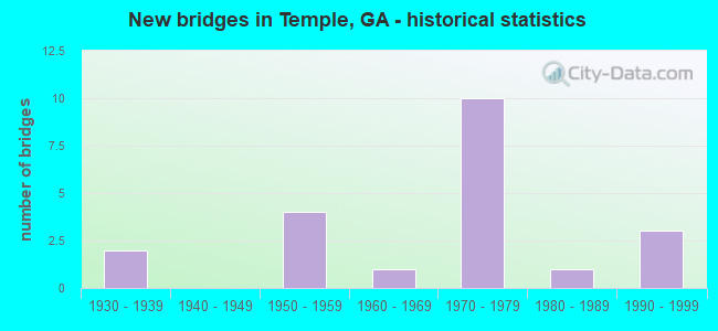
- New bridges - historical statistics
- 21930-1939
- 41950-1959
- 11960-1969
- 101970-1979
- 11980-1989
- 31990-1999
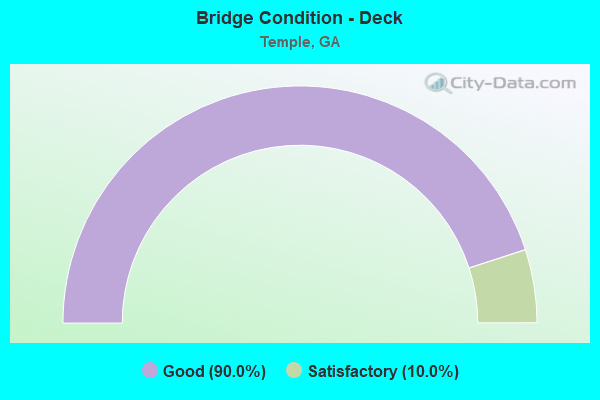
- Bridge Condition - Deck
- 90.0%Good
- 10.0%Satisfactory
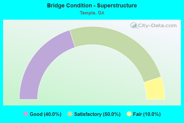
- Bridge Condition - Superstructure
- 40.0%Good
- 50.0%Satisfactory
- 10.0%Fair
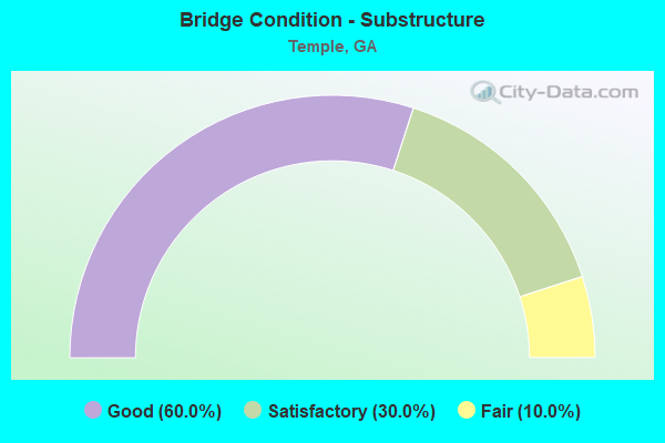
- Bridge Condition - Substructure
- 60.0%Good
- 30.0%Satisfactory
- 10.0%Fair
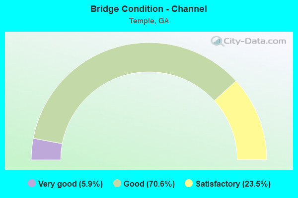
- Bridge Condition - Channel
- 5.9%Very good
- 70.6%Good
- 23.5%Satisfactory
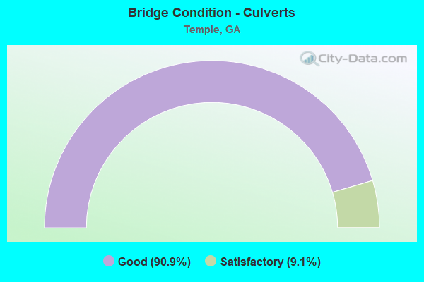
- Bridge Condition - Culverts
- 90.9%Good
- 9.1%Satisfactory
Find on map >> Show street view
Structure Number: 450022, Location: 1.5 MI E OF TEMPLE (Lat: 33.735703, Lng: -85.006261), Route carried "on" structure: US 78, Year Built: 1932, Status: Open, Structure Length: 1.34m (4.40ft), Average Daily Traffic: 6,120 (year 2011), Truck Traffic: 4%, Average Future Daily Traffic: 9,180 (year 2031), Design Load: H 15, Features Intersected: HOLLY CREEK
Minimum Vertical Clearance: 30+ m (98+ ft), Kilometerpoint: 4.828, Lanes on structure: 2, Base Highway Network: Yes, Owner: State Highway Agency, Approaching Roadway Width: 8.5m (27.9ft), Material/Design: Concrete, Design/Construction: Culvert, Number Of Spans In Main Unit: 4, Length of Maximum Span: 3.0m (9.8ft)
Condition: Channel: Good, Culverts: Good, Operating Rating: 53.5 metric tons, Method Used To Determine Operating Rating: Load Factor (LF), Inventory Rating: 31.7 metric tons, Method Used To Determine Inventory Rating: Load Factor (LF), Structural Evaluation: Better than present minimum criteria, Waterway Adequacy: Superior to present desirable criteria, Approach Roadway Alignment: Equal to present desirable criteria, Designated Inspection Frequency: Every 24 months, Inspection Date: July 2020, Bridge Improvement Cost: $172,000, Roadway Improvement Cost: $17,000, Total Project Cost: $258,000
Find on map >> Show street view
Structure Number: 450038, Location: 4 MI S OF TEMPLE (Lat: 33.683500, Lng: -85.021839), Route carried "on" structure: State highway 113, Year Built: 1950, Status: Open, Structure Length: 0.85m (2.79ft), Average Daily Traffic: 8,040 (year 2011), Truck Traffic: 6%, Average Future Daily Traffic: 12,060 (year 2031), Design Load: H 15, Features Intersected: ALLEN CREEK
Minimum Vertical Clearance: 30+ m (98+ ft), Kilometerpoint: 11.265, Lanes on structure: 2, Base Highway Network: Yes, Owner: State Highway Agency, Approaching Roadway Width: 8.5m (27.9ft), Material/Design: Steel, Design/Construction: Culvert, Number Of Spans In Main Unit: 2, Length of Maximum Span: 4.0m (13.1ft)
Condition: Channel: Good, Culverts: Good, Operating Rating: 42.6 metric tons, Method Used To Determine Operating Rating: Field evaluation and documented engineering judgment, Inventory Rating: 24.4 metric tons, Method Used To Determine Inventory Rating: Field evaluation and documented engineering judgment, Structural Evaluation: Equal to present minimum criteria, Waterway Adequacy: Superior to present desirable criteria, Approach Roadway Alignment: Equal to present desirable criteria, Designated Inspection Frequency: Every 24 months, Inspection Date: July 2020, Bridge Improvement Cost: $109,000, Roadway Improvement Cost: $11,000, Total Project Cost: $164,000
Find on map >> Show street view
Structure Number: 450039, Location: 2 MI S OF TEMPLE (Lat: 33.704828, Lng: -85.020750), Route carried "on" structure: State highway 113, Year Built: 1950, Status: Open, Structure Length: 1.37m (4.49ft), Average Daily Traffic: 8,040 (year 2011), Truck Traffic: 6%, Average Future Daily Traffic: 12,060 (year 2031), Design Load: H 15, Features Intersected: BETHEL CREEK
Minimum Vertical Clearance: 30+ m (98+ ft), Kilometerpoint: 14.484, Lanes on structure: 2, Base Highway Network: Yes, Owner: State Highway Agency, Approaching Roadway Width: 8.5m (27.9ft), Material/Design: Steel, Design/Construction: Culvert, Number Of Spans In Main Unit: 3, Length of Maximum Span: 4.0m (13.1ft)
Condition: Channel: Good, Culverts: Satisfactory, Operating Rating: 41.7 metric tons, Method Used To Determine Operating Rating: Field evaluation and documented engineering judgment, Inventory Rating: 24.4 metric tons, Method Used To Determine Inventory Rating: Field evaluation and documented engineering judgment, Structural Evaluation: Equal to present minimum criteria, Waterway Adequacy: Superior to present desirable criteria, Approach Roadway Alignment: Equal to present desirable criteria, Designated Inspection Frequency: Every 24 months, Inspection Date: July 2020, Bridge Improvement Cost: $176,000, Roadway Improvement Cost: $18,000, Total Project Cost: $264,000
Find on map >> Show street view
Structure Number: 45004, Location: 1.5 MI S OF TEMPLE (Lat: 33.716681, Lng: -85.027200), Route carried "on" structure: State highway 113, Year Built: 1976, Status: Open, Structure Length: 9.63m (31.59ft), Average Daily Traffic: 10,070 (year 2011), Truck Traffic: 1%, Average Future Daily Traffic: 15,105 (year 2031), Design Load: HS 20+Mod, Features Intersected: I-20
Minimum Vertical Clearance: 30+ m (98+ ft), Kilometerpoint: 14.484, Lanes on structure: 2, Lanes under structure: 4, Base Highway Network: Yes, Owner: State Highway Agency, Approaching Roadway Width: 17.1m (56.1ft), Skew: 1 degrees, Material/Design: Steel continuous, Design/Construction: Stringer/Multi-beam, Number Of Spans In Main Unit: 4, Length of Maximum Span: 31.1m (102.0ft), Curb-To-Curb Width: 18.0m (59.1ft), Out-to-Out Width: 19.0m (62.3ft)
Condition: Deck: Good, Superstructure: Good, Substructure: Good, Operating Rating: 46.2 metric tons, Method Used To Determine Operating Rating: Allowable Stress (AS), Inventory Rating: 32.6 metric tons, Method Used To Determine Inventory Rating: Allowable Stress (AS), Structural Evaluation: Better than present minimum criteria, Deck Geometry: Superior to present desirable criteria, Underclear: Better than present minimum criteria, Approach Roadway Alignment: Equal to present desirable criteria, Designated Inspection Frequency: Every 24 months, Inspection Date: September 2020, Bridge Improvement Cost: $1,235,000, Roadway Improvement Cost: $123,000, Total Project Cost: $1,852,000, Deck Structure Type: Concrete Cast-file-Place, Wearing Surface/Protective System: Wearing Surface: Epoxy Overlay
Find on map >> Show street view
Structure Number: 450041, Location: 1.5 MI N OF TEMPLE (Lat: 33.759606, Lng: -85.042050), Route carried "on" structure: State highway 113, Year Built: 1950, Status: Open, Structure Length: 0.64m (2.10ft), Average Daily Traffic: 3,490 (year 2011), Truck Traffic: 1%, Average Future Daily Traffic: 5,235 (year 2031), Design Load: H 15, Features Intersected: TRESTLE CREEK
Minimum Vertical Clearance: 30+ m (98+ ft), Kilometerpoint: 20.921, Lanes on structure: 2, Base Highway Network: Yes, Owner: State Highway Agency, Approaching Roadway Width: 7.9m (25.9ft), Material/Design: Concrete, Design/Construction: Culvert, Number Of Spans In Main Unit: 2, Length of Maximum Span: 3.0m (9.8ft)
Condition: Channel: Good, Culverts: Good, Structural Evaluation: Better than present minimum criteria, Waterway Adequacy: Superior to present desirable criteria, Approach Roadway Alignment: Equal to present desirable criteria, Designated Inspection Frequency: Every 24 months, Inspection Date: July 2020, Bridge Improvement Cost: $82,000, Roadway Improvement Cost: $8,000, Total Project Cost: $123,000
Find on map >> Show street view
Structure Number: 450051, Location: 3.5 MI SW OF TEMPLE (Lat: 33.698403, Lng: -85.069078), Route carried "on" structure: County highway 291, Year Built: 1976, Status: Open, Structure Length: 5.94m (19.49ft), Average Daily Traffic: 1,060 (year 2011), Truck Traffic: 1%, Average Future Daily Traffic: 1,590 (year 2031), Design Load: HS 15, Features Intersected: I-20 EBL, Facility Carried by Structure: LEVANS ROAD
Minimum Vertical Clearance: 30+ m (98+ ft), Kilometerpoint: 9.656, Lanes on structure: 2, Lanes under structure: 2, Base Highway Network: Yes, Owner: State Highway Agency, Approaching Roadway Width: 6.1m (20.0ft), Material/Design: Steel continuous, Design/Construction: Stringer/Multi-beam, Number Of Spans In Main Unit: 3, Length of Maximum Span: 27.7m (90.9ft), Curb or Sidewalk Widths: Left: 0.2m (0.7ft), Right: 0.2m (0.7ft), Curb-To-Curb Width: 9.4m (30.8ft), Out-to-Out Width: 10.5m (34.4ft)
Condition: Deck: Good, Superstructure: Good, Substructure: Good, Operating Rating: 28.1 metric tons, Method Used To Determine Operating Rating: Load Factor (LF), Inventory Rating: 16.3 metric tons, Method Used To Determine Inventory Rating: Load Factor (LF), Structural Evaluation: Meets minimum limits, Deck Geometry: Somewhat better than minimum adequacy, Underclear: Better than present minimum criteria, Approach Roadway Alignment: Equal to present desirable criteria, Designated Inspection Frequency: Every 24 months, Inspection Date: September 2020, Bridge Improvement Cost: $762,000, Roadway Improvement Cost: $76,000, Total Project Cost: $1,143,000, Deck Structure Type: Concrete Cast-file-Place
Find on map >> Show street view
Structure Number: 450052, Location: 3.5 MI SW OF TEMPLE (Lat: 33.699364, Lng: -85.069469), Route carried "on" structure: County highway 291, Year Built: 1976, Status: Open, Structure Length: 6.13m (20.11ft), Average Daily Traffic: 1,060 (year 2011), Truck Traffic: 1%, Average Future Daily Traffic: 1,590 (year 2031), Design Load: HS 15, Features Intersected: I-20 WBL, Facility Carried by Structure: LEVANS ROAD
Minimum Vertical Clearance: 30+ m (98+ ft), Kilometerpoint: 9.656, Lanes on structure: 2, Lanes under structure: 2, Base Highway Network: Yes, Owner: State Highway Agency, Approaching Roadway Width: 6.1m (20.0ft), Material/Design: Steel continuous, Design/Construction: Stringer/Multi-beam, Number Of Spans In Main Unit: 3, Length of Maximum Span: 27.7m (90.9ft), Curb or Sidewalk Widths: Left: 0.2m (0.7ft), Right: 0.2m (0.7ft), Curb-To-Curb Width: 9.4m (30.8ft), Out-to-Out Width: 10.5m (34.4ft)
Condition: Deck: Good, Superstructure: Good, Substructure: Good, Operating Rating: 30.8 metric tons, Method Used To Determine Operating Rating: Load Factor (LF), Inventory Rating: 18.1 metric tons, Method Used To Determine Inventory Rating: Load Factor (LF), Structural Evaluation: Somewhat better than minimum adequacy, Deck Geometry: Somewhat better than minimum adequacy, Underclear: Superior to present desirable criteria, Approach Roadway Alignment: Equal to present desirable criteria, Designated Inspection Frequency: Every 24 months, Inspection Date: September 2020, Bridge Improvement Cost: $785,000, Roadway Improvement Cost: $79,000, Total Project Cost: $1,178,000, Deck Structure Type: Concrete Cast-file-Place
Find on map >> Show street view
Structure Number: 450053, Location: 2 MI SE OF TEMPLE (Lat: 33.717908, Lng: -85.008628), Route carried "on" structure: County highway 319, Year Built: 1976, Status: Open, Structure Length: 10.03m (32.91ft), Average Daily Traffic: 600 (year 2011), Truck Traffic: 1%, Average Future Daily Traffic: 900 (year 2031), Design Load: HS 15, Features Intersected: I-20, Facility Carried by Structure: BAR-J ROAD
Minimum Vertical Clearance: 30+ m (98+ ft), Kilometerpoint: 1.609, Lanes on structure: 2, Lanes under structure: 4, Base Highway Network: Yes, Owner: State Highway Agency, Approaching Roadway Width: 6.1m (20.0ft), Skew: 2 degrees, Material/Design: Steel, Design/Construction: Stringer/Multi-beam, Number Of Spans In Main Unit: 4, Length of Maximum Span: 33.8m (110.9ft), Curb or Sidewalk Widths: Left: 0.1m (0.3ft), Right: 0.1m (0.3ft), Curb-To-Curb Width: 8.8m (28.9ft), Out-to-Out Width: 9.9m (32.5ft)
Condition: Deck: Good, Superstructure: Good, Substructure: Good, Operating Rating: 32.6 metric tons, Method Used To Determine Operating Rating: Load Factor (LF), Inventory Rating: 19.0 metric tons, Method Used To Determine Inventory Rating: Load Factor (LF), Structural Evaluation: Somewhat better than minimum adequacy, Deck Geometry: Somewhat better than minimum adequacy, Underclear: Equal to present minimum criteria, Approach Roadway Alignment: Equal to present desirable criteria, Designated Inspection Frequency: Every 24 months, Inspection Date: September 2020, Bridge Improvement Cost: $1,285,000, Roadway Improvement Cost: $129,000, Total Project Cost: $1,928,000, Deck Structure Type: Concrete Cast-file-Place
Find on map >> Show street view
Structure Number: 450061, Location: 1.5 MI S OF TEMPLE (Lat: 33.714969, Lng: -85.036522), Route carried "on" structure: Interstate 20, Year Built: 1976, Status: Open, Structure Length: 0.88m (2.89ft), Average Daily Traffic: 34,780 (year 2011), Truck Traffic: 1%, Average Future Daily Traffic: 52,170 (year 2031), Design Load: HS 20+Mod, Features Intersected: WEBSTER CREEK
Minimum Vertical Clearance: 30+ m (98+ ft), Kilometerpoint: 28.968, Lanes on structure: 4, Base Highway Network: Yes, Owner: State Highway Agency, Approaching Roadway Width: 23.2m (76.1ft), Skew: 11 degrees, Material/Design: Concrete, Design/Construction: Culvert, Number Of Spans In Main Unit: 3, Length of Maximum Span: 2.7m (8.9ft)
Condition: Channel: Good, Culverts: Good, Structural Evaluation: Better than present minimum criteria, Waterway Adequacy: Superior to present desirable criteria, Approach Roadway Alignment: Equal to present desirable criteria, Designated Inspection Frequency: Every 24 months, Inspection Date: September 2020, Bridge Improvement Cost: $175,000, Roadway Improvement Cost: $18,000, Total Project Cost: $263,000
Find on map >> Show street view
Structure Number: 450062, Location: 2.5 MI SE OF TEMPLE (Lat: 33.716878, Lng: -84.996428), Route carried "on" structure: Interstate 20, Year Built: 1976, Status: Open, Structure Length: 20.09m (65.91ft), Average Daily Traffic: 41,500 (year 2012), Truck Traffic: 1%, Average Future Daily Traffic: 62,250 (year 2032), Design Load: HS 20+Mod, Features Intersected: LITTLE TALLAPOOSA RIVER
Minimum Vertical Clearance: 30+ m (98+ ft), Kilometerpoint: 33.796, Lanes on structure: 2, Base Highway Network: Yes, Owner: State Highway Agency, Approaching Roadway Width: 11.6m (38.1ft), Skew: 10 degrees, Material/Design: Prestressed concrete, Design/Construction: Stringer/Multi-beam, Number Of Spans In Main Unit: 8, Length of Maximum Span: 25.0m (82.0ft), Curb-To-Curb Width: 13.0m (42.7ft), Out-to-Out Width: 14.2m (46.6ft)
Condition: Deck: Good, Superstructure: Satisfactory, Substructure: Good, Channel: Good, Operating Rating: 37.1 metric tons, Method Used To Determine Operating Rating: Load Factor (LF), Inventory Rating: 21.7 metric tons, Method Used To Determine Inventory Rating: Load Factor (LF), Structural Evaluation: Somewhat better than minimum adequacy, Deck Geometry: Superior to present desirable criteria, Waterway Adequacy: Equal to present minimum criteria, Approach Roadway Alignment: Equal to present desirable criteria, Designated Inspection Frequency: Every 24 months, Underwater Inspection Frequency: Every 60 months, Inspection Date: September 2020, Underwater Inspection Date: April 2020, Bridge Improvement Cost: $2,575,000, Roadway Improvement Cost: $257,000, Total Project Cost: $3,862,000, Deck Structure Type: Concrete Cast-file-Place
Find on map >> Show street view
Structure Number: 450063, Location: 2.5 MI SE OF TEMPLE (Lat: 33.717178, Lng: -84.996258), Route carried "on" structure: Interstate 20, Year Built: 1976, Status: Open, Structure Length: 17.59m (57.71ft), Average Daily Traffic: 41,500 (year 2012), Truck Traffic: 1%, Average Future Daily Traffic: 62,250 (year 2032), Design Load: HS 20+Mod, Features Intersected: LITTLE TALLAPOOSA RIVER
Minimum Vertical Clearance: 30+ m (98+ ft), Kilometerpoint: 33.796, Lanes on structure: 2, Base Highway Network: Yes, Owner: State Highway Agency, Approaching Roadway Width: 11.6m (38.1ft), Skew: 10 degrees, Material/Design: Prestressed concrete, Design/Construction: Stringer/Multi-beam, Number Of Spans In Main Unit: 7, Length of Maximum Span: 25.0m (82.0ft), Curb-To-Curb Width: 13.0m (42.7ft), Out-to-Out Width: 14.2m (46.6ft)
Condition: Deck: Good, Superstructure: Satisfactory, Substructure: Good, Channel: Good, Operating Rating: 37.1 metric tons, Method Used To Determine Operating Rating: Load Factor (LF), Inventory Rating: 21.7 metric tons, Method Used To Determine Inventory Rating: Load Factor (LF), Structural Evaluation: Somewhat better than minimum adequacy, Deck Geometry: Superior to present desirable criteria, Waterway Adequacy: Equal to present minimum criteria, Approach Roadway Alignment: Equal to present desirable criteria, Designated Inspection Frequency: Every 24 months, Underwater Inspection Frequency: Every 60 months, Inspection Date: September 2020, Underwater Inspection Date: April 2020, Bridge Improvement Cost: $2,254,000, Roadway Improvement Cost: $225,000, Total Project Cost: $3,382,000, Deck Structure Type: Concrete Cast-file-Place
Find on map >> Show street view
Structure Number: 450083, Location: 1 MI S OF TEMPLE (Lat: 33.720358, Lng: -85.039239), Route carried "on" structure: County highway 1809, Year Built: 1958, Status: Open, Structure Length: 0.64m (2.10ft), Average Daily Traffic: 1,570 (year 2011), Truck Traffic: 1%, Average Future Daily Traffic: 2,355 (year 2031), Design Load: H 15, Features Intersected: CHANCE CREEK, Facility Carried by Structure: TEMPLE-CENTERPOINT
Minimum Vertical Clearance: 30+ m (98+ ft), Kilometerpoint: 12.875, Lanes on structure: 2, Base Highway Network: Yes, Owner: County Highway Agency, Approaching Roadway Width: 6.1m (20.0ft), Material/Design: Concrete, Design/Construction: Culvert, Number Of Spans In Main Unit: 2, Length of Maximum Span: 3.0m (9.8ft)
Condition: Channel: Satisfactory, Culverts: Good, Operating Rating: 41.7 metric tons, Method Used To Determine Operating Rating: Field evaluation and documented engineering judgment, Inventory Rating: 24.4 metric tons, Method Used To Determine Inventory Rating: Field evaluation and documented engineering judgment, Structural Evaluation: Equal to present minimum criteria, Waterway Adequacy: Superior to present desirable criteria, Approach Roadway Alignment: Equal to present desirable criteria, Designated Inspection Frequency: Every 24 months, Inspection Date: July 2020, Bridge Improvement Cost: $82,000, Roadway Improvement Cost: $8,000, Total Project Cost: $123,000
Find on map >> Show street view
Structure Number: 45507, Location: 1.5 MI E OF TEMPLE (Lat: 33.738250, Lng: -85.007658), Route carried "on" structure: County highway 329, Year Built: 1990, Status: Open, Structure Length: 0.88m (2.89ft), Average Daily Traffic: 600 (year 2011), Truck Traffic: 1%, Average Future Daily Traffic: 900 (year 2031), Design Load: HS 20, Features Intersected: HOLLY CREEK, Facility Carried by Structure: TAYLOR GIN ROAD
Minimum Vertical Clearance: 30+ m (98+ ft), Kilometerpoint: 3.219, Lanes on structure: 2, Base Highway Network: Yes, Owner: County Highway Agency, Approaching Roadway Width: 6.1m (20.0ft), Material/Design: Concrete, Design/Construction: Culvert, Number Of Spans In Main Unit: 3, Length of Maximum Span: 2.7m (8.9ft)
Condition: Channel: Good, Culverts: Good, Operating Rating: 55.3 metric tons, Method Used To Determine Operating Rating: Field evaluation and documented engineering judgment, Inventory Rating: 32.6 metric tons, Method Used To Determine Inventory Rating: Field evaluation and documented engineering judgment, Structural Evaluation: Better than present minimum criteria, Waterway Adequacy: Better than present minimum criteria, Approach Roadway Alignment: Equal to present minimum criteria, Designated Inspection Frequency: Every 24 months, Inspection Date: July 2020, Bridge Improvement Cost: $113,000, Roadway Improvement Cost: $11,000, Total Project Cost: $170,000
Find on map >> Show street view
Structure Number: 455072, Location: 1 MI N OF TEMPLE (Lat: 33.754444, Lng: -85.031233), Route carried "on" structure: County highway 331, Year Built: 1960, Status: Posted for load, Structure Length: 1.28m (4.20ft), Average Daily Traffic: 600 (year 2011), Truck Traffic: 1%, Average Future Daily Traffic: 900 (year 2031), Features Intersected: TRESTLE CREEK, Facility Carried by Structure: ASBURY ROAD
Minimum Vertical Clearance: 30+ m (98+ ft), Kilometerpoint: 1.609, Lanes on structure: 2, Base Highway Network: Yes, Owner: County Highway Agency, Approaching Roadway Width: 6.1m (20.0ft), Material/Design: Steel continuous, Design/Construction: Stringer/Multi-beam, Number Of Spans In Main Unit: 2, Length of Maximum Span: 6.4m (21.0ft), Curb-To-Curb Width: 6.8m (22.3ft), Out-to-Out Width: 7.3m (24.0ft)
Condition: Deck: Satisfactory, Superstructure: Satisfactory, Substructure: Satisfactory, Channel: Good, Operating Rating: 20.8 metric tons, Method Used To Determine Operating Rating: Load Factor (LF), Inventory Rating: 15.4 metric tons, Method Used To Determine Inventory Rating: Load Factor (LF), Structural Evaluation: Meets minimum limits, Deck Geometry: Meets minimum limits, Waterway Adequacy: Somewhat better than minimum adequacy, Approach Roadway Alignment: Somewhat better than minimum adequacy, Bridge Posting: Required (Relationship of Operating Rating to Maximum Legal Load: > 39.9% below), Length Of Structure Improvement: 41.51m (136.19ft), Designated Inspection Frequency: Every 24 months, Inspection Date: July 2020, Bridge Improvement Cost: $164,000, Roadway Improvement Cost: $16,000, Total Project Cost: $246,000, Deck Structure Type: Concrete Cast-file-Place, Wearing Surface/Protective System: Wearing Surface: Bituminous
Find on map >> Show street view
Structure Number: 455125, Location: 6.5 MI SW OF VILLA RICA (Lat: 33.681642, Lng: -85.013394), Route carried "on" structure: County highway 824, Year Built: 1974, Status: Posted for load, Structure Length: 2.23m (7.32ft), Average Daily Traffic: 1,680 (year 2011), Truck Traffic: 1%, Average Future Daily Traffic: 2,520 (year 2031), Features Intersected: LITTLE TALLAPOOSA RIVER, Facility Carried by Structure: W HICKORY LEVEL RD
Minimum Vertical Clearance: 30+ m (98+ ft), Kilometerpoint: 11.265, Lanes on structure: 2, Base Highway Network: Yes, Owner: County Highway Agency, Approaching Roadway Width: 5.5m (18.0ft), Material/Design: Steel continuous, Design/Construction: Stringer/Multi-beam, Number Of Spans In Main Unit: 3, Length of Maximum Span: 8.8m (28.9ft), Curb-To-Curb Width: 6.9m (22.6ft), Out-to-Out Width: 7.3m (24.0ft)
Condition: Deck: Good, Superstructure: Satisfactory, Substructure: Satisfactory, Channel: Good, Operating Rating: 22.6 metric tons, Method Used To Determine Operating Rating: Load Factor (LF), Inventory Rating: 13.6 metric tons, Method Used To Determine Inventory Rating: Load Factor (LF), Structural Evaluation: Meets minimum limits, Deck Geometry: High priority of corrective action, Waterway Adequacy: Superior to present desirable criteria, Approach Roadway Alignment: Equal to present desirable criteria, Bridge Posting: Required (Relationship of Operating Rating to Maximum Legal Load: 30.0 - 39.9% below), Length Of Structure Improvement: 42.46m (139.30ft), Designated Inspection Frequency: Every 24 months, Inspection Date: August 2020, Bridge Improvement Cost: $285,000, Roadway Improvement Cost: $29,000, Total Project Cost: $428,000, Deck Structure Type: Concrete Cast-file-Place, Wearing Surface/Protective System: Wearing Surface: Bituminous
Find on map >> Show street view
Structure Number: 455126, Location: 6.5 MI SW OF VILLA RICA (Lat: 33.681633, Lng: -85.014822), Route carried "on" structure: County highway 824, Year Built: 1974, Status: Posted for load, Structure Length: 1.04m (3.41ft), Average Daily Traffic: 1,680 (year 2011), Truck Traffic: 1%, Average Future Daily Traffic: 2,520 (year 2031), Features Intersected: LITTLE TALLAPOOSA RIV TR, Facility Carried by Structure: W HICKORY LEVEL RD
Minimum Vertical Clearance: 30+ m (98+ ft), Kilometerpoint: 11.265, Lanes on structure: 2, Base Highway Network: Yes, Owner: County Highway Agency, Approaching Roadway Width: 5.5m (18.0ft), Material/Design: Steel continuous, Design/Construction: Stringer/Multi-beam, Number Of Spans In Main Unit: 2, Length of Maximum Span: 5.2m (17.1ft), Curb-To-Curb Width: 6.9m (22.6ft), Out-to-Out Width: 7.3m (24.0ft)
Condition: Deck: Good, Superstructure: Satisfactory, Substructure: Satisfactory, Channel: Satisfactory, Operating Rating: 58.9 metric tons, Method Used To Determine Operating Rating: Load Factor (LF), Inventory Rating: 34.4 metric tons, Method Used To Determine Inventory Rating: Load Factor (LF), Structural Evaluation: Equal to present minimum criteria, Deck Geometry: High priority of corrective action, Waterway Adequacy: Superior to present desirable criteria, Approach Roadway Alignment: Equal to present desirable criteria, Length Of Structure Improvement: 41.27m (135.40ft), Designated Inspection Frequency: Every 24 months, Inspection Date: August 2020, Bridge Improvement Cost: $133,000, Roadway Improvement Cost: $13,000, Total Project Cost: $199,000, Deck Structure Type: Concrete Cast-file-Place, Wearing Surface/Protective System: Wearing Surface: Bituminous
Find on map >> Show street view
Structure Number: 455127, Location: 4.5 MI SW OF VILLA RICA (Lat: 33.694619, Lng: -84.986483), Route carried "on" structure: County highway 830, Year Built: 1986, Status: Open, Structure Length: 0.64m (2.10ft), Average Daily Traffic: 570 (year 2011), Truck Traffic: 1%, Average Future Daily Traffic: 855 (year 2031), Design Load: H 15, Features Intersected: L. TALLAPOOSA RIVER TRIB, Facility Carried by Structure: PLEASANT GROVE CHU
Minimum Vertical Clearance: 30+ m (98+ ft), Kilometerpoint: 1.609, Lanes on structure: 2, Base Highway Network: Yes, Owner: County Highway Agency, Approaching Roadway Width: 6.1m (20.0ft), Material/Design: Steel, Design/Construction: Culvert, Number Of Spans In Main Unit: 3, Length of Maximum Span: 1.5m (4.9ft)
Condition: Channel: Very good, Culverts: Good, Operating Rating: 41.7 metric tons, Method Used To Determine Operating Rating: Field evaluation and documented engineering judgment, Inventory Rating: 24.4 metric tons, Method Used To Determine Inventory Rating: Field evaluation and documented engineering judgment, Structural Evaluation: Equal to present minimum criteria, Waterway Adequacy: Equal to present desirable criteria, Approach Roadway Alignment: Equal to present desirable criteria, Designated Inspection Frequency: Every 24 months, Inspection Date: July 2020, Bridge Improvement Cost: $82,000, Roadway Improvement Cost: $8,000, Total Project Cost: $123,000
Find on map >> Show street view
Structure Number: 455144, Location: 1 MI N OF TEMPLE (Lat: 33.752408, Lng: -85.018900), Route carried "on" structure: County highway 330, Year Built: 1997, Status: Open, Structure Length: 1.07m (3.51ft), Average Daily Traffic: 600 (year 2011), Truck Traffic: 1%, Average Future Daily Traffic: 900 (year 2031), Design Load: H 15, Features Intersected: TRESTLE CREEK, Facility Carried by Structure: RAINEY ROAD
Minimum Vertical Clearance: 30+ m (98+ ft), Kilometerpoint: 1.609, Lanes on structure: 2, Base Highway Network: Yes, Owner: County Highway Agency, Approaching Roadway Width: 6.1m (20.0ft), Material/Design: Steel, Design/Construction: Culvert, Number Of Spans In Main Unit: 3, Length of Maximum Span: 2.7m (8.9ft)
Condition: Channel: Good, Culverts: Good, Operating Rating: 41.7 metric tons, Method Used To Determine Operating Rating: Field evaluation and documented engineering judgment, Inventory Rating: 24.4 metric tons, Method Used To Determine Inventory Rating: Field evaluation and documented engineering judgment, Structural Evaluation: Equal to present minimum criteria, Waterway Adequacy: Superior to present desirable criteria, Approach Roadway Alignment: Equal to present desirable criteria, Designated Inspection Frequency: Every 24 months, Inspection Date: July 2020, Bridge Improvement Cost: $137,000, Roadway Improvement Cost: $14,000, Total Project Cost: $205,000
Find on map >> Show street view
Structure Number: 455147, Location: 1.5 MI S OF TEMPLE (Lat: 33.717172, Lng: -85.035336), Route carried "on" structure: County highway 739, Year Built: 1997, Status: Open, Structure Length: 1.34m (4.40ft), Average Daily Traffic: 600 (year 2011), Truck Traffic: 1%, Average Future Daily Traffic: 900 (year 2031), Design Load: HS 20+Mod, Features Intersected: WEBSTER CREEK, Facility Carried by Structure: BILLINGS ROAD
Minimum Vertical Clearance: 30+ m (98+ ft), Kilometerpoint: 0.000, Lanes on structure: 2, Base Highway Network: Yes, Owner: County Highway Agency, Approaching Roadway Width: 7.3m (24.0ft), Material/Design: Concrete, Design/Construction: Culvert, Number Of Spans In Main Unit: 4, Length of Maximum Span: 3.0m (9.8ft)
Condition: Channel: Good, Culverts: Good, Operating Rating: 55.3 metric tons, Method Used To Determine Operating Rating: Field evaluation and documented engineering judgment, Inventory Rating: 32.6 metric tons, Method Used To Determine Inventory Rating: Field evaluation and documented engineering judgment, Structural Evaluation: Better than present minimum criteria, Waterway Adequacy: Better than present minimum criteria, Approach Roadway Alignment: Equal to present desirable criteria, Length Of Structure Improvement: 41.21m (135.20ft), Designated Inspection Frequency: Every 24 months, Inspection Date: August 2020, Bridge Improvement Cost: $172,000, Roadway Improvement Cost: $17,000, Total Project Cost: $258,000
Find on map >> Show street view
Structure Number: 1430006, Location: 4.7 MI E OF BREMEN (Lat: 33.731489, Lng: -85.063858), Route carried "on" structure: US 78, Year Built: 1932, Year Reconstructed: 1976, Status: Open, Structure Length: 0.64m (2.10ft), Average Daily Traffic: 5,400 (year 2012), Truck Traffic: 1%, Average Future Daily Traffic: 8,100 (year 2032), Design Load: H 15, Features Intersected: CHANCE CREEK TRIB.
Minimum Vertical Clearance: 30+ m (98+ ft), Kilometerpoint: 30.578, Lanes on structure: 3, Owner: State Highway Agency, Approaching Roadway Width: 12.8m (42.0ft), Material/Design: Concrete, Design/Construction: Culvert, Number Of Spans In Main Unit: 2, Length of Maximum Span: 3.0m (9.8ft)
Condition: Channel: Satisfactory, Culverts: Good, Operating Rating: 66.2 metric tons, Method Used To Determine Operating Rating: Load Factor (LF), Inventory Rating: 39.9 metric tons, Method Used To Determine Inventory Rating: Load Factor (LF), Structural Evaluation: Better than present minimum criteria, Waterway Adequacy: Superior to present desirable criteria, Approach Roadway Alignment: Equal to present desirable criteria, Designated Inspection Frequency: Every 24 months, Inspection Date: January 2022, Bridge Improvement Cost: $104,000, Roadway Improvement Cost: $10,000, Total Project Cost: $157,000
Find on map >> Show street view
Structure Number: 1435011, Location: 5.5 MI E OF BREMEN (Lat: 33.723639, Lng: -85.050919), Route carried "on" structure: County highway 62, Year Built: 1976, Status: Open, Structure Length: 0.91m (2.99ft), Average Daily Traffic: 490 (year 2012), Truck Traffic: 1%, Average Future Daily Traffic: 735 (year 2032), Features Intersected: CHANCE CREEK, Facility Carried by Structure: HARMON ROAD
Minimum Vertical Clearance: 30+ m (98+ ft), Kilometerpoint: 1.609, Lanes on structure: 2, Owner: County Highway Agency, Approaching Roadway Width: 6.1m (20.0ft), Material/Design: Steel, Design/Construction: Stringer/Multi-beam, Number Of Spans In Main Unit: 1, Length of Maximum Span: 9.1m (29.9ft), Curb-To-Curb Width: 7.2m (23.6ft), Out-to-Out Width: 7.2m (23.6ft)
Condition: Deck: Good, Superstructure: Fair, Substructure: Fair, Channel: Satisfactory, Operating Rating: 41.7 metric tons, Method Used To Determine Operating Rating: Load Factor (LF), Inventory Rating: 25.4 metric tons, Method Used To Determine Inventory Rating: Load Factor (LF), Structural Evaluation: Somewhat better than minimum adequacy, Deck Geometry: Meets minimum limits, Waterway Adequacy: Better than present minimum criteria, Approach Roadway Alignment: Better than present minimum criteria, Length Of Structure Improvement: 7.35m (24.11ft), Designated Inspection Frequency: Every 24 months, Inspection Date: January 2022, Bridge Improvement Cost: $117,000, Roadway Improvement Cost: $12,000, Total Project Cost: $176,000, Deck Structure Type: Concrete Cast-file-Place, Wearing Surface/Protective System: Wearing Surface: Bituminous
Find on map >> Show street view
Structure Number: 45004, Location: 1.5 MI S OF TEMPLE (Lat: 33.716681, Lng: -85.027200), Route carried "under" structure: Interstate 20, Structure Length: 0. m, Average Daily Traffic: 39,000 (year 1999), Truck Traffic: 1%, Features Intersected: SR 113, Facility Carried by Structure: SR 113
Minimum Vertical Clearance: 5.91m (19.39ft), Kilometerpoint: 30.578, Lanes on structure: 2, Length of Maximum Span: 0.0m
Find on map >> Show street view
Structure Number: 450051, Location: 3.5 MI SW OF TEMPLE (Lat: 33.698403, Lng: -85.069078), Route carried "under" structure: Interstate 20, Structure Length: 0. m, Average Daily Traffic: 36,100 (year 1999), Truck Traffic: 1%, Features Intersected: CR 291 LEVANS ROAD, Facility Carried by Structure: LEVANS ROAD
Minimum Vertical Clearance: 5.18m (16.99ft), Kilometerpoint: 25.750, Lanes on structure: 2, Length of Maximum Span: 0.0m
Find on map >> Show street view
Structure Number: 450052, Location: 3.5 MI SW OF TEMPLE (Lat: 33.699364, Lng: -85.069469), Route carried "under" structure: Interstate 20, Structure Length: 0. m, Average Daily Traffic: 36,100 (year 1999), Truck Traffic: 1%, Features Intersected: CR 291 LEVANS ROAD, Facility Carried by Structure: LEVANS ROAD
Minimum Vertical Clearance: 5.61m (18.41ft), Kilometerpoint: 25.750, Lanes on structure: 2, Length of Maximum Span: 0.0m
Find on map >> Show street view
Structure Number: 450053, Location: 2 MI SE OF TEMPLE (Lat: 33.717908, Lng: -85.008628), Route carried "under" structure: Interstate 20, Structure Length: 0. m, Average Daily Traffic: 39,000 (year 1999), Truck Traffic: 1%, Features Intersected: CR 319 BAR-J ROAD, Facility Carried by Structure: BAR-J ROAD
Minimum Vertical Clearance: 5.51m (18.08ft), Kilometerpoint: 32.187, Lanes on structure: 2, Length of Maximum Span: 0.0m
Find on map >> Show street view
Structure Number: 450082, Location: 2 MI S OF TEMPLE (Lat: 33.712039, Lng: -85.043008), Route carried "under" structure: Interstate 20, Structure Length: 0. m, Average Daily Traffic: 36,100 (year 1999), Truck Traffic: 1%, Features Intersected: S-1809 CENTERPOINT-TEMPL, Facility Carried by Structure: TEMPLE-CENTERPOINT
Minimum Vertical Clearance: 5.53m (18.14ft), Kilometerpoint: 28.968, Lanes on structure: 2, Length of Maximum Span: 0.0m