Bridge Statistics for The Galena Territory, Illinois (IL)
Condition, Traffic, Stress, Structural Evaluation, Project Costs
- National Bridge Inventory (NBI) Statistics
- 24Number of bridges
- 118ft / 36.1mTotal length
- $407,000Total costs
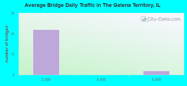
- 15,150Total average daily traffic
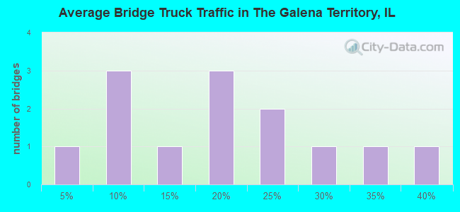
- 2,287Total average daily truck traffic
- National Bridge Inventory (NBI) Registered Bridges for The Galena Territory
- No street view available for this location
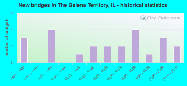
- New bridges - historical statistics
- 31900-1909
- 41920-1929
- 11940-1949
- 21950-1959
- 21960-1969
- 21970-1979
- 41980-1989
- 11990-1999
- 32000-2009
- 22010-2019
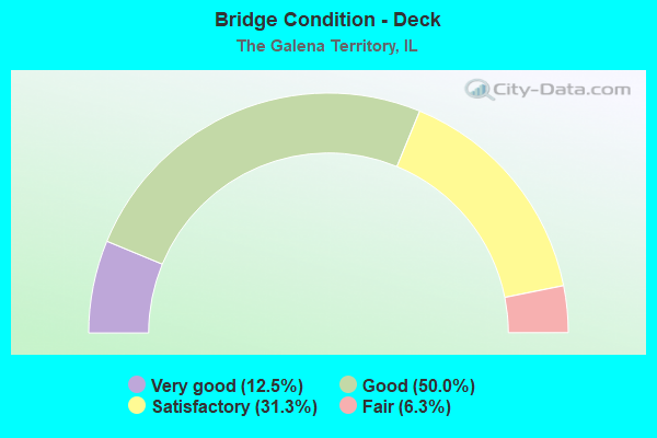
- Bridge Condition - Deck
- 12.5%Very good
- 50.0%Good
- 31.3%Satisfactory
- 6.3%Fair
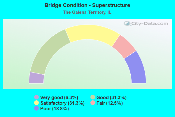
- Bridge Condition - Superstructure
- 6.3%Very good
- 31.3%Good
- 31.3%Satisfactory
- 12.5%Fair
- 18.8%Poor
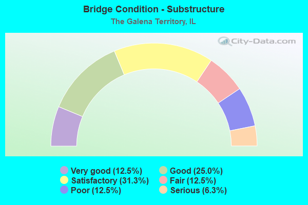
- Bridge Condition - Substructure
- 12.5%Very good
- 25.0%Good
- 31.3%Satisfactory
- 12.5%Fair
- 12.5%Poor
- 6.3%Serious
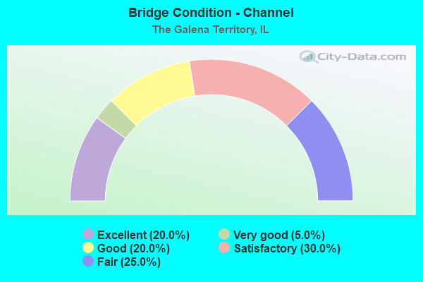
- Bridge Condition - Channel
- 20.0%Excellent
- 5.0%Very good
- 20.0%Good
- 30.0%Satisfactory
- 25.0%Fair
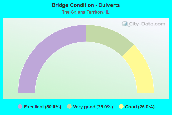
- Bridge Condition - Culverts
- 50.0%Excellent
- 25.0%Very good
- 25.0%Good
Find on map >> Show street view
Structure Number: 430035, Location: 3.8 MI SE OF GALENA (Lat: 42.383917, Lng: -90.372742), Route carried "on" structure: US 20, Year Built: 1971, Status: Open, Structure Length: 6.47m (21.23ft), Average Daily Traffic: 5,750 (year 2021), Truck Traffic: 16%, Average Future Daily Traffic: 6,500 (year 2040), Design Load: HS 20, Features Intersected: SMALLPOX CREEK
Minimum Vertical Clearance: 30+ m (98+ ft), Kilometerpoint: 30.384, Lanes on structure: 2, Base Highway Network: Yes, Owner: State Highway Agency, Approaching Roadway Width: 13.4m (44.0ft), Skew: 3 degrees, Material/Design: Prestressed concrete continuous, Design/Construction: Stringer/Multi-beam, Number Of Spans In Main Unit: 3, Length of Maximum Span: 21.0m (68.9ft), Curb-To-Curb Width: 9.3m (30.5ft), Out-to-Out Width: 10.4m (34.1ft)
Condition: Deck: Satisfactory, Superstructure: Fair, Substructure: Satisfactory, Channel: Good, Operating Rating: 57.7 metric tons, Method Used To Determine Operating Rating: Load Factor (LF) rating reported by rating factor (RF) method using MS18 loading, Inventory Rating: 34.7 metric tons, Method Used To Determine Inventory Rating: Load Factor (LF) rating reported by rating factor (RF) method using MS18 loading, Structural Evaluation: Somewhat better than minimum adequacy, Deck Geometry: Meets minimum limits, Waterway Adequacy: Equal to present desirable criteria, Approach Roadway Alignment: Equal to present minimum criteria, Designated Inspection Frequency: Every 24 months, Inspection Date: October 2021, Deck Structure Type: Concrete Cast-file-Place, Wearing Surface/Protective System: Wearing Surface: Bituminous, Membrane: Built-up
Find on map >> Show street view
Structure Number: 431077, Location: .58MI NW GLEN HOLLOW (Lat: 42.377547, Lng: -90.360181), Route carried "on" structure: US 20, Year Built: 2009, Status: Open, Structure Length: 0.75m (2.46ft), Average Daily Traffic: 5,750 (year 2021), Truck Traffic: 16%, Average Future Daily Traffic: 6,100 (year 2040), Design Load: HS 20+Mod, Features Intersected: TRIB TO SMALL POX CR
Minimum Vertical Clearance: 30+ m (98+ ft), Kilometerpoint: 31.655, Lanes on structure: 2, Base Highway Network: Yes, Owner: State Highway Agency, Approaching Roadway Width: 12.2m (40.0ft), Skew: 4 degrees, Material/Design: Concrete, Design/Construction: Culvert, Number Of Spans In Main Unit: 2, Length of Maximum Span: 3.4m (11.2ft)
Condition: Channel: Good, Culverts: Good, Operating Rating: 71.6 metric tons, Method Used To Determine Operating Rating: Load Factor (LF) rating reported by rating factor (RF) method using MS18 loading, Inventory Rating: 43.1 metric tons, Method Used To Determine Inventory Rating: Load Factor (LF) rating reported by rating factor (RF) method using MS18 loading, Structural Evaluation: Better than present minimum criteria, Waterway Adequacy: Equal to present desirable criteria, Approach Roadway Alignment: Equal to present desirable criteria, Designated Inspection Frequency: Every 48 months, Inspection Date: November 2021
Find on map >> Show street view
Structure Number: 433025, Location: 5 MI NE OF GALENA (Lat: 42.474481, Lng: -90.318503), Route carried "on" structure: County highway , Year Built: 1940, Status: Posted for load, Structure Length: 0.90m (2.95ft), Average Daily Traffic: 275 (year 2021), Truck Traffic: 39%, Average Future Daily Traffic: 350 (year 2040), Features Intersected: E FK OF GALENA RIVER, Facility Carried by Structure: W COUNCIL HILL ROA
Minimum Vertical Clearance: 30+ m (98+ ft), Kilometerpoint: 13.534, Lanes on structure: 1, Owner: County Highway Agency, Approaching Roadway Width: 4.9m (16.1ft), Material/Design: Steel, Design/Construction: Stringer/Multi-beam, Number Of Spans In Main Unit: 1, Length of Maximum Span: 8.5m (27.9ft), Curb-To-Curb Width: 3.0m (9.8ft), Out-to-Out Width: 4.5m (14.8ft)
Condition: Deck: Very good, Superstructure: Satisfactory, Substructure: Poor, Channel: Fair, Operating Rating: 43.4 metric tons, Method Used To Determine Operating Rating: Load Factor (LF) rating reported by rating factor (RF) method using MS18 loading, Inventory Rating: 25.9 metric tons, Method Used To Determine Inventory Rating: Load Factor (LF) rating reported by rating factor (RF) method using MS18 loading, Structural Evaluation: Meets minimum limits, Deck Geometry: High priority of replacement, Waterway Adequacy: Meets minimum limits, Approach Roadway Alignment: Somewhat better than minimum adequacy, Bridge Posting: Required (Relationship of Operating Rating to Maximum Legal Load: > 39.9% below), Length Of Structure Improvement: 1.55m (5.09ft), Designated Inspection Frequency: Every 24 months, Inspection Date: October 2020, Bridge Improvement Cost: $42,000, Roadway Improvement Cost: $4,000, Total Project Cost: $63,000, Deck Structure Type: Wood or Timber, Wearing Surface/Protective System: Wearing Surface: Wood or Timber
Find on map >> Show street view
Structure Number: 433052, Location: 3 MILES SE GALENA (Lat: 42.373986, Lng: -90.382444), Route carried "on" structure: County highway , Year Built: 1963, Status: Open, Structure Length: 1.52m (4.99ft), Average Daily Traffic: 100 (year 2021), Truck Traffic: 22%, Average Future Daily Traffic: 150 (year 2040), Design Load: HS 15, Features Intersected: SMALLPOX CREEK, Facility Carried by Structure: TOWNSHIP ROAD NO.
Minimum Vertical Clearance: 30+ m (98+ ft), Kilometerpoint: 2.317, Lanes on structure: 2, Owner: Town or Township Highway Agency, Approaching Roadway Width: 4.9m (16.1ft), Material/Design: Steel, Design/Construction: Stringer/Multi-beam, Number Of Spans In Main Unit: 1, Length of Maximum Span: 14.9m (48.9ft), Curb-To-Curb Width: 6.1m (20.0ft), Out-to-Out Width: 7.4m (24.3ft)
Condition: Deck: Good, Superstructure: Poor, Substructure: Poor, Channel: Fair, Operating Rating: 48.3 metric tons, Method Used To Determine Operating Rating: Load Factor (LF) rating reported by rating factor (RF) method using MS18 loading, Inventory Rating: 28.8 metric tons, Method Used To Determine Inventory Rating: Load Factor (LF) rating reported by rating factor (RF) method using MS18 loading, Structural Evaluation: Meets minimum limits, Deck Geometry: Somewhat better than minimum adequacy, Waterway Adequacy: Equal to present desirable criteria, Approach Roadway Alignment: Somewhat better than minimum adequacy, Designated Inspection Frequency: Every 24 months, Inspection Date: March 2020, Deck Structure Type: Concrete Cast-file-Place, Wearing Surface/Protective System: Deck Protection: Internally Sealed
Find on map >> Show street view
Structure Number: 433062, Location: 7 MI NW ELIZABETH (Lat: 42.341956, Lng: -90.347744), Route carried "on" structure: County highway , Year Built: 1957, Status: Open, Structure Length: 1.10m (3.61ft), Average Daily Traffic: 150 (year 2021), Truck Traffic: 15%, Average Future Daily Traffic: 75 (year 2040), Design Load: HS 15, Features Intersected: IRISH HOLLOW CREEK, Facility Carried by Structure: TOWNSHIP ROAD NO 5
Minimum Vertical Clearance: 30+ m (98+ ft), Kilometerpoint: 4.104, Lanes on structure: 2, Owner: Town or Township Highway Agency, Approaching Roadway Width: 4.9m (16.1ft), Material/Design: Steel, Design/Construction: Stringer/Multi-beam, Number Of Spans In Main Unit: 1, Length of Maximum Span: 11.0m (36.1ft), Curb-To-Curb Width: 6.1m (20.0ft), Out-to-Out Width: 6.9m (22.6ft)
Condition: Deck: Good, Superstructure: Good, Substructure: Good, Channel: Satisfactory, Operating Rating: 35.0 metric tons, Method Used To Determine Operating Rating: Load Factor (LF) rating reported by rating factor (RF) method using MS18 loading, Inventory Rating: 21.1 metric tons, Method Used To Determine Inventory Rating: Load Factor (LF) rating reported by rating factor (RF) method using MS18 loading, Structural Evaluation: Equal to present minimum criteria, Deck Geometry: Meets minimum limits, Waterway Adequacy: Better than present minimum criteria, Approach Roadway Alignment: Better than present minimum criteria, Designated Inspection Frequency: Every 24 months, Inspection Date: October 2020, Deck Structure Type: Concrete Cast-file-Place
Find on map >> Show street view
Structure Number: 433064, Location: 5 MI W ELIZABETH (Lat: 42.328803, Lng: -90.321083), Route carried "on" structure: County highway , Year Built: 1922, Status: Open, Structure Length: 1.31m (4.30ft), Average Daily Traffic: 75 (year 2021), Average Future Daily Traffic: 75 (year 2040), Features Intersected: IRISH HOLLOW CREEK, Facility Carried by Structure: TOWNSHIP ROAD NO.
Minimum Vertical Clearance: 30+ m (98+ ft), Kilometerpoint: 7.161, Lanes on structure: 1, Owner: Town or Township Highway Agency, Approaching Roadway Width: 7.9m (25.9ft), Material/Design: Concrete, Number Of Spans In Main Unit: 1, Length of Maximum Span: 12.8m (42.0ft), Curb-To-Curb Width: 4.9m (16.1ft), Out-to-Out Width: 5.9m (19.4ft)
Condition: Deck: Satisfactory, Superstructure: Fair, Substructure: Satisfactory, Channel: Satisfactory, Operating Rating: 40.5 metric tons, Method Used To Determine Operating Rating: Field evaluation and documented engineering judgment, Inventory Rating: 24.3 metric tons, Method Used To Determine Inventory Rating: Field evaluation and documented engineering judgment, Structural Evaluation: Somewhat better than minimum adequacy, Deck Geometry: High priority of corrective action, Waterway Adequacy: Equal to present minimum criteria, Approach Roadway Alignment: Equal to present minimum criteria, Length Of Structure Improvement: 1.98m (6.50ft), Designated Inspection Frequency: Every 24 months, Inspection Date: October 2020, Bridge Improvement Cost: $73,000, Roadway Improvement Cost: $7,000, Total Project Cost: $110,000, Deck Structure Type: Concrete Cast-file-Place
Find on map >> Show street view
Structure Number: 433071, Location: 2.5 MI NE GALENA (Lat: 42.462689, Lng: -90.365089), Route carried "on" structure: County highway , Year Built: 1901, Status: Open, Structure Length: 1.43m (4.69ft), Average Daily Traffic: 25 (year 2021), Average Future Daily Traffic: 25 (year 2040), Features Intersected: E FORK GALENA RIV, Facility Carried by Structure: KELLY RD
Minimum Vertical Clearance: 30+ m (98+ ft), Kilometerpoint: 0.016, Lanes on structure: 1, Owner: Railroad, Approaching Roadway Width: 4.9m (16.1ft), Material/Design: Concrete, Design/Construction: Slab, Number Of Spans In Main Unit: 3, Length of Maximum Span: 4.6m (15.1ft), Curb-To-Curb Width: 4.0m (13.1ft), Out-to-Out Width: 4.3m (14.1ft)
Condition: Deck: Satisfactory, Superstructure: Satisfactory, Substructure: Fair, Channel: Fair, Operating Rating: 29.2 metric tons, Method Used To Determine Operating Rating: Field evaluation and documented engineering judgment, Inventory Rating: 17.5 metric tons, Method Used To Determine Inventory Rating: Field evaluation and documented engineering judgment, Structural Evaluation: Somewhat better than minimum adequacy, Deck Geometry: Somewhat better than minimum adequacy, Waterway Adequacy: Somewhat better than minimum adequacy, Approach Roadway Alignment: High priority of corrective action, Length Of Structure Improvement: 1.43m (4.69ft), Designated Inspection Frequency: Every 24 months, Inspection Date: March 2020, Bridge Improvement Cost: $11,000, Roadway Improvement Cost: $1,000, Total Project Cost: $13,000, Deck Structure Type: Concrete Cast-file-Place
Find on map >> Show street view
Structure Number: 433074, Location: 6 MI E GALENA (Lat: 42.418386, Lng: -90.301897), Route carried "on" structure: County highway , Year Built: 1957, Status: Open, Structure Length: 1.28m (4.20ft), Average Daily Traffic: 375 (year 2021), Truck Traffic: 27%, Average Future Daily Traffic: 500 (year 2040), Design Load: HS 15, Features Intersected: SMALLPOX CREEK, Facility Carried by Structure: TOWNSHIP ROAD NO.
Minimum Vertical Clearance: 30+ m (98+ ft), Kilometerpoint: 5.423, Lanes on structure: 2, Owner: Town or Township Highway Agency, Approaching Roadway Width: 7.3m (24.0ft), Material/Design: Steel, Design/Construction: Stringer/Multi-beam, Number Of Spans In Main Unit: 1, Length of Maximum Span: 12.8m (42.0ft), Curb-To-Curb Width: 6.1m (20.0ft), Out-to-Out Width: 6.7m (22.0ft)
Condition: Deck: Good, Superstructure: Poor, Substructure: Serious, Channel: Satisfactory, Operating Rating: 46.7 metric tons, Method Used To Determine Operating Rating: Load Factor (LF) rating reported by rating factor (RF) method using MS18 loading, Inventory Rating: 27.9 metric tons, Method Used To Determine Inventory Rating: Load Factor (LF) rating reported by rating factor (RF) method using MS18 loading, Structural Evaluation: High priority of corrective action, Deck Geometry: Meets minimum limits, Waterway Adequacy: Equal to present minimum criteria, Approach Roadway Alignment: Equal to present desirable criteria, Length Of Structure Improvement: 1.92m (6.30ft), Designated Inspection Frequency: Every 24 months, Inspection Date: April 2020, Bridge Improvement Cost: $81,000, Roadway Improvement Cost: $8,000, Total Project Cost: $122,000, Deck Structure Type: Concrete Cast-file-Place, Wearing Surface/Protective System: Wearing Surface: Bituminous
Find on map >> Show street view
Structure Number: 433094, Location: 6 MI. E. OF GALENA (Lat: 42.425808, Lng: -90.291439), Route carried "on" structure: County highway , Year Built: 1960, Status: Open, Structure Length: 1.07m (3.51ft), Average Daily Traffic: 50 (year 2021), Average Future Daily Traffic: 75 (year 2040), Design Load: HS 15, Features Intersected: SMALLPOX CREEK, Facility Carried by Structure: TOWNSHIP ROAD NO 9
Minimum Vertical Clearance: 30+ m (98+ ft), Kilometerpoint: 1.191, Lanes on structure: 2, Owner: Town or Township Highway Agency, Approaching Roadway Width: 7.3m (24.0ft), Material/Design: Steel, Design/Construction: Stringer/Multi-beam, Number Of Spans In Main Unit: 1, Length of Maximum Span: 10.4m (34.1ft), Curb-To-Curb Width: 6.2m (20.3ft), Out-to-Out Width: 6.9m (22.6ft)
Condition: Deck: Satisfactory, Superstructure: Satisfactory, Substructure: Satisfactory, Channel: Satisfactory, Operating Rating: 38.6 metric tons, Method Used To Determine Operating Rating: Load Factor (LF) rating reported by rating factor (RF) method using MS18 loading, Inventory Rating: 23.0 metric tons, Method Used To Determine Inventory Rating: Load Factor (LF) rating reported by rating factor (RF) method using MS18 loading, Structural Evaluation: Equal to present minimum criteria, Deck Geometry: Somewhat better than minimum adequacy, Waterway Adequacy: Equal to present minimum criteria, Approach Roadway Alignment: Equal to present desirable criteria, Designated Inspection Frequency: Every 24 months, Inspection Date: March 2020, Deck Structure Type: Concrete Cast-file-Place, Wearing Surface/Protective System: Wearing Surface: Gravel
Find on map >> Show street view
Structure Number: 433105, Location: 2.5 MI NW ELIZABETH (Lat: 42.349206, Lng: -90.252383), Route carried "on" structure: County highway , Year Built: 1921, Status: Open, Structure Length: 1.19m (3.90ft), Average Daily Traffic: 75 (year 2021), Truck Traffic: 21%, Average Future Daily Traffic: 75 (year 2040), Features Intersected: SNIPE HOLLOW BRANCH, Facility Carried by Structure: TOWNSHIP ROAD NO 1
Minimum Vertical Clearance: 30+ m (98+ ft), Kilometerpoint: 4.216, Lanes on structure: 1, Owner: Town or Township Highway Agency, Approaching Roadway Width: 6.7m (22.0ft), Material/Design: Concrete, Number Of Spans In Main Unit: 1, Length of Maximum Span: 11.6m (38.1ft), Curb-To-Curb Width: 5.0m (16.4ft), Out-to-Out Width: 5.9m (19.4ft)
Condition: Deck: Fair, Superstructure: Satisfactory, Substructure: Satisfactory, Channel: Fair, Operating Rating: 40.5 metric tons, Method Used To Determine Operating Rating: Field evaluation and documented engineering judgment, Inventory Rating: 24.3 metric tons, Method Used To Determine Inventory Rating: Field evaluation and documented engineering judgment, Structural Evaluation: Equal to present minimum criteria, Deck Geometry: High priority of corrective action, Waterway Adequacy: Equal to present minimum criteria, Approach Roadway Alignment: Equal to present minimum criteria, Length Of Structure Improvement: 1.89m (6.20ft), Designated Inspection Frequency: Every 24 months, Inspection Date: October 2020, Bridge Improvement Cost: $66,000, Roadway Improvement Cost: $7,000, Total Project Cost: $99,000, Deck Structure Type: Concrete Cast-file-Place
Find on map >> Show street view
Structure Number: 433186, Location: 6 MI. W. ELIZABETH (Lat: 42.335331, Lng: -90.340128), Route carried "on" structure: County highway , Year Built: 1996, Status: Open, Structure Length: 3.41m (11.19ft), Average Daily Traffic: 75 (year 2021), Average Future Daily Traffic: 100 (year 2040), Design Load: HS 20, Features Intersected: IRISH HOLLOW CREEK, Facility Carried by Structure: IRISH HOLLOW RD/TR
Minimum Vertical Clearance: 30+ m (98+ ft), Kilometerpoint: 5.407, Lanes on structure: 2, Owner: Town or Township Highway Agency, Approaching Roadway Width: 5.5m (18.0ft), Material/Design: Prestressed concrete, Design/Construction: Box Beam or Girders - Multiple, Number Of Spans In Main Unit: 3, Length of Maximum Span: 12.8m (42.0ft), Curb-To-Curb Width: 7.3m (24.0ft), Out-to-Out Width: 7.3m (24.0ft)
Condition: Deck: Satisfactory, Superstructure: Satisfactory, Substructure: Very good, Channel: Very good, Operating Rating: 44.1 metric tons, Method Used To Determine Operating Rating: Assigned rating based on Load Factor Design (LFD) reported by rating factor (RF) using MS18 loading, Inventory Rating: 32.4 metric tons, Method Used To Determine Inventory Rating: Assigned rating based on Load Factor Design (LFD) reported by rating factor (RF) using MS18 loading, Structural Evaluation: Equal to present minimum criteria, Deck Geometry: Equal to present minimum criteria, Waterway Adequacy: Equal to present desirable criteria, Approach Roadway Alignment: Better than present minimum criteria, Designated Inspection Frequency: Every 24 months, Inspection Date: March 2021, Deck Structure Type: Concrete Precast Panels
Find on map >> Show street view
Structure Number: 433205, Location: 2 MILES E GALENA (Lat: 42.434919, Lng: -90.372511), Route carried "on" structure: County highway , Year Built: 1977, Status: Open, Structure Length: 1.16m (3.81ft), Average Daily Traffic: 50 (year 2021), Average Future Daily Traffic: 150 (year 2040), Design Load: HS 20, Features Intersected: BR OF GALENA RIVER, Facility Carried by Structure: NORTH MINER ROAD
Minimum Vertical Clearance: 30+ m (98+ ft), Kilometerpoint: 4.409, Lanes on structure: 2, Owner: Town or Township Highway Agency, Approaching Roadway Width: 7.3m (24.0ft), Material/Design: Concrete, Design/Construction: Channel Beam, Number Of Spans In Main Unit: 1, Length of Maximum Span: 11.0m (36.1ft), Curb-To-Curb Width: 7.3m (24.0ft), Out-to-Out Width: 7.9m (25.9ft)
Condition: Deck: Good, Superstructure: Good, Substructure: Good, Channel: Good, Operating Rating: 44.4 metric tons, Method Used To Determine Operating Rating: Assigned rating based on Load Factor Design (LFD) reported by rating factor (RF) using MS18 loading, Inventory Rating: 32.4 metric tons, Method Used To Determine Inventory Rating: Assigned rating based on Load Factor Design (LFD) reported by rating factor (RF) using MS18 loading, Structural Evaluation: Better than present minimum criteria, Deck Geometry: Equal to present minimum criteria, Waterway Adequacy: Equal to present desirable criteria, Approach Roadway Alignment: Equal to present minimum criteria, Designated Inspection Frequency: Every 48 months, Inspection Date: March 2018, Deck Structure Type: Concrete Precast Panels
Find on map >> Show street view
Structure Number: 433214, Location: 3 MI W OF SCHAPVILLE (Lat: 42.393539, Lng: -90.261431), Route carried "on" structure: County highway , Year Built: 1981, Status: Open, Structure Length: 0.79m (2.59ft), Average Daily Traffic: 75 (year 2021), Truck Traffic: 7%, Average Future Daily Traffic: 150 (year 2040), Design Load: HS 20, Features Intersected: SNIPE HOLLOW CREEK, Facility Carried by Structure: MORLEY RD
Minimum Vertical Clearance: 30+ m (98+ ft), Kilometerpoint: 7.451, Lanes on structure: 2, Owner: Town or Township Highway Agency, Approaching Roadway Width: 6.1m (20.0ft), Skew: 1 degrees, Material/Design: Prestressed concrete, Design/Construction: Box Beam or Girders - Multiple, Number Of Spans In Main Unit: 1, Length of Maximum Span: 7.3m (24.0ft), Curb-To-Curb Width: 7.3m (24.0ft), Out-to-Out Width: 7.3m (24.0ft)
Condition: Deck: Good, Superstructure: Good, Substructure: Good, Channel: Satisfactory, Operating Rating: 44.4 metric tons, Method Used To Determine Operating Rating: Assigned rating based on Load Factor Design (LFD) reported by rating factor (RF) using MS18 loading, Inventory Rating: 32.4 metric tons, Method Used To Determine Inventory Rating: Assigned rating based on Load Factor Design (LFD) reported by rating factor (RF) using MS18 loading, Structural Evaluation: Better than present minimum criteria, Deck Geometry: Equal to present minimum criteria, Waterway Adequacy: Equal to present desirable criteria, Approach Roadway Alignment: Equal to present desirable criteria, Designated Inspection Frequency: Every 48 months, Inspection Date: March 2018, Deck Structure Type: Concrete Precast Panels
Find on map >> Show street view
Structure Number: 433216, Location: 4.5 M W OF ELIZABETH (Lat: 42.326725, Lng: -90.318131), Route carried "on" structure: County highway , Year Built: 1983, Status: Open, Structure Length: 2.56m (8.40ft), Average Daily Traffic: 75 (year 2021), Average Future Daily Traffic: 75 (year 2040), Design Load: HS 20, Features Intersected: IRISH HOLLOW CREEK, Facility Carried by Structure: S IRISH HOLLOW ROA
Minimum Vertical Clearance: 30+ m (98+ ft), Kilometerpoint: 7.499, Lanes on structure: 2, Owner: Town or Township Highway Agency, Approaching Roadway Width: 4.9m (16.1ft), Material/Design: Prestressed concrete, Design/Construction: Box Beam or Girders - Multiple, Number Of Spans In Main Unit: 3, Length of Maximum Span: 8.2m (26.9ft), Curb-To-Curb Width: 7.3m (24.0ft), Out-to-Out Width: 7.3m (24.0ft)
Condition: Deck: Good, Superstructure: Good, Substructure: Fair, Channel: Fair, Operating Rating: 44.4 metric tons, Method Used To Determine Operating Rating: Assigned rating based on Load Factor Design (LFD) reported by rating factor (RF) using MS18 loading, Inventory Rating: 32.4 metric tons, Method Used To Determine Inventory Rating: Assigned rating based on Load Factor Design (LFD) reported by rating factor (RF) using MS18 loading, Structural Evaluation: Somewhat better than minimum adequacy, Deck Geometry: Equal to present minimum criteria, Waterway Adequacy: Equal to present minimum criteria, Approach Roadway Alignment: Equal to present desirable criteria, Designated Inspection Frequency: Every 24 months, Inspection Date: October 2020, Deck Structure Type: Concrete Precast Panels
Find on map >> Show street view
Structure Number: 433218, Location: 4 MI NE OF GALENA (Lat: 42.467722, Lng: -90.338614), Route carried "on" structure: County highway , Year Built: 1983, Status: Open, Structure Length: 3.72m (12.20ft), Average Daily Traffic: 100 (year 2021), Truck Traffic: 33%, Average Future Daily Traffic: 200 (year 2040), Design Load: HS 20, Features Intersected: E FORK GALENA RIVER, Facility Carried by Structure: NORTH FORD ROAD
Minimum Vertical Clearance: 30+ m (98+ ft), Kilometerpoint: 0.161, Lanes on structure: 2, Owner: Town or Township Highway Agency, Approaching Roadway Width: 8.5m (27.9ft), Skew: 1 degrees, Material/Design: Prestressed concrete, Design/Construction: Box Beam or Girders - Multiple, Number Of Spans In Main Unit: 3, Length of Maximum Span: 15.2m (49.9ft), Curb-To-Curb Width: 7.3m (24.0ft), Out-to-Out Width: 8.5m (27.9ft)
Condition: Deck: Good, Superstructure: Poor, Substructure: Satisfactory, Channel: Good, Operating Rating: 58.6 metric tons, Method Used To Determine Operating Rating: Load Factor (LF) rating reported by rating factor (RF) method using MS18 loading, Inventory Rating: 22.0 metric tons, Method Used To Determine Inventory Rating: Load Factor (LF) rating reported by rating factor (RF) method using MS18 loading, Structural Evaluation: Meets minimum limits, Deck Geometry: Equal to present minimum criteria, Waterway Adequacy: Equal to present desirable criteria, Approach Roadway Alignment: Equal to present minimum criteria, Designated Inspection Frequency: Every 24 months, Inspection Date: March 2020, Deck Structure Type: Concrete Precast Panels
Find on map >> Show street view
Structure Number: 43323, Location: 1 MI W OF SCHAPVILLE (Lat: 42.395581, Lng: -90.226358), Route carried "on" structure: County highway , Year Built: 1985, Status: Open, Structure Length: 1.80m (5.91ft), Average Daily Traffic: 75 (year 2021), Truck Traffic: 5%, Average Future Daily Traffic: 75 (year 2040), Design Load: HS 20, Features Intersected: UNNAMED CREEK, Facility Carried by Structure: TR 71A
Minimum Vertical Clearance: 30+ m (98+ ft), Kilometerpoint: 3.186, Lanes on structure: 2, Owner: Town or Township Highway Agency, Approaching Roadway Width: 7.3m (24.0ft), Material/Design: Prestressed concrete, Design/Construction: Box Beam or Girders - Multiple, Number Of Spans In Main Unit: 1, Length of Maximum Span: 17.1m (56.1ft), Curb-To-Curb Width: 7.3m (24.0ft), Out-to-Out Width: 7.3m (24.0ft)
Condition: Deck: Good, Superstructure: Good, Substructure: Good, Channel: Satisfactory, Operating Rating: 44.4 metric tons, Method Used To Determine Operating Rating: Assigned rating based on Load Factor Design (LFD) reported by rating factor (RF) using MS18 loading, Inventory Rating: 32.4 metric tons, Method Used To Determine Inventory Rating: Assigned rating based on Load Factor Design (LFD) reported by rating factor (RF) using MS18 loading, Structural Evaluation: Better than present minimum criteria, Deck Geometry: Equal to present minimum criteria, Waterway Adequacy: Equal to present minimum criteria, Approach Roadway Alignment: Equal to present minimum criteria, Designated Inspection Frequency: Every 48 months, Inspection Date: March 2018, Deck Structure Type: Concrete Precast Panels
Find on map >> Show street view
Structure Number: 43326, Location: 6 MI E OF GALENA (Lat: 42.414636, Lng: -90.296497), Route carried "on" structure: County highway , Year Built: 2000, Status: Open, Structure Length: 1.87m (6.14ft), Average Daily Traffic: 100 (year 2021), Truck Traffic: 9%, Average Future Daily Traffic: 250 (year 2040), Design Load: HS 20, Features Intersected: TRIB SMALL POX CREEK, Facility Carried by Structure: COGAN LANE (TR 88)
Minimum Vertical Clearance: 30+ m (98+ ft), Kilometerpoint: 0.080, Lanes on structure: 2, Owner: Town or Township Highway Agency, Approaching Roadway Width: 5.5m (18.0ft), Skew: 2 degrees, Material/Design: Prestressed concrete, Design/Construction: Box Beam or Girders - Multiple, Number Of Spans In Main Unit: 1, Length of Maximum Span: 18.0m (59.1ft), Curb-To-Curb Width: 7.3m (24.0ft), Out-to-Out Width: 7.3m (24.0ft)
Condition: Deck: Very good, Superstructure: Very good, Substructure: Very good, Channel: Excellent, Operating Rating: 44.1 metric tons, Method Used To Determine Operating Rating: Assigned rating based on Load Factor Design (LFD) reported by rating factor (RF) using MS18 loading, Inventory Rating: 32.4 metric tons, Method Used To Determine Inventory Rating: Assigned rating based on Load Factor Design (LFD) reported by rating factor (RF) using MS18 loading, Structural Evaluation: Equal to present desirable criteria, Deck Geometry: Equal to present minimum criteria, Waterway Adequacy: Superior to present desirable criteria, Approach Roadway Alignment: Equal to present desirable criteria, Designated Inspection Frequency: Every 48 months, Inspection Date: March 2020, Deck Structure Type: Concrete Precast Panels
Find on map >> Show street view
Structure Number: 433266, Location: 7.3 MI E GALENA (Lat: 42.417317, Lng: -90.336489), Route carried "on" structure: County highway , Year Built: 2005, Status: Open, Structure Length: 1.54m (5.05ft), Average Daily Traffic: 900 (year 2021), Truck Traffic: 14%, Average Future Daily Traffic: 750 (year 2040), Design Load: HS 20, Features Intersected: BR. SMALLPOX CR, Facility Carried by Structure: RAWLINS RD
Minimum Vertical Clearance: 30+ m (98+ ft), Kilometerpoint: 2.366, Lanes on structure: 2, Owner: Town or Township Highway Agency, Approaching Roadway Width: 7.3m (24.0ft), Skew: 3 degrees, Material/Design: Concrete, Design/Construction: Culvert, Number Of Spans In Main Unit: 3, Length of Maximum Span: 4.0m (13.1ft)
Condition: Channel: Excellent, Culverts: Very good, Operating Rating: 44.1 metric tons, Method Used To Determine Operating Rating: Assigned rating based on Load Factor Design (LFD) reported by rating factor (RF) using MS18 loading, Inventory Rating: 32.4 metric tons, Method Used To Determine Inventory Rating: Assigned rating based on Load Factor Design (LFD) reported by rating factor (RF) using MS18 loading, Structural Evaluation: Equal to present desirable criteria, Waterway Adequacy: Superior to present desirable criteria, Approach Roadway Alignment: Superior to present desirable criteria, Designated Inspection Frequency: Every 48 months, Inspection Date: October 2020
Find on map >> Show street view
Structure Number: 433279, Location: 5.5MI NW ELIZABETH (Lat: 42.371989, Lng: -90.296233), Route carried "on" structure: County highway , Year Built: 2016, Status: Open, Structure Length: 1.25m (4.10ft), Average Daily Traffic: 450 (year 2021), Truck Traffic: 1%, Average Future Daily Traffic: 700 (year 2035), Design Load: HS 25 or greater, Features Intersected: FURNACE CREEK, Facility Carried by Structure: LONG HOLLOW RD
Minimum Vertical Clearance: 30+ m (98+ ft), Kilometerpoint: 2.671, Lanes on structure: 2, Owner: Town or Township Highway Agency, Approaching Roadway Width: 12.2m (40.0ft), Skew: 2 degrees, Material/Design: Concrete, Design/Construction: Culvert, Number Of Spans In Main Unit: 3, Length of Maximum Span: 3.7m (12.1ft), Curb-To-Curb Width: 12.5m (41.0ft)
Condition: Channel: Excellent, Culverts: Excellent, Operating Rating: 42.1 metric tons, Method Used To Determine Operating Rating: Assigned ratings based on Load and Resistance Factor Design (LRFD) reported by rating factor (RF) using HL93 loadings, Inventory Rating: 32.4 metric tons, Method Used To Determine Inventory Rating: Assigned ratings based on Load and Resistance Factor Design (LRFD) reported by rating factor (RF) using HL93 loadings, Structural Evaluation: Equal to present desirable criteria, Deck Geometry: Superior to present desirable criteria, Waterway Adequacy: Superior to present desirable criteria, Approach Roadway Alignment: Superior to present desirable criteria, Designated Inspection Frequency: Every 48 months, Inspection Date: October 2018
Find on map >> Show street view
Structure Number: 433282, Location: 5.7 MI NW ELIZABETH (Lat: 42.373889, Lng: -90.297033), Route carried "on" structure: County highway , Year Built: 2016, Status: Open, Structure Length: 0.96m (3.15ft), Average Daily Traffic: 500 (year 2021), Average Future Daily Traffic: 500 (year 2035), Design Load: HS 25 or greater, Features Intersected: BR FURNACE CREEK, Facility Carried by Structure: BRODRECHT RD
Minimum Vertical Clearance: 30+ m (98+ ft), Kilometerpoint: 2.720, Lanes on structure: 2, Owner: Town or Township Highway Agency, Approaching Roadway Width: 6.7m (22.0ft), Skew: 3 degrees, Material/Design: Concrete, Design/Construction: Culvert, Number Of Spans In Main Unit: 2, Length of Maximum Span: 3.7m (12.1ft)
Condition: Channel: Excellent, Culverts: Excellent, Operating Rating: 42.1 metric tons, Method Used To Determine Operating Rating: Assigned ratings based on Load and Resistance Factor Design (LRFD) reported by rating factor (RF) using HL93 loadings, Inventory Rating: 32.4 metric tons, Method Used To Determine Inventory Rating: Assigned ratings based on Load and Resistance Factor Design (LRFD) reported by rating factor (RF) using HL93 loadings, Structural Evaluation: Equal to present desirable criteria, Waterway Adequacy: Superior to present desirable criteria, Approach Roadway Alignment: Superior to present desirable criteria, Designated Inspection Frequency: Every 48 months, Inspection Date: October 2018
Find on map >> Show street view
Structure Number: 439908, Location: 3 MI NE GALENA (Lat: 42.463911, Lng: -90.354069), Route carried "under" structure: County highway , Year Built: 1900, Structure Length: 0. m, Average Daily Traffic: 25 (year 2021), Features Intersected: POSEY HILL RD, Facility Carried by Structure: CN RR
Minimum Vertical Clearance: 4.14m (13.58ft), Kilometerpoint: 0.032, Lanes under structure: 2, Material/Design: Masonry, Design/Construction: Arch - Deck, Length of Maximum Span: 4.0m (13.1ft)
Find on map >> Show street view
Structure Number: 43991, Location: 2.5 MI NE GALENA (Lat: 42.462664, Lng: -90.364903), Route carried "under" structure: County highway , Year Built: 1922, Structure Length: 0. m, Average Daily Traffic: 25 (year 2021), Features Intersected: KELLY RD, Facility Carried by Structure: CN RR
Minimum Vertical Clearance: 3.73m (12.24ft), Kilometerpoint: 0.032, Lanes under structure: 2, Material/Design: Steel, Design/Construction: Girder and Floorbeam System, Length of Maximum Span: 31.1m (102.0ft)
Find on map >> Show street view
Structure Number: 439911, Location: 2.8 MI NE GALENA (Lat: 42.463803, Lng: -90.358369), Route carried "under" structure: County highway , Year Built: 1900, Structure Length: 0. m, Average Daily Traffic: 25 (year 2021), Features Intersected: KELLY RD, Facility Carried by Structure: CN RR
Minimum Vertical Clearance: 3.66m (12.01ft), Kilometerpoint: 0.628, Lanes under structure: 2, Material/Design: Masonry, Design/Construction: Arch - Deck, Length of Maximum Span: 4.6m (15.1ft)
Find on map >> Show street view
Structure Number: 439912, Location: 3.5 MI NE GALENA (Lat: 42.467939, Lng: -90.339069), Route carried "under" structure: County highway , Year Built: 1921, Structure Length: 0. m, Average Daily Traffic: 50 (year 2021), Features Intersected: KELLY RD, Facility Carried by Structure: CN RR
Minimum Vertical Clearance: 5.66m (18.57ft), Kilometerpoint: 2.655, Lanes under structure: 2, Material/Design: Steel, Design/Construction: Box Beam or Girders - Multiple, Length of Maximum Span: 8.5m (27.9ft)