Bridge Statistics for Thorsby, Alabama (AL)
Condition, Traffic, Stress, Structural Evaluation, Project Costs
- National Bridge Inventory (NBI) Statistics
- 10Number of bridges
- 46ft / 14.4mTotal length
- $7,039,000Total costs
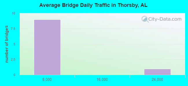
- 31,346Total average daily traffic
- 2,788Total average daily truck traffic
- 38,683Total future (year 2029) average daily traffic
- National Bridge Inventory (NBI) Registered Bridges for Thorsby
- No street view available for this location
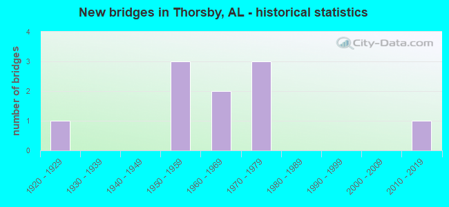
- New bridges - historical statistics
- 11920-1929
- 31950-1959
- 21960-1969
- 31970-1979
- 12010-2019
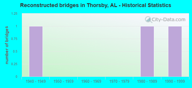
- Reconstructed bridges - Historical Statistics
- 11940-1949
- 01950-1959
- 01960-1969
- 01970-1979
- 11980-1989
- 11990-1999
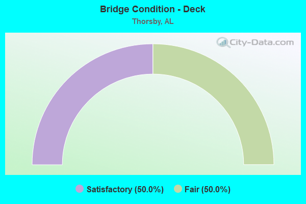
- Bridge Condition - Deck
- 50.0%Satisfactory
- 50.0%Fair
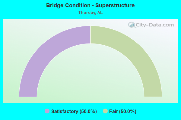
- Bridge Condition - Superstructure
- 50.0%Satisfactory
- 50.0%Fair
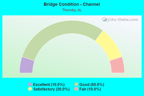
- Bridge Condition - Channel
- 10.0%Excellent
- 60.0%Good
- 20.0%Satisfactory
- 10.0%Fair
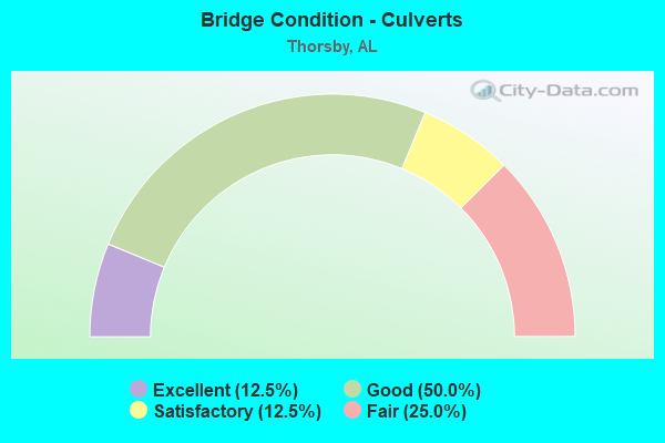
- Bridge Condition - Culverts
- 12.5%Excellent
- 50.0%Good
- 12.5%Satisfactory
- 25.0%Fair
Find on map >> Show street view
Structure Number: 4187, Location: 6775 FT W JCT 69 (Lat: 34.361753, Lng: -86.448067), Route carried "on" structure: County highway 418, Year Built: 1951, Status: Open, Structure Length: 1.18m (3.87ft), Average Daily Traffic: 1,100 (year 1994), Truck Traffic: 1%, Average Future Daily Traffic: 1,400 (year 2040), Design Load: H 10, Features Intersected: SHOAL CREEK, Facility Carried by Structure: COUNTY HIGHWAY141
Minimum Vertical Clearance: 30+ m (98+ ft), Kilometerpoint: 0.010, Lanes on structure: 2, Owner: County Highway Agency, Approaching Roadway Width: 9.1m (29.9ft), Material/Design: Concrete, Design/Construction: Culvert, Number Of Spans In Main Unit: 3, Length of Maximum Span: 3.7m (12.1ft)
Condition: Channel: Good, Culverts: Fair, Operating Rating: 36.4 metric tons, Method Used To Determine Operating Rating: Load Factor (LF), Inventory Rating: 21.8 metric tons, Method Used To Determine Inventory Rating: Load Factor (LF), Structural Evaluation: Somewhat better than minimum adequacy, Waterway Adequacy: Better than present minimum criteria, Approach Roadway Alignment: Equal to present desirable criteria, Length Of Structure Improvement: 1.85m (6.07ft), Designated Inspection Frequency: Every 24 months, Inspection Date: April 2020, Bridge Improvement Cost: $385,000, Roadway Improvement Cost: $39,000, Total Project Cost: $424,000 ( Estimate for 2022), Wearing Surface/Protective System: Wearing Surface: Bituminous
Find on map >> Show street view
Structure Number: 4192, Location: 1730 FT S JCT 1372 (Lat: 34.268706, Lng: -86.130289), Route carried "on" structure: County highway 548, Year Built: 1970, Status: Open, Structure Length: 0.67m (2.20ft), Average Daily Traffic: 150 (year 2000), Truck Traffic: 1%, Average Future Daily Traffic: 400 (year 2040), Design Load: H 10, Features Intersected: CREEK, Facility Carried by Structure: COUNTY HIGHWAY154
Minimum Vertical Clearance: 30+ m (98+ ft), Kilometerpoint: 0.010, Lanes on structure: 2, Owner: County Highway Agency, Approaching Roadway Width: 7.9m (25.9ft), Material/Design: Concrete, Design/Construction: Culvert, Number Of Spans In Main Unit: 2, Length of Maximum Span: 3.0m (9.8ft)
Condition: Channel: Good, Culverts: Fair, Operating Rating: 48.6 metric tons, Method Used To Determine Operating Rating: Load Factor (LF), Inventory Rating: 29.1 metric tons, Method Used To Determine Inventory Rating: Load Factor (LF), Structural Evaluation: Somewhat better than minimum adequacy, Waterway Adequacy: Equal to present minimum criteria, Approach Roadway Alignment: Equal to present desirable criteria, Length Of Structure Improvement: 1.30m (4.27ft), Designated Inspection Frequency: Every 24 months, Inspection Date: October 2020, Bridge Improvement Cost: $255,000, Roadway Improvement Cost: $26,000, Total Project Cost: $281,000 ( Estimate for 2022), Wearing Surface/Protective System: Wearing Surface: Gravel
Find on map >> Show street view
Structure Number: 4193, Location: 3420 FT N JCT 1513 (Lat: 34.374275, Lng: -86.145181), Route carried "on" structure: County highway 562, Year Built: 1951, Status: Posted for load, Structure Length: 1.01m (3.31ft), Average Daily Traffic: 136 (year 2000), Truck Traffic: 1%, Average Future Daily Traffic: 200 (year 2040), Design Load: H 10, Features Intersected: DRY CREEK, Facility Carried by Structure: CLAUDE HILL RD.
Minimum Vertical Clearance: 7.56m (24.80ft), Kilometerpoint: 0.010, Lanes on structure: 2, Owner: County Highway Agency, Approaching Roadway Width: 7.9m (25.9ft), Material/Design: Steel, Design/Construction: Stringer/Multi-beam, Number Of Spans In Main Unit: 1, Length of Maximum Span: 9.4m (30.8ft), Curb-To-Curb Width: 5.4m (17.7ft), Out-to-Out Width: 5.9m (19.4ft)
Condition: Deck: Fair, Superstructure: Fair, Substructure: Satisfactory, Channel: Good, Operating Rating: 5.4 metric tons, Method Used To Determine Operating Rating: Load Factor (LF), Inventory Rating: 2.7 metric tons, Method Used To Determine Inventory Rating: Load Factor (LF), Structural Evaluation: High priority of replacement, Deck Geometry: High priority of replacement, Waterway Adequacy: Superior to present desirable criteria, Approach Roadway Alignment: Equal to present desirable criteria, Bridge Posting: Required (Relationship of Operating Rating to Maximum Legal Load: > 39.9% below), Length Of Structure Improvement: 1.68m (5.51ft), Designated Inspection Frequency: Every 24 months, Other Special Inspection Frequency: Every 12 months, Inspection Date: November 2020, Other Special Inspection Date: November 2021, Bridge Improvement Cost: $219,000, Roadway Improvement Cost: $22,000, Total Project Cost: $241,000 ( Estimate for 2022), Deck Structure Type: Concrete Cast-file-Place, Wearing Surface/Protective System: Wearing Surface: Bituminous
Find on map >> Show street view
Structure Number: 4197, Location: VERBENA (Lat: 32.755167, Lng: -86.512433), Route carried "on" structure: US 31, Year Built: 1925, Year Reconstructed: 1952, Status: Open, Structure Length: 4.36m (14.30ft), Average Daily Traffic: 4,070 (year 2013), Truck Traffic: 10%, Average Future Daily Traffic: 5,228 (year 2033), Design Load: H 15, Features Intersected: CHESTNUT CREEK
Minimum Vertical Clearance: 30+ m (98+ ft), Kilometerpoint: 341.532, Lanes on structure: 2, Base Highway Network: Yes, Owner: State Highway Agency, Approaching Roadway Width: 13.4m (44.0ft), Material/Design: Concrete, Design/Construction: Tee Beam, Number Of Spans In Main Unit: 5, Length of Maximum Span: 8.7m (28.5ft), Curb or Sidewalk Widths: Left: 0.7m (2.3ft), Right: 0.7m (2.3ft), Curb-To-Curb Width: 10.9m (35.8ft), Out-to-Out Width: 13.1m (43.0ft)
Condition: Deck: Satisfactory, Superstructure: Satisfactory, Substructure: Satisfactory, Channel: Satisfactory, Operating Rating: 42.0 metric tons, Method Used To Determine Operating Rating: Load Factor (LF), Inventory Rating: 25.2 metric tons, Method Used To Determine Inventory Rating: Load Factor (LF), Structural Evaluation: Equal to present minimum criteria, Deck Geometry: Somewhat better than minimum adequacy, Waterway Adequacy: Equal to present minimum criteria, Approach Roadway Alignment: Equal to present minimum criteria, Length Of Structure Improvement: 5.34m (17.52ft), Designated Inspection Frequency: Every 24 months, Inspection Date: March 2020, Bridge Improvement Cost: $1,575,000, Roadway Improvement Cost: $158,000, Total Project Cost: $1,733,000 ( Estimate for 2022), Deck Structure Type: Concrete Cast-file-Place, Wearing Surface/Protective System: Wearing Surface: Bituminous
Find on map >> Show street view
Structure Number: 6108, Location: CR50 1M NE PATES CHAPELCH (Lat: 32.916356, Lng: -86.744267), Route carried "on" structure: County highway , Year Built: 1958, Status: Open, Structure Length: 1.10m (3.61ft), Average Daily Traffic: 1,200 (year 1985), Truck Traffic: 1%, Average Future Daily Traffic: 1,350 (year 2030), Design Load: H 20, Features Intersected: PATE CREEK, Facility Carried by Structure: CR50PLEASANT GRV R
Minimum Vertical Clearance: 30+ m (98+ ft), Kilometerpoint: 0.010, Lanes on structure: 2, Owner: County Highway Agency, Approaching Roadway Width: 7.9m (25.9ft), Material/Design: Concrete, Design/Construction: Culvert, Number Of Spans In Main Unit: 3, Length of Maximum Span: 3.7m (12.1ft)
Condition: Channel: Satisfactory, Culverts: Good, Operating Rating: 69.9 metric tons, Method Used To Determine Operating Rating: Load Factor (LF), Inventory Rating: 41.9 metric tons, Method Used To Determine Inventory Rating: Load Factor (LF), Structural Evaluation: Better than present minimum criteria, Waterway Adequacy: Better than present minimum criteria, Approach Roadway Alignment: Somewhat better than minimum adequacy, Length Of Structure Improvement: 1.77m (5.81ft), Designated Inspection Frequency: Every 24 months, Inspection Date: October 2020, Bridge Improvement Cost: $471,000, Roadway Improvement Cost: $47,000, Total Project Cost: $518,000 ( Estimate for 2022), Wearing Surface/Protective System: Wearing Surface: Bituminous
Find on map >> Show street view
Structure Number: 1062, Location: 0.7MI N.US.231 (Lat: 32.421944, Lng: -86.243333), Route carried "on" structure: Bypass State highway 152, Year Built: 1971, Status: Open, Structure Length: 1.01m (3.31ft), Average Daily Traffic: 23,320 (year 2013), Truck Traffic: 10%, Average Future Daily Traffic: 28,455 (year 2033), Design Load: HS 20, Features Intersected: STREAM
Minimum Vertical Clearance: 30+ m (98+ ft), Kilometerpoint: 9.461, Lanes on structure: 4, Base Highway Network: Yes, Owner: State Highway Agency, Approaching Roadway Width: 24.4m (80.1ft), Skew: 10 degrees, Material/Design: Concrete continuous, Design/Construction: Culvert, Number Of Spans In Main Unit: 3, Length of Maximum Span: 3.0m (9.8ft)
Condition: Channel: Fair, Culverts: Satisfactory, Operating Rating: 88.9 metric tons, Method Used To Determine Operating Rating: Load Factor (LF), Inventory Rating: 88.9 metric tons, Method Used To Determine Inventory Rating: Load Factor (LF), Structural Evaluation: Equal to present minimum criteria, Waterway Adequacy: Superior to present desirable criteria, Approach Roadway Alignment: Better than present minimum criteria, Length Of Structure Improvement: 1.68m (5.51ft), Designated Inspection Frequency: Every 24 months, Inspection Date: November 2020, Bridge Improvement Cost: $1,504,000, Roadway Improvement Cost: $150,000, Total Project Cost: $1,654,000 ( Estimate for 2022)
Find on map >> Show street view
Structure Number: 16509, Location: CR229 2 MSW CROSSROAD SCH (Lat: 32.869894, Lng: -86.732694), Route carried "on" structure: County highway , Year Built: 1971, Year Reconstructed: 1993, Status: Open, Structure Length: 0.91m (2.99ft), Average Daily Traffic: 220 (year 1999), Truck Traffic: 10%, Average Future Daily Traffic: 300 (year 2029), Features Intersected: CR229 EILAND BRANCH, Facility Carried by Structure: CR229 LIVEOAK ROAD
Minimum Vertical Clearance: 0.00m, Kilometerpoint: 0.010, Lanes on structure: 2, Toll: Toll bridge is a segment, Owner: County Highway Agency, Approaching Roadway Width: 9.1m (29.9ft), Material/Design: Concrete, Design/Construction: Culvert, Number Of Spans In Main Unit: 2, Length of Maximum Span: 3.7m (12.1ft), Curb-To-Curb Width: 6.7m (22.0ft), Out-to-Out Width: 6.7m (22.0ft)
Condition: Channel: Good, Culverts: Good, Operating Rating: 88.9 metric tons, Method Used To Determine Operating Rating: Load Factor (LF), Inventory Rating: 88.3 metric tons, Method Used To Determine Inventory Rating: Load Factor (LF), Structural Evaluation: Better than present minimum criteria, Deck Geometry: High priority of replacement, Waterway Adequacy: Better than present minimum criteria, Approach Roadway Alignment: Equal to present desirable criteria, Length Of Structure Improvement: 1.58m (5.18ft), Designated Inspection Frequency: Every 24 months, Inspection Date: October 2020, Bridge Improvement Cost: $602,000, Roadway Improvement Cost: $60,000, Total Project Cost: $662,000 ( Estimate for 2022)
Find on map >> Show street view
Structure Number: 17046, Location: CR5 1.2M NE MT.CARMEL CH (Lat: 32.883000, Lng: -86.755031), Route carried "on" structure: County highway , Year Built: 1969, Year Reconstructed: 1998, Status: Open, Structure Length: 1.49m (4.89ft), Average Daily Traffic: 200 (year 1997), Average Future Daily Traffic: 210 (year 2029), Design Load: H 15, Features Intersected: GALE CREEK, Facility Carried by Structure: CR5 MT CARMEL RD
Minimum Vertical Clearance: 7.56m (24.80ft), Kilometerpoint: 0.014, Lanes on structure: 2, Owner: County Highway Agency, Approaching Roadway Width: 6.7m (22.0ft), Material/Design: Concrete, Design/Construction: Culvert, Number Of Spans In Main Unit: 4, Length of Maximum Span: 3.7m (12.1ft), Curb-To-Curb Width: 17.5m (57.4ft), Out-to-Out Width: 17.5m (57.4ft)
Condition: Channel: Good, Culverts: Good, Operating Rating: 88.9 metric tons, Method Used To Determine Operating Rating: Load Factor (LF), Inventory Rating: 55.9 metric tons, Method Used To Determine Inventory Rating: Load Factor (LF), Structural Evaluation: Better than present minimum criteria, Deck Geometry: Superior to present desirable criteria, Waterway Adequacy: Better than present minimum criteria, Approach Roadway Alignment: Equal to present desirable criteria, Length Of Structure Improvement: 2.17m (7.12ft), Designated Inspection Frequency: Every 24 months, Inspection Date: October 2020, Bridge Improvement Cost: $714,000, Roadway Improvement Cost: $71,000, Total Project Cost: $785,000 ( Estimate for 2022), Deck Structure Type: Concrete Cast-file-Place
Find on map >> Show street view
Structure Number: 20135, Location: CR50 1.5 M E OF US HWY 31 (Lat: 32.924972, Lng: -86.699639), Route carried "on" structure: County highway 50, Year Built: 1967, Status: Open, Structure Length: 1.83m (6.00ft), Average Daily Traffic: 750 (year 2008), Average Future Daily Traffic: 900 (year 2030), Design Load: HS 20, Features Intersected: CO. RD. 50 * LEAF CREEK
Minimum Vertical Clearance: 30+ m (98+ ft), Kilometerpoint: 0.000, Lanes on structure: 2, Owner: County Highway Agency, Approaching Roadway Width: 6.7m (22.0ft), Material/Design: Concrete, Design/Construction: Culvert, Number Of Spans In Main Unit: 5, Length of Maximum Span: 3.7m (12.1ft), Curb-To-Curb Width: 9.1m (29.9ft), Out-to-Out Width: 9.8m (32.2ft)
Condition: Channel: Good, Culverts: Good, Operating Rating: 41.2 metric tons, Method Used To Determine Operating Rating: Load Factor (LF), Inventory Rating: 24.7 metric tons, Method Used To Determine Inventory Rating: Load Factor (LF), Structural Evaluation: Equal to present minimum criteria, Deck Geometry: Equal to present minimum criteria, Waterway Adequacy: Equal to present desirable criteria, Approach Roadway Alignment: Equal to present desirable criteria, Length Of Structure Improvement: 2.54m (8.33ft), Designated Inspection Frequency: Every 24 months, Inspection Date: June 2020, Bridge Improvement Cost: $470,000, Roadway Improvement Cost: $47,000, Total Project Cost: $517,000 ( Estimate for 2022), Deck Structure Type: Concrete Cast-file-Place, Wearing Surface/Protective System: Wearing Surface: Bituminous
Find on map >> Show street view
Structure Number: 20734, Location: 1.5 MI NW OF THORSBY (Lat: 32.923300, Lng: -86.742600), Route carried "on" structure: City street , Year Built: 2012, Status: Open, Structure Length: 0.82m (2.69ft), Average Daily Traffic: 200 (year 2021), Truck Traffic: 1%, Average Future Daily Traffic: 240 (year 2041), Design Load: HS 20, Features Intersected: RAM CREEK, Facility Carried by Structure: MEDICAL CENTER DR.
Minimum Vertical Clearance: 30+ m (98+ ft), Kilometerpoint: 0.010, Lanes on structure: 2, Owner: City or Municipal Highway Agency, Approaching Roadway Width: 5.5m (18.0ft), Material/Design: Concrete, Design/Construction: Culvert, Number Of Spans In Main Unit: 2, Length of Maximum Span: 3.7m (12.1ft), Curb-To-Curb Width: 6.7m (22.0ft), Out-to-Out Width: 7.3m (24.0ft)
Condition: Channel: Excellent, Culverts: Excellent, Operating Rating: 45.9 metric tons, Method Used To Determine Operating Rating: Load Factor (LF), Inventory Rating: 27.5 metric tons, Method Used To Determine Inventory Rating: Load Factor (LF), Structural Evaluation: Equal to present minimum criteria, Deck Geometry: Meets minimum limits, Waterway Adequacy: Better than present minimum criteria, Approach Roadway Alignment: Better than present minimum criteria, Length Of Structure Improvement: 1.47m (4.82ft), Designated Inspection Frequency: Every 24 months, Inspection Date: March 2021, Bridge Improvement Cost: $204,000, Roadway Improvement Cost: $20,000, Total Project Cost: $224,000 ( Estimate for 2022), Wearing Surface/Protective System: Wearing Surface: Bituminous