Bridge Statistics for Tiverton, Rhode Island (RI)
Condition, Traffic, Stress, Structural Evaluation, Project Costs
- National Bridge Inventory (NBI) Statistics
- 17Number of bridges
- 571ft / 174mTotal length
- $23,158,000Total costs
- 193,020Total average daily traffic
- 14,265Total average daily truck traffic
- National Bridge Inventory (NBI) Registered Bridges for Tiverton
- No street view available for this location
- New bridges - historical statistics
- 21920-1929
- 11930-1939
- 11950-1959
- 71960-1969
- 11990-1999
- 32000-2009
- 22010-2019
- Bridge Condition - Deck
- 50.0%Good
- 40.0%Satisfactory
- 10.0%Fair
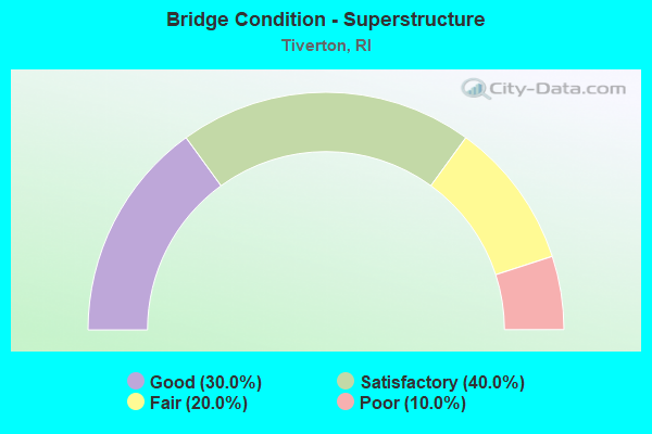
- Bridge Condition - Superstructure
- 30.0%Good
- 40.0%Satisfactory
- 20.0%Fair
- 10.0%Poor
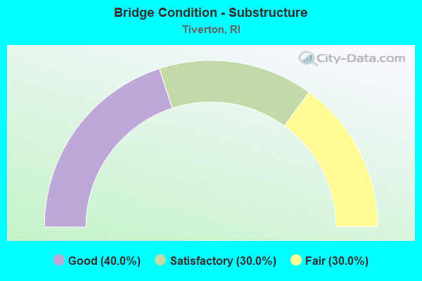
- Bridge Condition - Substructure
- 40.0%Good
- 30.0%Satisfactory
- 30.0%Fair
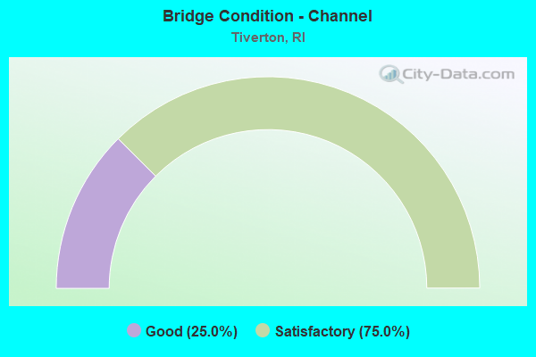
- Bridge Condition - Channel
- 25.0%Good
- 75.0%Satisfactory
Find on map >> Show street view
Structure Number: 126, Location: 0.05 Mi W of JCT RI 77 (Lat: 41.617647, Lng: -71.207033), Route carried "on" structure: City street , Year Built: 1958, Status: Posted for load, Structure Length: 5.55m (18.21ft), Average Daily Traffic: 1,115 (year 2021), Truck Traffic: 11%, Average Future Daily Traffic: 1,227 (year 2041), Design Load: HS 20, Features Intersected: NANAQUAKET RIVER, Facility Carried by Structure: NANAQUAKET RD
Minimum Vertical Clearance: 30+ m (98+ ft), Kilometerpoint: 2.589, Lanes on structure: 2, Owner: State Highway Agency, Approaching Roadway Width: 7.3m (24.0ft), Skew: 1 degrees, Material/Design: Prestressed concrete, Design/Construction: Box Beam or Girders - Multiple, Number Of Spans In Main Unit: 3, Length of Maximum Span: 18.5m (60.7ft), Curb or Sidewalk Widths: Left: 1.8m (5.9ft), Right: 0.8m (2.6ft), Curb-To-Curb Width: 7.3m (24.0ft), Out-to-Out Width: 10.5m (34.4ft)
Condition: Deck: Fair, Superstructure: Poor, Substructure: Satisfactory, Channel: Satisfactory, Operating Rating: 22.0 metric tons, Method Used To Determine Operating Rating: Load and Resistance Factor Rating (LRFR) rating reported by rating factor(RF) method using HL-93 loadings, Inventory Rating: 16.8 metric tons, Method Used To Determine Inventory Rating: Load and Resistance Factor Rating (LRFR) rating reported by rating factor(RF) method using HL-93 loadings, Structural Evaluation: Meets minimum limits, Deck Geometry: Meets minimum limits, Waterway Adequacy: Equal to present desirable criteria, Approach Roadway Alignment: Somewhat better than minimum adequacy, Bridge Posting: Required (Relationship of Operating Rating to Maximum Legal Load: 30.0 - 39.9% below), Length Of Structure Improvement: 5.49m (18.01ft), Designated Inspection Frequency: Every 24 months, Underwater Inspection Frequency: Every 48 months, Other Special Inspection Frequency: Every 12 months, Inspection Date: April 2021, Underwater Inspection Date: April 2021, Other Special Inspection Date: April 2021, Bridge Improvement Cost: $1,680,000, Roadway Improvement Cost: $168,000, Total Project Cost: $2,520,000, Deck Structure Type: Concrete Cast-file-Place, Wearing Surface/Protective System: Wearing Surface: Bituminous
Find on map >> Show street view
Structure Number: 284, Location: 0.4 Mi N of JCT RI 177 (Lat: 41.617875, Lng: -71.204414), Route carried "on" structure: State highway 77, Year Built: 1933, Status: Open, Structure Length: 0.73m (2.40ft), Average Daily Traffic: 6,868 (year 2014), Truck Traffic: 10%, Average Future Daily Traffic: 8,242 (year 2036), Design Load: H 20, Features Intersected: NANAQUAKET POND
Minimum Vertical Clearance: 30+ m (98+ ft), Kilometerpoint: 19.613, Lanes on structure: 2, Owner: State Highway Agency, Approaching Roadway Width: 15.2m (49.9ft), Material/Design: Concrete, Design/Construction: Slab, Number Of Spans In Main Unit: 1, Length of Maximum Span: 6.2m (20.3ft), Curb or Sidewalk Widths: Left: 0.0m, Right: 1.5m (4.9ft), Curb-To-Curb Width: 13.7m (44.9ft), Out-to-Out Width: 16.1m (52.8ft)
Condition: Deck: Good, Superstructure: Satisfactory, Substructure: Fair, Channel: Satisfactory, Operating Rating: 37.6 metric tons, Method Used To Determine Operating Rating: Load and Resistance Factor Rating (LRFR) rating reported by rating factor(RF) method using HL-93 loadings, Inventory Rating: 29.2 metric tons, Method Used To Determine Inventory Rating: Load and Resistance Factor Rating (LRFR) rating reported by rating factor(RF) method using HL-93 loadings, Structural Evaluation: Somewhat better than minimum adequacy, Deck Geometry: Superior to present desirable criteria, Waterway Adequacy: Equal to present minimum criteria, Approach Roadway Alignment: Equal to present minimum criteria, Length Of Structure Improvement: 0.76m (2.49ft), Designated Inspection Frequency: Every 24 months, Underwater Inspection Frequency: Every 48 months, Inspection Date: April 2021, Underwater Inspection Date: April 2021, Bridge Improvement Cost: $254,000, Roadway Improvement Cost: $25,000, Total Project Cost: $381,000, Deck Structure Type: Concrete Cast-file-Place, Wearing Surface/Protective System: Wearing Surface: Bituminous, Membrane: Other
Find on map >> Show street view
Structure Number: 291, Location: 1.4 Mi W of JCT RI 77 (Lat: 41.581922, Lng: -71.208936), Route carried "on" structure: City street , Year Built: 1994, Status: Open, Structure Length: 1.70m (5.58ft), Average Daily Traffic: 685 (year 2021), Truck Traffic: 10%, Average Future Daily Traffic: 754 (year 2041), Design Load: HS 20, Features Intersected: TIDAL INLET, Facility Carried by Structure: SEAPOWET AV
Minimum Vertical Clearance: 30+ m (98+ ft), Kilometerpoint: 2.276, Lanes on structure: 2, Owner: Town or Township Highway Agency, Approaching Roadway Width: 6.1m (20.0ft), Material/Design: Wood or Timber, Design/Construction: Stringer/Multi-beam, Number Of Spans In Main Unit: 1, Length of Maximum Span: 15.2m (49.9ft), Curb or Sidewalk Widths: Left: 0.3m (1.0ft), Right: 0.3m (1.0ft), Curb-To-Curb Width: 6.1m (20.0ft), Out-to-Out Width: 6.7m (22.0ft)
Condition: Deck: Good, Superstructure: Good, Substructure: Good, Channel: Good, Operating Rating: 35.3 metric tons, Method Used To Determine Operating Rating: Load and Resistance Factor Rating (LRFR) rating reported by rating factor(RF) method using HL-93 loadings, Inventory Rating: 27.2 metric tons, Method Used To Determine Inventory Rating: Load and Resistance Factor Rating (LRFR) rating reported by rating factor(RF) method using HL-93 loadings, Structural Evaluation: Equal to present minimum criteria, Deck Geometry: High priority of corrective action, Waterway Adequacy: Equal to present minimum criteria, Approach Roadway Alignment: Equal to present minimum criteria, Length Of Structure Improvement: 1.92m (6.30ft), Designated Inspection Frequency: Every 24 months, Underwater Inspection Frequency: Every 48 months, Inspection Date: April 2021, Underwater Inspection Date: April 2021, Bridge Improvement Cost: $843,000, Roadway Improvement Cost: $84,000, Total Project Cost: $1,264,000, Deck Structure Type: Wood or Timber, Wearing Surface/Protective System: Wearing Surface: Bituminous, Membrane: Other
Find on map >> Show street view
Structure Number: 3, Location: 0.8 Mi S of JCT RI 138 (Lat: 41.639794, Lng: -71.257881), Route carried "on" structure: State highway 114, Year Built: 1929, Year Reconstructed: 1985, Status: Open, Structure Length: 148.07m (485.79ft), Average Daily Traffic: 18,924 (year 2021), Truck Traffic: 6%, Average Future Daily Traffic: 20,816 (year 2041), Design Load: HS 20, Features Intersected: MT HP BY,N SEC RR,114 LP
Minimum Vertical Clearance: 5.18m (16.99ft), Kilometerpoint: 16.110, Lanes on structure: 2, Lanes under structure: 2, Base Highway Network: Yes, Owner: State Toll Authority, Approaching Roadway Width: 12.2m (40.0ft), Navigation Control: Yes ( Vertical Clearance: 30.2m (99.1ft), Horizontal Clearance: 30.2m (99.1ft)), Material/Design: Steel, Design/Construction: Suspension, Number Of Spans In Main Unit: 3, Number Of Approach Spans: 28, Length of Maximum Span: 365.8m (1,200.1ft), Curb or Sidewalk Widths: Left: 0.7m (2.3ft), Right: 0.7m (2.3ft), Curb-To-Curb Width: 8.2m (26.9ft), Out-to-Out Width: 9.7m (31.8ft)
Condition: Deck: Satisfactory, Superstructure: Satisfactory, Substructure: Fair, Channel: Satisfactory, Operating Rating: 26.2 metric tons, Method Used To Determine Operating Rating: Load and Resistance Factor Rating (LRFR) rating reported by rating factor(RF) method using HL-93 loadings, Inventory Rating: 20.1 metric tons, Method Used To Determine Inventory Rating: Load and Resistance Factor Rating (LRFR) rating reported by rating factor(RF) method using HL-93 loadings, Structural Evaluation: Somewhat better than minimum adequacy, Deck Geometry: High priority of corrective action, Underclear: Meets minimum limits, Waterway Adequacy: Superior to present desirable criteria, Approach Roadway Alignment: Equal to present minimum criteria, Length Of Structure Improvement: 148.07m (485.79ft), Designated Inspection Frequency: Every 24 months, Critical Feature Inspection Frequency: Every 24 months, Underwater Inspection Frequency: Every 48 months, Inspection Date: November 2020, Critical Feature Inspection Date: November 2020, Underwater Inspection Date: September 2021, Bridge Improvement Cost: $9,000,000, Roadway Improvement Cost: $900,000, Total Project Cost: $13,500,000, Deck Structure Type: Closed Grating, Wearing Surface/Protective System: Wearing Surface: Bituminous, Deck Protection: Other
Find on map >> Show street view
Structure Number: 648, Location: 4.0 Mi N of JCT RI 114 (Lat: 41.641033, Lng: -71.204264), Route carried "on" structure: State highway 138, Year Built: 2007, Status: Open, Structure Length: 4.55m (14.93ft), Average Daily Traffic: 12,522 (year 2021), Truck Traffic: 2%, Average Future Daily Traffic: 13,774 (year 2041), Design Load: HL 93, Features Intersected: RI 24
Minimum Vertical Clearance: 30+ m (98+ ft), Kilometerpoint: 74.099, Lanes on structure: 4, Lanes under structure: 4, Owner: State Highway Agency, Approaching Roadway Width: 17.7m (58.1ft), Skew: 4 degrees, Material/Design: Prestressed concrete continuous, Design/Construction: Box Beam or Girders - Single/Spread, Number Of Spans In Main Unit: 2, Length of Maximum Span: 24.4m (80.1ft), Curb or Sidewalk Widths: Left: 1.5m (4.9ft), Right: 1.5m (4.9ft), Curb-To-Curb Width: 17.7m (58.1ft), Out-to-Out Width: 21.3m (69.9ft)
Condition: Deck: Good, Superstructure: Good, Substructure: Good, Operating Rating: 96.2 metric tons, Method Used To Determine Operating Rating: Load and Resistance Factor Rating (LRFR) rating reported by rating factor(RF) method using HL-93 loadings, Inventory Rating: 73.2 metric tons, Method Used To Determine Inventory Rating: Load and Resistance Factor Rating (LRFR) rating reported by rating factor(RF) method using HL-93 loadings, Structural Evaluation: Better than present minimum criteria, Deck Geometry: Somewhat better than minimum adequacy, Underclear: Meets minimum limits, Approach Roadway Alignment: Better than present minimum criteria, Length Of Structure Improvement: 3.60m (11.81ft), Designated Inspection Frequency: Every 24 months, Inspection Date: May 2021, Bridge Improvement Cost: $956,000, Roadway Improvement Cost: $96,000, Total Project Cost: $1,434,000, Deck Structure Type: Concrete Cast-file-Place, Wearing Surface/Protective System: Wearing Surface: Bituminous, Membrane: Preformed Fabric, Deck Protection: Epoxy Coated Reinforcing
Find on map >> Show street view
Structure Number: 649, Location: 0.8 Mi N of JCT RI 138 (Lat: 41.641303, Lng: -71.187361), Route carried "on" structure: State highway 24, Year Built: 1968, Year Reconstructed: 1989, Status: Open, Structure Length: 2.74m (8.99ft), Average Daily Traffic: 16,298 (year 2015), Truck Traffic: 10%, Average Future Daily Traffic: 19,558 (year 2036), Design Load: HS 20+Mod, Features Intersected: EIGHT ROD WAY-FISH RD
Minimum Vertical Clearance: 30+ m (98+ ft), Kilometerpoint: 9.279, Lanes on structure: 2, Lanes under structure: 4, Owner: State Highway Agency, Approaching Roadway Width: 11.3m (37.1ft), Material/Design: Steel, Design/Construction: Stringer/Multi-beam, Number Of Spans In Main Unit: 1, Length of Maximum Span: 25.9m (85.0ft), Curb or Sidewalk Widths: Left: 0.6m (2.0ft), Right: 0.6m (2.0ft), Curb-To-Curb Width: 11.3m (37.1ft), Out-to-Out Width: 13.1m (43.0ft)
Condition: Deck: Satisfactory, Superstructure: Fair, Substructure: Fair, Operating Rating: 32.1 metric tons, Method Used To Determine Operating Rating: Load and Resistance Factor Rating (LRFR) rating reported by rating factor(RF) method using HL-93 loadings, Inventory Rating: 24.9 metric tons, Method Used To Determine Inventory Rating: Load and Resistance Factor Rating (LRFR) rating reported by rating factor(RF) method using HL-93 loadings, Structural Evaluation: Somewhat better than minimum adequacy, Deck Geometry: Somewhat better than minimum adequacy, Underclear: High priority of corrective action, Approach Roadway Alignment: Equal to present desirable criteria, Length Of Structure Improvement: 3.29m (10.79ft), Designated Inspection Frequency: Every 24 months, Inspection Date: April 2021, Bridge Improvement Cost: $897,000, Roadway Improvement Cost: $90,000, Total Project Cost: $1,345,000, Deck Structure Type: Concrete Cast-file-Place, Wearing Surface/Protective System: Wearing Surface: Bituminous, Membrane: Built-up
Find on map >> Show street view
Structure Number: 6492, Location: 0.8 Mi N of JCT RI 138 (Lat: 41.641494, Lng: -71.187356), Route carried "on" structure: State highway 24, Year Built: 1968, Year Reconstructed: 1989, Status: Open, Structure Length: 2.74m (8.99ft), Average Daily Traffic: 16,928 (year 1992), Truck Traffic: 10%, Average Future Daily Traffic: 20,314 (year 2036), Design Load: HS 20+Mod, Features Intersected: EIGHT ROD WAY-FISH RD
Minimum Vertical Clearance: 30+ m (98+ ft), Kilometerpoint: 3.449, Lanes on structure: 2, Lanes under structure: 4, Owner: State Highway Agency, Approaching Roadway Width: 11.3m (37.1ft), Material/Design: Steel, Design/Construction: Stringer/Multi-beam, Number Of Spans In Main Unit: 1, Length of Maximum Span: 26.7m (87.6ft), Curb or Sidewalk Widths: Left: 0.6m (2.0ft), Right: 0.6m (2.0ft), Curb-To-Curb Width: 11.3m (37.1ft), Out-to-Out Width: 13.1m (43.0ft)
Condition: Deck: Satisfactory, Superstructure: Fair, Substructure: Satisfactory, Operating Rating: 43.4 metric tons, Method Used To Determine Operating Rating: Load and Resistance Factor Rating (LRFR) rating reported by rating factor(RF) method using HL-93 loadings, Inventory Rating: 33.7 metric tons, Method Used To Determine Inventory Rating: Load and Resistance Factor Rating (LRFR) rating reported by rating factor(RF) method using HL-93 loadings, Structural Evaluation: Somewhat better than minimum adequacy, Deck Geometry: Somewhat better than minimum adequacy, Underclear: Meets minimum limits, Approach Roadway Alignment: Equal to present desirable criteria, Length Of Structure Improvement: 3.29m (10.79ft), Designated Inspection Frequency: Every 24 months, Inspection Date: April 2021, Bridge Improvement Cost: $897,000, Roadway Improvement Cost: $90,000, Total Project Cost: $1,345,000, Deck Structure Type: Concrete Cast-file-Place, Wearing Surface/Protective System: Wearing Surface: Bituminous, Membrane: Built-up
Find on map >> Show street view
Structure Number: 65, Location: 1.0 Mi S of Mass Line (Lat: 41.653428, Lng: -71.171561), Route carried "on" structure: State highway 24, Year Built: 1968, Year Reconstructed: 1989, Status: Open, Structure Length: 2.69m (8.83ft), Average Daily Traffic: 16,774 (year 2015), Truck Traffic: 1%, Average Future Daily Traffic: 20,129 (year 2036), Design Load: HS 20+Mod, Features Intersected: EAGLEVILLE RD
Minimum Vertical Clearance: 30+ m (98+ ft), Kilometerpoint: 11.288, Lanes on structure: 2, Lanes under structure: 2, Owner: State Highway Agency, Approaching Roadway Width: 11.3m (37.1ft), Skew: 2 degrees, Material/Design: Steel, Design/Construction: Stringer/Multi-beam, Number Of Spans In Main Unit: 1, Length of Maximum Span: 26.1m (85.6ft), Curb or Sidewalk Widths: Left: 0.6m (2.0ft), Right: 0.6m (2.0ft), Curb-To-Curb Width: 11.3m (37.1ft), Out-to-Out Width: 13.1m (43.0ft)
Condition: Deck: Satisfactory, Superstructure: Satisfactory, Substructure: Satisfactory, Operating Rating: 69.7 metric tons, Method Used To Determine Operating Rating: Load and Resistance Factor Rating (LRFR) rating reported by rating factor(RF) method using HL-93 loadings, Inventory Rating: 53.8 metric tons, Method Used To Determine Inventory Rating: Load and Resistance Factor Rating (LRFR) rating reported by rating factor(RF) method using HL-93 loadings, Structural Evaluation: Equal to present minimum criteria, Deck Geometry: Somewhat better than minimum adequacy, Underclear: High priority of corrective action, Approach Roadway Alignment: Equal to present desirable criteria, Length Of Structure Improvement: 3.32m (10.89ft), Designated Inspection Frequency: Every 24 months, Inspection Date: April 2021, Bridge Improvement Cost: $913,000, Roadway Improvement Cost: $91,000, Total Project Cost: $1,369,000, Deck Structure Type: Concrete Cast-file-Place, Wearing Surface/Protective System: Wearing Surface: Bituminous, Membrane: Built-up
Find on map >> Show street view
Structure Number: 1031, Location: .024mi W of jct Main rd (Lat: 41.638900, Lng: -71.207800), Route carried "on" structure: State highway 24, Year Built: 2012, Status: Open, Structure Length: 3.37m (11.06ft), Average Daily Traffic: 43,260 (year 2007), Truck Traffic: 3%, Average Future Daily Traffic: 51,912 (year 2036), Design Load: HS 25 or greater, Features Intersected: EVANS AVENUE
Minimum Vertical Clearance: 30+ m (98+ ft), Kilometerpoint: 7.263, Lanes on structure: 4, Lanes under structure: 2, Base Highway Network: Yes, Owner: State Toll Authority, Approaching Roadway Width: 25.6m (84.0ft), Skew: 30 degrees, Material/Design: Prestressed concrete, Design/Construction: Box Beam or Girders - Single/Spread, Number Of Spans In Main Unit: 1, Length of Maximum Span: 32.0m (105.0ft), Curb-To-Curb Width: 25.6m (84.0ft), Out-to-Out Width: 26.8m (87.9ft)
Condition: Deck: Good, Superstructure: Satisfactory, Substructure: Good, Operating Rating: 40.5 metric tons, Method Used To Determine Operating Rating: Load and Resistance Factor Rating (LRFR) rating reported by rating factor(RF) method using HL-93 loadings, Inventory Rating: 34.3 metric tons, Method Used To Determine Inventory Rating: Load and Resistance Factor Rating (LRFR) rating reported by rating factor(RF) method using HL-93 loadings, Structural Evaluation: Equal to present minimum criteria, Deck Geometry: Superior to present desirable criteria, Underclear: High priority of corrective action, Approach Roadway Alignment: Equal to present desirable criteria, Designated Inspection Frequency: Every 24 months, Inspection Date: August 2020, Deck Structure Type: Concrete Cast-file-Place, Wearing Surface/Protective System: Wearing Surface: Bituminous, Membrane: Epoxy, Deck Protection: Galvanized Reinforcing
Find on map >> Show street view
Structure Number: 1178, Location: 0.5 Mi W of Jct Main Rd (Lat: 41.646147, Lng: -71.208219), Route carried "on" structure: City street , Year Built: 2008, Status: Open, Structure Length: 1.40m (4.59ft), Average Daily Traffic: 922 (year 2021), Truck Traffic: 8%, Average Future Daily Traffic: 1,014 (year 2041), Design Load: HS 25 or greater, Features Intersected: Newport Secondary RR, Facility Carried by Structure: Schooner Drive
Minimum Vertical Clearance: 30.45m (99.90ft), Kilometerpoint: 0.597, Lanes on structure: 2, Owner: Town or Township Highway Agency, Approaching Roadway Width: 7.9m (25.9ft), Material/Design: Steel, Design/Construction: Truss - Thru, Number Of Spans In Main Unit: 1, Length of Maximum Span: 14.0m (45.9ft), Curb or Sidewalk Widths: Left: 0.0m, Right: 1.5m (4.9ft), Curb-To-Curb Width: 7.6m (24.9ft), Out-to-Out Width: 9.4m (30.8ft)
Condition: Deck: Good, Superstructure: Good, Substructure: Good, Operating Rating: 43.1 metric tons, Method Used To Determine Operating Rating: Load and Resistance Factor Rating (LRFR) rating reported by rating factor(RF) method using HL-93 loadings, Inventory Rating: 33.0 metric tons, Method Used To Determine Inventory Rating: Load and Resistance Factor Rating (LRFR) rating reported by rating factor(RF) method using HL-93 loadings, Structural Evaluation: Better than present minimum criteria, Deck Geometry: Meets minimum limits, Approach Roadway Alignment: Somewhat better than minimum adequacy, Designated Inspection Frequency: Every 24 months, Critical Feature Inspection Frequency: Every 12 months, Inspection Date: October 2020, Critical Feature Inspection Date: October 2021, Deck Structure Type: Concrete Cast-file-Place, Wearing Surface/Protective System: Wearing Surface: Monolithic Concrete
Find on map >> Show street view
Structure Number: 3, Location: 0.8 Mi S of JCT RI 138 (Lat: 41.639794, Lng: -71.257881), Route carried "under" structure: Ramp State highway 114, Year Built: 1929, Structure Length: 0. m, Average Daily Traffic: 18,924 (year 2021), Truck Traffic: 6%, Features Intersected: MT HP BY,N SEC RR,114 LP
Minimum Vertical Clearance: 4.56m (14.96ft), Kilometerpoint: 0.000, Lanes on structure: 2, Lanes under structure: 2, Material/Design: Steel, Design/Construction: Suspension, Length of Maximum Span: 365.8m (1,200.1ft)
Find on map >> Show street view
Structure Number: 648, Location: 4.0 Mi N of JCT RI 114 (Lat: 41.641033, Lng: -71.204264), Route carried "under" structure: State highway 24, Year Built: 2007, Structure Length: 0. m, Average Daily Traffic: 34,500 (year 2021), Truck Traffic: 17%, Features Intersected: RI 24, Facility Carried by Structure: RI 138 MAIN RD
Minimum Vertical Clearance: 4.90m (16.08ft), Kilometerpoint: 0.000, Lanes on structure: 4, Lanes under structure: 4, Material/Design: Prestressed concrete continuous, Design/Construction: Box Beam or Girders - Single/Spread, Length of Maximum Span: 24.4m (80.1ft)
Find on map >> Show street view
Structure Number: 649, Location: 0.8 Mi N of JCT RI 138 (Lat: 41.641303, Lng: -71.187361), Route carried "under" structure: City street , Year Built: 1968, Structure Length: 0. m, Average Daily Traffic: 1,000 (year 2008), Truck Traffic: 3%, Features Intersected: EIGHT ROD WAY-FISH RD, Facility Carried by Structure: RI 24 NB
Minimum Vertical Clearance: 4.44m (14.57ft), Kilometerpoint: 0.000, Lanes on structure: 2, Lanes under structure: 4, Material/Design: Steel, Design/Construction: Stringer/Multi-beam, Length of Maximum Span: 25.9m (85.0ft)
Find on map >> Show street view
Structure Number: 6492, Location: 0.8 Mi N of JCT RI 138 (Lat: 41.641494, Lng: -71.187356), Route carried "under" structure: City street , Year Built: 1968, Structure Length: 0. m, Average Daily Traffic: 1,000 (year 2008), Truck Traffic: 3%, Features Intersected: EIGHT ROD WAY-FISH RD, Facility Carried by Structure: RI 24 SB
Minimum Vertical Clearance: 4.29m (14.07ft), Kilometerpoint: 0.000, Lanes on structure: 2, Lanes under structure: 4, Material/Design: Steel, Design/Construction: Stringer/Multi-beam, Length of Maximum Span: 26.7m (87.6ft)
Find on map >> Show street view
Structure Number: 65, Location: 1.0 Mi S of Mass Line (Lat: 41.653428, Lng: -71.171561), Route carried "under" structure: City street , Year Built: 1968, Structure Length: 0. m, Average Daily Traffic: 1,000 (year 2008), Truck Traffic: 3%, Features Intersected: EAGLEVILLE RD, Facility Carried by Structure: RI 24 NB
Minimum Vertical Clearance: 4.24m (13.91ft), Kilometerpoint: 0.000, Lanes on structure: 2, Lanes under structure: 2, Material/Design: Steel, Design/Construction: Stringer/Multi-beam, Length of Maximum Span: 26.1m (85.6ft)
Find on map >> Show street view
Structure Number: 6502, Location: 1.0 Mi S of Mass Line (Lat: 41.653456, Lng: -71.171964), Route carried "under" structure: City street , Year Built: 1968, Structure Length: 0. m, Average Daily Traffic: 1,000 (year 2008), Truck Traffic: 3%, Features Intersected: EAGLEVILLE RD, Facility Carried by Structure: RI 24 SB
Minimum Vertical Clearance: 4.24m (13.91ft), Kilometerpoint: 0.000, Lanes on structure: 2, Lanes under structure: 2, Material/Design: Steel, Design/Construction: Stringer/Multi-beam, Length of Maximum Span: 26.1m (85.6ft)
Find on map >> Show street view
Structure Number: 1031, Location: .024mi W of jct Main rd (Lat: 41.638900, Lng: -71.207800), Route carried "under" structure: Bypass City street , Year Built: 2012, Structure Length: 0. m, Average Daily Traffic: 1,300 (year 2018), Truck Traffic: 2%, Features Intersected: EVANS AVENUE, Facility Carried by Structure: RI 24
Minimum Vertical Clearance: 4.32m (14.17ft), Kilometerpoint: 0.000, Lanes on structure: 4, Lanes under structure: 2, Material/Design: Prestressed concrete, Design/Construction: Box Beam or Girders - Single/Spread, Length of Maximum Span: 32.0m (105.0ft)