Bridge Statistics for Toad Hop, Indiana (IN)
Condition, Traffic, Stress, Structural Evaluation, Project Costs
- National Bridge Inventory (NBI) Statistics
- 16Number of bridges
- 174ft / 52.6mTotal length
- $1,006,000Total costs
- 127,450Total average daily traffic
- 35,516Total average daily truck traffic
- National Bridge Inventory (NBI) Registered Bridges for Toad Hop
- No street view available for this location
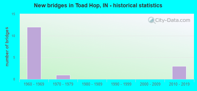
- New bridges - historical statistics
- 121960-1969
- 11970-1979
- 32010-2019
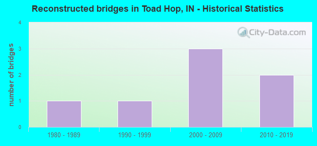
- Reconstructed bridges - Historical Statistics
- 11980-1989
- 11990-1999
- 32000-2009
- 22010-2019
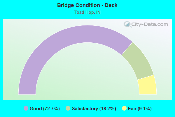
- Bridge Condition - Deck
- 72.7%Good
- 18.2%Satisfactory
- 9.1%Fair
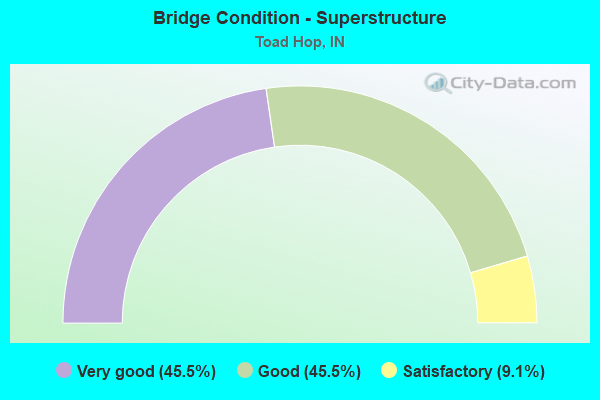
- Bridge Condition - Superstructure
- 45.5%Very good
- 45.5%Good
- 9.1%Satisfactory
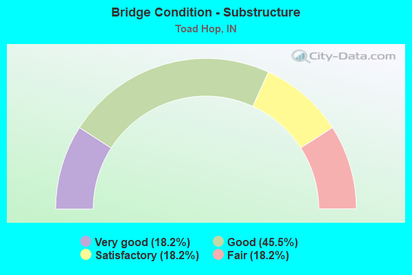
- Bridge Condition - Substructure
- 18.2%Very good
- 45.5%Good
- 18.2%Satisfactory
- 18.2%Fair
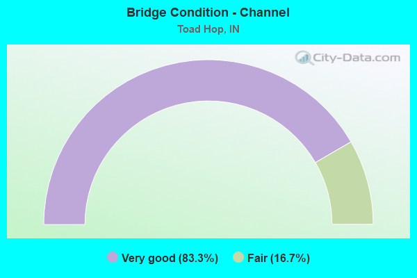
- Bridge Condition - Channel
- 83.3%Very good
- 16.7%Fair
Find on map >> Show street view
Structure Number: 4104, Location: 03.44 W US 41 (Lat: 39.448600, Lng: -87.469519), Route carried "on" structure: Alternate County highway , Year Built: 1964, Year Reconstructed: 1988, Status: Open, Structure Length: 7.22m (23.69ft), Average Daily Traffic: 5,426 (year 2004), Truck Traffic: 10%, Average Future Daily Traffic: 9,008 (year 2030), Design Load: HS 20, Features Intersected: I-70, Facility Carried by Structure: DARWIN ROAD
Minimum Vertical Clearance: 30+ m (98+ ft), Kilometerpoint: 0.000, Lanes on structure: 2, Lanes under structure: 4, Owner: State Highway Agency, Approaching Roadway Width: 8.5m (27.9ft), Skew: 2 degrees, Material/Design: Steel continuous, Design/Construction: Stringer/Multi-beam, Number Of Spans In Main Unit: 2, Number Of Approach Spans: 2, Length of Maximum Span: 21.9m (71.9ft), Curb-To-Curb Width: 9.8m (32.2ft), Out-to-Out Width: 10.8m (35.4ft)
Condition: Deck: Fair, Superstructure: Satisfactory, Substructure: Fair, Operating Rating: 57.4 metric tons, Method Used To Determine Operating Rating: Load Factor (LF), Inventory Rating: 34.4 metric tons, Method Used To Determine Inventory Rating: Load Factor (LF), Structural Evaluation: Somewhat better than minimum adequacy, Deck Geometry: Meets minimum limits, Underclear: Equal to present minimum criteria, Approach Roadway Alignment: Equal to present desirable criteria, Length Of Structure Improvement: 7.22m (23.69ft), Designated Inspection Frequency: Every 24 months, Inspection Date: January 2021, Bridge Improvement Cost: $1,006,000, Total Project Cost: $1,006,000, Deck Structure Type: Concrete Cast-file-Place, Wearing Surface/Protective System: Wearing Surface: Latex Concrete
Find on map >> Show street view
Structure Number: 13551, Location: 00.50 E I-70 (Lat: 39.446161, Lng: -87.501869), Route carried "on" structure: County highway , Year Built: 2015, Status: Open, Structure Length: 4.96m (16.27ft), Average Daily Traffic: 2,650 (year 2012), Truck Traffic: 4%, Average Future Daily Traffic: 2,860 (year 2032), Design Load: HL 93, Features Intersected: CLEAR CREEK, Facility Carried by Structure: OLD US 40 EB
Minimum Vertical Clearance: 30+ m (98+ ft), Kilometerpoint: 2.816, Lanes on structure: 2, Base Highway Network: Yes (, Subroute: 1), Owner: County Highway Agency, Approaching Roadway Width: 9.8m (32.2ft), Skew: 2 degrees, Material/Design: Prestressed concrete continuous, Design/Construction: Box Beam or Girders - Single/Spread, Number Of Spans In Main Unit: 3, Length of Maximum Span: 18.0m (59.1ft), Curb-To-Curb Width: 9.9m (32.5ft), Out-to-Out Width: 10.5m (34.4ft)
Condition: Deck: Good, Superstructure: Very good, Substructure: Good, Channel: Very good, Operating Rating: 62.5 metric tons, Method Used To Determine Operating Rating: Load and Resistance Factor Rating (LRFR) rating reported by rating factor(RF) method using HL-93 loadings, Inventory Rating: 48.3 metric tons, Method Used To Determine Inventory Rating: Load and Resistance Factor Rating (LRFR) rating reported by rating factor(RF) method using HL-93 loadings, Structural Evaluation: Better than present minimum criteria, Deck Geometry: High priority of replacement, Waterway Adequacy: Superior to present desirable criteria, Approach Roadway Alignment: Equal to present desirable criteria, Designated Inspection Frequency: Every 24 months, Inspection Date: April 2020, Deck Structure Type: Concrete Cast-file-Place, Wearing Surface/Protective System: Wearing Surface: Monolithic Concrete, Deck Protection: Epoxy Coated Reinforcing
Find on map >> Show street view
Structure Number: 13561, Location: 00.50 E I-70 (Lat: 39.446339, Lng: -87.502039), Route carried "on" structure: County highway , Year Built: 2015, Status: Open, Structure Length: 4.96m (16.27ft), Average Daily Traffic: 2,550 (year 2012), Truck Traffic: 4%, Average Future Daily Traffic: 2,750 (year 2032), Design Load: HL 93, Features Intersected: CLEAR CREEK, Facility Carried by Structure: OLD US 40 WBL
Minimum Vertical Clearance: 30+ m (98+ ft), Kilometerpoint: 2.816, Lanes on structure: 2, Base Highway Network: Yes (, Subroute: 1), Owner: County Highway Agency, Approaching Roadway Width: 9.8m (32.2ft), Skew: 2 degrees, Material/Design: Prestressed concrete continuous, Design/Construction: Box Beam or Girders - Single/Spread, Number Of Spans In Main Unit: 3, Length of Maximum Span: 18.0m (59.1ft), Curb-To-Curb Width: 9.9m (32.5ft), Out-to-Out Width: 10.5m (34.4ft)
Condition: Deck: Good, Superstructure: Very good, Substructure: Good, Channel: Very good, Operating Rating: 64.2 metric tons, Method Used To Determine Operating Rating: Load and Resistance Factor Rating (LRFR) rating reported by rating factor(RF) method using HL-93 loadings, Inventory Rating: 49.2 metric tons, Method Used To Determine Inventory Rating: Load and Resistance Factor Rating (LRFR) rating reported by rating factor(RF) method using HL-93 loadings, Structural Evaluation: Better than present minimum criteria, Deck Geometry: High priority of replacement, Waterway Adequacy: Superior to present desirable criteria, Approach Roadway Alignment: Equal to present desirable criteria, Designated Inspection Frequency: Every 24 months, Inspection Date: April 2020, Deck Structure Type: Concrete Cast-file-Place, Wearing Surface/Protective System: Wearing Surface: Monolithic Concrete, Deck Protection: Epoxy Coated Reinforcing
Find on map >> Show street view
Structure Number: 41, Location: 06.01 W US 41 (Lat: 39.439661, Lng: -87.517461), Route carried "on" structure: Interstate 70, Year Built: 1964, Year Reconstructed: 2002, Status: Open, Structure Length: 3.44m (11.29ft), Average Daily Traffic: 11,670 (year 2008), Truck Traffic: 50%, Average Future Daily Traffic: 18,088 (year 2034), Design Load: HS 20, Features Intersected: ROBINSON ROAD
Minimum Vertical Clearance: 30+ m (98+ ft), Kilometerpoint: 1.336, Lanes on structure: 2, Lanes under structure: 2, Base Highway Network: Yes (, Subroute: 1), Owner: State Highway Agency, Approaching Roadway Width: 11.6m (38.1ft), Material/Design: Concrete continuous, Design/Construction: Stringer/Multi-beam, Number Of Spans In Main Unit: 3, Length of Maximum Span: 11.1m (36.4ft), Curb-To-Curb Width: 14.1m (46.3ft), Out-to-Out Width: 15.1m (49.5ft)
Condition: Deck: Good, Superstructure: Good, Substructure: Fair, Operating Rating: 42.4 metric tons, Method Used To Determine Operating Rating: Load and Resistance Factor Rating (LRFR) rating reported by rating factor(RF) method using HL-93 loadings, Inventory Rating: 32.7 metric tons, Method Used To Determine Inventory Rating: Load and Resistance Factor Rating (LRFR) rating reported by rating factor(RF) method using HL-93 loadings, Structural Evaluation: Somewhat better than minimum adequacy, Deck Geometry: Superior to present desirable criteria, Underclear: Meets minimum limits, Approach Roadway Alignment: Equal to present desirable criteria, Designated Inspection Frequency: Every 24 months, Inspection Date: June 2020, Deck Structure Type: Concrete Cast-file-Place, Wearing Surface/Protective System: Wearing Surface: Latex Concrete
Find on map >> Show street view
Structure Number: 4101, Location: 05.57 W US 41 (Lat: 39.441989, Lng: -87.509461), Route carried "on" structure: US 40, Year Built: 1964, Year Reconstructed: 2015, Status: Open, Structure Length: 5.99m (19.65ft), Average Daily Traffic: 1,230 (year 2014), Truck Traffic: 7%, Average Future Daily Traffic: 1,290 (year 2034), Design Load: H 20, Features Intersected: I-70 WB
Minimum Vertical Clearance: 30+ m (98+ ft), Kilometerpoint: 2.012, Lanes on structure: 2, Lanes under structure: 2, Base Highway Network: Yes (, Subroute: 1), Owner: State Highway Agency, Approaching Roadway Width: 10.2m (33.5ft), Skew: 4 degrees, Material/Design: Steel, Design/Construction: Stringer/Multi-beam, Number Of Spans In Main Unit: 3, Length of Maximum Span: 23.2m (76.1ft), Curb-To-Curb Width: 10.2m (33.5ft), Out-to-Out Width: 11.1m (36.4ft)
Condition: Deck: Satisfactory, Superstructure: Good, Substructure: Satisfactory, Operating Rating: 59.6 metric tons, Method Used To Determine Operating Rating: Load and Resistance Factor Rating (LRFR) rating reported by rating factor(RF) method using HL-93 loadings, Inventory Rating: 46.0 metric tons, Method Used To Determine Inventory Rating: Load and Resistance Factor Rating (LRFR) rating reported by rating factor(RF) method using HL-93 loadings, Structural Evaluation: Equal to present minimum criteria, Deck Geometry: Somewhat better than minimum adequacy, Underclear: Somewhat better than minimum adequacy, Approach Roadway Alignment: Equal to present desirable criteria, Designated Inspection Frequency: Every 24 months, Other Special Inspection Frequency: Every 60 months, Inspection Date: April 2020, Other Special Inspection Date: May 2017, Deck Structure Type: Concrete Cast-file-Place, Wearing Surface/Protective System: Wearing Surface: Latex Concrete
Find on map >> Show street view
Structure Number: 4102, Location: 04.88 W US 41 (Lat: 39.444000, Lng: -87.495789), Route carried "on" structure: Interstate 70, Year Built: 1964, Year Reconstructed: 2014, Status: Open, Structure Length: 5.45m (17.88ft), Average Daily Traffic: 10,845 (year 2010), Truck Traffic: 45%, Average Future Daily Traffic: 14,511 (year 2034), Design Load: HS 20+Mod, Features Intersected: CLEAR CREEK
Minimum Vertical Clearance: 30+ m (98+ ft), Kilometerpoint: 3.154, Lanes on structure: 2, Base Highway Network: Yes (, Subroute: 1), Owner: State Highway Agency, Approaching Roadway Width: 12.2m (40.0ft), Skew: 1 degrees, Material/Design: Steel continuous, Design/Construction: Stringer/Multi-beam, Number Of Spans In Main Unit: 3, Length of Maximum Span: 20.1m (65.9ft), Curb-To-Curb Width: 12.3m (40.4ft), Out-to-Out Width: 13.2m (43.3ft)
Condition: Deck: Good, Superstructure: Good, Substructure: Good, Channel: Very good, Operating Rating: 76.0 metric tons, Method Used To Determine Operating Rating: Load Factor (LF), Inventory Rating: 45.5 metric tons, Method Used To Determine Inventory Rating: Load Factor (LF), Structural Evaluation: Better than present minimum criteria, Deck Geometry: Better than present minimum criteria, Waterway Adequacy: Superior to present desirable criteria, Approach Roadway Alignment: Equal to present desirable criteria, Designated Inspection Frequency: Every 24 months, Inspection Date: June 2020, Deck Structure Type: Concrete Cast-file-Place, Wearing Surface/Protective System: Wearing Surface: Monolithic Concrete
Find on map >> Show street view
Structure Number: 4103, Location: 04.88 W US 41 (Lat: 39.444219, Lng: -87.495939), Route carried "on" structure: Interstate 70, Year Built: 1964, Year Reconstructed: 2015, Status: Open, Structure Length: 5.45m (17.88ft), Average Daily Traffic: 10,845 (year 2010), Truck Traffic: 45%, Average Future Daily Traffic: 19,640 (year 2030), Design Load: HS 20+Mod, Features Intersected: CLEAR CREEK
Minimum Vertical Clearance: 30+ m (98+ ft), Kilometerpoint: 3.154, Lanes on structure: 2, Base Highway Network: Yes (, Subroute: 1), Owner: State Highway Agency, Approaching Roadway Width: 11.6m (38.1ft), Skew: 1 degrees, Material/Design: Steel continuous, Design/Construction: Stringer/Multi-beam, Number Of Spans In Main Unit: 3, Length of Maximum Span: 20.1m (65.9ft), Curb-To-Curb Width: 11.8m (38.7ft), Out-to-Out Width: 12.7m (41.7ft)
Condition: Deck: Good, Superstructure: Good, Substructure: Very good, Channel: Very good, Operating Rating: 75.3 metric tons, Method Used To Determine Operating Rating: Load Factor (LF), Inventory Rating: 45.1 metric tons, Method Used To Determine Inventory Rating: Load Factor (LF), Structural Evaluation: Better than present minimum criteria, Deck Geometry: Equal to present minimum criteria, Waterway Adequacy: Superior to present desirable criteria, Approach Roadway Alignment: Equal to present desirable criteria, Designated Inspection Frequency: Every 24 months, Inspection Date: June 2020, Deck Structure Type: Concrete Cast-file-Place, Wearing Surface/Protective System: Wearing Surface: Monolithic Concrete
Find on map >> Show street view
Structure Number: 4105, Location: 02.95 W US 41 (Lat: 39.448469, Lng: -87.460669), Route carried "on" structure: Interstate 70, Year Built: 1963, Year Reconstructed: 2012, Status: Open, Structure Length: 5.62m (18.44ft), Average Daily Traffic: 12,050 (year 2010), Truck Traffic: 40%, Average Future Daily Traffic: 21,824 (year 2030), Design Load: HS 20+Mod, Features Intersected: ABANDONED RR, ACCESS ROA
Minimum Vertical Clearance: 30+ m (98+ ft), Kilometerpoint: 6.260, Lanes on structure: 2, Lanes under structure: 2, Base Highway Network: Yes (, Subroute: 1), Owner: State Highway Agency, Approaching Roadway Width: 11.6m (38.1ft), Material/Design: Steel continuous, Design/Construction: Stringer/Multi-beam, Number Of Spans In Main Unit: 4, Length of Maximum Span: 15.1m (49.5ft), Curb-To-Curb Width: 12.3m (40.4ft), Out-to-Out Width: 13.2m (43.3ft)
Condition: Deck: Good, Superstructure: Very good, Substructure: Good, Operating Rating: 52.5 metric tons, Method Used To Determine Operating Rating: Load and Resistance Factor Rating (LRFR) rating reported by rating factor(RF) method using HL-93 loadings, Inventory Rating: 40.5 metric tons, Method Used To Determine Inventory Rating: Load and Resistance Factor Rating (LRFR) rating reported by rating factor(RF) method using HL-93 loadings, Structural Evaluation: Better than present minimum criteria, Deck Geometry: Better than present minimum criteria, Underclear: Better than present minimum criteria, Approach Roadway Alignment: Equal to present desirable criteria, Designated Inspection Frequency: Every 24 months, Inspection Date: June 2020, Deck Structure Type: Concrete Cast-file-Place, Wearing Surface/Protective System: Wearing Surface: Monolithic Concrete, Deck Protection: Epoxy Coated Reinforcing
Find on map >> Show street view
Structure Number: 4106, Location: 02.95 W US 41 (Lat: 39.448789, Lng: -87.460619), Route carried "on" structure: Interstate 70, Year Built: 1963, Year Reconstructed: 2011, Status: Open, Structure Length: 5.62m (18.44ft), Average Daily Traffic: 12,050 (year 2010), Truck Traffic: 40%, Average Future Daily Traffic: 18,800 (year 2030), Design Load: HS 20+Mod, Features Intersected: ABANDONED RR, ACCESS ROA
Minimum Vertical Clearance: 30+ m (98+ ft), Kilometerpoint: 6.260, Lanes on structure: 2, Lanes under structure: 2, Base Highway Network: Yes (, Subroute: 1), Owner: State Highway Agency, Approaching Roadway Width: 11.6m (38.1ft), Material/Design: Steel continuous, Design/Construction: Stringer/Multi-beam, Number Of Spans In Main Unit: 4, Length of Maximum Span: 15.1m (49.5ft), Curb-To-Curb Width: 12.3m (40.4ft), Out-to-Out Width: 13.2m (43.3ft)
Condition: Deck: Satisfactory, Superstructure: Very good, Substructure: Good, Operating Rating: 52.5 metric tons, Method Used To Determine Operating Rating: Load and Resistance Factor Rating (LRFR) rating reported by rating factor(RF) method using HL-93 loadings, Inventory Rating: 40.5 metric tons, Method Used To Determine Inventory Rating: Load and Resistance Factor Rating (LRFR) rating reported by rating factor(RF) method using HL-93 loadings, Structural Evaluation: Better than present minimum criteria, Deck Geometry: Better than present minimum criteria, Underclear: Better than present minimum criteria, Approach Roadway Alignment: Equal to present desirable criteria, Designated Inspection Frequency: Every 24 months, Inspection Date: June 2020, Deck Structure Type: Concrete Cast-file-Place, Wearing Surface/Protective System: Wearing Surface: Monolithic Concrete, Deck Protection: Epoxy Coated Reinforcing
Find on map >> Show street view
Structure Number: 8400102, Location: 00.70 W SANDFORD (Lat: 39.480150, Lng: -87.500600), Route carried "on" structure: County highway , Year Built: 1971, Status: Open, Structure Length: 1.83m (6.00ft), Average Daily Traffic: 1,887 (year 2017), Truck Traffic: 3%, Average Future Daily Traffic: 2,515 (year 2037), Features Intersected: West Little SUGAR CREEK, Facility Carried by Structure: Old PARIS Rd
Minimum Vertical Clearance: 30+ m (98+ ft), Kilometerpoint: 0.000, Lanes on structure: 2, Owner: County Highway Agency, Approaching Roadway Width: 6.7m (22.0ft), Material/Design: Prestressed concrete, Design/Construction: Box Beam or Girders - Multiple, Number Of Spans In Main Unit: 1, Length of Maximum Span: 16.8m (55.1ft), Curb or Sidewalk Widths: Left: 0.3m (1.0ft), Right: 0.3m (1.0ft), Curb-To-Curb Width: 8.6m (28.2ft), Out-to-Out Width: 9.2m (30.2ft)
Condition: Deck: Good, Superstructure: Good, Substructure: Satisfactory, Channel: Fair, Operating Rating: 59.9 metric tons, Method Used To Determine Operating Rating: Load Factor (LF), Inventory Rating: 35.9 metric tons, Method Used To Determine Inventory Rating: Load Factor (LF), Structural Evaluation: Equal to present minimum criteria, Deck Geometry: Somewhat better than minimum adequacy, Waterway Adequacy: Equal to present minimum criteria, Approach Roadway Alignment: Equal to present desirable criteria, Designated Inspection Frequency: Every 24 months, Inspection Date: July 2021, Deck Structure Type: Concrete Precast Panels, Wearing Surface/Protective System: Wearing Surface: Bituminous
Find on map >> Show street view
Structure Number: 8400353, Location: 00.50 E MCCULOUGH (Lat: 39.437619, Lng: -87.493231), Route carried "on" structure: County highway , Year Built: 2018, Status: Open, Structure Length: 2.06m (6.76ft), Average Daily Traffic: 188 (year 2017), Truck Traffic: 2%, Average Future Daily Traffic: 251 (year 2037), Design Load: HL 93, Features Intersected: CLEAR CREEK, Facility Carried by Structure: COOK Rd
Minimum Vertical Clearance: 30+ m (98+ ft), Kilometerpoint: 0.000, Lanes on structure: 2, Owner: County Highway Agency, Approaching Roadway Width: 7.3m (24.0ft), Material/Design: Steel, Design/Construction: Stringer/Multi-beam, Number Of Spans In Main Unit: 1, Length of Maximum Span: 19.5m (64.0ft), Curb-To-Curb Width: 7.3m (24.0ft), Out-to-Out Width: 7.3m (24.0ft)
Condition: Deck: Good, Superstructure: Very good, Substructure: Very good, Channel: Very good, Operating Rating: 57.0 metric tons, Method Used To Determine Operating Rating: Load and Resistance Factor (LRFR), Inventory Rating: 44.0 metric tons, Method Used To Determine Inventory Rating: Load and Resistance Factor (LRFR), Structural Evaluation: Equal to present desirable criteria, Deck Geometry: Somewhat better than minimum adequacy, Waterway Adequacy: Better than present minimum criteria, Approach Roadway Alignment: Equal to present minimum criteria, Designated Inspection Frequency: Every 24 months, Inspection Date: July 2021, Deck Structure Type: Concrete Cast-file-Place, Wearing Surface/Protective System: Deck Protection: Epoxy Coated Reinforcing
Find on map >> Show street view
Structure Number: 4101, Location: 05.57 W US 41 (Lat: 39.441989, Lng: -87.509461), Route carried "under" structure: Interstate 70, Year Built: 1964, Structure Length: 0. m, Average Daily Traffic: 10,845 (year 2010), Truck Traffic: 45%, Features Intersected: I-70 WBL, Facility Carried by Structure: US 40 EB
Minimum Vertical Clearance: 5.16m (16.93ft), Kilometerpoint: 2.076, Lanes on structure: 2, Lanes under structure: 2, Material/Design: Steel, Design/Construction: Stringer/Multi-beam, Length of Maximum Span: 23.2m (76.1ft)
Find on map >> Show street view
Structure Number: 4104, Location: 03.44 W US 41 (Lat: 39.448511, Lng: -87.469550), Route carried "under" structure: Interstate 70, Year Built: 1964, Structure Length: 0. m, Average Daily Traffic: 22,532 (year 2004), Truck Traffic: 10%, Features Intersected: I-70 EBL, Facility Carried by Structure: DARWIN ROAD
Minimum Vertical Clearance: 5.08m (16.67ft), Kilometerpoint: 5.504, Lanes on structure: 2, Lanes under structure: 4, Material/Design: Steel continuous, Design/Construction: Stringer/Multi-beam, Length of Maximum Span: 21.9m (71.9ft)
Find on map >> Show street view
Structure Number: 4104, Location: 03.44 W US 41 (Lat: 39.448511, Lng: -87.469550), Route carried "under" structure: Interstate 70, Year Built: 1964, Structure Length: 0. m, Average Daily Traffic: 22,532 (year 2004), Truck Traffic: 10%, Features Intersected: I-70 WBL, Facility Carried by Structure: DARWIN ROAD
Minimum Vertical Clearance: 5.08m (16.67ft), Kilometerpoint: 5.504, Lanes on structure: 2, Lanes under structure: 4, Material/Design: Steel continuous, Design/Construction: Stringer/Multi-beam, Length of Maximum Span: 21.9m (71.9ft)
Find on map >> Show street view
Structure Number: 4105, Location: 02.95 W US 41 (Lat: 39.448469, Lng: -87.460617), Route carried "under" structure: County highway , Year Built: 1963, Structure Length: 0. m, Average Daily Traffic: 75 (year 2010), Truck Traffic: 1%, Features Intersected: ACCESS ROAD & ABAN RR, Facility Carried by Structure: I-70 EB
Minimum Vertical Clearance: 6.50m (21.33ft), Kilometerpoint: 0.000, Lanes on structure: 2, Lanes under structure: 2, Material/Design: Steel continuous, Design/Construction: Stringer/Multi-beam, Length of Maximum Span: 15.1m (49.5ft)
Find on map >> Show street view
Structure Number: 4106, Location: 02.95 W US 41 (Lat: 39.448719, Lng: -87.460617), Route carried "under" structure: County highway , Year Built: 1963, Structure Length: 0. m, Average Daily Traffic: 75 (year 2010), Truck Traffic: 1%, Features Intersected: ACCESS ROAD & ABAN RR, Facility Carried by Structure: I-70 WB
Minimum Vertical Clearance: 6.68m (21.92ft), Kilometerpoint: 0.000, Lanes on structure: 2, Lanes under structure: 2, Material/Design: Steel continuous, Design/Construction: Stringer/Multi-beam, Length of Maximum Span: 15.1m (49.5ft)