Bridge Statistics for Trimont, Minnesota (MN)
Condition, Traffic, Stress, Structural Evaluation, Project Costs
- National Bridge Inventory (NBI) Statistics
- 16Number of bridges
- 112ft / 34.1mTotal length
- $407,001,000Total costs
- 3,967Total average daily traffic
- 165Total average daily truck traffic
- 4,080Total future (year 2029) average daily traffic
- National Bridge Inventory (NBI) Registered Bridges for Trimont
- No street view available for this location
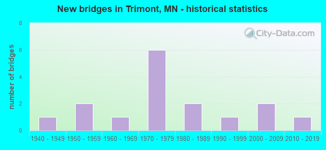
- New bridges - historical statistics
- 11940-1949
- 21950-1959
- 11960-1969
- 61970-1979
- 21980-1989
- 11990-1999
- 22000-2009
- 12010-2019
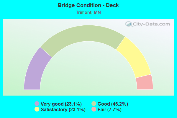
- Bridge Condition - Deck
- 23.1%Very good
- 46.2%Good
- 23.1%Satisfactory
- 7.7%Fair
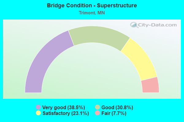
- Bridge Condition - Superstructure
- 38.5%Very good
- 30.8%Good
- 23.1%Satisfactory
- 7.7%Fair
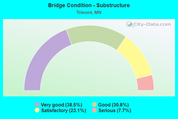
- Bridge Condition - Substructure
- 38.5%Very good
- 30.8%Good
- 23.1%Satisfactory
- 7.7%Serious
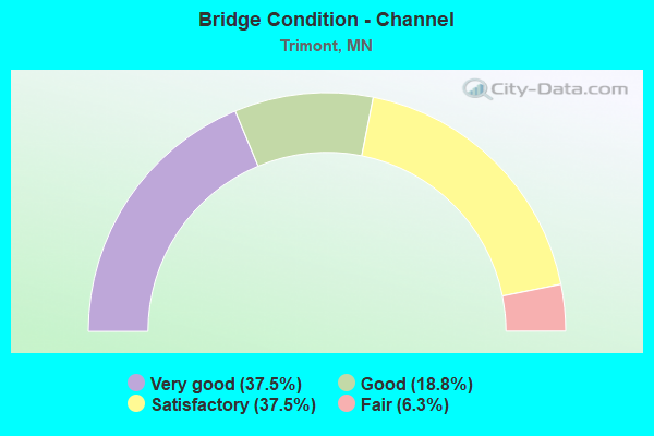
- Bridge Condition - Channel
- 37.5%Very good
- 18.8%Good
- 37.5%Satisfactory
- 6.3%Fair
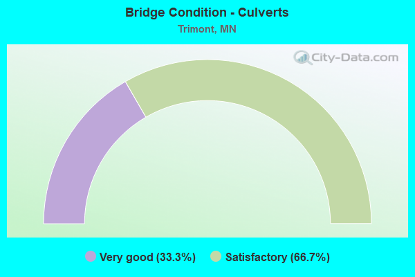
- Bridge Condition - Culverts
- 33.3%Very good
- 66.7%Satisfactory
Find on map >> Show street view
Structure Number: 46504, Location: 0.5 MI E OF JCT CSAH 21 (Lat: 43.732269, Lng: -94.656958), Route carried "on" structure: County highway 38, Year Built: 1964, Status: Posted for load, Structure Length: 2.85m (9.35ft), Average Daily Traffic: 710 (year 2014), Average Future Daily Traffic: 710 (year 2039), Design Load: H 20, Features Intersected: ELM CREEK
Minimum Vertical Clearance: 30+ m (98+ ft), Kilometerpoint: 0.000, Lanes on structure: 2, Owner: County Highway Agency, Approaching Roadway Width: 11.0m (36.1ft), Material/Design: Prestressed concrete, Design/Construction: Channel Beam, Number Of Spans In Main Unit: 3, Length of Maximum Span: 9.4m (30.8ft), Curb-To-Curb Width: 9.0m (29.5ft), Out-to-Out Width: 9.2m (30.2ft)
Condition: Deck: Fair, Superstructure: Fair, Substructure: Satisfactory, Channel: Very good, Operating Rating: 38.2 metric tons, Method Used To Determine Operating Rating: Load Factor (LF), Inventory Rating: 17.0 metric tons, Method Used To Determine Inventory Rating: Load Factor (LF), Structural Evaluation: Meets minimum limits, Deck Geometry: Somewhat better than minimum adequacy, Waterway Adequacy: Equal to present desirable criteria, Approach Roadway Alignment: Equal to present desirable criteria, Bridge Posting: Required (Relationship of Operating Rating to Maximum Legal Load: 0.1 - 9.9% below), Designated Inspection Frequency: Every 12 months, Inspection Date: October 2021, Deck Structure Type: Concrete Cast-file-Place, Wearing Surface/Protective System: Wearing Surface: Bituminous
Find on map >> Show street view
Structure Number: 46519, Location: 1.9 MI N OF JCT CSAH 36 (Lat: 43.746511, Lng: -94.794058), Route carried "on" structure: County highway 107, Year Built: 1975, Status: Open, Structure Length: 2.11m (6.92ft), Average Daily Traffic: 55 (year 2005), Average Future Daily Traffic: 55 (year 2029), Design Load: H 20, Features Intersected: CR.107 OVER ELM CREEK
Minimum Vertical Clearance: 30+ m (98+ ft), Kilometerpoint: 0.000, Lanes on structure: 2, Owner: County Highway Agency, Approaching Roadway Width: 7.9m (25.9ft), Skew: 3 degrees, Material/Design: Prestressed concrete, Design/Construction: Channel Beam, Number Of Spans In Main Unit: 3, Length of Maximum Span: 9.5m (31.2ft), Curb-To-Curb Width: 9.4m (30.8ft), Out-to-Out Width: 10.6m (34.8ft)
Condition: Deck: Good, Superstructure: Very good, Substructure: Good, Channel: Fair, Operating Rating: 65.1 metric tons, Method Used To Determine Operating Rating: Load Factor (LF), Inventory Rating: 39.0 metric tons, Method Used To Determine Inventory Rating: Load Factor (LF), Structural Evaluation: Better than present minimum criteria, Deck Geometry: Better than present minimum criteria, Waterway Adequacy: Equal to present desirable criteria, Approach Roadway Alignment: Equal to present desirable criteria, Designated Inspection Frequency: Every 24 months, Inspection Date: November 2020, Deck Structure Type: Concrete Cast-file-Place, Wearing Surface/Protective System: Wearing Surface: Bituminous
Find on map >> Show street view
Structure Number: 46528, Location: 1.2 MI E OF JCT CSAH 38 (Lat: 43.754131, Lng: -94.649219), Route carried "on" structure: County highway 18, Year Built: 1976, Status: Open, Structure Length: 2.56m (8.40ft), Average Daily Traffic: 49 (year 1986), Average Future Daily Traffic: 49 (year 2029), Design Load: H 20, Features Intersected: ELM CREEK
Minimum Vertical Clearance: 30+ m (98+ ft), Kilometerpoint: 0.000, Lanes on structure: 2, Owner: Town or Township Highway Agency, Approaching Roadway Width: 8.5m (27.9ft), Material/Design: Wood or Timber, Design/Construction: Slab, Number Of Spans In Main Unit: 3, Length of Maximum Span: 9.8m (32.2ft), Curb-To-Curb Width: 8.5m (27.9ft), Out-to-Out Width: 9.1m (29.9ft)
Condition: Deck: Very good, Superstructure: Very good, Substructure: Satisfactory, Channel: Very good, Operating Rating: 49.3 metric tons, Method Used To Determine Operating Rating: Allowable Stress (AS), Inventory Rating: 32.3 metric tons, Method Used To Determine Inventory Rating: Allowable Stress (AS), Structural Evaluation: Equal to present minimum criteria, Deck Geometry: Better than present minimum criteria, Waterway Adequacy: Equal to present desirable criteria, Approach Roadway Alignment: Equal to present desirable criteria, Designated Inspection Frequency: Every 24 months, Inspection Date: November 2020, Deck Structure Type: Wood or Timber, Wearing Surface/Protective System: Wearing Surface: Bituminous
Find on map >> Show street view
Structure Number: 46531, Location: 0.2 MI N OF JCT CSAH 38 (Lat: 43.764592, Lng: -94.694808), Route carried "on" structure: County highway 19, Year Built: 1978, Status: Open, Structure Length: 2.74m (8.99ft), Average Daily Traffic: 170 (year 2014), Average Future Daily Traffic: 170 (year 2039), Design Load: HS 20, Features Intersected: CEDAR RUN
Minimum Vertical Clearance: 30+ m (98+ ft), Kilometerpoint: 0.000, Lanes on structure: 2, Owner: County Highway Agency, Approaching Roadway Width: 9.8m (32.2ft), Material/Design: Prestressed concrete, Design/Construction: Tee Beam, Number Of Spans In Main Unit: 2, Length of Maximum Span: 13.3m (43.6ft), Curb-To-Curb Width: 11.2m (36.7ft), Out-to-Out Width: 12.2m (40.0ft)
Condition: Deck: Good, Superstructure: Very good, Substructure: Very good, Channel: Good, Operating Rating: 58.1 metric tons, Method Used To Determine Operating Rating: Load Factor (LF), Inventory Rating: 28.4 metric tons, Method Used To Determine Inventory Rating: Load Factor (LF), Structural Evaluation: Better than present minimum criteria, Deck Geometry: Superior to present desirable criteria, Waterway Adequacy: Superior to present desirable criteria, Approach Roadway Alignment: Equal to present desirable criteria, Designated Inspection Frequency: Every 24 months, Inspection Date: November 2020, Deck Structure Type: Concrete Cast-file-Place, Wearing Surface/Protective System: Wearing Surface: Bituminous
Find on map >> Show street view
Structure Number: 46542, Location: 1.5 MI S OF JCT CR 138 (Lat: 43.710708, Lng: -94.694539), Route carried "on" structure: County highway 12, Year Built: 1979, Status: Open, Structure Length: 3.63m (11.91ft), Average Daily Traffic: 26 (year 1986), Average Future Daily Traffic: 26 (year 2029), Design Load: HS 20, Features Intersected: ELM CREEK
Minimum Vertical Clearance: 30+ m (98+ ft), Kilometerpoint: 0.000, Lanes on structure: 2, Owner: Town or Township Highway Agency, Approaching Roadway Width: 8.5m (27.9ft), Skew: 2 degrees, Material/Design: Wood or Timber, Design/Construction: Slab, Number Of Spans In Main Unit: 4, Length of Maximum Span: 9.1m (29.9ft), Curb-To-Curb Width: 8.5m (27.9ft), Out-to-Out Width: 9.1m (29.9ft)
Condition: Deck: Satisfactory, Superstructure: Satisfactory, Substructure: Good, Channel: Satisfactory, Operating Rating: 62.0 metric tons, Method Used To Determine Operating Rating: Allowable Stress (AS), Inventory Rating: 43.7 metric tons, Method Used To Determine Inventory Rating: Allowable Stress (AS), Structural Evaluation: Equal to present minimum criteria, Deck Geometry: Better than present minimum criteria, Waterway Adequacy: Equal to present desirable criteria, Approach Roadway Alignment: Equal to present desirable criteria, Designated Inspection Frequency: Every 24 months, Inspection Date: November 2020, Deck Structure Type: Wood or Timber, Wearing Surface/Protective System: Wearing Surface: Bituminous
Find on map >> Show street view
Structure Number: 46546, Location: 0.5 MI E OF JCT CSAH 9 (Lat: 43.790672, Lng: -94.764406), Route carried "on" structure: County highway 174, Year Built: 1979, Status: Open, Structure Length: 2.19m (7.19ft), Average Daily Traffic: 12 (year 1986), Average Future Daily Traffic: 12 (year 2029), Design Load: HS 20, Features Intersected: CEDAR RUN
Minimum Vertical Clearance: 30+ m (98+ ft), Kilometerpoint: 0.000, Lanes on structure: 2, Owner: Town or Township Highway Agency, Approaching Roadway Width: 8.5m (27.9ft), Material/Design: Wood or Timber, Design/Construction: Slab, Number Of Spans In Main Unit: 3, Length of Maximum Span: 7.3m (24.0ft), Curb-To-Curb Width: 8.5m (27.9ft), Out-to-Out Width: 9.1m (29.9ft)
Condition: Deck: Good, Superstructure: Good, Substructure: Very good, Channel: Very good, Operating Rating: 58.4 metric tons, Method Used To Determine Operating Rating: Allowable Stress (AS), Inventory Rating: 41.5 metric tons, Method Used To Determine Inventory Rating: Allowable Stress (AS), Structural Evaluation: Better than present minimum criteria, Deck Geometry: Better than present minimum criteria, Waterway Adequacy: Equal to present desirable criteria, Approach Roadway Alignment: Equal to present desirable criteria, Designated Inspection Frequency: Every 24 months, Inspection Date: November 2020, Deck Structure Type: Wood or Timber, Wearing Surface/Protective System: Wearing Surface: Bituminous
Find on map >> Show street view
Structure Number: 46547, Location: 0.7 MI NE OF JCT CSAH 36 (Lat: 43.725150, Lng: -94.770686), Route carried "on" structure: County highway 180, Year Built: 1982, Status: Posted for load, Structure Length: 2.93m (9.61ft), Average Daily Traffic: 30 (year 1986), Average Future Daily Traffic: 30 (year 2029), Design Load: HS 20, Features Intersected: ELM CREEK
Minimum Vertical Clearance: 30+ m (98+ ft), Kilometerpoint: 0.000, Lanes on structure: 2, Owner: Town or Township Highway Agency, Approaching Roadway Width: 8.5m (27.9ft), Material/Design: Wood or Timber, Design/Construction: Slab, Number Of Spans In Main Unit: 3, Length of Maximum Span: 9.8m (32.2ft), Curb-To-Curb Width: 8.5m (27.9ft), Out-to-Out Width: 9.1m (29.9ft)
Condition: Deck: Good, Superstructure: Good, Substructure: Good, Channel: Satisfactory, Operating Rating: 38.8 metric tons, Method Used To Determine Operating Rating: Allowable Stress (AS), Inventory Rating: 25.1 metric tons, Method Used To Determine Inventory Rating: Allowable Stress (AS), Structural Evaluation: Equal to present minimum criteria, Deck Geometry: Better than present minimum criteria, Waterway Adequacy: Superior to present desirable criteria, Approach Roadway Alignment: Better than present minimum criteria, Bridge Posting: Required (Relationship of Operating Rating to Maximum Legal Load: 30.0 - 39.9% below), Designated Inspection Frequency: Every 24 months, Inspection Date: November 2020, Deck Structure Type: Wood or Timber, Wearing Surface/Protective System: Wearing Surface: Bituminous
Find on map >> Show street view
Structure Number: 46551, Location: 1.4 MI S OF JCT CR 138 (Lat: 43.713936, Lng: -94.714522), Route carried "on" structure: County highway 11, Year Built: 1979, Status: Open, Structure Length: 2.74m (8.99ft), Average Daily Traffic: 43 (year 1986), Average Future Daily Traffic: 43 (year 2029), Design Load: HS 20, Features Intersected: ELM CREEK
Minimum Vertical Clearance: 30+ m (98+ ft), Kilometerpoint: 0.000, Lanes on structure: 2, Owner: Town or Township Highway Agency, Approaching Roadway Width: 8.5m (27.9ft), Material/Design: Wood or Timber, Design/Construction: Slab, Number Of Spans In Main Unit: 3, Length of Maximum Span: 9.1m (29.9ft), Curb-To-Curb Width: 8.5m (27.9ft), Out-to-Out Width: 9.1m (29.9ft)
Condition: Deck: Satisfactory, Superstructure: Satisfactory, Substructure: Very good, Channel: Satisfactory, Operating Rating: 60.8 metric tons, Method Used To Determine Operating Rating: Allowable Stress (AS), Inventory Rating: 43.1 metric tons, Method Used To Determine Inventory Rating: Allowable Stress (AS), Structural Evaluation: Equal to present minimum criteria, Deck Geometry: Better than present minimum criteria, Waterway Adequacy: Superior to present desirable criteria, Approach Roadway Alignment: Equal to present desirable criteria, Designated Inspection Frequency: Every 24 months, Inspection Date: November 2020, Deck Structure Type: Wood or Timber, Wearing Surface/Protective System: Wearing Surface: Bituminous
Find on map >> Show street view
Structure Number: 46557, Location: 0.9 MI S OF JCT CSAH 40 (Lat: 43.739875, Lng: -94.774272), Route carried "on" structure: County highway 63, Year Built: 1986, Status: Posted for load, Structure Length: 2.19m (7.19ft), Average Daily Traffic: 12 (year 1986), Average Future Daily Traffic: 12 (year 2029), Design Load: HS 20, Features Intersected: ELM CREEK
Minimum Vertical Clearance: 30+ m (98+ ft), Kilometerpoint: 0.000, Lanes on structure: 2, Owner: Town or Township Highway Agency, Approaching Roadway Width: 6.7m (22.0ft), Material/Design: Wood or Timber, Design/Construction: Slab, Number Of Spans In Main Unit: 3, Length of Maximum Span: 7.3m (24.0ft), Curb-To-Curb Width: 8.6m (28.2ft), Out-to-Out Width: 9.1m (29.9ft)
Condition: Deck: Good, Superstructure: Good, Substructure: Good, Channel: Very good, Operating Rating: 50.0 metric tons, Method Used To Determine Operating Rating: Allowable Stress (AS), Inventory Rating: 34.9 metric tons, Method Used To Determine Inventory Rating: Allowable Stress (AS), Structural Evaluation: Better than present minimum criteria, Deck Geometry: Better than present minimum criteria, Waterway Adequacy: Superior to present desirable criteria, Approach Roadway Alignment: Equal to present desirable criteria, Designated Inspection Frequency: Every 24 months, Inspection Date: November 2020, Deck Structure Type: Wood or Timber, Wearing Surface/Protective System: Wearing Surface: Bituminous
Find on map >> Show street view
Structure Number: 46559, Location: 1.6 MI W OF JCT TH 4 (Lat: 43.718478, Lng: -94.761275), Route carried "on" structure: County highway 36, Year Built: 2005, Status: Open, Structure Length: 3.05m (10.01ft), Average Daily Traffic: 280 (year 2014), Average Future Daily Traffic: 280 (year 2039), Design Load: HS 25 or greater, Features Intersected: ELM CREEK
Minimum Vertical Clearance: 30+ m (98+ ft), Kilometerpoint: 0.000, Lanes on structure: 2, Owner: County Highway Agency, Approaching Roadway Width: 8.5m (27.9ft), Skew: 1 degrees, Material/Design: Prestressed concrete, Design/Construction: Stringer/Multi-beam, Number Of Spans In Main Unit: 1, Length of Maximum Span: 29.0m (95.1ft), Curb-To-Curb Width: 12.2m (40.0ft), Out-to-Out Width: 13.2m (43.3ft)
Condition: Deck: Very good, Superstructure: Very good, Substructure: Very good, Channel: Good, Operating Rating: 82.4 metric tons, Method Used To Determine Operating Rating: Load Factor (LF), Inventory Rating: 45.8 metric tons, Method Used To Determine Inventory Rating: Load Factor (LF), Structural Evaluation: Equal to present desirable criteria, Deck Geometry: Superior to present desirable criteria, Waterway Adequacy: Superior to present desirable criteria, Approach Roadway Alignment: Equal to present desirable criteria, Length Of Structure Improvement: 1.13m (3.71ft), Designated Inspection Frequency: Every 24 months, Inspection Date: November 2020, Bridge Improvement Cost: $429,000,000, Roadway Improvement Cost: $1,000, Total Project Cost: $1,000, Deck Structure Type: Concrete Cast-file-Place, Wearing Surface/Protective System: Wearing Surface: Monolithic Concrete, Deck Protection: Epoxy Coated Reinforcing
Find on map >> Show street view
Structure Number: 46569, Location: 1.7 MI E OF JCT CSAH 9 (Lat: 43.776375, Lng: -94.740250), Route carried "on" structure: County highway 44, Year Built: 2000, Status: Open, Structure Length: 1.10m (3.61ft), Average Daily Traffic: 550 (year 2014), Average Future Daily Traffic: 550 (year 2039), Design Load: HS 25 or greater, Features Intersected: CEDAR LAKE
Minimum Vertical Clearance: 30+ m (98+ ft), Kilometerpoint: 0.000, Lanes on structure: 2, Owner: County Highway Agency, Approaching Roadway Width: 10.8m (35.4ft), Material/Design: Concrete, Design/Construction: Slab, Number Of Spans In Main Unit: 1, Length of Maximum Span: 10.3m (33.8ft), Curb-To-Curb Width: 10.8m (35.4ft), Out-to-Out Width: 11.7m (38.4ft)
Condition: Deck: Very good, Superstructure: Very good, Substructure: Very good, Channel: Very good, Operating Rating: 66.5 metric tons, Method Used To Determine Operating Rating: Load Factor (LF), Inventory Rating: 39.8 metric tons, Method Used To Determine Inventory Rating: Load Factor (LF), Structural Evaluation: Equal to present desirable criteria, Deck Geometry: Equal to present minimum criteria, Waterway Adequacy: Superior to present desirable criteria, Approach Roadway Alignment: Equal to present desirable criteria, Designated Inspection Frequency: Every 24 months, Inspection Date: November 2020, Deck Structure Type: Concrete Cast-file-Place, Wearing Surface/Protective System: Wearing Surface: Monolithic Concrete, Deck Protection: Epoxy Coated Reinforcing
Find on map >> Show street view
Structure Number: 46J28, Location: 0.9 MI S OF JCT CSAH 44 (Lat: 43.763992, Lng: -94.654953), Route carried "on" structure: County highway 16, Year Built: 2010, Status: Open, Structure Length: 0.66m (2.17ft), Average Daily Traffic: 49 (year 2009), Average Future Daily Traffic: 49 (year 2029), Design Load: HS 25 or greater, Features Intersected: CEDAR RUN
Minimum Vertical Clearance: 30+ m (98+ ft), Kilometerpoint: 0.000, Lanes on structure: 2, Owner: Town or Township Highway Agency, Approaching Roadway Width: 7.3m (24.0ft), Material/Design: Concrete, Design/Construction: Culvert, Number Of Spans In Main Unit: 2, Length of Maximum Span: 3.0m (9.8ft)
Condition: Channel: Very good, Culverts: Very good, Operating Rating: 58.8 metric tons, Method Used To Determine Operating Rating: Assigned rating based on Load Factor Design (LFD) reported in metric tons, Inventory Rating: 39.2 metric tons, Method Used To Determine Inventory Rating: Assigned rating based on Load Factor Design (LFD) reported in metric tons, Structural Evaluation: Equal to present desirable criteria, Waterway Adequacy: Superior to present desirable criteria, Approach Roadway Alignment: Equal to present desirable criteria, Designated Inspection Frequency: Every 24 months, Inspection Date: November 2020
Find on map >> Show street view
Structure Number: 8567, Location: 0.8 MI N OF TRIMONT (Lat: 43.772692, Lng: -94.714594), Route carried "on" structure: State highway 4, Year Built: 1946, Status: Open, Structure Length: 0.79m (2.59ft), Average Daily Traffic: 1,837 (year 2019), Truck Traffic: 9%, Average Future Daily Traffic: 1,950 (year 2039), Design Load: H 15, Features Intersected: CEDAR RUN
Minimum Vertical Clearance: 30+ m (98+ ft), Kilometerpoint: 0.000, Lanes on structure: 2, Base Highway Network: Yes, Owner: State Highway Agency, Approaching Roadway Width: 10.4m (34.1ft), Material/Design: Concrete, Design/Construction: Culvert, Number Of Spans In Main Unit: 2, Length of Maximum Span: 3.8m (12.5ft)
Condition: Channel: Satisfactory, Culverts: Satisfactory, Operating Rating: 39.2 metric tons, Method Used To Determine Operating Rating: Assigned ratings based on Allowable Stress Design (ASD) reported in metric tons, Inventory Rating: 29.4 metric tons, Method Used To Determine Inventory Rating: Assigned ratings based on Allowable Stress Design (ASD) reported in metric tons, Structural Evaluation: Equal to present minimum criteria, Waterway Adequacy: Equal to present minimum criteria, Approach Roadway Alignment: Equal to present desirable criteria, Length Of Structure Improvement: 0.40m (1.31ft), Designated Inspection Frequency: Every 24 months, Inspection Date: September 2020, Bridge Improvement Cost: $92,000,000, Roadway Improvement Cost: $8,000,000, Total Project Cost: $124,000,000
Find on map >> Show street view
Structure Number: 89354, Location: 1.1 MI S OF JCT CSAH 38 (Lat: 43.720075, Lng: -94.674714), Route carried "on" structure: County highway 21, Year Built: 1953, Status: Open, Structure Length: 2.01m (6.59ft), Average Daily Traffic: 90 (year 2014), Average Future Daily Traffic: 90 (year 2039), Features Intersected: ELM CREEK
Minimum Vertical Clearance: 30+ m (98+ ft), Kilometerpoint: 0.000, Lanes on structure: 2, Owner: County Highway Agency, Approaching Roadway Width: 7.9m (25.9ft), Material/Design: Wood or Timber, Design/Construction: Slab, Number Of Spans In Main Unit: 3, Length of Maximum Span: 6.7m (22.0ft), Curb-To-Curb Width: 7.4m (24.3ft), Out-to-Out Width: 7.7m (25.3ft)
Condition: Deck: Good, Superstructure: Good, Substructure: Satisfactory, Channel: Satisfactory, Operating Rating: 50.2 metric tons, Method Used To Determine Operating Rating: Allowable Stress (AS), Inventory Rating: 35.6 metric tons, Method Used To Determine Inventory Rating: Allowable Stress (AS), Structural Evaluation: Equal to present minimum criteria, Deck Geometry: Equal to present minimum criteria, Waterway Adequacy: Better than present minimum criteria, Approach Roadway Alignment: Equal to present desirable criteria, Length Of Structure Improvement: 0.73m (2.40ft), Designated Inspection Frequency: Every 24 months, Inspection Date: November 2020, Bridge Improvement Cost: $214,000,000, Roadway Improvement Cost: $17,000,000, Total Project Cost: $189,000,000, Deck Structure Type: Wood or Timber, Wearing Surface/Protective System: Wearing Surface: Gravel
Find on map >> Show street view
Structure Number: 96893, Location: 0.5 MI N OF JCT CSAH 38 (Lat: 43.766531, Lng: -94.674839), Route carried "on" structure: County highway 14, Year Built: 1991, Status: Open, Structure Length: 1.10m (3.61ft), Average Daily Traffic: 20 (year 1990), Average Future Daily Traffic: 20 (year 2029), Design Load: HS 20, Features Intersected: CEDAR RUN
Minimum Vertical Clearance: 30+ m (98+ ft), Kilometerpoint: 0.000, Lanes on structure: 2, Owner: Town or Township Highway Agency, Approaching Roadway Width: 7.3m (24.0ft), Material/Design: Concrete, Design/Construction: Culvert, Number Of Spans In Main Unit: 2, Length of Maximum Span: 3.7m (12.1ft)
Condition: Channel: Satisfactory, Culverts: Satisfactory, Operating Rating: 49.0 metric tons, Method Used To Determine Operating Rating: Assigned rating based on Load Factor Design (LFD) reported in metric tons, Inventory Rating: 32.7 metric tons, Method Used To Determine Inventory Rating: Assigned rating based on Load Factor Design (LFD) reported in metric tons, Structural Evaluation: Equal to present minimum criteria, Waterway Adequacy: Better than present minimum criteria, Approach Roadway Alignment: Somewhat better than minimum adequacy, Designated Inspection Frequency: Every 24 months, Inspection Date: November 2020
Find on map >> Show street view
Structure Number: L7206, Location: 0.3 MI N OF JCT CSAH 44 (Lat: 43.780181, Lng: -94.754469), Route carried "on" structure: County highway 6, Year Built: 1953, Status: Posted for load, Structure Length: 1.48m (4.86ft), Average Daily Traffic: 34 (year 1986), Average Future Daily Traffic: 34 (year 2029), Design Load: H 15, Features Intersected: CEDAR RUN
Minimum Vertical Clearance: 30+ m (98+ ft), Kilometerpoint: 0.000, Lanes on structure: 2, Owner: Town or Township Highway Agency, Approaching Roadway Width: 7.3m (24.0ft), Material/Design: Wood or Timber, Design/Construction: Slab, Number Of Spans In Main Unit: 2, Length of Maximum Span: 7.0m (23.0ft), Curb-To-Curb Width: 7.5m (24.6ft), Out-to-Out Width: 7.7m (25.3ft)
Condition: Deck: Satisfactory, Superstructure: Satisfactory, Substructure: Serious, Channel: Good, Operating Rating: 43.4 metric tons, Method Used To Determine Operating Rating: Field evaluation and documented engineering judgment, Inventory Rating: 31.0 metric tons, Method Used To Determine Inventory Rating: Field evaluation and documented engineering judgment, Structural Evaluation: High priority of corrective action, Deck Geometry: Equal to present minimum criteria, Waterway Adequacy: Equal to present desirable criteria, Approach Roadway Alignment: Equal to present desirable criteria, Bridge Posting: Required (Relationship of Operating Rating to Maximum Legal Load: 30.0 - 39.9% below), Length Of Structure Improvement: 0.64m (2.10ft), Designated Inspection Frequency: Every 12 months, Inspection Date: October 2021, Bridge Improvement Cost: $143,000,000, Roadway Improvement Cost: $8,000,000, Total Project Cost: $94,000,000, Deck Structure Type: Wood or Timber, Wearing Surface/Protective System: Wearing Surface: Gravel