Bridge Statistics for Troy, Missouri (MO)
Condition, Traffic, Stress, Structural Evaluation, Project Costs
- National Bridge Inventory (NBI) Statistics
- 36Number of bridges
- 466ft / 142mTotal length
- $1,012,000Total costs
- 267,303Total average daily traffic
- 47,439Total average daily truck traffic
- National Bridge Inventory (NBI) Registered Bridges for Troy
- No street view available for this location
- New bridges - historical statistics
- 11940-1949
- 11950-1959
- 61960-1969
- 101970-1979
- 21980-1989
- 51990-1999
- 42000-2009
- 72010-2019
- Reconstructed bridges - Historical Statistics
- 11970-1979
- 11980-1989
- 01990-1999
- 02000-2009
- 12010-2019

- Bridge Condition - Deck
- 10.0%Excellent
- 15.0%Very good
- 40.0%Good
- 25.0%Satisfactory
- 5.0%Fair
- 5.0%Poor
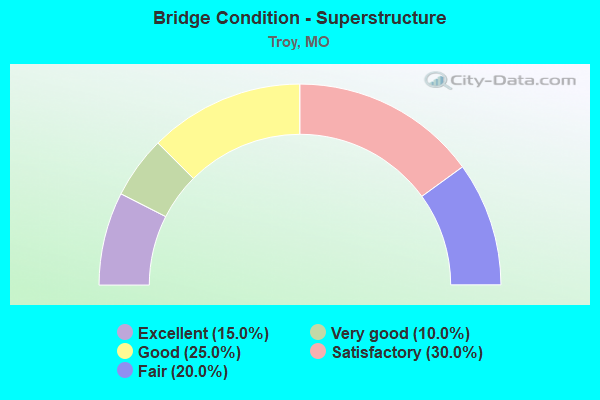
- Bridge Condition - Superstructure
- 15.0%Excellent
- 10.0%Very good
- 25.0%Good
- 30.0%Satisfactory
- 20.0%Fair
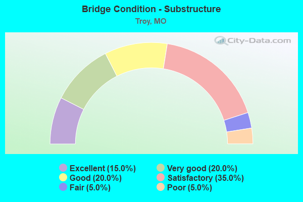
- Bridge Condition - Substructure
- 15.0%Excellent
- 20.0%Very good
- 20.0%Good
- 35.0%Satisfactory
- 5.0%Fair
- 5.0%Poor
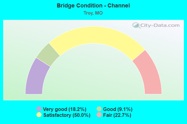
- Bridge Condition - Channel
- 18.2%Very good
- 9.1%Good
- 50.0%Satisfactory
- 22.7%Fair
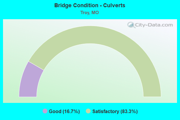
- Bridge Condition - Culverts
- 16.7%Good
- 83.3%Satisfactory
Find on map >> Show street view
Structure Number: 12002, Location: S 30 T 49 N R 1 E (Lat: 38.986092, Lng: -90.948578), Route carried "on" structure: State highway 47, Year Built: 2001, Status: Open, Structure Length: 6.16m (20.21ft), Average Daily Traffic: 12,736 (year 2021), Truck Traffic: 10%, Average Future Daily Traffic: 25,472 (year 2041), Design Load: HS 20, Features Intersected: TOWN BR
Minimum Vertical Clearance: 30+ m (98+ ft), Kilometerpoint: 20.204, Lanes on structure: 2, Base Highway Network: Yes, Owner: State Highway Agency, Approaching Roadway Width: 12.2m (40.0ft), Material/Design: Prestressed concrete continuous, Design/Construction: Stringer/Multi-beam, Number Of Spans In Main Unit: 3, Length of Maximum Span: 20.5m (67.3ft), Curb-To-Curb Width: 11.8m (38.7ft), Out-to-Out Width: 12.6m (41.3ft)
Condition: Deck: Good, Superstructure: Good, Substructure: Excellent, Channel: Very good, Operating Rating: 82.8 metric tons, Method Used To Determine Operating Rating: Load Factor (LF), Inventory Rating: 50.4 metric tons, Method Used To Determine Inventory Rating: Load Factor (LF), Structural Evaluation: Better than present minimum criteria, Deck Geometry: Somewhat better than minimum adequacy, Waterway Adequacy: Superior to present desirable criteria, Approach Roadway Alignment: Equal to present desirable criteria, Designated Inspection Frequency: Every 24 months, Inspection Date: September 2020, Deck Structure Type: Concrete Cast-file-Place, Wearing Surface/Protective System: Wearing Surface: Monolithic Concrete, Deck Protection: Epoxy Coated Reinforcing
Find on map >> Show street view
Structure Number: 12003, Location: S 30 T 49 N R 1 E (Lat: 38.987014, Lng: -90.940981), Route carried "on" structure: State highway 47, Year Built: 2001, Status: Open, Structure Length: 34.29m (112.50ft), Average Daily Traffic: 12,736 (year 2021), Truck Traffic: 10%, Average Future Daily Traffic: 25,472 (year 2041), Design Load: HS 20, Features Intersected: CUIVRE RVR
Minimum Vertical Clearance: 30+ m (98+ ft), Kilometerpoint: 19.396, Lanes on structure: 2, Base Highway Network: Yes, Owner: State Highway Agency, Approaching Roadway Width: 12.2m (40.0ft), Material/Design: Steel continuous, Design/Construction: Stringer/Multi-beam, Number Of Spans In Main Unit: 3, Number Of Approach Spans: 8, Length of Maximum Span: 45.7m (149.9ft), Curb-To-Curb Width: 11.8m (38.7ft), Out-to-Out Width: 12.6m (41.3ft)
Condition: Deck: Good, Superstructure: Good, Substructure: Very good, Channel: Satisfactory, Operating Rating: 75.6 metric tons, Method Used To Determine Operating Rating: Load Factor (LF), Inventory Rating: 34.2 metric tons, Method Used To Determine Inventory Rating: Load Factor (LF), Structural Evaluation: Better than present minimum criteria, Deck Geometry: Somewhat better than minimum adequacy, Waterway Adequacy: Superior to present desirable criteria, Approach Roadway Alignment: Equal to present desirable criteria, Designated Inspection Frequency: Every 24 months, Underwater Inspection Frequency: Every 60 months, Inspection Date: April 2020, Underwater Inspection Date: August 2020, Deck Structure Type: Concrete Cast-file-Place, Wearing Surface/Protective System: Wearing Surface: Monolithic Concrete, Deck Protection: Epoxy Coated Reinforcing
Find on map >> Show street view
Structure Number: 18683, Location: S 29 T 49 N R 1 W (Lat: 38.983256, Lng: -91.035761), Route carried "on" structure: County highway 195, Year Built: 1994, Status: Open, Structure Length: 1.43m (4.69ft), Average Daily Traffic: 75 (year 2021), Truck Traffic: 10%, Average Future Daily Traffic: 120 (year 2041), Features Intersected: UPPER SPRING CR, Facility Carried by Structure: N MOORE SCH RD 560
Minimum Vertical Clearance: 30+ m (98+ ft), Kilometerpoint: 2.575, Lanes on structure: 2, Owner: County Highway Agency, Approaching Roadway Width: 6.1m (20.0ft), Material/Design: Steel, Design/Construction: Stringer/Multi-beam, Number Of Spans In Main Unit: 1, Length of Maximum Span: 13.1m (43.0ft), Curb-To-Curb Width: 7.2m (23.6ft), Out-to-Out Width: 7.3m (24.0ft)
Condition: Deck: Good, Superstructure: Satisfactory, Substructure: Satisfactory, Channel: Fair, Operating Rating: 89.1 metric tons, Method Used To Determine Operating Rating: Load Factor (LF), Inventory Rating: 68.4 metric tons, Method Used To Determine Inventory Rating: Load Factor (LF), Structural Evaluation: Equal to present minimum criteria, Deck Geometry: Somewhat better than minimum adequacy, Waterway Adequacy: Equal to present minimum criteria, Approach Roadway Alignment: Equal to present desirable criteria, Designated Inspection Frequency: Every 24 months, Inspection Date: December 2020, Deck Structure Type: Concrete Cast-file-Place
Find on map >> Show street view
Structure Number: 19566, Location: S 20 T 49 N R 1 E (Lat: 38.998972, Lng: -90.924194), Route carried "on" structure: County highway 225, Year Built: 1979, Year Reconstructed: 1992, Status: Posted for load, Structure Length: 1.31m (4.30ft), Average Daily Traffic: 100 (year 2021), Truck Traffic: 10%, Average Future Daily Traffic: 160 (year 2041), Features Intersected: LIT SUGAR CR, Facility Carried by Structure: THORNHILL CEMRD659
Minimum Vertical Clearance: 30+ m (98+ ft), Kilometerpoint: 1.287, Lanes on structure: 2, Owner: County Highway Agency, Approaching Roadway Width: 6.1m (20.0ft), Material/Design: Steel, Design/Construction: Stringer/Multi-beam, Number Of Spans In Main Unit: 1, Length of Maximum Span: 12.8m (42.0ft), Curb-To-Curb Width: 5.9m (19.4ft), Out-to-Out Width: 6.0m (19.7ft)
Condition: Deck: Fair, Superstructure: Fair, Substructure: Satisfactory, Channel: Satisfactory, Operating Rating: 19.8 metric tons, Method Used To Determine Operating Rating: Allowable Stress (AS), Inventory Rating: 8.1 metric tons, Method Used To Determine Inventory Rating: Allowable Stress (AS), Structural Evaluation: High priority of replacement, Deck Geometry: Meets minimum limits, Waterway Adequacy: Equal to present minimum criteria, Approach Roadway Alignment: Equal to present minimum criteria, Bridge Posting: Required (Relationship of Operating Rating to Maximum Legal Load: 20.0 - 29.9% below), Length Of Structure Improvement: 0.20m (0.66ft), Designated Inspection Frequency: Every 24 months, Inspection Date: December 2020, Bridge Improvement Cost: $146,000, Roadway Improvement Cost: $15,000, Total Project Cost: $220,000 ( Estimate for 2022), Deck Structure Type: Concrete Cast-file-Place
Find on map >> Show street view
Structure Number: 20898, Location: S 34 T 48 N R 1 W (Lat: 38.949419, Lng: -91.012322), Route carried "on" structure: County highway 279, Year Built: 1988, Status: Open, Structure Length: 0.73m (2.40ft), Average Daily Traffic: 150 (year 2021), Truck Traffic: 10%, Average Future Daily Traffic: 240 (year 2041), Features Intersected: MEISTER CR, Facility Carried by Structure: MENNEMEYER RD 753
Minimum Vertical Clearance: 30+ m (98+ ft), Kilometerpoint: 1.127, Lanes on structure: 2, Owner: County Highway Agency, Approaching Roadway Width: 6.1m (20.0ft), Material/Design: Steel, Design/Construction: Stringer/Multi-beam, Number Of Spans In Main Unit: 1, Length of Maximum Span: 6.7m (22.0ft), Curb-To-Curb Width: 7.3m (24.0ft), Out-to-Out Width: 7.3m (24.0ft)
Condition: Deck: Good, Superstructure: Satisfactory, Substructure: Fair, Channel: Fair, Operating Rating: 36.9 metric tons, Method Used To Determine Operating Rating: Allowable Stress (AS), Inventory Rating: 18.0 metric tons, Method Used To Determine Inventory Rating: Allowable Stress (AS), Structural Evaluation: Somewhat better than minimum adequacy, Deck Geometry: Somewhat better than minimum adequacy, Waterway Adequacy: Equal to present minimum criteria, Approach Roadway Alignment: Equal to present desirable criteria, Designated Inspection Frequency: Every 24 months, Inspection Date: December 2020, Deck Structure Type: Concrete Cast-file-Place
Find on map >> Show street view
Structure Number: 20907, Location: S 10 T 48 N R 1 W (Lat: 38.943306, Lng: -91.012528), Route carried "on" structure: County highway 279, Year Built: 1989, Status: Open, Structure Length: 1.62m (5.31ft), Average Daily Traffic: 150 (year 2021), Truck Traffic: 10%, Average Future Daily Traffic: 240 (year 2041), Features Intersected: CROOKED CR, Facility Carried by Structure: MENNEMEYER RD 753
Minimum Vertical Clearance: 30+ m (98+ ft), Kilometerpoint: 1.931, Lanes on structure: 2, Owner: County Highway Agency, Approaching Roadway Width: 6.1m (20.0ft), Material/Design: Steel, Design/Construction: Stringer/Multi-beam, Number Of Spans In Main Unit: 1, Length of Maximum Span: 15.2m (49.9ft), Curb-To-Curb Width: 7.1m (23.3ft), Out-to-Out Width: 7.3m (24.0ft)
Condition: Deck: Poor, Superstructure: Fair, Substructure: Satisfactory, Channel: Satisfactory, Operating Rating: 61.2 metric tons, Method Used To Determine Operating Rating: Allowable Stress (AS), Inventory Rating: 36.9 metric tons, Method Used To Determine Inventory Rating: Allowable Stress (AS), Structural Evaluation: Somewhat better than minimum adequacy, Deck Geometry: Meets minimum limits, Waterway Adequacy: Equal to present minimum criteria, Approach Roadway Alignment: Equal to present desirable criteria, Length Of Structure Improvement: 0.23m (0.75ft), Designated Inspection Frequency: Every 24 months, Inspection Date: December 2020, Bridge Improvement Cost: $113,000, Roadway Improvement Cost: $11,000, Total Project Cost: $170,000 ( Estimate for 2022), Deck Structure Type: Concrete Cast-file-Place
Find on map >> Show street view
Structure Number: 21146, Location: S 24 T 48 N R 1 W (Lat: 38.907861, Lng: -90.967472), Route carried "on" structure: County highway 291, Year Built: 1995, Status: Open, Structure Length: 1.01m (3.31ft), Average Daily Traffic: 100 (year 2021), Truck Traffic: 10%, Average Future Daily Traffic: 160 (year 2041), Features Intersected: SAND RUN CR, Facility Carried by Structure: SPIELHAGEN RD725
Minimum Vertical Clearance: 30+ m (98+ ft), Kilometerpoint: 2.897, Lanes on structure: 2, Owner: County Highway Agency, Approaching Roadway Width: 6.7m (22.0ft), Skew: 2 degrees, Material/Design: Steel, Design/Construction: Stringer/Multi-beam, Number Of Spans In Main Unit: 1, Length of Maximum Span: 8.8m (28.9ft), Curb or Sidewalk Widths: Left: 0.1m (0.3ft), Right: 0.1m (0.3ft), Curb-To-Curb Width: 7.2m (23.6ft), Out-to-Out Width: 7.3m (24.0ft)
Condition: Deck: Good, Superstructure: Satisfactory, Substructure: Satisfactory, Channel: Satisfactory, Operating Rating: 89.1 metric tons, Method Used To Determine Operating Rating: Allowable Stress (AS), Inventory Rating: 53.1 metric tons, Method Used To Determine Inventory Rating: Allowable Stress (AS), Structural Evaluation: Equal to present minimum criteria, Deck Geometry: Somewhat better than minimum adequacy, Waterway Adequacy: Equal to present minimum criteria, Approach Roadway Alignment: Equal to present desirable criteria, Designated Inspection Frequency: Every 24 months, Inspection Date: December 2020, Deck Structure Type: Concrete Cast-file-Place
Find on map >> Show street view
Structure Number: 21156, Location: S 24 T 48 N R 1 W (Lat: 38.907722, Lng: -90.966167), Route carried "on" structure: County highway 292, Year Built: 1998, Status: Open, Structure Length: 1.52m (4.99ft), Average Daily Traffic: 250 (year 2021), Truck Traffic: 20%, Average Future Daily Traffic: 400 (year 2041), Features Intersected: SAND RUN CR, Facility Carried by Structure: MEYER RD 729
Minimum Vertical Clearance: 30+ m (98+ ft), Kilometerpoint: 1.127, Lanes on structure: 2, Owner: County Highway Agency, Approaching Roadway Width: 6.7m (22.0ft), Material/Design: Steel, Design/Construction: Stringer/Multi-beam, Number Of Spans In Main Unit: 1, Length of Maximum Span: 14.0m (45.9ft), Curb or Sidewalk Widths: Left: 0.1m (0.3ft), Right: 0.1m (0.3ft), Curb-To-Curb Width: 7.2m (23.6ft), Out-to-Out Width: 7.3m (24.0ft)
Condition: Deck: Very good, Superstructure: Good, Substructure: Good, Channel: Satisfactory, Operating Rating: 70.2 metric tons, Method Used To Determine Operating Rating: Load Factor (LF), Inventory Rating: 42.3 metric tons, Method Used To Determine Inventory Rating: Load Factor (LF), Structural Evaluation: Better than present minimum criteria, Deck Geometry: Meets minimum limits, Waterway Adequacy: Better than present minimum criteria, Approach Roadway Alignment: Equal to present desirable criteria, Designated Inspection Frequency: Every 24 months, Inspection Date: December 2020, Deck Structure Type: Concrete Cast-file-Place, Wearing Surface/Protective System: Wearing Surface: Bituminous
Find on map >> Show street view
Structure Number: 21194, Location: S 11 T 48 N R 1 W (Lat: 38.936778, Lng: -90.983194), Route carried "on" structure: County highway 294, Year Built: 1992, Status: Open, Structure Length: 1.77m (5.81ft), Average Daily Traffic: 50 (year 2021), Truck Traffic: 10%, Average Future Daily Traffic: 80 (year 2041), Features Intersected: CROOKED CR, Facility Carried by Structure: SUGAR GROVE RD 709
Minimum Vertical Clearance: 30+ m (98+ ft), Kilometerpoint: 1.770, Lanes on structure: 2, Owner: County Highway Agency, Approaching Roadway Width: 5.5m (18.0ft), Material/Design: Steel, Design/Construction: Stringer/Multi-beam, Number Of Spans In Main Unit: 1, Length of Maximum Span: 16.8m (55.1ft), Curb-To-Curb Width: 7.2m (23.6ft), Out-to-Out Width: 7.3m (24.0ft)
Condition: Deck: Satisfactory, Superstructure: Satisfactory, Substructure: Satisfactory, Channel: Fair, Operating Rating: 36.0 metric tons, Method Used To Determine Operating Rating: Allowable Stress (AS), Inventory Rating: 22.5 metric tons, Method Used To Determine Inventory Rating: Allowable Stress (AS), Structural Evaluation: Equal to present minimum criteria, Deck Geometry: Somewhat better than minimum adequacy, Waterway Adequacy: Equal to present minimum criteria, Approach Roadway Alignment: Equal to present desirable criteria, Designated Inspection Frequency: Every 24 months, Inspection Date: December 2020, Deck Structure Type: Concrete Cast-file-Place
Find on map >> Show street view
Structure Number: 2252, Location: S 25 T 49 N R 1 W (Lat: 38.989422, Lng: -90.965589), Route carried "on" structure: US 61, Year Built: 1970, Status: Open, Structure Length: 1.08m (3.54ft), Average Daily Traffic: 20,395 (year 2021), Truck Traffic: 26%, Average Future Daily Traffic: 40,790 (year 2041), Design Load: HS 20, Features Intersected: TOWN BR
Minimum Vertical Clearance: 30+ m (98+ ft), Kilometerpoint: 195.186, Lanes on structure: 4, Base Highway Network: Yes, Owner: State Highway Agency, Approaching Roadway Width: 13.4m (44.0ft), Skew: 24 degrees, Material/Design: Concrete continuous, Design/Construction: Culvert, Number Of Spans In Main Unit: 2, Length of Maximum Span: 3.7m (12.1ft)
Condition: Channel: Satisfactory, Culverts: Satisfactory, Inventory Rating: 61.2 metric tons, Method Used To Determine Inventory Rating: Load Factor (LF), Structural Evaluation: Equal to present minimum criteria, Waterway Adequacy: Equal to present desirable criteria, Approach Roadway Alignment: Equal to present desirable criteria, Designated Inspection Frequency: Every 24 months, Inspection Date: September 2020
Find on map >> Show street view
Structure Number: 2253, Location: S 25 T 49 N R 1 W (Lat: 38.986553, Lng: -90.965511), Route carried "on" structure: State highway 47, Year Built: 1969, Status: Open, Structure Length: 7.56m (24.80ft), Average Daily Traffic: 16,379 (year 2021), Truck Traffic: 9%, Average Future Daily Traffic: 32,758 (year 2041), Design Load: H 20, Features Intersected: US 61
Minimum Vertical Clearance: 30+ m (98+ ft), Kilometerpoint: 21.671, Lanes on structure: 2, Lanes under structure: 4, Owner: State Highway Agency, Approaching Roadway Width: 13.4m (44.0ft), Material/Design: Steel continuous, Design/Construction: Stringer/Multi-beam, Number Of Spans In Main Unit: 2, Number Of Approach Spans: 2, Length of Maximum Span: 26.5m (86.9ft), Curb-To-Curb Width: 13.4m (44.0ft), Out-to-Out Width: 14.2m (46.6ft)
Condition: Deck: Satisfactory, Superstructure: Satisfactory, Substructure: Satisfactory, Operating Rating: 39.6 metric tons, Method Used To Determine Operating Rating: Load Factor (LF), Inventory Rating: 23.4 metric tons, Method Used To Determine Inventory Rating: Load Factor (LF), Structural Evaluation: Somewhat better than minimum adequacy, Deck Geometry: Equal to present minimum criteria, Underclear: Somewhat better than minimum adequacy, Approach Roadway Alignment: Equal to present desirable criteria, Designated Inspection Frequency: Every 24 months, Inspection Date: September 2020, Deck Structure Type: Concrete Cast-file-Place, Wearing Surface/Protective System: Wearing Surface: Epoxy Overlay
Find on map >> Show street view
Structure Number: 2254, Location: S 25 T 49 N R 1 W (Lat: 38.983900, Lng: -90.965492), Route carried "on" structure: City street , Year Built: 1970, Status: Open, Structure Length: 8.41m (27.59ft), Average Daily Traffic: 5,452 (year 2021), Truck Traffic: 4%, Average Future Daily Traffic: 10,904 (year 2041), Design Load: H 20, Features Intersected: US 61, Facility Carried by Structure: EAST CHERRY ST E
Minimum Vertical Clearance: 30+ m (98+ ft), Kilometerpoint: 1.418, Lanes on structure: 2, Lanes under structure: 4, Owner: State Highway Agency, Approaching Roadway Width: 7.3m (24.0ft), Skew: 1 degrees, Material/Design: Steel continuous, Design/Construction: Stringer/Multi-beam, Number Of Spans In Main Unit: 3, Number Of Approach Spans: 1, Length of Maximum Span: 29.0m (95.1ft), Curb-To-Curb Width: 10.4m (34.1ft), Out-to-Out Width: 11.2m (36.7ft)
Condition: Deck: Satisfactory, Superstructure: Satisfactory, Substructure: Satisfactory, Operating Rating: 40.5 metric tons, Method Used To Determine Operating Rating: Allowable Stress (AS), Inventory Rating: 23.4 metric tons, Method Used To Determine Inventory Rating: Allowable Stress (AS), Structural Evaluation: Somewhat better than minimum adequacy, Deck Geometry: Meets minimum limits, Underclear: Somewhat better than minimum adequacy, Approach Roadway Alignment: Equal to present desirable criteria, Designated Inspection Frequency: Every 24 months, Other Special Inspection Frequency: Every 24 months, Inspection Date: April 2020, Other Special Inspection Date: April 2020, Deck Structure Type: Concrete Cast-file-Place, Wearing Surface/Protective System: Wearing Surface: Epoxy Overlay
Find on map >> Show street view
Structure Number: 2255, Location: S 25 T 49 N R 1 W (Lat: 38.977233, Lng: -90.963211), Route carried "on" structure: City street , Year Built: 1970, Status: Open, Structure Length: 8.14m (26.71ft), Average Daily Traffic: 3,177 (year 2021), Truck Traffic: 7%, Average Future Daily Traffic: 6,354 (year 2041), Design Load: H 15, Features Intersected: US 61, Facility Carried by Structure: OLD CAP AU GRIS RD
Minimum Vertical Clearance: 30+ m (98+ ft), Kilometerpoint: 0.396, Lanes on structure: 2, Lanes under structure: 4, Owner: State Highway Agency, Approaching Roadway Width: 6.1m (20.0ft), Skew: 2 degrees, Material/Design: Steel continuous, Design/Construction: Stringer/Multi-beam, Number Of Spans In Main Unit: 2, Number Of Approach Spans: 2, Length of Maximum Span: 27.7m (90.9ft), Curb-To-Curb Width: 8.5m (27.9ft), Out-to-Out Width: 9.4m (30.8ft)
Condition: Deck: Satisfactory, Superstructure: Fair, Substructure: Good, Operating Rating: 30.6 metric tons, Method Used To Determine Operating Rating: Load Factor (LF), Inventory Rating: 18.0 metric tons, Method Used To Determine Inventory Rating: Load Factor (LF), Structural Evaluation: Somewhat better than minimum adequacy, Deck Geometry: Meets minimum limits, Underclear: Somewhat better than minimum adequacy, Approach Roadway Alignment: Better than present minimum criteria, Designated Inspection Frequency: Every 24 months, Other Special Inspection Frequency: Every 24 months, Inspection Date: April 2020, Other Special Inspection Date: April 2020, Deck Structure Type: Concrete Cast-file-Place, Wearing Surface/Protective System: Wearing Surface: Monolithic Concrete
Find on map >> Show street view
Structure Number: 2372, Location: S 4 T 49 N R 1 W (Lat: 38.972667, Lng: -90.965972), Route carried "on" structure: City street , Year Built: 1950, Status: Open, Structure Length: 0.79m (2.59ft), Average Daily Traffic: 2,000 (year 2021), Truck Traffic: 10%, Average Future Daily Traffic: 3,200 (year 2041), Design Load: H 10, Features Intersected: BUCHANAN CR, Facility Carried by Structure: S LINCOLN DR
Minimum Vertical Clearance: 30+ m (98+ ft), Kilometerpoint: 0.161, Lanes on structure: 2, Owner: County Highway Agency, Maintenance Responsibility: City or Municipal Highway Agency, Approaching Roadway Width: 13.1m (43.0ft), Material/Design: Concrete, Design/Construction: Culvert, Number Of Spans In Main Unit: 2, Length of Maximum Span: 3.4m (11.2ft), Curb-To-Curb Width: 12.5m (41.0ft), Out-to-Out Width: 13.1m (43.0ft)
Condition: Channel: Satisfactory, Culverts: Satisfactory, Operating Rating: 49.5 metric tons, Method Used To Determine Operating Rating: Allowable Stress (AS), Inventory Rating: 22.5 metric tons, Method Used To Determine Inventory Rating: Allowable Stress (AS), Structural Evaluation: Equal to present minimum criteria, Deck Geometry: Better than present minimum criteria, Waterway Adequacy: Equal to present minimum criteria, Approach Roadway Alignment: Equal to present desirable criteria, Designated Inspection Frequency: Every 24 months, Inspection Date: December 2020
Find on map >> Show street view
Structure Number: 28233, Location: S 35 T 49 N R 1 W (Lat: 38.961222, Lng: -90.974000), Route carried "on" structure: City street , Year Built: 1998, Status: Open, Structure Length: 0.91m (2.99ft), Average Daily Traffic: 1,000 (year 2021), Truck Traffic: 10%, Average Future Daily Traffic: 1,600 (year 2041), Features Intersected: WITCOMB BR, Facility Carried by Structure: SAND RUN RD
Minimum Vertical Clearance: 30+ m (98+ ft), Kilometerpoint: 0.483, Lanes on structure: 2, Owner: City or Municipal Highway Agency, Approaching Roadway Width: 9.1m (29.9ft), Skew: 2 degrees, Material/Design: Concrete, Design/Construction: Culvert, Number Of Spans In Main Unit: 2, Length of Maximum Span: 3.7m (12.1ft)
Condition: Channel: Fair, Culverts: Good, Operating Rating: 87.3 metric tons, Method Used To Determine Operating Rating: Field evaluation and documented engineering judgment, Inventory Rating: 52.2 metric tons, Method Used To Determine Inventory Rating: Field evaluation and documented engineering judgment, Structural Evaluation: Better than present minimum criteria, Waterway Adequacy: Better than present minimum criteria, Approach Roadway Alignment: Equal to present desirable criteria, Designated Inspection Frequency: Every 24 months, Inspection Date: December 2020
Find on map >> Show street view
Structure Number: 32153, Location: S 18 T 49 N R 1 E (Lat: 39.005086, Lng: -90.946289), Route carried "on" structure: County highway 216, Year Built: 2008, Status: Open, Structure Length: 8.41m (27.59ft), Average Daily Traffic: 150 (year 2021), Truck Traffic: 10%, Average Future Daily Traffic: 240 (year 2041), Design Load: HS 20, Features Intersected: CUIVRE RVR, Facility Carried by Structure: FRENCHMAN'S BLUFF
Minimum Vertical Clearance: 30+ m (98+ ft), Kilometerpoint: 0.966, Lanes on structure: 2, Owner: County Highway Agency, Approaching Roadway Width: 6.1m (20.0ft), Skew: 4 degrees, Material/Design: Prestressed concrete continuous, Design/Construction: Stringer/Multi-beam, Number Of Spans In Main Unit: 3, Length of Maximum Span: 28.0m (91.9ft), Curb-To-Curb Width: 7.3m (24.0ft), Out-to-Out Width: 7.5m (24.6ft)
Condition: Deck: Good, Superstructure: Very good, Substructure: Very good, Channel: Good, Operating Rating: 55.8 metric tons, Method Used To Determine Operating Rating: Load Factor (LF), Inventory Rating: 33.3 metric tons, Method Used To Determine Inventory Rating: Load Factor (LF), Structural Evaluation: Equal to present desirable criteria, Deck Geometry: Somewhat better than minimum adequacy, Waterway Adequacy: Somewhat better than minimum adequacy, Approach Roadway Alignment: Somewhat better than minimum adequacy, Designated Inspection Frequency: Every 24 months, Inspection Date: December 2020, Deck Structure Type: Concrete Cast-file-Place, Wearing Surface/Protective System: Wearing Surface: Monolithic Concrete
Find on map >> Show street view
Structure Number: 32216, Location: S 21 T 49 N R 1 W (Lat: 38.997111, Lng: -91.016444), Route carried "on" structure: County highway 196, Year Built: 2007, Status: Open, Structure Length: 0.74m (2.43ft), Average Daily Traffic: 50 (year 2021), Truck Traffic: 10%, Average Future Daily Traffic: 80 (year 2041), Features Intersected: SPRING BR, Facility Carried by Structure: HILL CR RD 564
Minimum Vertical Clearance: 30+ m (98+ ft), Kilometerpoint: 3.541, Lanes on structure: 2, Owner: County Highway Agency, Approaching Roadway Width: 5.5m (18.0ft), Skew: 1 degrees, Material/Design: Concrete, Design/Construction: Culvert, Number Of Spans In Main Unit: 3, Length of Maximum Span: 2.2m (7.2ft), Curb-To-Curb Width: 6.6m (21.7ft), Out-to-Out Width: 7.6m (24.9ft)
Condition: Channel: Good, Culverts: Satisfactory, Operating Rating: 83.7 metric tons, Method Used To Determine Operating Rating: Load Factor (LF), Inventory Rating: 40.5 metric tons, Method Used To Determine Inventory Rating: Load Factor (LF), Structural Evaluation: Equal to present minimum criteria, Deck Geometry: Somewhat better than minimum adequacy, Waterway Adequacy: Somewhat better than minimum adequacy, Approach Roadway Alignment: Equal to present minimum criteria, Designated Inspection Frequency: Every 24 months, Inspection Date: December 2020
Find on map >> Show street view
Structure Number: 33791, Location: S 17 T 49 N R 1 E (Lat: 39.004636, Lng: -90.928786), Route carried "on" structure: State highway 147, Year Built: 2011, Status: Open, Structure Length: 4.57m (14.99ft), Average Daily Traffic: 1,738 (year 2021), Truck Traffic: 3%, Average Future Daily Traffic: 3,476 (year 2041), Design Load: HS 20, Features Intersected: BIG SUGAR CR
Minimum Vertical Clearance: 30+ m (98+ ft), Kilometerpoint: 0.013, Lanes on structure: 2, Owner: State Highway Agency, Approaching Roadway Width: 7.3m (24.0ft), Skew: 1 degrees, Material/Design: Prestressed concrete, Design/Construction: Box Beam or Girders - Single/Spread, Number Of Spans In Main Unit: 3, Length of Maximum Span: 18.3m (60.0ft), Curb-To-Curb Width: 7.3m (24.0ft), Out-to-Out Width: 7.9m (25.9ft)
Condition: Deck: Good, Superstructure: Excellent, Substructure: Good, Channel: Satisfactory, Operating Rating: 73.8 metric tons, Method Used To Determine Operating Rating: Load Factor (LF), Inventory Rating: 41.4 metric tons, Method Used To Determine Inventory Rating: Load Factor (LF), Structural Evaluation: Better than present minimum criteria, Deck Geometry: Meets minimum limits, Waterway Adequacy: Superior to present desirable criteria, Approach Roadway Alignment: Equal to present desirable criteria, Designated Inspection Frequency: Every 48 months, Inspection Date: September 2020, Deck Structure Type: Concrete Cast-file-Place, Wearing Surface/Protective System: Wearing Surface: Monolithic Concrete, Deck Protection: Epoxy Coated Reinforcing
Find on map >> Show street view
Structure Number: 34163, Location: S 36 T 49 N R 1 W (Lat: 38.967025, Lng: -90.956894), Route carried "on" structure: City street , Year Built: 2012, Status: Open, Structure Length: 8.19m (26.87ft), Average Daily Traffic: 7,559 (year 2021), Truck Traffic: 5%, Average Future Daily Traffic: 15,118 (year 2041), Features Intersected: US 61, Facility Carried by Structure: SOUTH LINCOLN DR S
Minimum Vertical Clearance: 5.07m (16.63ft), Kilometerpoint: 2.456, Lanes on structure: 2, Lanes under structure: 4, Owner: State Highway Agency, Approaching Roadway Width: 9.8m (32.2ft), Skew: 1 degrees, Material/Design: Prestressed concrete, Design/Construction: Tee Beam, Number Of Spans In Main Unit: 2, Length of Maximum Span: 41.1m (134.8ft), Curb-To-Curb Width: 9.8m (32.2ft), Out-to-Out Width: 10.6m (34.8ft)
Condition: Deck: Very good, Superstructure: Very good, Substructure: Very good, Operating Rating: 56.7 metric tons, Method Used To Determine Operating Rating: Load Factor (LF), Inventory Rating: 34.2 metric tons, Method Used To Determine Inventory Rating: Load Factor (LF), Structural Evaluation: Equal to present desirable criteria, Deck Geometry: Meets minimum limits, Underclear: Equal to present minimum criteria, Approach Roadway Alignment: Equal to present desirable criteria, Designated Inspection Frequency: Every 24 months, Inspection Date: September 2020, Deck Structure Type: Concrete Cast-file-Place, Wearing Surface/Protective System: Wearing Surface: Monolithic Concrete, Deck Protection: Epoxy Coated Reinforcing
Find on map >> Show street view
Structure Number: 3486, Location: S 12 T 48 N R 1 W (Lat: 38.943639, Lng: -90.968306), Route carried "on" structure: County highway 295, Year Built: 2014, Status: Open, Structure Length: 1.98m (6.50ft), Average Daily Traffic: 500 (year 2021), Truck Traffic: 10%, Average Future Daily Traffic: 800 (year 2041), Features Intersected: CROOKED CR, Facility Carried by Structure: SAND RUN RD 711
Minimum Vertical Clearance: 30+ m (98+ ft), Kilometerpoint: 1.127, Lanes on structure: 2, Owner: County Highway Agency, Approaching Roadway Width: 6.1m (20.0ft), Skew: 3 degrees, Material/Design: Prestressed concrete, Design/Construction: Box Beam or Girders - Multiple, Number Of Spans In Main Unit: 1, Length of Maximum Span: 19.0m (62.3ft), Curb-To-Curb Width: 7.3m (24.0ft), Out-to-Out Width: 7.3m (24.0ft)
Condition: Deck: Good, Superstructure: Good, Substructure: Excellent, Channel: Very good, Operating Rating: 62.1 metric tons, Method Used To Determine Operating Rating: Load Factor (LF), Inventory Rating: 36.9 metric tons, Method Used To Determine Inventory Rating: Load Factor (LF), Structural Evaluation: Better than present minimum criteria, Deck Geometry: Meets minimum limits, Waterway Adequacy: Superior to present desirable criteria, Approach Roadway Alignment: Equal to present desirable criteria, Designated Inspection Frequency: Every 24 months, Inspection Date: December 2020, Deck Structure Type: Concrete Cast-file-Place, Wearing Surface/Protective System: Wearing Surface: Bituminous
Find on map >> Show street view
Structure Number: 35836, Location: S 21 T 49 N R 1 W (Lat: 38.990278, Lng: -91.020833), Route carried "on" structure: County highway 197, Year Built: 2018, Status: Open, Structure Length: 1.95m (6.40ft), Average Daily Traffic: 150 (year 2021), Truck Traffic: 10%, Average Future Daily Traffic: 240 (year 2041), Features Intersected: SPRING CR BR, Facility Carried by Structure: SNYDER RD
Minimum Vertical Clearance: 30+ m (98+ ft), Kilometerpoint: 2.414, Lanes on structure: 2, Owner: County Highway Agency, Approaching Roadway Width: 7.3m (24.0ft), Material/Design: Concrete, Design/Construction: Box Beam or Girders - Multiple, Number Of Spans In Main Unit: 1, Length of Maximum Span: 18.7m (61.4ft), Curb-To-Curb Width: 7.2m (23.6ft), Out-to-Out Width: 7.3m (24.0ft)
Condition: Deck: Excellent, Superstructure: Excellent, Substructure: Excellent, Channel: Very good, Operating Rating: 58.5 metric tons, Method Used To Determine Operating Rating: Load Factor (LF), Inventory Rating: 41.4 metric tons, Method Used To Determine Inventory Rating: Load Factor (LF), Structural Evaluation: Superior to present desirable criteria, Deck Geometry: Meets minimum limits, Waterway Adequacy: Superior to present desirable criteria, Approach Roadway Alignment: Equal to present desirable criteria, Designated Inspection Frequency: Every 24 months, Inspection Date: December 2020, Deck Structure Type: Concrete Cast-file-Place, Wearing Surface/Protective System: Wearing Surface: Monolithic Concrete, Deck Protection: Epoxy Coated Reinforcing
Find on map >> Show street view
Structure Number: 36002, Location: S 14 T 49 N R 1 W (Lat: 39.009953, Lng: -90.978175), Route carried "on" structure: US 61, Year Built: 2019, Status: Open, Structure Length: 30.72m (100.79ft), Average Daily Traffic: 11,034 (year 2021), Truck Traffic: 25%, Average Future Daily Traffic: 22,068 (year 2041), Features Intersected: CUIVRE RVR
Minimum Vertical Clearance: 30+ m (98+ ft), Kilometerpoint: 192.471, Lanes on structure: 2, Base Highway Network: Yes, Owner: State Highway Agency, Approaching Roadway Width: 11.6m (38.1ft), Material/Design: Prestressed concrete continuous, Design/Construction: Tee Beam, Number Of Spans In Main Unit: 8, Length of Maximum Span: 39.0m (128.0ft), Curb-To-Curb Width: 11.6m (38.1ft), Out-to-Out Width: 12.4m (40.7ft)
Condition: Deck: Excellent, Superstructure: Excellent, Substructure: Very good, Channel: Very good, Operating Rating: 63.9 metric tons, Method Used To Determine Operating Rating: Load Factor (LF), Inventory Rating: 40.5 metric tons, Method Used To Determine Inventory Rating: Load Factor (LF), Structural Evaluation: Equal to present desirable criteria, Deck Geometry: Better than present minimum criteria, Waterway Adequacy: Superior to present desirable criteria, Approach Roadway Alignment: Equal to present desirable criteria, Designated Inspection Frequency: Every 24 months, Inspection Date: January 2021, Deck Structure Type: Concrete Cast-file-Place, Wearing Surface/Protective System: Wearing Surface: Monolithic Concrete, Deck Protection: Epoxy Coated Reinforcing
Find on map >> Show street view
Structure Number: 4928, Location: S 31 T 49 N R 1 E (Lat: 38.962567, Lng: -90.951119), Route carried "on" structure: US 61, Year Built: 1961, Year Reconstructed: 1970, Status: Open, Structure Length: 0.76m (2.49ft), Average Daily Traffic: 32,214 (year 2021), Truck Traffic: 17%, Average Future Daily Traffic: 64,428 (year 2041), Design Load: HS 20, Features Intersected: WHITCOMB CR
Minimum Vertical Clearance: 30+ m (98+ ft), Kilometerpoint: 198.490, Lanes on structure: 4, Base Highway Network: Yes, Owner: State Highway Agency, Approaching Roadway Width: 13.4m (44.0ft), Skew: 20 degrees, Material/Design: Concrete continuous, Design/Construction: Culvert, Number Of Spans In Main Unit: 2, Length of Maximum Span: 3.7m (12.1ft)
Condition: Channel: Satisfactory, Culverts: Satisfactory, Operating Rating: 98.1 metric tons, Method Used To Determine Operating Rating: Load Factor (LF), Inventory Rating: 59.4 metric tons, Method Used To Determine Inventory Rating: Load Factor (LF), Structural Evaluation: Equal to present minimum criteria, Waterway Adequacy: Equal to present desirable criteria, Approach Roadway Alignment: Equal to present desirable criteria, Designated Inspection Frequency: Every 24 months, Inspection Date: September 2020
Find on map >> Show street view
Structure Number: 6548, Location: S 21 T 49 N R 1 E (Lat: 39.008019, Lng: -90.921003), Route carried "on" structure: State highway 147, Year Built: 1941, Status: Open, Structure Length: 2.47m (8.10ft), Average Daily Traffic: 1,738 (year 2021), Truck Traffic: 3%, Average Future Daily Traffic: 3,476 (year 2041), Design Load: H 10, Features Intersected: LIT SUGAR CR
Minimum Vertical Clearance: 30+ m (98+ ft), Kilometerpoint: 0.861, Lanes on structure: 2, Owner: State Highway Agency, Approaching Roadway Width: 6.1m (20.0ft), Skew: 1 degrees, Material/Design: Concrete, Design/Construction: Arch - Deck, Number Of Spans In Main Unit: 3, Length of Maximum Span: 5.5m (18.0ft), Curb-To-Curb Width: 5.5m (18.0ft), Out-to-Out Width: 6.1m (20.0ft)
Condition: Deck: Satisfactory, Superstructure: Fair, Substructure: Poor, Channel: Fair, Operating Rating: 55.8 metric tons, Method Used To Determine Operating Rating: Allowable Stress (AS), Inventory Rating: 39.6 metric tons, Method Used To Determine Inventory Rating: Allowable Stress (AS), Structural Evaluation: Meets minimum limits, Deck Geometry: High priority of replacement, Waterway Adequacy: Equal to present desirable criteria, Approach Roadway Alignment: Equal to present minimum criteria, Length Of Structure Improvement: 0.33m (1.08ft), Designated Inspection Frequency: Every 24 months, Inspection Date: September 2021, Bridge Improvement Cost: $415,000, Roadway Improvement Cost: $41,000, Total Project Cost: $622,000 ( Estimate for 2022), Wearing Surface/Protective System: Wearing Surface: Bituminous, Membrane: Built-up
Find on map >> Show street view
Structure Number: 8425, Location: S 10 T 48 N R 1 W (Lat: 38.941553, Lng: -90.995847), Route carried "on" structure: State highway J, Year Built: 1966, Status: Open, Structure Length: 1.02m (3.35ft), Average Daily Traffic: 3,171 (year 2021), Truck Traffic: 4%, Average Future Daily Traffic: 6,342 (year 2041), Design Load: H 15, Features Intersected: CROOKED CR
Minimum Vertical Clearance: 30+ m (98+ ft), Kilometerpoint: 4.752, Lanes on structure: 2, Owner: State Highway Agency, Approaching Roadway Width: 7.3m (24.0ft), Skew: 2 degrees, Material/Design: Concrete continuous, Design/Construction: Culvert, Number Of Spans In Main Unit: 3, Length of Maximum Span: 3.0m (9.8ft), Curb-To-Curb Width: 10.1m (33.1ft), Out-to-Out Width: 10.8m (35.4ft)
Condition: Channel: Satisfactory, Culverts: Satisfactory, Operating Rating: 52.2 metric tons, Method Used To Determine Operating Rating: Load Factor (LF), Inventory Rating: 31.5 metric tons, Method Used To Determine Inventory Rating: Load Factor (LF), Structural Evaluation: Equal to present minimum criteria, Deck Geometry: Meets minimum limits, Waterway Adequacy: Equal to present minimum criteria, Approach Roadway Alignment: Equal to present minimum criteria, Designated Inspection Frequency: Every 24 months, Inspection Date: September 2020
Find on map >> Show street view
Structure Number: 8426, Location: S 22 T 48 N R 1 W (Lat: 38.915225, Lng: -91.011142), Route carried "on" structure: State highway J, Year Built: 1966, Year Reconstructed: 2015, Status: Open, Structure Length: 4.91m (16.11ft), Average Daily Traffic: 1,902 (year 2021), Truck Traffic: 4%, Average Future Daily Traffic: 3,804 (year 2041), Design Load: H 15, Features Intersected: COON CR
Minimum Vertical Clearance: 30+ m (98+ ft), Kilometerpoint: 8.058, Lanes on structure: 2, Owner: State Highway Agency, Approaching Roadway Width: 6.1m (20.0ft), Material/Design: Steel continuous, Design/Construction: Stringer/Multi-beam, Number Of Spans In Main Unit: 3, Length of Maximum Span: 18.9m (62.0ft), Curb-To-Curb Width: 7.3m (24.0ft), Out-to-Out Width: 8.4m (27.6ft)
Condition: Deck: Very good, Superstructure: Good, Substructure: Good, Channel: Satisfactory, Operating Rating: 26.1 metric tons, Method Used To Determine Operating Rating: Load Factor (LF), Inventory Rating: 15.3 metric tons, Method Used To Determine Inventory Rating: Load Factor (LF), Structural Evaluation: Meets minimum limits, Deck Geometry: Meets minimum limits, Waterway Adequacy: Equal to present desirable criteria, Approach Roadway Alignment: Better than present minimum criteria, Designated Inspection Frequency: Every 24 months, Inspection Date: September 2020, Deck Structure Type: Concrete Cast-file-Place, Wearing Surface/Protective System: Wearing Surface: Monolithic Concrete, Deck Protection: Epoxy Coated Reinforcing
Find on map >> Show street view
Structure Number: 2253, Location: S 25 T 49 N R 1 W (Lat: 38.986553, Lng: -90.965511), Route carried "under" structure: US 61, Year Built: 1969, Structure Length: 0. m, Average Daily Traffic: 9,859 (year 2021), Truck Traffic: 26%, Features Intersected: US 61, Facility Carried by Structure: MO 47 S
Minimum Vertical Clearance: 4.98m (16.34ft), Kilometerpoint: 195.510, Lanes on structure: 2, Lanes under structure: 2, Material/Design: Steel continuous, Design/Construction: Stringer/Multi-beam, Length of Maximum Span: 26.5m (86.9ft)
Find on map >> Show street view
Structure Number: 2253, Location: S 25 T 49 N R 1 W (Lat: 38.986553, Lng: -90.965511), Route carried "under" structure: US 61, Year Built: 1969, Structure Length: 0. m, Average Daily Traffic: 13,684 (year 2021), Truck Traffic: 20%, Features Intersected: US 61, Facility Carried by Structure: MO 47 S
Minimum Vertical Clearance: 5.11m (16.77ft), Kilometerpoint: 438.644, Lanes on structure: 2, Lanes under structure: 2, Material/Design: Steel continuous, Design/Construction: Stringer/Multi-beam, Length of Maximum Span: 26.5m (86.9ft)
Find on map >> Show street view
Structure Number: 2254, Location: S 25 T 49 N R 1 W (Lat: 38.983900, Lng: -90.965492), Route carried "under" structure: US 61, Year Built: 1970, Structure Length: 0. m, Average Daily Traffic: 15,046 (year 2021), Truck Traffic: 21%, Features Intersected: US 61, Facility Carried by Structure: EAST CHERRY ST E
Minimum Vertical Clearance: 5.00m (16.40ft), Kilometerpoint: 195.808, Lanes on structure: 2, Lanes under structure: 2, Material/Design: Steel continuous, Design/Construction: Stringer/Multi-beam, Length of Maximum Span: 29.0m (95.1ft)
Find on map >> Show street view
Structure Number: 2254, Location: S 25 T 49 N R 1 W (Lat: 38.983900, Lng: -90.965492), Route carried "under" structure: US 61, Year Built: 1970, Structure Length: 0. m, Average Daily Traffic: 13,684 (year 2021), Truck Traffic: 20%, Features Intersected: US 61, Facility Carried by Structure: EAST CHERRY ST E
Minimum Vertical Clearance: 5.11m (16.77ft), Kilometerpoint: 438.352, Lanes on structure: 2, Lanes under structure: 2, Material/Design: Steel continuous, Design/Construction: Stringer/Multi-beam, Length of Maximum Span: 29.0m (95.1ft)
Find on map >> Show street view
Structure Number: 2255, Location: S 25 T 49 N R 1 W (Lat: 38.977233, Lng: -90.963211), Route carried "under" structure: US 61, Year Built: 1970, Structure Length: 0. m, Average Daily Traffic: 15,046 (year 2021), Truck Traffic: 21%, Features Intersected: US 61, Facility Carried by Structure: OLD CAP AU GRIS RD
Minimum Vertical Clearance: 5.11m (16.77ft), Kilometerpoint: 196.582, Lanes on structure: 2, Lanes under structure: 2, Material/Design: Steel continuous, Design/Construction: Stringer/Multi-beam, Length of Maximum Span: 27.7m (90.9ft)
Find on map >> Show street view
Structure Number: 2255, Location: S 25 T 49 N R 1 W (Lat: 38.977233, Lng: -90.963211), Route carried "under" structure: US 61, Year Built: 1970, Structure Length: 0. m, Average Daily Traffic: 13,684 (year 2021), Truck Traffic: 20%, Features Intersected: US 61, Facility Carried by Structure: OLD CAP AU GRIS RD
Minimum Vertical Clearance: 4.98m (16.34ft), Kilometerpoint: 437.575, Lanes on structure: 2, Lanes under structure: 2, Material/Design: Steel continuous, Design/Construction: Stringer/Multi-beam, Length of Maximum Span: 27.7m (90.9ft)
Find on map >> Show street view
Structure Number: 2895, Location: S 2 T 49 N R 1 W (Lat: 39.044211, Lng: -90.974225), Route carried "under" structure: US 61, Year Built: 1976, Structure Length: 0. m, Average Daily Traffic: 10,338 (year 2021), Truck Traffic: 26%, Features Intersected: US 61, Facility Carried by Structure: RT KK E
Minimum Vertical Clearance: 5.11m (16.77ft), Kilometerpoint: 445.464, Lanes on structure: 2, Lanes under structure: 2, Material/Design: Steel continuous, Design/Construction: Stringer/Multi-beam, Length of Maximum Span: 36.3m (119.1ft)
Find on map >> Show street view
Structure Number: 2895, Location: S 2 T 49 N R 1 W (Lat: 39.044211, Lng: -90.974225), Route carried "under" structure: US 61, Year Built: 1976, Structure Length: 0. m, Average Daily Traffic: 9,791 (year 2021), Truck Traffic: 28%, Features Intersected: US 61, Facility Carried by Structure: RT KK E
Minimum Vertical Clearance: 5.13m (16.83ft), Kilometerpoint: 188.714, Lanes on structure: 2, Lanes under structure: 2, Material/Design: Steel continuous, Design/Construction: Stringer/Multi-beam, Length of Maximum Span: 36.3m (119.1ft)
Find on map >> Show street view
Structure Number: 34163, Location: S 36 T 49 N R 1 W (Lat: 38.967025, Lng: -90.956894), Route carried "under" structure: US 61, Year Built: 2012, Structure Length: 0. m, Average Daily Traffic: 15,046 (year 2021), Truck Traffic: 21%, Features Intersected: US 61, Facility Carried by Structure: SOUTH LINCOLN DR S
Minimum Vertical Clearance: 5.03m (16.50ft), Kilometerpoint: 197.847, Lanes on structure: 2, Lanes under structure: 2, Material/Design: Prestressed concrete, Design/Construction: Tee Beam, Length of Maximum Span: 41.1m (134.8ft)
Find on map >> Show street view
Structure Number: 34163, Location: S 36 T 49 N R 1 W (Lat: 38.967025, Lng: -90.956894), Route carried "under" structure: US 61, Year Built: 2012, Structure Length: 0. m, Average Daily Traffic: 16,169 (year 2021), Truck Traffic: 16%, Features Intersected: US 61, Facility Carried by Structure: SOUTH LINCOLN DR S
Minimum Vertical Clearance: 5.11m (16.77ft), Kilometerpoint: 436.321, Lanes on structure: 2, Lanes under structure: 2, Material/Design: Prestressed concrete, Design/Construction: Tee Beam, Length of Maximum Span: 41.1m (134.8ft)